Abram S Hewitt State Forest Photos


You might also consider
More like Abram S Hewitt State Forest
Recommended Reviews - Abram S Hewitt State Forest
Start your review...

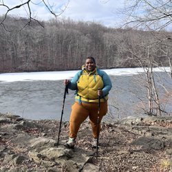
I usually have to pump myself up to go over to Abram Hewitt; even for legit North Jersey hikes, it's super out of the way (at least 20 minutes from Route 23, with minimal post-hike eating options) and there's no way to avoid having to walk on the shoulder of a busy state highway for at least 15 seconds - and often significantly more if you don't get there before literally two other cars. This particular hike I did on Saturday IS one of my favorites though and a strong recommend. You can see in the attached pictures that despite a dreary day, the optics here are pretty fantastic. You have to earn the view, and when the sun actually decides to show up, it's arguably a top two or three optic in NJ. Yesterday I did about a 7-mile hike along the Bearfort RIdge, from the trailhead on the Warwick Turnpike, up the western side of the Bearfort Ridge Trail before making a left onto the Ernest Walter Trail before connecting up with the almighty AT for a few moments, then hopping onto the blue State Line Trail before reconnecting with Ernest Walter to the Greenwood Lake overlook before going south to hook up again with the Bearfort Ridge Trail (this time on its eastern side) back to the trailhead. The whole journey took about 4 1/2 hours for me, which includes moseying along for a while and a snack break at the overlook. The parking situation is rough; it's a huge reason you can't say this is an unequivocally positive hiking experience. There's a very small parking area on the shoulder of the Warwick Turnpike that can fit three cars. That's it. There's no signage to speak of, so unless you see one or two other cars there for context, it's not even clear you're allowed to park there for a few hours. Further down Warwick going toward Greenwood Lake, there's a bigger shoulder on the other side of the road that can probably fit 10 more cars but again, no signage and parking there requires you to walk alongside Warwick for a solid few minutes with not a lot of space to avoid vehicular traffic. Not pleasant, and I think they probably could figure out a way to make this much more hospitable for hikers. There's also no port-a-potty at any point in this hike, so I'd stop at the Dunkin or something in the downtown West Milford area beforehand. This is definitely not an easy hike, but the toughest part to me is the first half hour, where you're scaling up the ridge. I prefer to get the rough stuff over at the beginning as a warmup, but it's a fairly steep climb. Once up on the ridge, you're not really doing much more in the way of significant inclines (though there is more up and down, especially on the yellow trail where you have some legit scrambling), but the terrain is VERY rocky/rough, which is to be expected. It's a lot of outcroppings and hopping from one rock formation to the next. The final 2.5 miles or so on the Bearfort is comparatively easy; it's basically just a woods road, and the most annoying part of it was the bug situation, which was nastier than usual with some recent rain. I had some sweat-resistant Off, but it barely made a dent. By far the best part of this hike is the overlook area on yellow that has viewpoints going up and down the length of Greenwood Lake. The eastern side where Sterling State Forest is has some decent eye candy as well, but this is the gold standard because there's minimal foliage on the rock outcroppings; you can just on the boulders and see everything in front of you. There's no way to get up there without doing the work so it tends not to be as crowded as some of the nearby vistas in the area; an added bonus. The trail maintenance and markings are very solid and easy to find for the most part; they were either freshly painted on rocks/trees or actual physical markers nailed down (there's probably an official term for those). The blue trail has a few issues where it's super easy to lose your way because there's more than one possible option to turn onto; an extra rock cairn or two could go a long way here. Unfortunately due to the weather the canine chum situation was nonexistent, and so were the wildlife sightings. I saw/heard a few squirrels, but nothing to write home about. If this one is on your list, I'd recommend getting there early so you're literally one of the first three cars. Otherwise, your warmup is going to consist of exhaust fumes and sadness. Very cool hike though if you can make the time. read more


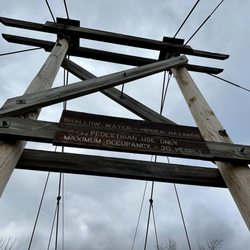
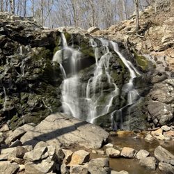
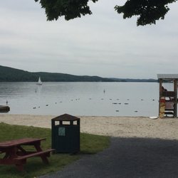
I did the Surprise Lake loop in Abram S. Hewitt State Forest this past weekend. I would say this was a intermediate level hike, there was a lot of rock scrambling. Nothing too crazy, but a few spots were a little tricky. The hike offered some challenges because of the torrential rains the previous day. The rocks were extremely slippery at some points. We carpooled to the parking lot opposite the marina. The parking lot can accommodate probably 10 cars. There was one porta potty at the parking lot, no other facilities. We started with the blue trail, followed it up to the yellow trail on the left. From yellow, we moved on to a portion of the Appalachian trail then backtracked to reach the blue all the way to the parking lot. The hike offers some great views of the Greenwood lake and the surrounding peaks and valleys from the top of the Bearfort mountain. We traversed the ridge line and arrived at the Surprise Lake where we took a break for lunch. Total distance covered was about 5 miles. We didn't spot any bears or snakes while hiking, but kept an eye out just the same as they are supposed to be common in the area. A good pair of hiking shoes will be useful on this hike, be careful while scrambling over the rocks if you're wearing sneakers. As always, carry sunscreen and map of the trail. Hiking map:http://www.nynjtc.org/files/u1/PettyHJH_chp24-SurpriseLakeLoop.pdf read more


11 years ago
13 years ago
12 years ago
More info about Abram S Hewitt State Forest
You might also consider


Abram S Hewitt State Forest - hiking - Updated May 2026
Best of West Milford
People found Abram S Hewitt State Forest by searching for…
Sunrise View in West Milford, NJ
Hiking Trails in West Milford, NJ
Lookout Points in West Milford, NJ
Walking Trails in West Milford, NJ
Off Road Trails in West Milford, NJ
Swimming Lakes in West Milford, NJ
Easy Hikes in West Milford, NJ
Scenic View in West Milford, NJ
Sunset View in West Milford, NJ
Lakes & Ponds in West Milford, NJ
Things to Do in West Milford, NJ
Running Trails in West Milford, NJ
Scenic Overlook in West Milford, NJ
Beautiful Views in West Milford, NJ
Places to Take Pictures in West Milford, NJ
Skyline View in West Milford, NJ
Photo Spots in West Milford, NJ
View Points in West Milford, NJ
Fun Things to Do at Night in West Milford, NJ
Running Routes in West Milford, NJ
Trending Searches in West Milford, NJ
Boat Rental near Abram S Hewitt State Forest
Botanical Gardens near Abram S Hewitt State Forest
Bounce House Rentals near Abram S Hewitt State Forest
Campgrounds near Abram S Hewitt State Forest
Cherry Picking near Abram S Hewitt State Forest
Cliff Jumping near Abram S Hewitt State Forest
Dog Friendly Things To Do near Abram S Hewitt State Forest
Flower Fields near Abram S Hewitt State Forest
Flower Shop near Abram S Hewitt State Forest
Garage Sales near Abram S Hewitt State Forest
Hair near Abram S Hewitt State Forest
Lakes & Ponds near Abram S Hewitt State Forest
Nurseries & Gardening near Abram S Hewitt State Forest
Outdoor Activities near Abram S Hewitt State Forest
Outdoor Furniture Stores near Abram S Hewitt State Forest
Parks near Abram S Hewitt State Forest
Party Equipment Rentals near Abram S Hewitt State Forest
Pedicure near Abram S Hewitt State Forest
Pick Your Own Farms near Abram S Hewitt State Forest
Picnic Areas near Abram S Hewitt State Forest
Places To Take Pictures near Abram S Hewitt State Forest
Running Trails near Abram S Hewitt State Forest
Scenic Drive near Abram S Hewitt State Forest
Secret Spots near Abram S Hewitt State Forest
Strawberry Picking near Abram S Hewitt State Forest
Sunrise View near Abram S Hewitt State Forest
Swimming Holes near Abram S Hewitt State Forest
Table And Chair Rentals near Abram S Hewitt State Forest
Browse Articles
Browse Nearby
BEST of West Milford, New Jersey Walking Trails near Abram S Hewitt State Forest
BEST of West Milford, New Jersey Restaurants near Abram S Hewitt State Forest
BEST of West Milford, New Jersey Things to Do near Abram S Hewitt State Forest
BEST of West Milford, New Jersey Coffee near Abram S Hewitt State Forest
BEST of West Milford, New Jersey Parks near Abram S Hewitt State Forest
BEST of West Milford, New Jersey Breakfast near Abram S Hewitt State Forest
BEST of West Milford, New Jersey Campgrounds near Abram S Hewitt State Forest
BEST of West Milford, New Jersey Hotels near Abram S Hewitt State Forest
BEST of West Milford, New Jersey Taxis near Abram S Hewitt State Forest
Browse Brands
Related Searches in West Milford, NJ
Affordable Kayak Rental Services in West Milford, New Jersey
Best Fishing Locations and Guides in West Milford, New Jersey
Best Nature Trails for Hiking in West Milford, New Jersey
Best Places for Horseback Riding in West Milford, New Jersey
Best Waterfalls and Swimming Holes in West Milford, New Jersey
Check Out Off Road Trails in West Milford, New Jersey
Discover Dog Friendly Trails to Explore in West Milford, New Jersey
Discover Scenic Mountain Bike Trails Near West Milford, New Jersey
Discover Top State Parks to Visit in West Milford, New Jersey
Discover a Hiking Trail in West Milford, New Jersey
Discover the Best Night Hike Trails in West Milford, New Jersey
Dog-Friendly Hikes With Dogs in West Milford, New Jersey
Effective Stairs Workout Spots in West Milford, New Jersey
Enjoy Camping Adventures Around West Milford, New Jersey
Enjoy Exciting Mountain Biking Adventures in West Milford, New Jersey
Enjoy Kayaking Adventures in West Milford, New Jersey
Enjoy Tent Camping Spots Around West Milford, New Jersey
Enjoy Water Activities and Fun in West Milford, New Jersey
Enjoy the Best Walking Trails in West Milford, New Jersey
Exciting Cliff Jumping Spots in West Milford, New Jersey
Experience Thrilling White Water Rafting in West Milford, New Jersey
Explore Beautiful Parks and Green Spaces in West Milford, New Jersey
Explore Easy Hikes Perfect for All in West Milford, New Jersey
Explore Popular Campgrounds Near West Milford, New Jersey
Explore Popular Scenic Overlook Points in West Milford, New Jersey
Explore Popular View Points Around West Milford, New Jersey
Explore Scenic Lakes to Visit in West Milford, New Jersey
Explore the Best Beach Spots in West Milford, New Jersey
Explore the Best Boating Spots in West Milford, New Jersey
Explore the Best Swimming Holes Around West Milford, New Jersey
Family Friendly Hiking With Kids in West Milford, New Jersey
Find Beautiful Views in West Milford, New Jersey
Find Fun Kids Activities Outdoor in West Milford, New Jersey
Find Popular Ziplining Spots Around West Milford, New Jersey
Find the Best Playgrounds to Visit in West Milford, New Jersey
Find the Best Scenic View Locations in West Milford, New Jersey
Hiking Trails With Waterfalls in West Milford, New Jersey
Off Leash Dog Hiking Trails in West Milford, New Jersey
Plan a Scenic Drive Route Near West Milford, New Jersey
Popular Fishing Spots to Explore in West Milford, New Jersey
Popular Picnic Spots to Visit in West Milford, New Jersey
Safe River Swimming Areas in West Milford, New Jersey
Safe and Fun Parks for Kids in West Milford, New Jersey
Top Paddleboarding Activities in West Milford, New Jersey
Top Places for Snorkeling in West Milford, New Jersey
Top Running Trails to Explore in West Milford, New Jersey
Top Swimming Lakes to Enjoy in West Milford, New Jersey
Top Swimming Spots and Pools in West Milford, New Jersey
Walk Dog Friendly Hiking Trails in West Milford, New Jersey
Walk the Best Paved Walking Trails in West Milford, New Jersey
People who viewed Abram S Hewitt State Forest also viewed
Paterson Great Falls National Historical Park
128 reviews
Pompton Valley Rail Trail
2 reviews
Franklin Lakes Nature Preserve
16 reviews
Jacqueline Kennedy Onassis Reservoir
111 reviews
Central Park
New Jersey Botanical Garden
20 reviews
Rifle Camp Park
14 reviews
Ringwood State Park at Ringwood Manor
48 reviews
Giant Stairs Palisades
1 review
Rockland Lake State Park
63 reviews
Rockefeller Lookout
9 reviews