Westview Park Photos


You might also consider
More like Westview Park
Recommended Reviews - Westview Park
Start your review...

9 years ago
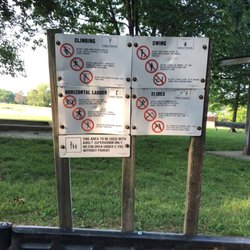
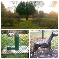
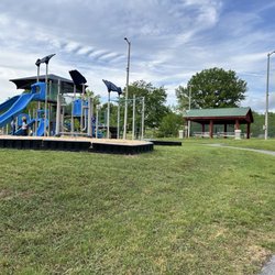
Westview Park is a nice, little neighborhood park. My boys like to walk or bike to it as it's close to our place. It is usually quiet and utilized by young families. Here's the amenities: *paved parking lot *basketball court *baseball field *playground equipment *pavilion with picnic table *benches *large, grassy field *port-a-potty (seasonal?) *small pond read more


13 years ago
Basketball court and baseball diamond dominate this residential park. Two small playground features round out quiet corner of the world. read more
More info about Westview Park
650 School Ln
Mount Joy, PA 17552
Directions
Hours
Outdoor Amenities
You might also consider


Westview Park - parks - Updated June 2026
Best of Mount Joy
People found Westview Park by searching for…
Playgrounds in Mount Joy, Pennsylvania
Things to Do in Mount Joy, Pennsylvania
Softball Fields in Mount Joy, Pennsylvania
Places to Take Pictures in Mount Joy, Pennsylvania
Picnic Spots in Mount Joy, Pennsylvania
Table Tennis in Mount Joy, Pennsylvania
Baseball Store in Mount Joy, Pennsylvania
Lakes & Ponds in Mount Joy, Pennsylvania
Parks for Picnics in Mount Joy, Pennsylvania
Photo Spots in Mount Joy, Pennsylvania
Free Indoor Basketball Court in Mount Joy, Pennsylvania
River Swimming in Mount Joy, Pennsylvania
State Parks in Mount Joy, Pennsylvania
Open Gym Basketball Court in Mount Joy, Pennsylvania
Youth Basketball in Mount Joy, Pennsylvania
Running Trails in Mount Joy, Pennsylvania
Picnic Areas in Mount Joy, Pennsylvania
Splash Pad in Mount Joy, Pennsylvania
Free Swimming Pool in Mount Joy, Pennsylvania
Pitch and Putt in Mount Joy, Pennsylvania
Picnic Tables in Mount Joy, Pennsylvania
Swimming Holes in Mount Joy, Pennsylvania
Trending Searches in Mount Joy, PA
Baseball Fields near Westview Park
Black Owned Nail Salons near Westview Park
Boat Rental near Westview Park
Cliff Jumping near Westview Park
Dog Friendly Beaches near Westview Park
Fishing Spots near Westview Park
Free Kids Activities near Westview Park
Free Picnic Areas near Westview Park
Free Things To Do With Kids near Westview Park
Jet Ski Rental near Westview Park
Kids Activities Outdoor near Westview Park
Parks With Pull Up Bars near Westview Park
Pick Your Own Farms near Westview Park
Soccer Store near Westview Park
Strawberry Picking near Westview Park
Swimming Holes near Westview Park
Swimming Lakes near Westview Park
Swimming Pools near Westview Park
Browse Articles
Browse Nearby
Browse Brands
Related Searches in Mount Joy, PA
Best Fishing Locations and Guides in Mount Joy, Pennsylvania
Best Gym With Sauna Amenities in Mount Joy, Pennsylvania
Best Off Leash Dog Parks in Mount Joy, Pennsylvania
Best Parks for Parties and Events in Mount Joy, Pennsylvania
Best Racquetball Court Options in Mount Joy, Pennsylvania
Best Softball Fields Available in Mount Joy, Pennsylvania
Best Track and Field Facilities in Mount Joy, Pennsylvania
Best Turf Fields for Sports and Events in Mount Joy, Pennsylvania
Best Waterfalls and Swimming Holes in Mount Joy, Pennsylvania
Check Out Great Playgrounds in Mount Joy, Pennsylvania
Check Out Off Road Trails in Mount Joy, Pennsylvania
Discover Free Parking Options in Mount Joy, Pennsylvania
Discover Fun Activities to Do in Mount Joy, Pennsylvania
Discover Fun Toddler Parks in Mount Joy, Pennsylvania for Your Little One
Discover Lakes & Ponds to Explore in Mount Joy, Pennsylvania
Discover Soccer Fields in Mount Joy, Pennsylvania Near You
Discover Top Nature Parks to Visit in Mount Joy, Pennsylvania
Discover the Best Beaches in Mount Joy, Pennsylvania
Discover the Best Running Track in Mount Joy, Pennsylvania
Enjoy Hiking Adventures in Mount Joy, Pennsylvania
Enjoy the Best Night View Spots in Mount Joy, Pennsylvania
Enjoy the Best Walking Trails in Mount Joy, Pennsylvania
Experience Stunning Sunset Views in Mount Joy, Pennsylvania
Explore Basketball Leagues in Mount Joy, Pennsylvania
Explore Beautiful Parks and Green Spaces in Mount Joy, Pennsylvania
Explore Boxing Gyms in Mount Joy, Pennsylvania
Explore Family-Friendly Zoos and Wildlife in Mount Joy, Pennsylvania
Explore Free Picnic Areas Around Mount Joy, Pennsylvania
Explore Fun Activities to Do in Mount Joy, Pennsylvania
Explore Gyms With Pool Access in Mount Joy, Pennsylvania
Explore Indoor Tennis Courts in Mount Joy, Pennsylvania
Explore Landmarks & Historical Buildings in Mount Joy, Pennsylvania
Explore Parks With Pull Up Bars in Mount Joy, Pennsylvania
Explore Popular Campgrounds Near Mount Joy, Pennsylvania
Explore Popular RV Parks Around Mount Joy, Pennsylvania
Explore Popular Recreation Centers Around Mount Joy, Pennsylvania
Explore Popular Sports Clubs in Mount Joy, Pennsylvania
Explore Scenic Lakes to Visit in Mount Joy, Pennsylvania
Explore Top Dog Parks in Mount Joy, Pennsylvania Near You
Explore Top Gyms in Mount Joy, Pennsylvania Now
Explore Top Water Parks in Mount Joy, Pennsylvania Today
Explore Top-Rated Mma Gyms in Mount Joy, Pennsylvania Near You
Explore Volleyball Courts Available in Mount Joy, Pennsylvania
Explore the Best Crossfit Gyms in Mount Joy, Pennsylvania
Find Affordable Cheap Gyms to Join in Mount Joy, Pennsylvania
Find Batting Cages Near You in Mount Joy, Pennsylvania
Find Indoor Basketball Courts in Mount Joy, Pennsylvania
Find Open Indoor Basketball Courts in Mount Joy, Pennsylvania
People who viewed Westview Park also viewed
Edgewood Executive Park
3 reviews
Rocky Ridge County Park
6 reviews
Stauffer Park
1 review
Penbrook Community Park
1 review
Reservoir Park
1 review
Brookside Park
2 reviews
Stonewood Park
2 reviews
Elizabethtown Borough Community Park
2 reviews
Northwest Lancaster County River Trail
8 reviews
Kenbrook Bible Camp
1 review