Westside Preserve Photos


You might also consider
More like Westside Preserve
Recommended Reviews - Westside Preserve
Start your review...

4 years ago
What can I say that I haven't said? Great question. This place is always and will always be our place to go visit. Watching the sunset is amazing. It's just a great place to go unwind, relax and enjoy the view. This place is breathtaking all of the time. We went here tonight to enjoy an adult beverage and relax. read more


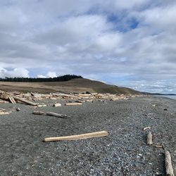
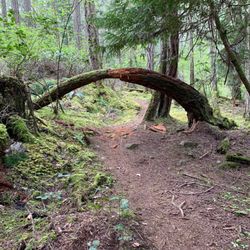
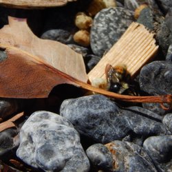
I made a short exploring stop at the Westside Preserve on Friday the 22nd of May 2020. The preserve is located along the water and Westside Road and provides some spectacular views of the Haro Strait. Signage along the road marks the edge of the preserve. Additional signs by the parking lots provide background information, rules, and trail maps. It is a bit of a windy place, so make sure to dress accordingly. There are also few trees, which is nice if you want to soak in the sunlight. A number of people were there when I stopped (around 12:30 p.m.) sitting in various places and watching the water. I ventured along part of the trail system taking in the different views, plants, and wildlife. Lots of space on the rocks overlooking the water to sit and rest and/or have a picnic. read more


More info about Westside Preserve


Westside Preserve - parks - Updated July 2026
Best of Friday Harbor
People found Westside Preserve by searching for…
Watch Sunset in Friday Harbor, Washington
Things to Do in Friday Harbor, Washington
Hiking Trails in Friday Harbor, Washington
Lookout Points in Friday Harbor, Washington
BBQ Park in Friday Harbor, Washington
Duck Pond in Friday Harbor, Washington
Picnic Spots in Friday Harbor, Washington
Places to Take Pictures in Friday Harbor, Washington
Views in Friday Harbor, Washington
Picnic Parks in Friday Harbor, Washington
Walking Trails in Friday Harbor, Washington
Sunset View in Friday Harbor, Washington
Running Trails in Friday Harbor, Washington
Picnic Areas in Friday Harbor, Washington
Baseball Fields in Friday Harbor, Washington
Wildlife Park in Friday Harbor, Washington
Off Road Trails in Friday Harbor, Washington
Fishing Spots in Friday Harbor, Washington
Tide Pools in Friday Harbor, Washington
Playgrounds in Friday Harbor, Washington
River Swimming in Friday Harbor, Washington
Bird Sanctuary in Friday Harbor, Washington
Trending Searches in Friday Harbor, WA
4th Of July Fireworks near Westside Preserve
Baseball Fields near Westside Preserve
Blueberry Picking near Westside Preserve
Boardwalk near Westside Preserve
Boat Rental near Westside Preserve
Cliff Jumping near Westside Preserve
Day Trips near Westside Preserve
Dog Friendly Beaches near Westside Preserve
Fireworks near Westside Preserve
Fishing Spots near Westside Preserve
Jet Ski Rental near Westside Preserve
Kayak Rental near Westside Preserve
Outdoor Basketball Courts near Westside Preserve
Soccer Store near Westside Preserve
Splash Pad near Westside Preserve
Strawberry Picking near Westside Preserve
Sunbathing near Westside Preserve
Swimming Holes near Westside Preserve
Swimming Lakes near Westside Preserve
U Pick Farms near Westside Preserve
Browse Articles
Browse Nearby
Browse Brands
Related Searches in Friday Harbor, WA
Best Off Leash Dog Parks in Friday Harbor, Washington
Best Parks for Parties and Events in Friday Harbor, Washington
Check Out Great Playgrounds in Friday Harbor, Washington
Discover Baseball Fields Around Friday Harbor, Washington
Discover Beautiful Garden Spots in Friday Harbor, Washington
Discover Fun Activities to Do in Friday Harbor, Washington
Discover Lakes & Ponds to Explore in Friday Harbor, Washington
Discover Popular Photo Spots in Friday Harbor, Washington
Discover Soccer Fields in Friday Harbor, Washington Near You
Discover the Best Beaches in Friday Harbor, Washington
Enjoy the Best Picnic Spots and Ideas in Friday Harbor, Washington
Enjoy the Best Walking Trails in Friday Harbor, Washington
Explore Beautiful Botanical Gardens in Friday Harbor, Washington
Explore Family-Friendly Zoos and Wildlife in Friday Harbor, Washington
Explore Free Picnic Areas Around Friday Harbor, Washington
Explore Fun Activities to Do in Friday Harbor, Washington
Explore Parks With Pull Up Bars in Friday Harbor, Washington
Explore Popular Campgrounds Near Friday Harbor, Washington
Explore Popular Picnic Areas Around Friday Harbor, Washington
Explore Popular RV Parks Around Friday Harbor, Washington
Explore Popular Recreation Centers Around Friday Harbor, Washington
Explore Scenic Lakes to Visit in Friday Harbor, Washington
Explore Secret Spots Worth Visiting in Friday Harbor, Washington
Explore Top Dog Parks in Friday Harbor, Washington Near You
Explore Top Gyms in Friday Harbor, Washington Now
Find Beautiful Views in Friday Harbor, Washington
Find Top Dog Friendly Parks to Visit in Friday Harbor, Washington
Find Top Skate Parks in Friday Harbor, Washington for All Skill Levels
Find Top Skating Rinks in Friday Harbor, Washington for All Ages
Find a Park With BBQ Pits in Friday Harbor, Washington
Find the Best Parks BBQ Grills in Friday Harbor, Washington
Find the Best Swimming Pools in Friday Harbor, Washington Today
Fun Things for Kids in Friday Harbor, Washington
Great Places to Swim in Friday Harbor, Washington
Have Fun at a Splash Pad in Friday Harbor, Washington
Indoor Playgrounds to Explore in Friday Harbor, Washington
Locate Tennis Courts Around Friday Harbor, Washington
Must-See Tourist Attractions Around Friday Harbor, Washington
Picnic Areas With BBQ Pits Available in Friday Harbor, Washington
Popular Kids Activities in Friday Harbor, Washington
Popular Outdoor Activities to Try in Friday Harbor, Washington
Popular Places to Take Pictures in Friday Harbor, Washington
Top Hiking Trails to Explore in Friday Harbor, Washington
Top Running Trails to Explore in Friday Harbor, Washington
Top Swimming Lakes to Enjoy in Friday Harbor, Washington
Top Things to Do With Kids in Friday Harbor, Washington
Top-Rated Basketball Courts to Play at in Friday Harbor, Washington
Top-Rated Hikes in Friday Harbor, Washington to Explore
Visit Popular Museums in Friday Harbor, Washington Now
Visit the Best Kids Play Place Options in Friday Harbor, Washington
People who viewed Westside Preserve also viewed
Turtleback Mountain Preserve
11 reviews
Crescent Beach Preserve
3 reviews
Watmough Bay Preserve
1 review
San Juan Island National Historic Park
19 reviews
Moran State Park
12 reviews
San Juan Park
10 reviews
Blakely Island
1 review
San Juan Islands Sculpture Park
32 reviews
Mt. Grant Preserve
3 reviews
Henry Island
1 review