West Twin Peak Photos


You might also consider
More like West Twin Peak
Recommended Reviews - West Twin Peak
Start your review...

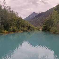
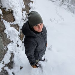
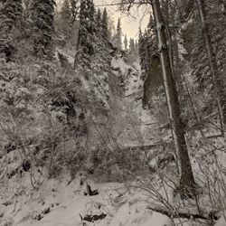
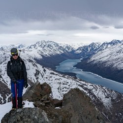
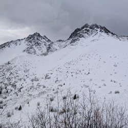
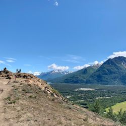
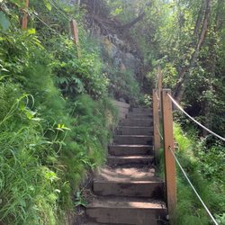
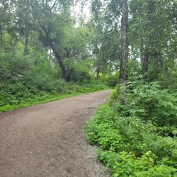
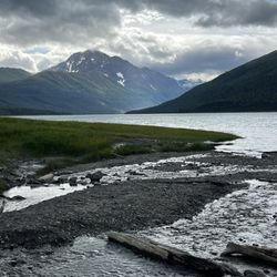
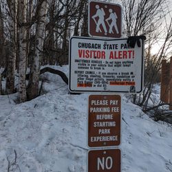
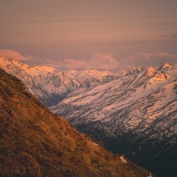
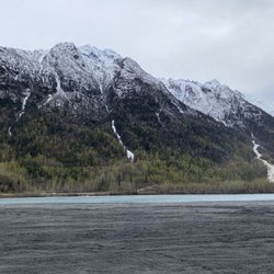
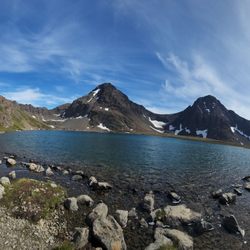
The climb to this peak starts at the overflow lot (where all the ATVrs park) for the Eklutna Lake Trailhead: https://www.yelp.com/biz/eklutna-lakeside-trail-eklutna Somehow I'd gotten it into my thick skull that West Twin was more difficult that East Twin (https://www.yelp.com/biz/east-twin-peak-palmer). Somehow I've done East Twin twice, and back-burnered West Twin. I was wrong. I was silly. This is probably one of the most pleasant peak-bagging experiences I've had in the Chugach: - no people - amazing fall weather: crisp and cold on approach; sunny, warm, and glorious for the rest of the day - fun "bushwhacking": you go through the trees but it's very quick and easy travel - great summit views: fun to take shots of people on the summit of East Twin, I wish I had brought my telephoto! - lots of lazy sheep - we got back in time for ice cream at Rochelle's (https://www.yelp.com/biz/rochelles-ice-cream-stop-chugiak) read more

 and East Twin - Hiking Near Me - Anchorage, Alaska")


More info about West Twin Peak


West Twin Peak - hiking - Updated July 2026
Best of Anchorage
People found West Twin Peak by searching for…
Scenic Overlook in Anchorage, Alaska
Scenic Views in Anchorage, Alaska
Secret Spots in Anchorage, Alaska
Places to Take Pictures in Anchorage, Alaska
Waterfalls in Anchorage, Alaska
Things to Do in Anchorage, Alaska
Beautiful Views in Anchorage, Alaska
Playgrounds in Anchorage, Alaska
Hiking Trails in Anchorage, Alaska
Walking Trails in Anchorage, Alaska
Public Shower in Anchorage, Alaska
Sunset View in Anchorage, Alaska
Indoor Rock Climbing in Anchorage, Alaska
Sunrise View in Anchorage, Alaska
Off Road Trails in Anchorage, Alaska
Free Campgrounds in Anchorage, Alaska
Off Leash Dog Parks in Anchorage, Alaska
Lookout Points in Anchorage, Alaska
Running Trails in Anchorage, Alaska
Trending Searches in Anchorage, AK
Boat Rental near West Twin Peak
Dog Friendly Trails near West Twin Peak
Dog Swimming near West Twin Peak
Kayak Rental near West Twin Peak
Off Road Trails near West Twin Peak
Outdoor Activities near West Twin Peak
Parks For Picnics near West Twin Peak
Public Pools near West Twin Peak
Public Shower near West Twin Peak
River Swimming near West Twin Peak
Rock Quarry near West Twin Peak
Scenic Overlook near West Twin Peak
Soccer Store near West Twin Peak
Sunrise View near West Twin Peak
Swimming Holes near West Twin Peak
Swimming Lakes near West Twin Peak
Browse Articles
Browse Nearby
Browse Brands
Related Searches in Anchorage, AK
Affordable Kayak Rental Services in Anchorage, Alaska
Best Fishing Locations and Guides in Anchorage, Alaska
Best Fun Things to Do in Anchorage, Alaska
Best Gym With Sauna Amenities in Anchorage, Alaska
Best Places for Horseback Riding in Anchorage, Alaska
Check Out Off Road Trails in Anchorage, Alaska
Discover Dog Friendly Trails to Explore in Anchorage, Alaska
Discover Exciting Adventure Options in Anchorage, Alaska
Discover Fun Activities to Do in Anchorage, Alaska
Discover Fun Kid Activities to Enjoy in Anchorage, Alaska
Discover Great Fitness Classes Available in Anchorage, Alaska
Discover Gyms With Steam Room Options in Anchorage, Alaska
Discover Scenic Running Paths in Anchorage, Alaska
Discover Scenic Waterfall Spots in Anchorage, Alaska
Discover Top Boat Tours in Anchorage, Alaska for All Ages
Discover Top Yoga Options and Studios in Anchorage, Alaska
Discover a Hiking Trail in Anchorage, Alaska
Discover the Best Night Hike Trails in Anchorage, Alaska
Discover the Best Running Track in Anchorage, Alaska
Dog-Friendly Hikes With Dogs in Anchorage, Alaska
Enjoy Camping Adventures Around Anchorage, Alaska
Enjoy Hiking Adventures in Anchorage, Alaska
Enjoy Kayaking Adventures in Anchorage, Alaska
Enjoy Tent Camping Spots Around Anchorage, Alaska
Enjoy a Beautiful Waterfall Hike in Anchorage, Alaska
Enjoy the Best Tubing Experiences in Anchorage, Alaska
Enjoy the Best Walking Trails in Anchorage, Alaska
Explore Beautiful Parks and Green Spaces in Anchorage, Alaska
Explore Bike Rentals Throughout Anchorage, Alaska
Explore Boxing Gyms in Anchorage, Alaska
Explore Easy Hikes Perfect for All in Anchorage, Alaska
Explore Fitness Centers and Gyms in Anchorage, Alaska
Explore Fun Activities to Do in Anchorage, Alaska
Explore Martial Arts Options in Anchorage, Alaska
Explore Popular Campgrounds Near Anchorage, Alaska
Explore Popular RV Parks Around Anchorage, Alaska
Explore Popular Recreation Centers Around Anchorage, Alaska
Explore Popular Scenic Overlook Points in Anchorage, Alaska
Explore Popular Sports Clubs in Anchorage, Alaska
Explore Scenic Lakes to Visit in Anchorage, Alaska
Explore Summer Camps for All Ages in Anchorage, Alaska
Explore Top Dog Parks in Anchorage, Alaska Near You
Explore Top Gyms in Anchorage, Alaska Now
Explore Top Water Parks in Anchorage, Alaska Today
Explore the Best Boating Spots in Anchorage, Alaska
Explore the Best Rock Climbing Areas in Anchorage, Alaska
Explore the Best Trail Options in Anchorage, Alaska
Family Friendly Hiking With Kids in Anchorage, Alaska
People who viewed West Twin Peak also viewed
Bodenburg Butte
9 reviews
Lazy Mountain Trail Head
4 reviews
South Fork Falls
14 reviews
North Fork Eagle River Trailhead
1 review
Thunderbird Falls Parking Area and Trailhead
39 reviews
Alaska Zipline Adventure Park
7 reviews
Bold Peak
1 review
Alaska Horse Adventures
27 reviews
Moose Run Golf Course
10 reviews
Craig Fellin Outfitters & Big Hole Lodge
1 review