1. West Ridge Trail

0

Aliso Viejo, CA

Cancel

Open app

Search

West Ridge Trail

5.0 (5 reviews)

WEST RIDGE TRAIL · YELP ASSISTANT

Ask Yelp Assistant

West Ridge Trail Photos

You might also consider

Recommended Reviews - West Ridge Trail

Your trust is our priority, so businesses can't pay to alter or remove their reviews. Learn more about reviews.
Yelp app icon
Browse more easily on the app
Review Feed Illustration

Reviews With Photos

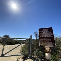
Entrance
Sharmaine A.

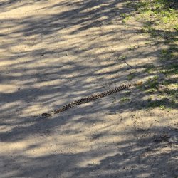
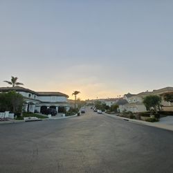
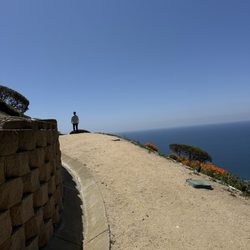
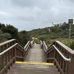
Being the first trail listed on an "OC hikes with amazing views" article, naturally I had to see this so called amazing for myself! This trail is part of Aliso and Wood Canyons Wilderness Park & tucked away in a little residential area with street parking. There are many signs throughout the trail to lead you, so that definitely makes solo hikers like myself feel more comfortable. This trail is about 4.5 miles long & a breeze to get through, with just a few mini inclines every now and then. It does get slightly crowded but with how extra wide the trail is, don't worry about any fellow hikers being in a close proximity to you. Tons of bikers & families take this route, as well. I really like this trail because the views are so breath taking (literally haha) that I just wanted to stop & take it all in every 10 minutes. Once you get to the end of the trail, which is Top of the World in Laguna Beach, that's when you'll really be in awe of nature's beauty - sea on one side & hills on the other. This hike will get your heart pumping but it's not strenuous enough to say it's the most difficult, very doable for anyone.

See all

7 years ago

Helpful 4
Thanks 0
Love this 2
Oh no 0

9 months ago

Helpful 0
Thanks 0
Love this 0
Oh no 0

9 months ago

Beautiful and you are able to do solo!! It's a good start to be able to big more advanced hikes!

Helpful 0
Thanks 0
Love this 0
Oh no 0

6 years ago

Helpful 18
Thanks 0
Love this 12
Oh no 1

6 years ago

Helpful 0
Thanks 0
Love this 0
Oh no 1

You might also consider

Verify this business for free

People searched for Hiking 4,436 times last month within 15 miles of this business.

Verify this business

Turtle Rock Viewpoint Trail

Turtle Rock Viewpoint Trail

4.2(144 reviews)
3.6 mi

Very much enjoyable, but this hike does require conditioning in my opinion. I found the first hill…read moreto be steep and tiring. After making it to the top of the turtle rock trail most of the walking past that point was relatively downhill, sometimes steep drops. You definitely need a pair of good hiking shoes for this venture (the Nikes I had didn't grip steep slopes up or down well. Awesome sights once you reach the top.

First time visiting this trail / loop There are multiple…read moreentrances to the loop Street or residential parking Look out for signs with designated street parking signs or resident parking only If parking across chaparral park there are stairs that lead to trail head once on the top or another pathway to the right that another start to the trail There is another entrance off Concordia with street parking (no parking between 9pm to 6am) and a little sign that says turtle rock Trail overlooks the city - greenery and fields can be seen Definetly bring a hat and water and wear sturdy shoes because it's a combination of flat up down rocky hills Wear long pants as some pathways are narrow Overgrown brush / branches / bushes Appears to be dog friendly trail Watch out for various forms of number 2 No bathrooms available All trail helpful to ensure following the loop as it does take you through some residential area and some pathways branch off into a left or right or curvy direction Enjoy and start early if you can to beat the heat. 4 miles at least pending route taken and took 1.5 to 2 hours to complete Have fun!

Photos
Turtle Rock Viewpoint Trail - Top of turtle rock

Top of turtle rock

Turtle Rock Viewpoint Trail - Happy pup

Happy pup

Turtle Rock Viewpoint Trail - Not much effort needed to get to this!

See all

Not much effort needed to get to this!

Oso Creek Trail

Oso Creek Trail

4.6(119 reviews)
5.7 mi

The Oso Creek Trail is a classic "Yuppie Nature" trail: mostly paved or manicured paths, and…read morenothing too challenging or dangerous. Exactly the kind of "outdoor" experience my wife loves! But seriously, it's a wonderful place to stretch your legs right in the heart of Mission Viejo. The trail runs along both sides of Oso Creek, hence the name, and each side of the trail is a bit different. One side is paved and the other is dirt or bark covered, for a more "natural" feel. There are also some fun points of interest along the way, including a hedgerow maze, various bear statues, and a park adjacent to the Norman P. Murray Community & Senior Center. It's great for families with small kids or strollers to push, as well as solo joggers, dog walkers, or even bikers. It's long enough and stretches at least a couple miles to get some good exercise in. If you're in the area, it's well worth a visit to enjoy. Five stars!

This urban trail, which runs along Oso Creek for a couple of miles, has several entrances along…read morethe route. We entered at the south trailhead on Marguerite Parkway next to Del Taco. The path itself was paved for the first mile or so and then became dirt/sawdust. While the trail runs behind and below shopping centers and housing, you never really see much of the structures. We walked a good chunk of the trail to the Peace Obelisk and then turned around and went back to where we parked in a shopping center, which was approximately a 4-mile round trip. It was a good walk on a Saturday afternoon. There weren't a whole lot of people to be seen on our walk; a few families, dog walkers, a couple of joggers, a couple of bicyclists. The entire path is an easy walk and mostly flat. Again, there are several entrances to the trail and there are actually 2 separate parallel trails on either side of the creek. This is a great place to spend a little time in nature while still being in the middle of Mission Viejo.

Photos
Oso Creek Trail
Oso Creek Trail
Oso Creek Trail

See all

Aliso Peak Trail - Midnight from Aliso Peak

Aliso Peak Trail

4.5(12 reviews)
5.0 mi

This is a really cool trail that starts out from Pacific Island Street goes past some residential…read moreneighborhoods and ends up with a beautiful view of Pacific Ocean it can continue down to PCH as well

Aliso Peak Trail is a little gem with various combo of extension trails. The trail starts out flat…read morewith a few picnic tables on the side of the trail. Then you proceed down on a steep, narrow dirt/rocky path. There are just a few rolling hills before you reach the peak. Before the final peak, there are wooden planks to step on/assist in hiking up. On a clear day you can see the canyon with a clear coastal view of Laguna Beach; on a foggy day, you'd still enjoy the ethereal view where mountain meets water/coast. Distance: ~ 2 miles roundtrip Trailhead: Seaview Park at Talavera and Casalero Parking: free along residential street Condition: dirt path, steep climb with little rocks Level: Advanced beginner NOTE: there are no restroom nearby or on the trail. If you're on time constraint and want a short cardio workout (~ 2miles roundtrip), start from Seaview park and descend down for a view of the ocean coast, coastal fog, and breezy wind. For more mileage, start from Aliso Summit Trail (Ridgeview and Highland, add about 6 miles roundtrip) then connect to Aliso Peak (total ~8 miles roundtrip); for additional adventure, descend via Valido trail to the beach.

Photos
Aliso Peak Trail - Overlooking the Aliso Peak from above the trail

Overlooking the Aliso Peak from above the trail

Aliso Peak Trail - Aliso Peak 4th of July 2017

Aliso Peak 4th of July 2017

Aliso Peak Trail - Marker at the top of Aliso Peak

See all

Marker at the top of Aliso Peak

Canyon View Park

Canyon View Park

4.5(27 reviews)
0.3 mi

This is my entry way to hiking on the Wood Canyon Trail which runs south. have not used any…read moreamenities offered here at this park. I do appreciate free street parking. A past memory I have was getting to play with a dog whose owner we playing catch with on the grass here.

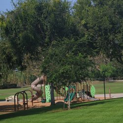
Love strolling through Canyon View Park but only on weekdays…read more Parking here is nonexistent. You have to parallel park in specific areas and specific side of the street only. It's in the middle of a residential neighborhood and it will be hard to park during the weekends. It's an otherwise peaceful area to walk around in unless you have the unfortunate encounters with unleashed dogs, shrieking children due to the two playgrounds, or inconsiderate people talking extremely loudly on their smartphones. Sometimes you will encounter all 3 and by then, the walk with my dogs are ruined. My one dog is extremely shy and timid so I frequently have to carry her back to the car with another pulling beagle in tow. No fun at all. The poop bag stations are inconsistently filled and the park has dog droppings hidden in any areas of the grass or sidewalk. So if your dogs tend to eat stuff off the ground, WATCH OUT! Mine tried to roll in it and I so didn't appreciate it. The park also leads to several different trails that allows dogs for some of the paths. It will be an extremely steep hill to climb up and down if you access it from the Canyon View Park side. Not for the faint of heart and be aware it has little to no shade. Bring water, and don't attempt to climb if you have sandals on. It will get your feet dusty and good pair of NB or Hokas would really help. In all, I think it's a decent park to go to, but not my first choice due to noise, dog droppings, and ease of access. Avoid on weekends unless you like crowds.

Photos
Canyon View Park
Canyon View Park
Canyon View Park - Volleyball Field

See all

Volleyball Field

West Ridge Trail - hiking - Updated November 2026

Loading...
Loading...
Loading...