Wallace Creek Interpretive Trail Photos


You might also consider
More like Wallace Creek Interpretive Trail
Recommended Reviews - Wallace Creek Interpretive Trail
Start your review...

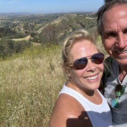
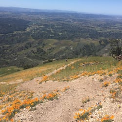
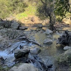
Welcome to San Andreas... The Wallace Creek Interpretive Trail is a must stop if you're touring the Carrizo Plain National Monument. While you really don't get the awesome views of a large tear in the ground, there is plenty of evidence of pointing that the San Andreas fault is here . Temper expectations... There are also great views of the landscape and Wallace Creek does have some cool twists and elbows. Be sure to grab a guide at the parking lot because there are some fun field exercises you can do while on the trail. Tips - If you're planning on visiting here write down the directions and bring them. Do not trust the GPS or Yelp directions. Wallace Creek is in the middle of nowhere with little or no cell service. Also, Elkhorn Road is a dirt road about 4 or so miles long... Our rental car made it fine, but we had to drive slowly.. - The Fault trail ( Sign Posts #3, 4, and 5) are NOT along the trail on top of the hill ( Numbered Post #1). That was a huge and tiring mistake by us. It's actually the humble trail below it to the south ( Extreme right from the kiosk below the hill - See my picture) read more


5 years ago
More info about Wallace Creek Interpretive Trail
You might also consider


Wallace Creek Interpretive Trail - hiking - Updated July 2026
Best of McKittrick
Browse Brands
Browse Articles
People found Wallace Creek Interpretive Trail by searching for…
Lakes in McKittrick, California
Flower Field in McKittrick, California
Hiking Trails in McKittrick, California
Running Trails in McKittrick, California
Places to Take Pictures in McKittrick, California
National Parks in McKittrick, California
Off Road Trails in McKittrick, California
Things to Do in McKittrick, California
Tours in McKittrick, California
Beautiful Views in McKittrick, California
View Points in McKittrick, California
Swimming Lakes in McKittrick, California
Jogging Trails in McKittrick, California
Views in McKittrick, California
Playgrounds for Kids in McKittrick, California
Fishing Spots in McKittrick, California
Park & Forests in McKittrick, California
Easy Hikes in McKittrick, California
Lakes & Ponds in McKittrick, California
Running Routes in McKittrick, California
People who viewed Wallace Creek Interpretive Trail also viewed
Tule Elk State Natural Reserve
15 reviews
Soda Lake Overlook and Boardwalk
10 reviews
Los Padres National Forest
14 reviews
Taft Rails to Trails
2 reviews
Carrizo Plain National Monument Painted Rock Guided Tour
2 reviews
Buttonwillow Recreation and Park District
2 reviews
Kern River Valley Bike Trail
3 reviews
Buttonwillow Raceway Park
66 reviews
West Side Recreation & Park District
4 reviews
7s Only Racing
5 reviews