Vermillion Cliffs Photos


You might also consider
More like Vermillion Cliffs
Recommended Reviews - Vermillion Cliffs
Start your review...

3 years ago
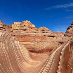
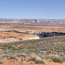
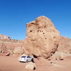
I didn't dig too deep into Vermillion Cliffs, nor was I lucky enough to undertake The Wave, but I did rearrange my road trip map just so I could drive by and see it. SO worth it!! I wish I had given myself a little extra time to take it all in but even just stopping a few times by the road and visiting the Blanche Russell Rock House was worth the extra time I added to my drive. Absolutely stunning. I still remember the moment I crested over the exit of Kaibab National Forest and saw the cliffs in the distance. Photos don't do it justice. That juxtaposition between the forests I've just left behind and the dusty red landscape ahead of me was incredible. Definitely a highlight of the drive. Now that I've done some reconnaissance I definitely plan to give myself more time time to explore one of the trails and hopefully catch a glimpse of one of the endangered california condors that call the cliffs home! read more


2 years ago
If you love history, long drives or cool rock formations this place has it all. Before my dad passed we spent some time on a road trip through here and it was wonderful. It's definitely a pretty desolate area still along the way, but worth seeing atleast once. read more


More info about Vermillion Cliffs


Vermillion Cliffs - hiking - Updated June 2026
Best of Marble Canyon
People found Vermillion Cliffs by searching for…
Off Road Trails in Marble Canyon, Arizona
Photo Spots in Marble Canyon, Arizona
Things to Do at Night in Marble Canyon, Arizona
Picnic Areas in Marble Canyon, Arizona
Things to Do in Marble Canyon, Arizona
Scenic Drive in Marble Canyon, Arizona
Sand Dunes in Marble Canyon, Arizona
Scenic View in Marble Canyon, Arizona
Swimming in Marble Canyon, Arizona
Tourist Attractions in Marble Canyon, Arizona
Hiking Trails in Marble Canyon, Arizona
Things to Do on a Rainy Day in Marble Canyon, Arizona
Fishing Spots in Marble Canyon, Arizona
River Swimming in Marble Canyon, Arizona
Sunset View in Marble Canyon, Arizona
Running Trails in Marble Canyon, Arizona
Fireworks in Marble Canyon, Arizona
Night View in Marble Canyon, Arizona
Picnic Spots in Marble Canyon, Arizona
Cave in Marble Canyon, Arizona
Sunrise View in Marble Canyon, Arizona
Public Showers in Marble Canyon, Arizona
Browse Nearby
BEST of Marble Canyon, Arizona Things to Do near Vermillion Cliffs
BEST of Marble Canyon, Arizona Parks near Vermillion Cliffs
BEST of Marble Canyon, Arizona Scenic View near Vermillion Cliffs
BEST of Marble Canyon, Arizona Restaurants near Vermillion Cliffs
BEST of Marble Canyon, Arizona Coffee near Vermillion Cliffs
BEST of Marble Canyon, Arizona Campgrounds near Vermillion Cliffs
BEST of Marble Canyon, Arizona Breakfast near Vermillion Cliffs
Browse Brands
Browse Articles
People who viewed Vermillion Cliffs also viewed
Lees Ferry - Glen Canyon Recreational Area
10 reviews
Grandview Overlook Park
2 reviews
Wahweap Overlook
14 reviews
Toadstool Trailhead
13 reviews
Biidi The Arch
2 reviews
Lower Antelope Canyon
34 reviews
The New Wave
3 reviews
Hanging Gardens Trailhead
10 reviews
Cathedral Wash Trailhead
2 reviews
Wire Pass Trailhead
9 reviews