"The Grapevine" I-5 South Photos


More like "The Grapevine" I-5 South
Recommended Reviews - "The Grapevine" I-5 South
Start your review...

Reviews With Photos

Enjoying the scenery on The Grapevine I-5. The is the route we have always taken when traveling to the Los Angeles area. Traffic is minimal today being a Monday and missing all the weekend traffic. Weather was a bit cloudy but added to the scenery. Wind was minimal and temperatures were in the 60's, not to bad.

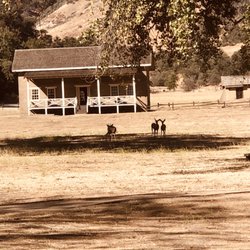
Anyone traveling up to Northern California ( or visa versa) will pass through the grapevine. It's a long grade that humbles semitrucks and cars built in the 80's. If you're lucky enough to travel the grapevine during the day there are some interesting scenic points of interest including pyramid lake. If you're driving in April and May you'll see the yellow and orange flowers during superbloom. - Fort Tejon State Historic Park (spend an hour and stretch your legs) - Lebec Rest Area. CLEAN bathrooms open during pandemic.

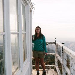
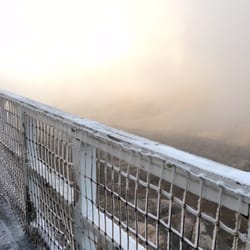
"The Grapevine" I-5 South When I frequently make the I-5 drive to & from Orange County, I reflexively try to check-in as I enter this 40 minute stretch of road. (Approximately one and a half hrs from Magic Mountain; two and a half hrs from the OC; four and a half hrs from the SF Bay Area.) The overall drive can range from six hours to nine, Depending on how fast you drive.) It's one of those highway markers that says, "I made it here!... 'Only ??? miles more to go; depending on your direction & destination. "The Grapevine," also known as Grapevine Hill. (Truth be told, this 40 mile stretch of the I-5 HWY isn't technically called The Grapevine... 'Lucky for me, I never worked IT.) Photo - https://www.yelp.com/biz_photos/the-grapevine-i-5-south-grapevine-2?select=BNjVvL9lzThyneri-1wGSg&userid=O6EBodP3Fgu_n67efSKnBQ Whether you're road trip'n, headed north or south, The Grapevine is always one of those landmark points on the drive. With me, if I'm headed north from South OC, it's my two hour mark out, Magic Mountain being 1 1/2 hr. When I hit the bottom of that hill, I'm about 4-5 hours out until I hit the SF Bay Area and visa versa. When I travel with the HAPA, my bully pit, you can easily add an extra 1-2 hours... 'And if I'm tired, add an extra 3-5 hours. (i.e. - Rest area; sleepy time) Now, entering Grapevine Hil (Southbound) - https://www.yelp.com/biz_photos/the-grapevine-i-5-south-grapevine-2?select=ooqZ3BHnryn1iaX5krjv6A I don't usually make regular stops while passing through Grapevine Hill but if I do, it's usually at the Tejon Pass Safety Roadside Rest Area on my BARTs Northbound. Teton Pass Rest Area (Photo) - https://www.yelp.com/biz_photos/the-grapevine-i-5-north-castaic?select=d_31gMz8KAPhiHS5jY7suQ *BART - Bay Area Road Trip There are two stories that address how the name, The Grapevine, came about: 1. The route resembled that of an actual grapevine. 2. Back in the day, the route was thick with overgrown grapevines and travelers had to literally hack their way through. (I believe this one to be the more accurate of the two.) Whether you make the I-5 road trip once or twice a year or every few months, be safe. If you're feeling tired, pull over @ one of the rest areas. If you're too tired to reach a rest area, find a well lit gas station to stop at and get some sleep. I used to make this drive once every two months before I originally moved to Southern California. It would always sadden me along with a bit of anger whenever I would see a single car, auto accident which most of the time was due to driver fatigue. On a few occasions, there was a blue body bag alongside the totaled, overturned vehicle. (That's a few more than I ever wanted to see.) Idiots. Pull over, take a small nap, wake up, grab a cup of coffee and be on your way. Now, someone's wife, husband, children, or parents are going to get a call @ 3am with the bad news. (Sigh) Safe & smart travels my friends. I created two Yelp*, Grapevine check points, one for northbound travelers and this one, for those headed south. Both are set up @ their "relative entry points" on Grapevine Hill depending on which direction you're driving. Whenever I would make the drive and attempt to check-in @ The Grapevine... (Insert buzzer sound here) 'Nada, nothing, zilch. - "Wrong answer, do not pass GO, do not collect $200, but thank you for playing." So, on this last visit to the SF Bay Area, I thought, "It's time." **Note: Be sure to check weather conditions if you're planning on driving through The Grapevine, severe rain/snow can create road closures not to mention mudslides as of late. (i.e. - Sh'tuck) On this last trip, the weather went from light clouds & sun to thick as molasses fog; followed by heavy rains. Photo - https://www.yelp.com/biz_photos/the-grapevine-i-5-south-grapevine-2?select=koIWLtztzuzjvxXPlAn7jA Local weather - http://www.localconditions.com/weather-grapevine-california/93243/forecast.php The Grapevine (Source: Wikipedia) - https://en.wikipedia.org/wiki/Grapevine,_California - Big Aloha & drive safe! Food: n/a Ambiance: 4 Service: 5+ Value: 5

1 year ago
Review #851 2025-023 What goes up, must come down... right? I oddly reviewed "The Grapevine" I-5 North (refer to Review #247) but didn't comment on the south. LOL It's the return from my happy place where I frequently visit my aunt & uncle, especially meaningful after my parents passing. My son never had the opportunity to meet his great uncle, so he was especially doted on by my aunt. This last visit was to my cousin's, their youngest daughter & it was a very different road trip because my beloved aunt & uncle have joined my parents. I no longer have to pay tuition for my mahjong sessions (because I frequently lose to them), receive hugs & affection, enjoy delish home-cooked comfort foods & soups. I was intentional in my road trips to visit them after I settled in my work schedule; the I-5 South always brings a little heartache when I have to leave. I have yet to see snow until after my kids were born, & finally understood what my uncle meant about the perils of trying to drive through the mountain pass when the roads became icy. On this recent visit to my cousins, it was bittersweet because my Aunt & Uncle are no longer with us. (T-T) And we went up as a family of 4, & returned home as a family of 5, adopted a fur baby (her name is Snow, a Siamese mixed kitten) because my cousin & his wife are helping a family friend control the kitty population near her home by spaying/neutering the feral kittens & their mommas. I repeat what I wrote about its northbound: "Driving through the pass during the holidays can be a nightmare when traffic just stops; careless drivers may misjudge the steep downgrades & sharp turns as well as steep inclines leading to the many accidents on the I-5. And heavy rain or winds, & fog are major weather hazards. :-( But after a good season of rain, the hillsides are lush & bright with vegetation & wildflowers. =) When you're driving through The Grapevine during the winter, rainy months, be sure to check The I-5 weather advisory for any intermittent road closures or to add snow chains if you attempt to drive the pass. The only thing you can still be sure of... you have to yawn, chew gum, or suck on a lollipop to relieve the pressure on your ears." Whether you're coming or going... wish you happy & safe driving folks! read more


 - Landmarks & Historical Buildings Near Me")
 - Landmarks & Historical Buildings Near Me")


This mountain pass links Southern California to the Central Valley. It is commonly referred to as "The Grapevine" and today Interstate 5 comes through. The highest point is 4144 feet. The road is curvy and the grades are steep. But trucks seem to do it just fine. Check the weather before trying. It does snow here and the road can get iced. Be weather aware. [Review 21041 overall - 548 in California - 4 of 2024.] read more

4 years ago
Enjoying the scenery on The Grapevine I-5. The is the route we have always taken when traveling to the Los Angeles area. Traffic is minimal today being a Monday and missing all the weekend traffic. Weather was a bit cloudy but added to the scenery. Wind was minimal and temperatures were in the 60's, not to bad. read more


Anyone traveling up to Northern California ( or visa versa) will pass through the grapevine. It's a long grade that humbles semitrucks and cars built in the 80's. If you're lucky enough to travel the grapevine during the day there are some interesting scenic points of interest including pyramid lake. If you're driving in April and May you'll see the yellow and orange flowers during superbloom. - Fort Tejon State Historic Park (spend an hour and stretch your legs) - Lebec Rest Area. CLEAN bathrooms open during pandemic. read more


2 years ago
9 years ago
"The Grapevine" I-5 South When I frequently make the I-5 drive to & from Orange County, I reflexively try to check-in as I enter this 40 minute stretch of road. (Approximately one and a half hrs from Magic Mountain; two and a half hrs from the OC; four and a half hrs from the SF Bay Area.) The overall drive can range from six hours to nine, Depending on how fast you drive.) It's one of those highway markers that says, "I made it here!... 'Only ??? miles more to go; depending on your direction & destination. "The Grapevine," also known as Grapevine Hill. (Truth be told, this 40 mile stretch of the I-5 HWY isn't technically called The Grapevine... 'Lucky for me, I never worked IT.) Photo - https://www.yelp.com/biz_photos/the-grapevine-i-5-south-grapevine-2?select=BNjVvL9lzThyneri-1wGSg&userid=O6EBodP3Fgu_n67efSKnBQ Whether you're road trip'n, headed north or south, The Grapevine is always one of those landmark points on the drive. With me, if I'm headed north from South OC, it's my two hour mark out, Magic Mountain being 1 1/2 hr. When I hit the bottom of that hill, I'm about 4-5 hours out until I hit the SF Bay Area and visa versa. When I travel with the HAPA, my bully pit, you can easily add an extra 1-2 hours... 'And if I'm tired, add an extra 3-5 hours. (i.e. - Rest area; sleepy time) Now, entering Grapevine Hil (Southbound) - https://www.yelp.com/biz_photos/the-grapevine-i-5-south-grapevine-2?select=ooqZ3BHnryn1iaX5krjv6A I don't usually make regular stops while passing through Grapevine Hill but if I do, it's usually at the Tejon Pass Safety Roadside Rest Area on my BARTs Northbound. Teton Pass Rest Area (Photo) - https://www.yelp.com/biz_photos/the-grapevine-i-5-north-castaic?select=d_31gMz8KAPhiHS5jY7suQ *BART - Bay Area Road Trip There are two stories that address how the name, The Grapevine, came about: 1. The route resembled that of an actual grapevine. 2. Back in the day, the route was thick with overgrown grapevines and travelers had to literally hack their way through. (I believe this one to be the more accurate of the two.) Whether you make the I-5 road trip once or twice a year or every few months, be safe. If you're feeling tired, pull over @ one of the rest areas. If you're too tired to reach a rest area, find a well lit gas station to stop at and get some sleep. I used to make this drive once every two months before I originally moved to Southern California. It would always sadden me along with a bit of anger whenever I would see a single car, auto accident which most of the time was due to driver fatigue. On a few occasions, there was a blue body bag alongside the totaled, overturned vehicle. (That's a few more than I ever wanted to see.) Idiots. Pull over, take a small nap, wake up, grab a cup of coffee and be on your way. Now, someone's wife, husband, children, or parents are going to get a call @ 3am with the bad news. (Sigh) Safe & smart travels my friends. I created two Yelp*, Grapevine check points, one for northbound travelers and this one, for those headed south. Both are set up @ their "relative entry points" on Grapevine Hill depending on which direction you're driving. Whenever I would make the drive and attempt to check-in @ The Grapevine... (Insert buzzer sound here) 'Nada, nothing, zilch. - "Wrong answer, do not pass GO, do not collect $200, but thank you for playing." So, on this last visit to the SF Bay Area, I thought, "It's time." **Note: Be sure to check weather conditions if you're planning on driving through The Grapevine, severe rain/snow can create road closures not to mention mudslides as of late. (i.e. - Sh'tuck) On this last trip, the weather went from light clouds & sun to thick as molasses fog; followed by heavy rains. Photo - https://www.yelp.com/biz_photos/the-grapevine-i-5-south-grapevine-2?select=koIWLtztzuzjvxXPlAn7jA Local weather - http://www.localconditions.com/weather-grapevine-california/93243/forecast.php The Grapevine (Source: Wikipedia) - https://en.wikipedia.org/wiki/Grapevine,_California - Big Aloha & drive safe! Food: n/a Ambiance: 4 Service: 5+ Value: 5 read more


 - Big Aloha! - Landmarks & Historical Buildings Near Me")
 - Landmarks & Historical Buildings Near Me")
 - Landmarks & Historical Buildings Near Me")
 - Landmarks & Historical Buildings Near Me")
9 years ago

8 years ago
More info about "The Grapevine" I-5 South
Ask the Community - "The Grapevine" I-5 South
Review Highlights - "The Grapevine" I-5 South


Why does Yelp recommend reviews?
1 review that is not currently recommended
The reviews below are not factored into the business's overall star rating.
7 years ago
"The Grapevine" I-5 South - landmarks - Updated May 2026
Best of ARVIN
People found "The Grapevine" I-5 South by searching for…
Trending Searches in ARVIN, CA
Botanical Gardens near "The Grapevine" I-5 South
Bounce House Rentals near "The Grapevine" I-5 South
Campgrounds near "The Grapevine" I-5 South
Cherry Picking near "The Grapevine" I-5 South
Cliff Jumping near "The Grapevine" I-5 South
Flower Shop near "The Grapevine" I-5 South
Free Picnic Areas near "The Grapevine" I-5 South
Garden Center near "The Grapevine" I-5 South
Gold Panning near "The Grapevine" I-5 South
Hair near "The Grapevine" I-5 South
Hidden Gems near "The Grapevine" I-5 South
Historic Homes near "The Grapevine" I-5 South
Landmarks & Historical Buildings near "The Grapevine" I-5 South
Nurseries & Gardening near "The Grapevine" I-5 South
Outdoor Furniture Stores near "The Grapevine" I-5 South
Party Equipment Rentals near "The Grapevine" I-5 South
Pedicure near "The Grapevine" I-5 South
Photo Spots near "The Grapevine" I-5 South
Pick Your Own Farms near "The Grapevine" I-5 South
Places To Take Pictures near "The Grapevine" I-5 South
Places To Visit near "The Grapevine" I-5 South
Rv Rental near "The Grapevine" I-5 South
Scenic Restaurants near "The Grapevine" I-5 South
Sightseeing near "The Grapevine" I-5 South
Strawberry Picking near "The Grapevine" I-5 South
Sunset View near "The Grapevine" I-5 South
Browse Articles
Browse Nearby
BEST of ARVIN, California Things to Do near "The Grapevine" I-5 South
BEST of ARVIN, California Restaurants near "The Grapevine" I-5 South
BEST of ARVIN, California Coffee near "The Grapevine" I-5 South
BEST of ARVIN, California Museums near "The Grapevine" I-5 South
BEST of ARVIN, California Hotels near "The Grapevine" I-5 South
BEST of ARVIN, California Breakfast near "The Grapevine" I-5 South
BEST of ARVIN, California Parks near "The Grapevine" I-5 South
BEST of ARVIN, California Sledding near "The Grapevine" I-5 South
BEST of ARVIN, California Campgrounds near "The Grapevine" I-5 South
Browse Brands
Related Searches in ARVIN, CA
Best Fun Things to Do in Arvin, California
Discover Charming Historic Homes in Arvin, California
Discover Famous Monuments in Arvin, California
Discover Historic Sites and Places in Arvin, California
Discover Popular Photo Spots in Arvin, California
Discover Top Points of Interest in Arvin, California
Discover the Best Caves to Explore in Arvin, California
Enjoy Arts & Entertainment in Arvin, California
Enjoy the Best Family Activities in Arvin, California
Enjoy the Best Night View Spots in Arvin, California
Enjoy the Best Walking Trails in Arvin, California
Experience Stunning Sunset Views in Arvin, California
Explore Beautiful Parks and Green Spaces in Arvin, California
Explore Family-Friendly Zoos and Wildlife in Arvin, California
Explore Free Things to Do Around Arvin, California
Explore Fun Activities to Do in Arvin, California
Explore Fun Field Trips in Arvin, California
Explore Nature Spots Around Arvin, California
Explore Popular Scenic Overlook Points in Arvin, California
Explore Popular View Points Around Arvin, California
Explore Secret Spots Worth Visiting in Arvin, California
Explore Top Art Galleries Located in Arvin, California
Explore Venues & Event Spaces in Arvin, California
Find Beautiful Views in Arvin, California
Find Fun Things to Do With Kids in Arvin, California
Find Top Art Museums in Arvin, California
Find Top Libraries to Visit in Arvin, California
Find Top-Rated Waterfalls in Arvin, California Now
Find a Public Library Near You in Arvin, California
Find the Best Playgrounds to Visit in Arvin, California
Fun Things for Kids in Arvin, California
Hiking Trails With Waterfalls in Arvin, California
Must-See Tourist Attractions Around Arvin, California
Popular Outdoor Activities to Try in Arvin, California
Popular Picnic Spots to Visit in Arvin, California
Popular Places to Go in Arvin, California
Popular Places to Take Pictures in Arvin, California
Popular Things to Do in Arvin, California
Popular Things to See in Arvin, California
Top Entertainment Options in Arvin, California
Top Hiking Trails to Explore in Arvin, California
Top Historic Restaurants to Try in Arvin, California
Top Museums for Kids to Visit in Arvin, California
Top Places to Visit in Arvin, California for Sightseeing
Top Things to Do With Kids in Arvin, California
Tour Famous Lighthouses Located in Arvin, California
Visit Beautiful Gardens in Arvin, California
Visit Cultural Centers in Arvin, California
People who viewed "The Grapevine" I-5 South also viewed
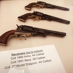
Fort Tejon State Historic Park
50 reviews
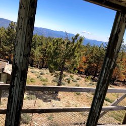
Frazier Mountain Lookout
3 reviews
Tejon Pass Rest Area I-5 NB
32 reviews
$
Mount Pinos Nordic Base
4 reviews
The Old Ridge Route
3 reviews
Pine Mountain Club
22 reviews
Veterans Memorial at Cub Lake
3 reviews
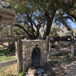
City of Lebec
2 reviews
Lakeview Gusher
1 review
Frazier Park Branch Kern County Library
8 reviews