Sugarite Canyon State Park Photos


You might also consider
More like Sugarite Canyon State Park
Recommended Reviews - Sugarite Canyon State Park
Start your review...

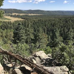
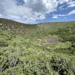
An Afternoon Well Spent !! It has been many years since I've been to the Raton area and typically whenever I was in the area it was just a quick to use the bathroom or get gas. On this visit, it was on a Friday afternoon and I had a few hours to kill and wanted to actually see some of the area. I remembered from years past that there were some lakes up in the mountains that I had always wanted to see and now was my chance. The Park is only about 20 miles from Raton and the roads were not that busy. The drive up is really nice as you see mountains, hills ranches, and some great scenery. On the way to Lake Maloya I stopped at one of the smaller lakes, Lake Alice and spent about half an hour checking it out. There really isn't access to that lake but you can tell its frequented by anglers. It is a nice small scenic lake. I then made my way up to Lake Maloya which is a reservoir for the area and right on the Colorado border. The lake is magnificent!! On a nice warm summer day, there was a nice breeze and no bugs. There were boaters on the lake, some people canoeing and some campers but it was not that busy at all. I spent a good two hours stopping and driving farther up the lake until I came to the gate that takes you to Dorothy Lake ( for another time). The views are just amazing, I suggest bringing a canoe or kayak and spending a good day there. I'm not sure if there is swimming since I didn't see anyone swimming in the water. Next up was Sugarite Canyon, and when you stop at the main entrance they use the honour system where you pay, so please pay!!! I made my way to the visitors center and got a map of the trails. The canyon is a great place to hike and I saw no one else on the trail and felt like I had the place to myself. I can't describe how nice it was walking through the canyon, and all there is to see. I highly recommend hiking with a buddy since it is in a remote area and I saw a few different animal tracks as I made my way through the trails. In short, this area is worth a visit, you can spend a few hours there or a few days, its truly part of the magnificence that is New Mexico. read more


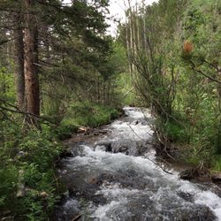
Google know all about this place but not yelp? We are fixing that right now. As the parks service says "The nature enthusiast will appreciate the abundance of wildlife, birds, butterflies, and wildflowers among the lakes, creeks, forests, and meadows. Nearly all outdoor recreation activities are possible: Fishing, boating, hiking, horseback riding, hunting, and camping." All true. This is a huge park. Full of lakes, trails & wildlife. We took a 6 mile loop trail starting at the dam yesterday and saw NO ONE else. Lots of scat indicate there lots of moose and bear around, so be aware. There are numerous other trails as well add the aforementioned activities. Definitely worth a visit if you're in the area. read more


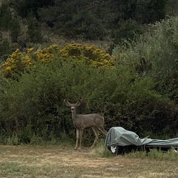
My wife and I have been camping all over New Mexico and Sugarite State Park is becoming one of our favorite places to go. The camp sites are small but private due to the abundant vegetation including choke cherry bushes. There are two camp grounds, Lake Alice the one we stay at and Soda Pocket. Lake Alice had full hook ups where as Soda Pocket is dry camping. The drive from Raton to the camp grounds should be taken seriously for all of the wildlife sightings. There are bear,Mule deer, and turkey sightings to be had by the careful viewer. The camp host, Ben Old, told us this trip that there was a sighting of a snipe. If there's one, you know there's more. There are two lakes where you can fish, Lake Alice and Lake Maloya. Hats off to all State Park employees for the care they take in providing us with such a wonderful State Park. And many thanks to the two camp hosts that do a meet and greet when you arrive. They can also provide you with wonderful day trip information. Enjoy and Happy Camping!! read more


More info about Sugarite Canyon State Park
NM-526
Raton, NM 87740
Directions
(575) 445-5607
Call Now
Hours
Outdoor Amenities
Other Amenities


Sugarite Canyon State Park - hiking - Updated August 2026
Best of Raton
People found Sugarite Canyon State Park by searching for…
Trending Searches in Raton, NM
Browse Articles
Browse Nearby
Browse Brands
Related Cost Guides
Related Searches in Raton, NM
Affordable Lodging Options in Raton, New Mexico
Best Fishing Locations and Guides in Raton, New Mexico
Best Nature Trails for Hiking in Raton, New Mexico
Best Places for Horseback Riding in Raton, New Mexico
Best Sledding Spots and Fun in Raton, New Mexico
Best Spots for Star Gazing in Raton, New Mexico
Best Waterfalls and Swimming Holes in Raton, New Mexico
Browse Top Hotels in Raton, New Mexico for Your Stay
Browse Vacation Rentals to Book in Raton, New Mexico
Check Out Great Playgrounds in Raton, New Mexico
Check Out Off Road Trails in Raton, New Mexico
Discover Free Campgrounds in Raton, New Mexico Area
Discover Lakes & Ponds to Explore in Raton, New Mexico
Discover Popular Bike Trails in Raton, New Mexico
Discover Popular Photo Spots in Raton, New Mexico
Discover Top Nature Parks to Visit in Raton, New Mexico
Discover a Hiking Trail in Raton, New Mexico
Discover the Best Beaches in Raton, New Mexico
Enjoy Arts & Entertainment in Raton, New Mexico
Enjoy Camping Adventures Around Raton, New Mexico
Enjoy Exciting Mountain Biking Adventures in Raton, New Mexico
Enjoy Hiking Adventures in Raton, New Mexico
Enjoy Kayaking Adventures in Raton, New Mexico
Enjoy Tent Camping Spots Around Raton, New Mexico
Enjoy a Relaxing Bed & Breakfast Experience in Raton, New Mexico
Enjoy the Best Picnic Spots and Ideas in Raton, New Mexico
Enjoy the Best Tubing Experiences in Raton, New Mexico
Enjoy the Best Walking Trails in Raton, New Mexico
Experience Stunning Sunset Views in Raton, New Mexico
Explore Beautiful Parks and Green Spaces in Raton, New Mexico
Explore Hotels & Travel Options in Raton, New Mexico
Explore Kid Friendly Places and Events in Raton, New Mexico
Explore Landmarks & Historical Buildings in Raton, New Mexico
Explore Mobile Home Parks in Raton, New Mexico Now
Explore Picnic Parks Near Raton, New Mexico
Explore Popular Campgrounds Near Raton, New Mexico
Explore Popular Picnic Areas Around Raton, New Mexico
Explore Popular RV Parks Around Raton, New Mexico
Explore Popular Scenic Overlook Points in Raton, New Mexico
Explore Popular Scenic Views Near Raton, New Mexico
Explore Popular View Points Around Raton, New Mexico
Explore Scenic Lakes to Visit in Raton, New Mexico
Explore Top Gyms in Raton, New Mexico Now
Explore Venues & Event Spaces in Raton, New Mexico
Family Friendly Hiking With Kids in Raton, New Mexico
Find Beautiful Views in Raton, New Mexico
Find Cozy Camping Cabins in Raton, New Mexico
Find Exciting Tours to Take in Raton, New Mexico
People who viewed Sugarite Canyon State Park also viewed
Trinidad Lake State Park
20 reviews
Climax Canyon
3 reviews
Raton Pass Camp
21 reviews
NRA Whittington Center
8 reviews
Capulin Camp & RV Park
14 reviews
Cawthon RV Park and Motel
2 reviews
Capulin Volcano National Monument
48 reviews
Simpson's Rest
2 reviews
Raton Regional Aquatic Center
2 reviews
Cougar Canyon Golf Resort Community
1 review