Cancel

Open app

Search

Sooke River Trail

5.0 (1 review)

Sooke River Trail Photos

Sooke River Trail Reviews in Other Languages

Verify this business for free

Get access to customer & competitor insights.

Verify this business

Sooke Potholes Provincial Park - Map from P2.

Sooke Potholes Provincial Park

4.6(9 reviews)
4.0 km

This place is nothing short of breath-taking. Why? So scenic, and you don't have to break the…read morebody to get to it. What I mean by that is this. I fully expected to hike a fair distance to see the best of the best. But a good Samaritan took pity on me whilst looking at the map in the parking lot and gave me some valuable advice. He was there with his wife about to embark on some serious hiking from what I could see. Why was it valuable advice? Because the map was like trying to decipher a rubics cube. This man took all the guesswork away and cut to the chase to what I'm calling the Sweet Spot for viewing. Start at P lot 3, go to the end of the p lot to find the entrance of a trail. Go to the right to get on the trail, and veer for routes to the left, which are closest to the water. You will come to spectacular views of the potholes; high above, so be careful. There are no fences or ropes, so I can not stress more. Be uber careful. But so beautiful. And so much joy for so little work. Meaning I didn't have to walk far to be so richly rewarded. These pics are what I took, but do not do the experience justice. They don't show depth. You just gotta go and experience it for yourself. If I ever see that man again, I'd buy him a bottle of wine. He was a Godsend. I guess the best I can do now not knowing who he was, is a big fat thank you here. And hope he's a Yelper.

This place is super confusing!! I wish this park was labeled a bit more cause it was hard to find…read morepotholes that you can actually swim in! First off, please park on lot #2 for best route to the potholes. When you're there, head to Peddle Beach for a small peddle beach. You see a pothole that folks can lay around and swim in. You will see another trail that leads to the potholes. It's about a two minute walk to the what you'll see in my pictures. To the potholes, there are one or two other potholes too you can swim in. In my pictures, that's the place you want to go to. In there, there are rocks for to camp up at and you can swim In the shallow ends or in the deep ends. There are multiple holes that are available for you to pick from. The hard part is walking on the rock formulation cause it can hurt a bit and can be slippery cause of the water. And the water is COLD! But of course, when you're in, you'll be fine. You can walk around the trail, I don't remember the name, I think it was Water Trail? But it's just a trail for hikers. There is a PotHoles View Point and it is just to view these rapid potholes. There were some teenagers that said that you can hope the fence to go down. It look super sketchy, so we didn't go down with them. You can't really float down there given how rapid the water was going. When you first get into the park, there is an initial parking lot that doesn't require you to pay. You can swim and lay around there too. We noticed that it's mainly for kids so it can get crowded. Parking was pretty crowded when we leave, so get there early to avoid walking too far. Parking lot is $2.25 until sunset. It was a great park but so confusing!! Most of the people that we talked about the way were just as confused.

Photos
Sooke Potholes Provincial Park - Map at P3

Map at P3

Sooke Potholes Provincial Park

See all

West Coast Outdoor Adventure Rentals - Rent a Stand Up PaddleBoard (SUP) and take it anywhere you wish to explore!

West Coast Outdoor Adventure Rentals

4.9(17 reviews)
3.4 km

I took my boyfriend out to Sooke to rent Hobie kayaks and we had a blast!…read more Allen gave us great suggestions about where we should pedal around and thoroughly explained how to use the kayaks. He outfitted us with everything we would need including a banana to snack on! I felt completely safe the entire time even though I'd been nervous going into it and my boyfriend still felt like he'd had an adventure. We're both from the prairies so seeing sea stars, seals, crab, eagles, and even boats was pretty exciting for us. Excellent fun and we plan to do it again!

My mom and I rented a kayak and went on a guided tour with Allen. It was a wonderful experience!…read moreAllen was informative about the area and shared many stories with us as we peddled around Sooke. The kayaks were comfortable and easy to use. My mom and I were not great at using the oars but Allen was patient and gave us tips to help us! He was entertaining and taught us how to use kelp as a horn! We saw lots of wildlife including some cute seals that we got really close to! We highly recommend this incredible experience to all adventurers and recommend that you go with a guided tour as you will learn much more and get to see more! Thanks for an awesome time, Allen!

Photos
West Coast Outdoor Adventure Rentals - Hobie Tandem Island Rentals & Tours

Hobie Tandem Island Rentals & Tours

West Coast Outdoor Adventure Rentals - Stand Up PaddleBoards (SUP) & Hobie kayak Rentals

Stand Up PaddleBoards (SUP) & Hobie kayak Rentals

West Coast Outdoor Adventure Rentals - Packages available with local Hotels and Resorts (Prestige Oceanfront Resort, Sooke shown)

See all

Packages available with local Hotels and Resorts (Prestige Oceanfront Resort, Sooke shown)

Olympic Hot Springs - Log bridge over a creek.

Olympic Hot Springs

3.6(28 reviews)
42.2 km

Firstly, several of these reviews are for the wrong hot springs. If a review mentions a restaurant,…read moreor a resort, or a time slot, they are referring to the SOL DUC hot springs, not these ones. Also, the reviews that mention that the hike is easy are all outdated! It's a slog to get there! The Olympic hot springs are a 12 mile hike mostly uphill. It used to be a much shorter hike but about five years ago the road washed out and you now have to hike an extra 8 miles... 12 miles total... one way. It's a slog! The springs themselves, while pretty, are shallow, muddy, slimy, and overall pretty gross. The signs warn of fecal bacteria. If you're hoping to hike 12 miles to soak in pristine pools, think again. Nudity is common. If anyone is actually using the hot springs, they will likely be nude. Get over it!! Let the nudists have their place... and 12 miles deep in the woods is a nice place to be nude. You might also see nudists hiking or biking on the trail to the hot springs. It's not common but does happen occasionally. Just smile and say hi! The hike starts off easy on a paved road for about 3/4 of a mile. Then you have to use a single-track dirt bypass trail that is steep and rooty. If you're using a bike you'll be pushing and carrying it over things. Then you're put back on an old paved road again. It's another 2 miles to the Glines Canyon overlook which is fun to see. Then it's another 5 miles on the same road, but now 100% uphill and sometimes steep, just to reach the trailhead. Once at the trailhead, you're already over 8 miles into it and you have another 2.5 or so to hike... bikes not allowed. You have to park at the Madison Falls parking lot. You're supposed to have a National Park pass.

Enchanted springs in enchanted forest, I have camped here quiet a bit when in college…read more Most special hot springs on earth to me. Hike is fun not too strenuous

Photos
Olympic Hot Springs - Mileage once at the trailhead. This is AFTER already hiking over 8 miles uphill.

Mileage once at the trailhead. This is AFTER already hiking over 8 miles uphill.

Olympic Hot Springs - Hot Spring

Hot Spring

Olympic Hot Springs - Bear warning!

See all

Bear warning!

Sol Duc Falls - Falls trail

Sol Duc Falls

4.8(36 reviews)
49.7 km

This is a lovely hike, about a mile each way to the falls. I personally found it pretty easy, but…read moreif you have less stamina or arthritis (ie my mother), it's a little challenging. Nevertheless - she was able to do it ok! She just had to stop for a couple breaks along the way. The entire trail is very scenic, there are many cool trees and vegetation plus streams and little bridges along the way, so great for pics! The falls are ofc magical as well. PLEASE heed the park sign's warnings and don't climb the railings, it's so dangerous :( people have gotten killed doing that. But if you keep to where you're supposed to, this trail is absolutely very safe :) The car park is a good size. I came on a Tuesday around 8am, and we had no trouble getting a spot, but this is a famous trail: we noticed on the way out that there were no spots left. Someone immediately took ours when we drove off, so plan accordingly! And ofc they have some NPS bathrooms available here, glorified portapotties in the little cubicle rooms, and hand sanitizer available but no running water.

The hike to Sol Duc Falls was another enjoyable hike that I did while visiting Olympic National…read morePark. Sol Duc Valley in Olympic National Park is a pretty area that has towering evergreens. The Sol Duc Hot Springs Resort is also in this valley. The Sol Duc Trail to the falls is a two-mile drive from the resort and is a easy hike to do. The trail itself is less than a mile long and is shaded with a dense forest canopy. After you cross over a small stream on a bridge, you will see the waterfall tumbling over moss-covered rocks. There are many ways to view Sol Duc Falls. It splits into four channels that cascades 48-feet into a narrow canyon. At certain times of the day, you can see rainbows in the mist surrounding the falls. I was able to take photos of many angles of these falls with my camera. I just wished I had my tripod with me. After spending time here at Sol Duc Falls, you have the option to continue your hike to Deer Lake or turn around and go back to the parking lot.

Photos
Sol Duc Falls - Instagram: @telephonesmoothie

Instagram: @telephonesmoothie

Sol Duc Falls - Instagram: @telephonesmoothie

Instagram: @telephonesmoothie

Sol Duc Falls - Instagram: @telephonesmoothie

See all

Instagram: @telephonesmoothie

mount work

mount work

4.0(2 reviews)
24.2 km

Oof, what a hike! I went to the Summit and back from the north parking lot, so about 2km each…read moredirection. There is not an elevation profile of the trail on the trailhead map which seems a shortcoming here. I'm not sure if this one is typical of BC or not but it surprised me how much straight up and straight down was on this trail. I'm used to a lot more switchbacks in Colorado. The uphill was tough but manageable, though not many people yielded as they were coming down. On the way down I figured out why. This trail is BRUTAL on the downhill. There's so much constant down that knees and quads are working constantly and the muscle fatigue around the halfway point was alarming. I wish I'd had hiking poles. Yeah, your experience will vary wildly depending on your personal level of ability. Stay within your limits and keep in mind that down is every bit as tough as up, if not more so, depending on how creaky your joints are. The area is beautiful and the mud was very manageable after a few days of dry weather. Make sure to walk through the mud - there were many areas where people had tramped a lot of vegetation around mud. There were many tracks of mountain bikers using the trail even though they are not supposed to be on the summit trail, so stay aware and able to bail off in an encounter.

A quick hike to the summit about 2.5km each way with steady incline. Most of it is in the shade…read moreuntil the last bit but you get some amazing views! The view is better just before getting to summit. Value 5/5 Atmosphere 5/5 Service 4/5 Quality 4/5 18/20

Photos
mount work
mount work
mount work

See all

Avatar Grove

Avatar Grove

4.7(3 reviews)
59.1 km

"Ye ghosts of all the dear old trees, The oak, the elm, the ash, Nightly those gentlemen go tease,…read moreWho hew you down like trash." It's like if a menthol punch of freshness sensation would hit the deepest nook of your lungs. That first inhalation provides you with an instant invigoration. What better medicine than nature's air cleaning the toxic waist passing through your veins. Your muscles shaking away negativity will give you an instant mood booster, the oxygen modifying every molecule in your body, a shiver that reconnects you with the source, or in Carr's words "...the God in you responding to the God in them". Welcome to a real "Pandora", an almost intact landscape of natural monuments in where the heaviness of the branches will hold wind's melodies. My neck hurt at times when trying to reach by sight the top of these enchanted trees. Once surrounded by that foggy green darkened reality, I understood why some fairy tales were inspired by forests. It's unavoidable to feel observed, every step felt as trespassing, as if I was intruding a sacred space. I tried to understand Carr's perspective, why trees became her obsession until she exhaled them. Every tree had a personality, some of the roots' shapes reminded me of "Pan's Labyrinth", would those muddy holes take me to other realms? The shadows created obscure introspections, the ambivalence of existence, as above as below, a darker interpretation of nature. Some trees languished and perished long time ago, their remains acting as a pillar for new sprouts of life; moss, younger trees, mushrooms, bushes, they all use the elements of the fallen one to continue life's cycle. 
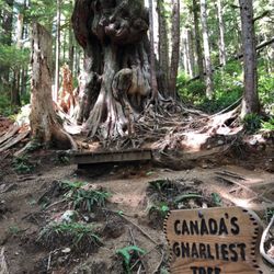
The Gnarliest Tree in Canada might be the star, with a conjugation of shapes resembling multiple fists, all kind of stumps appearing to flow in circles, as if its circumference was formed by dozens of human extremities piled towards and unreachable sky. Come hike to realize how tiny, irrelevant and forgettable you are. We all should play to be forest Rangers, deep thank you to the First Nations and Ancient Forest Alliance for standing against logging in this area.

I can believe the hidden gems this world has to offer. I never thought after driving on a rough…read moredirt road in the middle of nowhere would lead to such an amazing place. Don't get discouraged by the road a car can make it. We saw lots of them up there. The journey is well worth it.

Photos
Avatar Grove - Absolutely stunning!!!

Absolutely stunning!!!

Avatar Grove - These trees are amazing

These trees are amazing

Avatar Grove

See all

Sooke River Trail - hiking - Updated May 2026

Loading...
Loading...
Loading...