Sandia Mountains Photos


More like Sandia Mountains
Recommended Reviews - Sandia Mountains
Start your review...

Reviews With Photos

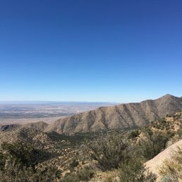
Seeing the Sandía Mountains and hiking them/ climbing them, were always part of my bucket list, but driving through I-25 was just as nice. I saw them on my way to Las Cruces, NM. We are currently 4 hours away from Albuquerque as we speak but they are massive rocks! I saw houses on the bottom of the foothills. I could Imagine how cool it would be to wake up to these beautiful views every morning.

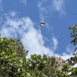
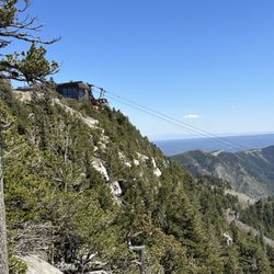
Great views from the mountains and even through the TRAM journey most people go to the top. There is a 6-mile hike too that takes 6-7 hours in total to climb mountains but definitely, we were not the ones to choose that option. TRAM takes 15 minutes for each side to go up or down. The view from the mountains is beautiful and loved it. The only reason to reduce one star is that they don't have a to-go type of restaurant. The one is there is a dine-in place and usually with a long wait time if you have not reserved. I would really love to have some or other quick food options on the top.

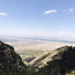
I'm newly arrived in New Mexico, and I was really excited to come check-out the Sandia Mountains. There just aren't that many places in the US that have such BIG mountain peaks right next to a large city. Tip: Drive the road up to the Crest on the East side; there's a parking lot on the left that contains the trail heads for multiple trails. There's are also restrooms available here. The Tree Spring Trail will get you to the peak, where you'll experience a truly unforgettable, panoramic view of Albuquerque. Be forewarned - there are significant winds at the top, and the temperature can be a lot cooler, but the views and the experience of the hike are totally worth it! Along with a good hike and the fantastic views, we even saw some deer and other wildlife. It's fantastic to find myself living this close to Mother Nature at her best - I'll be back!

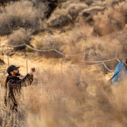
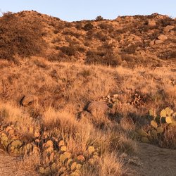
Background: I solo-hiked for ~5 miles to the peak. Started out on and finished the Pino Trail, transitioned onto the Crest Trail which f-ed me over, got lost for a while, followed the 10K, hiked below the ski-lifts (not a path) to the peak/tram house while people from the ski-lifts looked at me like I was amazon woman or something. Pino Trail: -Despite what AllTrails says, this trail is harder than a "moderate" difficulty level. Aside from being lengthy with elevation, the trail was also super uneven. -I had to literally climb over a few trees blocking the path, and also was almost stuck inbetween some random big rocks (thank god I didn't eat an extra carne adovada burrito before coming). Crest Trail: -Somewhere in the middle this terribly marked labyrinth branches into multiple paths at multiple points, which completely f***'s you over if you're looking to get to the tram house -The crest peak has a great view but is hella windy, hold on to your toddlers so they don't mary-poppins away. 10K: -One of the most well-marked and smooth trails, albeit very narrow path Ski-lift: -Not really a trail, but follow the second set of ski-lifts up the grassy hill and you'll be at the peak -Pretty steep and surprisingly exhausting to hike; and people from ski-lifts may look at you from above strangely.

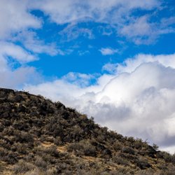
For anyone who has time to spend at least a full day in Albuquerque, the Sandia Mountains are well worth visiting. A tram ride will give you a spectacular view at the summit in all directions. There are lots of great hiking trails at the summit. For those who don't have the time for the tram ride (and for those who do), be sure to check out the mountains as the sun sets. It's a spectacular site to see as the colors of the mountain range change from gray to watermelon and back to gray. All this happens in a matter of minutes... so it pays to get situated well in advance with your camera ready to fire of a few shots. Some believe that the Sandia mountain range get its name the Spanish translation ("watermelon").
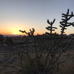
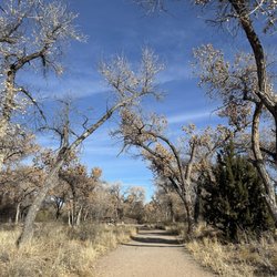
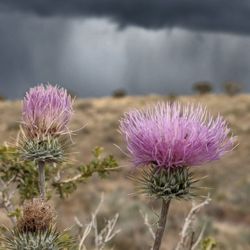
The Sandia Mountains are the perfect backdrop to Albuquerque. They provide stunning visuals for everyone in the city, especially in the evening when they turn a dark shade of red. More importantly, the Mountains provide unlimited exercise and exploration potential. I have only gone on two Sandia Mountain hikes, but they were both excellent quality. The first hike was a hike along the ridge after driving to the top. On our drive up, we saw a group of mule deer crossing the road. The second hike started near the base of the mountain and headed to the top. We did not make the top, but it was fascinating to see the different plants at each altitude. Near the bottom it was mainly dessert brush with minimal vegetation and also an unusually high amount of broken glass. Our trailhead must've also been a favorite hangout for the local teenagers. Farther up the trail the terrain slowly transitioned into taller and taller pine trees. If I lived in Albuquerque, the Sandia Mountains would be a frequented destination.

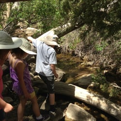
The Sandias are wonderful to look at in Albuquerque and are a marvelous place to hike and spend time in nature. We hiked at the Cienega Canyon picnic ground on our way up, then hiked a bit more at the crest. If you have an hour or two, I highly recommend at least driving up to the crest and taking in the beautiful views.

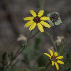
One of my absolute favorite places to hike, especially in the autumn, when the leaves are a gorgeous gradient of red, orange, and yellow hues. The views are breathtaking, with many opportunities to glance over the cliff from the Crest Trail. It gets a little chilly this time of year, so a jacket is typically a must (unless you're a brisk hiker and move fast). I initially came here as part of a class at the University of NM, but ended up loving it so much, I had to return on my own. I've since taken the tram up ($20 round-trip for those under 20), and also taken the ski-lift up ($12/round trip) and both were very enjoyable, in their own respects. Now, I must say, if you have to try the restaurant at the top of the peak, for the "experience," then do it. But don't expect the top of the line restaurant material from up there... there's a reason why their reviews are relatively low. It's just mediocre food. You're paying mainly for the experience, of eating at the top of the Sandia, if anything. My friend paid $12 for an O-K turkey sandwich meal. Definitely coming back when it starts snowing this winter, for the views, however.

Always a gorgeous view as you start to make your way up the Sandias. I've taken the tram up, as well as hiking La Luz and there's no wrong way to do it. There's not many places in the USA where there is such an enormous mountain right next to a large city. Take advantage of the many things that the Sandia Mountains offer you. You can even grab a bite to eat and a drink at the top. Notes: Bring a jacket even if it's hot outside, the temperature at the top of the mountain is much cooler than it is in ABQ. Bring some water and a snack. If you're hiking up the mountain good footwear is absolutely necessary.

I came to Albuquerque to see my son over Thanksgiving weekend. One of the things u wanted to do was hike in the Sandias. My son took me to the Embudito trail. I'm in pretty decent shape for a 57 year old. I bike over 2,000 miles each summer. Coming from Ohio, I wasn't ready for the altitude change. Let me tell you, that trail kicked my butt. It did provide me with beautiful vistas and I liked the three "zones" of the trail. My favorite zone was when we hit the coniferous zone. I think before I go back, I'll mix in some stair master with the biking.

Hiked the Piedra Lisa trail this morning. It is a good steady uphill climb, but you are rewards with views into the mountains and back towards the city the whole way up the trail. The views from the top are superb. We went at 7:30 and there were already a number of people on the trail. It was getting really busy as we were on our way back down.

1 year ago
Such a treasure of the Southwest! I've spent countless hours hiking the foothills and along the rim and the views never get old! A true gem of our city! read more


4 months ago
They have several trails to choose from 5 dollar a day for parking pass and they have picnic areas had a few bathrooms really nice scenery and good for bikes or hiking read more
Seeing the Sandía Mountains and hiking them/ climbing them, were always part of my bucket list, but driving through I-25 was just as nice. I saw them on my way to Las Cruces, NM. We are currently 4 hours away from Albuquerque as we speak but they are massive rocks! I saw houses on the bottom of the foothills. I could Imagine how cool it would be to wake up to these beautiful views every morning. read more


Great views from the mountains and even through the TRAM journey most people go to the top. There is a 6-mile hike too that takes 6-7 hours in total to climb mountains but definitely, we were not the ones to choose that option. TRAM takes 15 minutes for each side to go up or down. The view from the mountains is beautiful and loved it. The only reason to reduce one star is that they don't have a to-go type of restaurant. The one is there is a dine-in place and usually with a long wait time if you have not reserved. I would really love to have some or other quick food options on the top. read more


1 year ago
8 years ago
I'm newly arrived in New Mexico, and I was really excited to come check-out the Sandia Mountains. There just aren't that many places in the US that have such BIG mountain peaks right next to a large city. Tip: Drive the road up to the Crest on the East side; there's a parking lot on the left that contains the trail heads for multiple trails. There's are also restrooms available here. The Tree Spring Trail will get you to the peak, where you'll experience a truly unforgettable, panoramic view of Albuquerque. Be forewarned - there are significant winds at the top, and the temperature can be a lot cooler, but the views and the experience of the hike are totally worth it! Along with a good hike and the fantastic views, we even saw some deer and other wildlife. It's fantastic to find myself living this close to Mother Nature at her best - I'll be back! read more


Background: I solo-hiked for ~5 miles to the peak. Started out on and finished the Pino Trail, transitioned onto the Crest Trail which f-ed me over, got lost for a while, followed the 10K, hiked below the ski-lifts (not a path) to the peak/tram house while people from the ski-lifts looked at me like I was amazon woman or something. Pino Trail: -Despite what AllTrails says, this trail is harder than a "moderate" difficulty level. Aside from being lengthy with elevation, the trail was also super uneven. -I had to literally climb over a few trees blocking the path, and also was almost stuck inbetween some random big rocks (thank god I didn't eat an extra carne adovada burrito before coming). Crest Trail: -Somewhere in the middle this terribly marked labyrinth branches into multiple paths at multiple points, which completely f***'s you over if you're looking to get to the tram house -The crest peak has a great view but is hella windy, hold on to your toddlers so they don't mary-poppins away. 10K: -One of the most well-marked and smooth trails, albeit very narrow path Ski-lift: -Not really a trail, but follow the second set of ski-lifts up the grassy hill and you'll be at the peak -Pretty steep and surprisingly exhausting to hike; and people from ski-lifts may look at you from above strangely. read more


For anyone who has time to spend at least a full day in Albuquerque, the Sandia Mountains are well worth visiting. A tram ride will give you a spectacular view at the summit in all directions. There are lots of great hiking trails at the summit. For those who don't have the time for the tram ride (and for those who do), be sure to check out the mountains as the sun sets. It's a spectacular site to see as the colors of the mountain range change from gray to watermelon and back to gray. All this happens in a matter of minutes... so it pays to get situated well in advance with your camera ready to fire of a few shots. Some believe that the Sandia mountain range get its name the Spanish translation ("watermelon"). read more

The Sandia Mountains are the perfect backdrop to Albuquerque. They provide stunning visuals for everyone in the city, especially in the evening when they turn a dark shade of red. More importantly, the Mountains provide unlimited exercise and exploration potential. I have only gone on two Sandia Mountain hikes, but they were both excellent quality. The first hike was a hike along the ridge after driving to the top. On our drive up, we saw a group of mule deer crossing the road. The second hike started near the base of the mountain and headed to the top. We did not make the top, but it was fascinating to see the different plants at each altitude. Near the bottom it was mainly dessert brush with minimal vegetation and also an unusually high amount of broken glass. Our trailhead must've also been a favorite hangout for the local teenagers. Farther up the trail the terrain slowly transitioned into taller and taller pine trees. If I lived in Albuquerque, the Sandia Mountains would be a frequented destination. read more


The Sandias are wonderful to look at in Albuquerque and are a marvelous place to hike and spend time in nature. We hiked at the Cienega Canyon picnic ground on our way up, then hiked a bit more at the crest. If you have an hour or two, I highly recommend at least driving up to the crest and taking in the beautiful views. read more


One of my absolute favorite places to hike, especially in the autumn, when the leaves are a gorgeous gradient of red, orange, and yellow hues. The views are breathtaking, with many opportunities to glance over the cliff from the Crest Trail. It gets a little chilly this time of year, so a jacket is typically a must (unless you're a brisk hiker and move fast). I initially came here as part of a class at the University of NM, but ended up loving it so much, I had to return on my own. I've since taken the tram up ($20 round-trip for those under 20), and also taken the ski-lift up ($12/round trip) and both were very enjoyable, in their own respects. Now, I must say, if you have to try the restaurant at the top of the peak, for the "experience," then do it. But don't expect the top of the line restaurant material from up there... there's a reason why their reviews are relatively low. It's just mediocre food. You're paying mainly for the experience, of eating at the top of the Sandia, if anything. My friend paid $12 for an O-K turkey sandwich meal. Definitely coming back when it starts snowing this winter, for the views, however. read more


Always a gorgeous view as you start to make your way up the Sandias. I've taken the tram up, as well as hiking La Luz and there's no wrong way to do it. There's not many places in the USA where there is such an enormous mountain right next to a large city. Take advantage of the many things that the Sandia Mountains offer you. You can even grab a bite to eat and a drink at the top. Notes: Bring a jacket even if it's hot outside, the temperature at the top of the mountain is much cooler than it is in ABQ. Bring some water and a snack. If you're hiking up the mountain good footwear is absolutely necessary. read more


8 years ago
I came to Albuquerque to see my son over Thanksgiving weekend. One of the things u wanted to do was hike in the Sandias. My son took me to the Embudito trail. I'm in pretty decent shape for a 57 year old. I bike over 2,000 miles each summer. Coming from Ohio, I wasn't ready for the altitude change. Let me tell you, that trail kicked my butt. It did provide me with beautiful vistas and I liked the three "zones" of the trail. My favorite zone was when we hit the coniferous zone. I think before I go back, I'll mix in some stair master with the biking. read more


6 years ago
Hiked the Piedra Lisa trail this morning. It is a good steady uphill climb, but you are rewards with views into the mountains and back towards the city the whole way up the trail. The views from the top are superb. We went at 7:30 and there were already a number of people on the trail. It was getting really busy as we were on our way back down. read more


11 years ago
Very beautiful. Went with a friend we hiked up and down two mountains. Took us about 4.5 hours. Very beautiful area looked about the tramway the ski lifts, the sandia house. Everything was green and lovely. read more


13 years ago
More info about Sandia Mountains
The Skyline Of The 505
Albuquerque, NM 87122
Eastside
Directions
Hours
Outdoor Amenities
Ask the Community - Sandia Mountains
Review Highlights - Sandia Mountains


Sandia Mountains - hiking - Updated July 2026
Best of Albuquerque
People found Sandia Mountains by searching for…
Things to Do in Albuquerque, New Mexico
Sunset View in Albuquerque, New Mexico
Scenic View in Albuquerque, New Mexico
Hiking Trails With Waterfalls in Albuquerque, New Mexico
Picnic Areas in Albuquerque, New Mexico
Attractions in Albuquerque, New Mexico
Night View in Albuquerque, New Mexico
Parks in Albuquerque, New Mexico
Tours in Albuquerque, New Mexico
Off Road Trails in Albuquerque, New Mexico
Photo Spots in Albuquerque, New Mexico
Walking Trails in Albuquerque, New Mexico
Beautiful Views in Albuquerque, New Mexico
View Points in Albuquerque, New Mexico
Watch Sunset in Albuquerque, New Mexico
Waterfalls in Albuquerque, New Mexico
Easy Hiking Trails in Albuquerque, New Mexico
Running Trails in Albuquerque, New Mexico
Trails in Albuquerque, New Mexico
Scenic Overlook in Albuquerque, New Mexico
Canyoneering in Albuquerque, New Mexico
Natural Hot Springs in Albuquerque, New Mexico
Trending Searches in Albuquerque, NM
Boat Rental near Sandia Mountains
Cliff Jumping near Sandia Mountains
Day Trips near Sandia Mountains
Dog Friendly Trails near Sandia Mountains
Dog Swimming near Sandia Mountains
Fishing Spots near Sandia Mountains
Kayak Rental near Sandia Mountains
Off Road Trails near Sandia Mountains
Outdoor Activities near Sandia Mountains
Places To Walk Around near Sandia Mountains
Pool Day Pass near Sandia Mountains
Public Pools near Sandia Mountains
Public Shower near Sandia Mountains
River Swimming near Sandia Mountains
River Tubing near Sandia Mountains
Rock Quarry near Sandia Mountains
Running Trails near Sandia Mountains
Scenic Night View near Sandia Mountains
Soccer Store near Sandia Mountains
Strawberry Picking near Sandia Mountains
Sunrise View near Sandia Mountains
Swimming Holes near Sandia Mountains
Swimming Lakes near Sandia Mountains
Watch Sunset near Sandia Mountains
Browse Articles
Browse Nearby
BEST of Albuquerque, New Mexico Restaurants near Sandia Mountains
BEST of Albuquerque, New Mexico Coffee near Sandia Mountains
BEST of Albuquerque, New Mexico Parks near Sandia Mountains
BEST of Albuquerque, New Mexico Things to Do near Sandia Mountains
BEST of Albuquerque, New Mexico Lakes near Sandia Mountains
BEST of Albuquerque, New Mexico Breakfast near Sandia Mountains
BEST of Albuquerque, New Mexico Campgrounds near Sandia Mountains
BEST of Albuquerque, New Mexico Ski Resorts near Sandia Mountains
Browse Brands
Related Searches in Albuquerque, NM
Affordable Kayak Rental Services in Albuquerque, New Mexico
Best Dog Hiking Trails Around Albuquerque, New Mexico
Best Fishing Locations and Guides in Albuquerque, New Mexico
Best Places for Horseback Riding in Albuquerque, New Mexico
Best Sightseeing Experiences Available in Albuquerque, New Mexico
Check Out Off Road Trails in Albuquerque, New Mexico
Discover Dog Friendly Trails to Explore in Albuquerque, New Mexico
Discover Easy Hiking Trails Near Albuquerque, New Mexico
Discover Popular Bike Trails in Albuquerque, New Mexico
Discover a Hiking Trail in Albuquerque, New Mexico
Discover the Best Night Hike Trails in Albuquerque, New Mexico
Dog-Friendly Hikes With Dogs in Albuquerque, New Mexico
Enjoy Camping Adventures Around Albuquerque, New Mexico
Enjoy Kayaking Adventures in Albuquerque, New Mexico
Enjoy Off Leash Dog Hikes in Albuquerque, New Mexico
Enjoy Scenic Places to Walk in Albuquerque, New Mexico
Enjoy Tent Camping Spots Around Albuquerque, New Mexico
Enjoy the Best Walking Trails in Albuquerque, New Mexico
Experience Stunning Sunset Views in Albuquerque, New Mexico
Explore Beautiful Parks and Green Spaces in Albuquerque, New Mexico
Explore Easy Hikes Perfect for All in Albuquerque, New Mexico
Explore Fun Activities to Do in Albuquerque, New Mexico
Explore Popular Campgrounds Near Albuquerque, New Mexico
Explore Scenic Lakes to Visit in Albuquerque, New Mexico
Explore Top Dog Parks in Albuquerque, New Mexico Near You
Family Friendly Hiking With Kids in Albuquerque, New Mexico
Find Beautiful Views in Albuquerque, New Mexico
Find Cozy Camping Cabins in Albuquerque, New Mexico
Find Parks and Recreation Activities in Albuquerque, New Mexico
Find a Public Running Track in Albuquerque, New Mexico
Find the Best Parks for Picnics in Albuquerque, New Mexico
Find the Best Playgrounds to Visit in Albuquerque, New Mexico
Find the Best Scenic View Locations in Albuquerque, New Mexico
Hiking Trails With Waterfalls in Albuquerque, New Mexico
Off Leash Dog Hiking Trails in Albuquerque, New Mexico
Picnic Areas With BBQ Pits Available in Albuquerque, New Mexico
Plan a Scenic Drive Route Near Albuquerque, New Mexico
Popular Outdoor Activities to Try in Albuquerque, New Mexico
Popular Picnic Spots to Visit in Albuquerque, New Mexico
Safe and Fun Parks for Kids in Albuquerque, New Mexico
Top Hiking Trails to Explore in Albuquerque, New Mexico
Top Paddleboarding Activities in Albuquerque, New Mexico
Top Playgrounds for Kids to Enjoy in Albuquerque, New Mexico
Top Running Trails to Explore in Albuquerque, New Mexico
Top Swimming Lakes to Enjoy in Albuquerque, New Mexico
Top Swimming Spots and Pools in Albuquerque, New Mexico
Top Things to Do With Kids in Albuquerque, New Mexico
People who viewed Sandia Mountains also viewed
Three Sisters Volcanoes
15 reviews
Westside
La Luz Trail
31 reviews
Eastside
Carlito Springs
29 reviews
Embudo Canyon Trailhead
11 reviews
Tramway Trail
4 reviews
Eastside
Sulphur Canyon Trail
2 reviews
Piedras Marcadas Canyon
24 reviews
Westside
Sandia Crest
2 reviews
North Valley/Los Ranchos
Sandia Man Cave
9 reviews
Foothills Trailhead
2 reviews
Eastside