Samuel Spencer Historical Marker Photos


More like Samuel Spencer Historical Marker
Recommended Reviews - Samuel Spencer Historical Marker
Start your review...

This marker is alongside a busy highway and there is a spot at the intersection to stop. It is of course not near the actual subject but it's probably as close as anyone really gets. The marker reads, "Samuel Spencer. Jurist & Antifederalist leader. Member of court which in 1787 issued the first reported precedent for judicial review. His home stood 3 miles northeast." Online, there is more information. "Samuel Spencer, superior court justice and university trustee, was born in East Haddam, Connecticut, in 1734, the son of Samuel and Jerusha Spencer. Descended from highly respected and wealthy New England families, Spencer attended the College of New Jersey, where he graduated in 1759. It remains unclear as to when or why he moved to North Carolina. He was living in Anson County by October 1765 when he was appointed county clerk." "From 1766 to 1768 he represented Anson County in the Colonial Assembly. During the War of Regulation he served as an officer in William Tryon's army and participated in the campaign leading to the Battle of Alamance. However, his allegiance to the Crown waned in the early 1770's and he served as Anson County's representative to the first three provincial congresses of 1774-1776." "In 1787, Spencer and his fellow Superior Court judges John Williams and Samuel Ashe oversaw a landmark case in legal history. When Elizabeth Cornell Bayard attempted to overturn the confiscation and purchase of the properties of her father, a noted Loyalist, by Spyers Singleton, the court agreed with her that the confiscation acts of 1785 had violated the Fourteenth Article of the 1776 state constitution which ensured all citizens a trial by jury in cases that could result in a loss of property. The case, Bayard v. Singleton, set a precedent for judicial review. The North Carolina case preceded the more famous court case Marbury v. Madison, often credited with such establishment, by more than sixteen years." "Spencer retired to his plantation along Smith's Creek near Wadesboro. He became a founding trustee of the University of North Carolina in 1789. Married in 1776 to Phillipa Pegues, Spencer was the father of four children." [Review 15027 overall, 529 of 2021, number 2888 in North Carolina.] read more


More info about Samuel Spencer Historical Marker


Samuel Spencer Historical Marker - landmarks - Updated May 2026
Best of NC
People found Samuel Spencer Historical Marker by searching for…
Plantation Tours in Nc, North Carolina
Courthouses in Nc, North Carolina
Tourist Attractions in Nc, North Carolina
Landmarks in Nc, North Carolina
Photo Spots in Nc, North Carolina
Things to Do in Nc, North Carolina
Places to Take Pictures in Nc, North Carolina
Historical Sites in Nc, North Carolina
People who viewed Samuel Spencer Historical Marker also viewed
Hamlet Station Historical Marker
1 review
Hugh Hammond Bennett Historical Marker
1 review
John Coltrane Mural
1 review
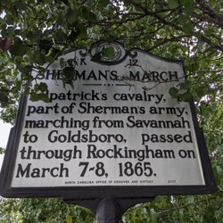
Sherman's March Historical Marker
1 review
Richmond County Judicial Center
1 review
Boggan-Hammond House
1 review
John Coltrane Historical Marker
1 review
Coulter Memorial Academy Site
1 review
Cameron Morrison School Historical Marker
1 review
Town of Wingate
1 review