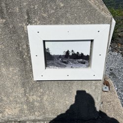
River Park Photos


You might also consider
More like River Park
Recommended Reviews - River Park
Start your review...

1 month ago
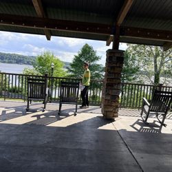
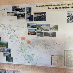
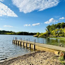
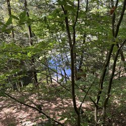
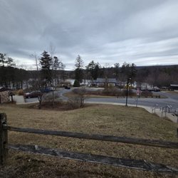
We went during the day, in beautiful weather and it was so peaceful. There are benches all along the water and rocking chairs outside of the information center to view the Susquehanna River. The staff at the information center is very friendly and help you decide where you want to walk on the River Trail if you decide to do that. If you start your walk from there, you walk across the railroad tracks and head towards Marietta on the sidewalk for a while until you are closer to the river. She suggested we drive 5 minutes to the next place to park and showed me on a map. They do have bathrooms at the information center. They also have a company that rents kayaks. This is where the boat launch is and trucks with boat trailers have to use the entrance to the water on the right side of the building and park there. On holidays and weekends I'm sure it's very busy so I would park at the lot across the street or at another entrance point. The trail is paved and everyone was friendly. There is a place to eat right across the street from the info center. You can walk or bike the River Trail or just go and sit and have a nice time. read more


5 years ago
A really nice small park and a perfect scenic stop if you're at the Turkey Hill ice cream experience. read more


8 years ago
More info about River Park
41 Walnut St
Columbia, PA 17512
Directions
(717) 684-2467
Call Now
Hours
Outdoor Amenities


River Park - parks - Updated July 2026
Best of Columbia
People found River Park by searching for…
Fishing in Columbia, Pennsylvania
Things to Do in Columbia, Pennsylvania
Fishing Spots in Columbia, Pennsylvania
River Swimming in Columbia, Pennsylvania
Dog Swimming in Columbia, Pennsylvania
Places to Take Pictures in Columbia, Pennsylvania
Walking Trails in Columbia, Pennsylvania
Splash Pad in Columbia, Pennsylvania
Running Tracks Open to the Public in Columbia, Pennsylvania
Hiking Trails With Waterfalls in Columbia, Pennsylvania
Scenic Restaurants in Columbia, Pennsylvania
Swimming Holes in Columbia, Pennsylvania
Photo Spots in Columbia, Pennsylvania
Picnic Areas in Columbia, Pennsylvania
Scenic View in Columbia, Pennsylvania
Views in Columbia, Pennsylvania
View Points in Columbia, Pennsylvania
Night View in Columbia, Pennsylvania
Scenic Drive in Columbia, Pennsylvania
Beautiful Views in Columbia, Pennsylvania
Parks for Kids in Columbia, Pennsylvania
Attractions in Columbia, Pennsylvania
Trending Searches in Columbia, PA
Black Owned Nail Salons near River Park
Dog Friendly Beaches near River Park
Jet Ski Rental near River Park
Kids Activities Outdoor near River Park
Places To Walk Around near River Park
River Swimming near River Park
Scenic Overlook near River Park
Strawberry Picking near River Park
Swimming Holes near River Park
Browse Articles
Browse Nearby
Browse Brands
Related Searches in Columbia, PA
Best Off Leash Dog Parks in Columbia, Pennsylvania
Best Parks for Parties and Events in Columbia, Pennsylvania
Best Water Parks for Kids in Columbia, Pennsylvania
Check Out Great Playgrounds in Columbia, Pennsylvania
Discover Baseball Fields Around Columbia, Pennsylvania
Discover Beautiful Garden Spots in Columbia, Pennsylvania
Discover Fun Activities to Do in Columbia, Pennsylvania
Discover Fun Toddler Parks in Columbia, Pennsylvania for Your Little One
Discover Lakes & Ponds to Explore in Columbia, Pennsylvania
Discover Popular Bike Trails in Columbia, Pennsylvania
Discover Soccer Fields in Columbia, Pennsylvania Near You
Discover Top Nature Parks to Visit in Columbia, Pennsylvania
Discover Top State Parks to Visit in Columbia, Pennsylvania
Discover the Best Beaches in Columbia, Pennsylvania
Enjoy Hiking Adventures in Columbia, Pennsylvania
Enjoy Scenic Places to Walk in Columbia, Pennsylvania
Enjoy the Best Picnic Spots and Ideas in Columbia, Pennsylvania
Enjoy the Best Walking Trails in Columbia, Pennsylvania
Explore Family-Friendly Zoos and Wildlife in Columbia, Pennsylvania
Explore Free Picnic Areas Around Columbia, Pennsylvania
Explore Fun Activities to Do in Columbia, Pennsylvania
Explore Parks With Pull Up Bars in Columbia, Pennsylvania
Explore Picnic Parks Near Columbia, Pennsylvania
Explore Popular Campgrounds Near Columbia, Pennsylvania
Explore Popular Picnic Areas Around Columbia, Pennsylvania
Explore Popular RV Parks Around Columbia, Pennsylvania
Explore Scenic Lakes to Visit in Columbia, Pennsylvania
Explore Top Dog Parks in Columbia, Pennsylvania Near You
Explore Top Trampoline Parks in Columbia, Pennsylvania
Explore Top Water Parks in Columbia, Pennsylvania Today
Explore the Best Swimming Holes Around Columbia, Pennsylvania
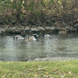
Find Great Places to Feed Ducks in Columbia, Pennsylvania
Find Top Dog Friendly Parks to Visit in Columbia, Pennsylvania
Find Top Skate Parks in Columbia, Pennsylvania for All Skill Levels
Find a Park With BBQ Pits in Columbia, Pennsylvania
Find the Best Parks BBQ Grills in Columbia, Pennsylvania
Find the Best Parks for Picnics in Columbia, Pennsylvania
Find the Best Playgrounds to Visit in Columbia, Pennsylvania
Have Fun at a Splash Pad in Columbia, Pennsylvania
Locate Tennis Courts Around Columbia, Pennsylvania
Picnic Areas With BBQ Pits Available in Columbia, Pennsylvania
Popular Picnic Spots to Visit in Columbia, Pennsylvania
Safe and Fun Parks for Kids in Columbia, Pennsylvania
Top Amusement Parks to Visit in Columbia, Pennsylvania
Top Hiking Trails to Explore in Columbia, Pennsylvania
Top Playgrounds for Kids to Enjoy in Columbia, Pennsylvania
Top Running Trails to Explore in Columbia, Pennsylvania
Top Swimming Lakes to Enjoy in Columbia, Pennsylvania