Cancel

    Open app

    Search

    Rickreall Creek Trail System

    5.0 (1 review)

    Rickreall Creek Trail System Photos

    Recommended Reviews - Rickreall Creek Trail System

    Your trust is our priority, so businesses can't pay to alter or remove their reviews. Learn more about reviews.
    Yelp app icon
    Browse more easily on the app
    Review Feed Illustration

    9 years ago

    Helpful 4
    Thanks 0
    Love this 1
    Oh no 0

    Verify this business for free

    People searched for Hiking 431 times last month within 15 miles of this business.

    Verify this business

    Cascade Head Trail

    Cascade Head Trail

    4.9(10 reviews)
    32.4 mi

    Great trail...loads to see and a real workout in the process…read more We arrived at the trailhead at 8am to be the first in the lot on a Saturday. By the time we returned the lot was full. There's a decent amount of parking...spots for cars, RVs, and trucks with boat trailers. The pre-trail wanders in and out of the trees and road for a bit, but they have great signage to lead you to the actual head. The trail is great, as you get a smidge of everything you could ask for along the way...some shaded forest, wildlife, wildflowers, stunning coastal views, and a pretty butt-kicking workout to the top viewpoint. Keep in mind, we aren't young, and neither are our hips and knees. There are a good number of high clearance steps to climb that weren't the easiest for a gal with short legs and bad hips. Not to mention that the trail is pretty steep as you zig-zag your way up the non-shaded knoll to the second viewpoint at the top of the lower trail (where it meets the upper). The trail is narrow most of the way, especially on that hillside as you push your way through the tall grasses and flowers. You definitely need to watch your step constantly going up and down, as there are hidden steps, rocks, and uneven surfaces beneath the grasses. We almost ended our trip at the lower viewpoint, but after a bit of contemplation decided to push through and up the hillside to the top. I'm super glad we made the choice, but we definitely felt it! So much to see along the way. We got to watch the elk herd as it grazed the knoll at the first opening, so beautiful. Halfway down the hill from the top a fast moving fog bank came off the coast right at us, engulfing us and removing everything from sight for a minute, while providing us with much appreciated and FABulous cold air... a very cool experience for sure. I highly recommend this trail. Go early if you go on the weekend. And if you're now young ONLY at heart, be prepared for a decent workout if you plan to go to the top...but do it, it's worth it. :)

    Wow, All I can say about this hike is WOW. One of the best views not only in Oregon but anywhere on…read morethe planet truly! On the day we went you could see everything you ever wanted to on a hike. The trek up was filled with streams and plants and at the very top a nice clear view of the beaches shorelines which seemed to have stretched on forever. We cant to come back to Oregon simply for this hike alone! Made our trip to the coastline by far the best we have ever gone too! I would highly recommend this hike to any avid hikers not because the difficulty but because the VIEW.

    Photos
    Cascade Head Trail - Cascade Head, the elk herd grazing :)

    Cascade Head, the elk herd grazing :)

    Cascade Head Trail - Cascade Head, continuing to the upper viewpoint.

    Cascade Head, continuing to the upper viewpoint.

    Cascade Head Trail - Cascade Head, Lower Nature Conservancy Trail

    See all

    Cascade Head, Lower Nature Conservancy Trail

    Marys Peak - Artesian spring

    Marys Peak

    4.9(7 reviews)
    31.2 mi

    Mary's Peak, highest of the Oregon coastal range, was a terrific day trip for our group, Eugene…read moreBurnbootcamp. Our 10:30 meet was in flux for a few days at the gym. Without confirmation, I proceeded and without incident arrived solo at Conner's Trailhead. At this point, I attempted calling the lead, who started their ascent along the summit trail. Still no contact, which usually indicated that I had not gone far enough. The lure of an artesian spring led to a brief stop and subsequent text- "Hey guys, where are you? Was it a scrub?" The sound of crunching gravel beneath my tires on the shoulder calmed my nerves a bit. That, and the fascination of an artesian well flowing off a mountainside. Two stops before the parking lot above, I encountered a small group of campers. At the Campsite, the chemical toilet was a welcome amenity. I usually find the camp signs to be interesting reading, and probably spotted the dogs on leashes or notification right away. Last stop before the top and still no word. The parking lot above is open with minimal vehicle activity. Trails are well marked and spring abounds. I set off toward the There is a group of 10-12 hikers flopped on their day packs sipping water, nibbling munchies, regarding the city beneath fog. It's also the rooster crew looking for photo ops taking a break. Several call out to me, "Look who it is." I'm splurging now on red and green Holiday Reindeer gummies and taking sips from the Camelbak. Although my trip was much shorter, uncertainty multiplied the effects of altitude. It's good to see these faces becoming more familiar in this outdoor light. I recommend familiarity with the Internet trail maps in preparation for the Mary's Peak trip. I like to have face to face contact and phone checks with others, a pancho, and small flashlight. Water, and something to chew on is a good idea. Check with the park website for rules regarding your pets. Be safe, have fun!

    Just went on this hike last weekend with my fiancé and our two eight year old boys, we had a great…read moretime! The views are pretty stunning and the hike was moderate, easy trails to follow, different terrain made it fun, we even saw snow at one edge which the kids got to make snow balls with! Wasn't too busy on a Saturday afternoon either, highly recommend this adventure.!

    Photos
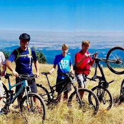
    Marys Peak - Our MTB crew!! Pedaled 7 miles to Mary's Peak from the north side fire road.

    Our MTB crew!! Pedaled 7 miles to Mary's Peak from the north side fire road.

    Marys Peak - Hike up to the peak

    Hike up to the peak

    Marys Peak

    See all

    Abiqua Falls Trailhead - The ropes section of the hike wasn't as daunting as initially feared.

    Abiqua Falls Trailhead

    4.4(10 reviews)
    35.9 mi

    Abiqua Falls! I just visited this beautiful 92-foot waterfall sort of in the middle of nowhere in…read moreOregon but located about 50 miles south of Portland. I have a lot to relay about the experience. This review could take the maximum 5000 words, lol, but I'll try my best to keep things as concise as possible... There are many questions about what to expect from Abiqua Falls. Even myself, I had concerns and doubts. But...I survived and it's an easy adventure to a very secluded waterfall. I'll try and answer the following questions... - Can you drive to the trailhead? From my POV, it's a VERY ROUGH ROAD down to the bottom. There's one specific section (and you'll recognize it immediately) where the road is practically cracked in half with divots and potholes. I actually witnessed a Ford Explorer trying to drive over it on the way back up and it was a big struggle for them! They eventually got past it, but I thought they were stuck. You absolutely need a high clearance 4x4 vehicle to make it down to the base to access the trailhead to Abiqua Falls. For me...I have a Suburu and I parked 2 miles away at the Abiqua Falls "Parking Lot" (according to Google) and then walked 2 miles down to the bottom and 2 miles back up. There was no way I was risking a flat tire, especially with not knowing how to change a tire and there barely being cell phone reception in the area. Btw...just to arrive at the Abiqua Falls parking lot, you must first drive 1.5 miles on a dirt road. For me, dirt and gravel roads are like nails on a chalkboard. I cringe driving over them. - Where is the trailhead located? This is a good question because there's no specific sign for Abiqua Falls, but it's easy to discover. Here's how...the road down to the bottom only goes so far. Eventually, you'll confront a white fence where you can leave your car (if you drove). But...there's a clear opening to the forest on the left-hand side of the road as you're going down. People say it's hard to find, but truly...you can't miss it. If you're any sort of outdoors enthusiast, it's simple. The hike is 7/10ths of a mile out and back. That's it! Again...there's barely any hiking involved, especially if you drive down to the base. - What is the ropes section like on the trail? I must be transparent. I read other people's AllTrails and Google reviews, and this can be deceiving. Let me explain... There were many reviews saying how the ropes section is intense and you're practically repelling down the cliff side. WRONG! WRONG! WRONG! It's an easy pathway. The ropes are no big deal. I have a serious fear of heights, and I casually made my down to the creek. Using the ropes was necessary for the most part, but it wasn't scary. It didn't strain my hands. IT IS NOT STRESSFUL! I'd rate the trail as easy - moderate. Do not fear the incline/decline slope. There's nothing of that sort. It is 100% safe to get up and down the trail. Once down at the bottom of the creek, hang on the left hand side. You'll notice the trail continuing around the bend that leads straight to Abiqua Falls. It's easy. I had no problems at any point in time. I've been on much, much rougher trails during my explorations. I visited on a random Thursday morning at the end of August and pretty much had the falls to myself. There were a few people that came along towards the middle of the day. I believe if you're coming to Abiqua Falls, you must bring a bathing suit and towel. I think it's a right of passage. The waterfall is scenic and the setting is charming, but other than admiring the views and maybe having a picnic, you must take the plunge in the pool of water that Abiqua Falls splashes down into. - Was the water cold? Absolutely! Lol, I was dreading the cold water but made the premeditated decision that I was swimming to have a fun memory. It wasn't even hot outside as well, but I forced myself in and I'm glad I just did it. Obviously, your body adjusts to the cold and it's not too extreme. Overall, the ambiance at Abiqua Falls was liberating. The canyon walls sort of engulf you from high above. You're standing at this dramatic waterfall and when the sun reaches above the tree line, you can notice some slight coloring in the waters which can make for a magical moment. In all, maybe you need a few hours to hang out at the falls before returning to the ropes section and heading back up to the trailhead and road. Again, the hike back up to the top is barely strenuous. It's a slight workout. Most folks can handle it. Lastly, if you're someone who left their car all the way at the top of the road (like I did), it is possible that you may get offered a lift from those hikers who took a chance driving their cars down to the base. If so, hop in, lol. It'll save time not having to trek back uphill. In the end, I enjoyed getting to witness Abiqua Falls. The journey to arrive here was not as daunting as I initially anticipated. And again, from my POV, be kind to your car tires. Don't risk the drive.

    Extremely steep. Rope system down to the bottom. I ended up fracturing my spine in 2 places due to…read morea fall. But if you're able to make it then go. Physical fitness is a MUST But a stunning falls to see

    Photos
    Abiqua Falls Trailhead - The trailhead to Abiqua Falls. It's located on the left hand side of the road.

    The trailhead to Abiqua Falls. It's located on the left hand side of the road.

    Abiqua Falls Trailhead - This is Abiqua Falls, a fantastic under the radar  Oregon waterfall.

    This is Abiqua Falls, a fantastic under the radar Oregon waterfall.

    Abiqua Falls Trailhead - Had Abiqua Falls Trail pathway saved on my phone, just in case I got lost.

    See all

    Had Abiqua Falls Trail pathway saved on my phone, just in case I got lost.

    Progress Lake

    Progress Lake

    5.0(2 reviews)
    42.0 mi

    Im not sure how successful folks are with catching fish in this large pond, but sitting by the dock…read moreis very peaceful. The lake is centered around the shopping mall so there are a few restaurant that overlook the lake. There are also ducks that live there.

    Came here today with fishing friend who did some actual fishing. Nothing was caught (fish 1 -…read morehumans 0), but it was really OK, and I thoroughly enjoyed sitting in my camping chair and watching the fish jump in the air and the world passing by. A few other people were down on the dock casting for fish, others sat on the various rock formations sort of zoning out, and it was a real pleasure to see the children and parents sharing something they really loved. If the youngsters aren't interested in the fishing, they can come down and feed the ducks - such fun. The water is so clear you can see down to rocks and plants on the bottom and also nearest the dock flashes of the goldfish as they glide along (these goldfish eventually grow into some very large carp). There are evidently some sturgeon as well along with the rainbow trout, and also lots of ducks and other water birds (a few still with babies). Oh yes, lots of dragonflies - flashes of black and fiery orange red - add to the charm. People who fish welcome you right into their society and talk readily about their fishing experiences and how the big one got away and even why. This is a terrific family experience and for those who want to come out alone. The best time is to come early, before 7, and especially after the lake has been re-stocked, if you want to catch some fish. But like I said, it's a wonderful experience whether fish are caught or not. Give it a try. And remember if you don't catch any fish, you can hike back up to the shopping center above and get some breakfast. Not a bad day at all, in fact a damn fine one if you ask me.

    Photos
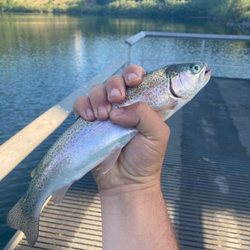
    Progress Lake - Love fishing for trout

    Love fishing for trout

    Progress Lake - Quack quack

    Quack quack

    Progress Lake

    See all

    Alsea Falls Recreation Site - Alsea falls

    Alsea Falls Recreation Site

    4.0(1 review)
    42.4 mi

    I'll be up front. I love Oregon. I love how beautiful it is here. I love the slower pace of life. I…read morelove the food. I love that people here have manners. Actual manners! Sh*t, I haven't experienced anything like this since living in New England (shoutout to NH, VT, and ME). But I digress. Dealing with folks takes a toll on me so I knew I wanted to grab a couple close friends and find a serene spot in a forest somewhere to recharge my batteries. Oregon delivered as usual. Alsea Falls Recreation Site (AFRS) is a picturesque area located 30 minutes southwest of Corvallis and boasts gorgeous forests of red cedars, maples, and Douglas firs as well as two waterfalls. I thought hiking trails here were pleasant. They offer plenty of shade and aren't very strenuous. Alsea Falls is located rather close to the day use parking lot, but there is a 1.4 mile trail leading to Green Peak Falls if you walk across the wooden bridge. The trail is poorly marked so you may lose it when you end up at McBee Park campground. Stick to the right and you will find two trails. Take the right official trail with the trail post. The left trail is shorter but there are stinging nettles along the way. Green Peak is the larger of the two falls and it is possible to climb to the top via the adjacent trail (right side), but it is steep so be careful. O T H E R I N F O -Day use parking is $3. Fill out an envelope. Drop off the envelope with payment in the receptacle across from the outhouse. Keep the stub in your vehicle. -Amenities within the campground include drinking water and vault toilets. Several campsites can accommodate large RVs or trailers; up to 32 feet long. -Dogs are allowed on a leash so bring the family pup along! -Salmon and steelhead fishing during the winter months. -The park is clean. Keep it that way and pack your trash until you find a rubbish bin. -Pack a camera. Take plenty of photos. Collect memories instead of things.
    Photos
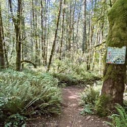
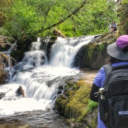
    Alsea Falls Recreation Site - On the trail to Green Peak Falls

    On the trail to Green Peak Falls

    Alsea Falls Recreation Site - Loving the PNW vibes. Found a waterfall and decided to just chill out.

    Loving the PNW vibes. Found a waterfall and decided to just chill out.

    Alsea Falls Recreation Site - Alsea Falls

    See all

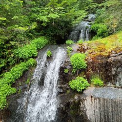
    Alsea Falls

    Rickreall Creek Trail System - hiking - Updated May 2026

    Loading...
    Loading...
    Loading...