Cancel

    Open app

    Search

    Rawah Wilderness

    5.0 (1 review)

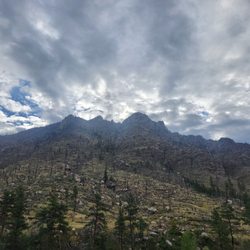
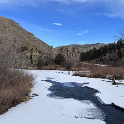
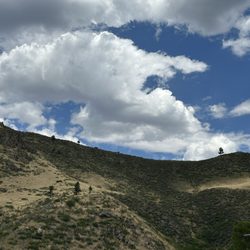
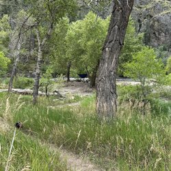
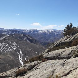
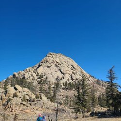
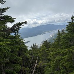
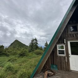
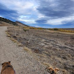
    Rawah Wilderness Photos

    Recommended Reviews - Rawah Wilderness

    Your trust is our priority, so businesses can't pay to alter or remove their reviews. Learn more about reviews.
    Yelp app icon
    Browse more easily on the app
    Review Feed Illustration

    2 years ago

    Helpful 3
    Thanks 1
    Love this 0
    Oh no 0

    Verify this business for free

    People searched for Hiking 292 times last month within 15 miles of this business.

    Verify this business

    Lory State Park - Nice display in the Visitors Center

    Lory State Park

    4.1(12 reviews)
    4.5 km

    We visited the accessible Homestead trail at Lory state park and it was lovely! There are a couple…read moreof accessible parking spots with access lanes right in front, and an accessible outhouse near the parking lot. The trail is wide enough for a wheelchair and is packed gravel/pea sized pebbles. My travel power chair did great on it, a manual chair might have trouble getting traction. It's about a half mile loop, there are informational signs throughout and benches scattered along the way if you need a place to sit. There are audio description devices available at the visitor center. There are also grills and picnic areas that are available when there is not a fire ban. Beautiful views!

    I visited Lory State Park for the first time today. Daily admission fee is $10.00…read more If you have the annual parks pass from registration renewal, there is no need to get a paper pass or placard from the Visitors Center to put in your car or hang on the rear view mirror. Your car license plates are sufficient. Park Rangers will check your plates to ensure you have the annual pass. The gentleman (volunteer) at the Visitors Center shared this information with me. I loved that he had a good sense of humor and was personable. We shared some good laughs together. I recommend going inside the Visitors Center to check out their wildlife display and to get helpful information for your visit to the park. There is also a small gift shop area to purchase books, maps and souvenirs. Staff will give you a free map of the park. There is also public restrooms at the Visitors Center. There is also a nice telescope inside the Visitors Center and a nice viewing deck with historical signage. I always enjoy reading this information for its historical value. I always learn something new. The roads in the park are all dirt so plan ahead for washing your car later. There are various parking lots to park your car before wandering off on trails. There are a lot of lovely views around. Have your camera or phone ready to take those landscape or perhaps wildlife photos. I didn't see any wildlife in the park today. I would've hiked various trails but I've been recovering from some injuries. Next time! I would love to return here. I very much enjoyed my visit to Lory Park. If you haven't been here, visit before the next snowfall! The weather was nice today so I felt fortunate. So glad I stopped here.

    Photos
    Lory State Park
    Lory State Park
    Lory State Park

    See all

    Hewlett Gulch Trail

    Hewlett Gulch Trail

    4.7(3 reviews)
    14.7 km

    Hewlett gulch is a 8.2 mile heavily trafficked trail near bellvue. It features a river and is…read morerated as moderate. Hewlett gulch is up the poudre canyon, a little further than grey rock. The parking lot is not overly big. This trail allows for off leash dogs. There is a bathroom at the trail head. There is not however any trash cans or dog poop bags. If you are coming to this trail with dogs please be sure to bring your own poop bags! Also be sure to pack out what you pack in, this includes your dog poop bags! Just pop them in your car on your way out and you could drop them at the gas station at the bottom of the canyon if you dont want to haul them all the way home. The first 2 miles are relatively flat and have multiple stream crossings. There are narrow bridges to cross on though. The first 2 miles are the prettiest in my opinion with all the water. once you get to the fork if you go left you will get the hardest over with first. The loop has no trees and no water, so on a hot day you will want to make sure that you get there before the heat. This trail does get busy on the weekends so would have a potential back up plan just in case there is no parking in the lot here.

    During this time of worry and fear, the best thing we can do (besides order takeout and delivery…read morefrom our favorite restaurants) is get outside and just breathe! It was a somber, foggy day in Fort Collins and the mountains were calling. As soon as we parked at the trailhead, the fog cleared and the sun came out. This trail has quickly become one of my favorites - a nice 8.2 mile out and back, with a large loop halfway through to liven things up. The first 3 miles are full of wildly changing landscapes. You begin walking through a grassy meadow, passing the remains of the homes the Huleatt family built in the 1920s, and have lots of stream crossings. When the waters are high, you just need to accept that it's likely you'll end up with a soggy shoe here and there. The incline is gentle and steady up until the start of the loop. I recommend going left at the fork to get the hard stuff over with faster - you gain a lot of altitude quite quickly, and it makes for a much easier-on-your-knees and relaxing slope around once you crest the top of the hike. After what feels like a bit of rock scrambling, you're rewarded with a view of the canyon that leads up to Red Feather Lakes out west, and a few magnificent homes that seem to pop up out of nowhere. Don't forget to enjoy your summit beer! The decline back to the trailhead is a complete 180 from the climb up, weaving through steep canyons with plenty of shade and plenty of spots for wild animals to hide in. I always recommend carrying bear spray and keeping an eye on your surroundings here! We came across of a pack of bighorn sheep on the way back to the car and paused to watch them traverse the sheer cliffs. The flowers during spring are some of the most beautiful I've seen, making certain spots appear as if they were out of a fairytale. This is NOT an easy hike, but that's what makes it all the more fun!

    Photos
    Hewlett Gulch Trail
    Hewlett Gulch Trail
    Hewlett Gulch Trail

    See all

    Deer Mountain Trail

    Deer Mountain Trail

    5.0(4 reviews)
    45.8 km

    I don't know what it is about Southeast (Alaska), but their trail maintenance is impeccable!…read more My partner took me to Ketch for the weekend to celebrate my 40th, so we only had time for one hike, and we chose this one. The trail is steep but very well-graded, with lots of switchbacks. The first, maybe 1.75 miles are in a lush temperate rainforest: big trees, dripping rocks, creeks flowing in/out/on/around the trail. In late March, we hit snow at about 2,100 ft. If you do this trail before June, you will have to navigate snow. Depending on conditions, you could need snowshoes/skis, microspikes, or both. We only had microspikes, but definitely needed snowshoes/skis. The final quarter mile to the summit was grueling snow-wallowing through knee-to-chest deep snow. There were lots of sketch cornices near the summit area. If you don't have experience with snow travel, I'd recommend NOT going to the true summit if you see conditions like this. (the two of us do quite a bit of mountaineering, even in the winter so....while it was unpleasant, we knew how to navigate it relatively safely) Views from the summit were amazing...for a few seconds, then the clouds rolled in. Such is life hiking in a rainforest! It took us about 4 hours to reach the summit. This was largely because of the snow though. It took us only 1 hr to get from the summit to the brewery, which is the place you need to go to treat yourself post-summit!

    Sweet fun trail hike it run it , great views up top . Tons of options of going furtherread more

    Photos
    Deer Mountain Trail
    Deer Mountain Trail
    Deer Mountain Trail

    See all

    Eagle's Nest Open Space

    Eagle's Nest Open Space

    4.7(3 reviews)
    17.4 km

    This trail is found off the road that would take you up to red feather lakes. Just past the Forks…read moregas station on the left hand side. After you turn left you will drive down a winding dirt road for a bit to get there. Thankfully the times i have visited it has not been overly busy. Which is nice. You dont find that on a lot of the trails in northern colorado. Everything around here always seems to have a lot of people, dogs, mountain bikes. sometimes you just want some solitude. Dogs and horses are allowed here. Bikes are not. There are bathrooms and trash cans at the parking lot and dog poop bags at teh trail head. For half the year, this trail is 5.3 miles long. It makes a figure 8. For the other half of the year, they close about half the trail for nesting eagles so the trail will only be around 2.5 miles long. So be sure to check the season if you are wanting a long hike. Of course any time of year, nothing says you can not just do the first loop of 2.5 miles and call it a day. There is 1 tree along this entire trail. It is very open. With gorgeous views. But this is not a trail you want to do in 100 degree weather. As with any trail it is a good idea to bring water with you. Even more so if you have dogs. This trail is home to rattle snakes so be sure to be snake aware if you go during snake season. I would personally call this trail moderate skill level. I believe i have clocked around 900 feet of elevation gain when i have done this one the last couple of times. At one point you do cross a river. You actually go over it on a bridge, but if your dogs need to get down there to cool off that is a good place to do it. it is right before you start the 2nd loop. On the 2nd loop depending on the time of year you may find yourself around a lot of cows who are out grazing. This is a lovely local hike in our area. If you have not checked it out it is worth trying at least once.

    This is one of those reviews I am torn about...I love to share travel tips but I also love the…read moresolitude this space provides and don't want it to get too popular! But it really is too beautiful not to share. I would disagree with the previous reviewer about its difficulty. I should disclose, I have only ever hiked the loop but would rate it as moderate if you are a fairly active person. If you start down the right side, you will be hiking on a cow path for half the distance. However, there is zero shade on that side. In the heat of the summer, you should remember to bring plenty of water and perhaps avoid midday. The scenery here is just gorgeous though and you are unlikely to encounter crowds like at Grey Rock or Horsetooth. On a weekday, you may have the place all to yourself! Dogs and horses are allowed on this trail but mountain bikes are not. Parking is free and there are vault toilets at the trailhead. Enjoy!!

    Photos
    Eagle's Nest Open Space
    Eagle's Nest Open Space
    Eagle's Nest Open Space

    See all

    Rawah Wilderness - hiking - Updated July 2026

    Loading...
    Loading...
    Loading...