Quinault Big Cedar Photos


More like Quinault Big Cedar
Recommended Reviews - Quinault Big Cedar
Start your review...

Reviews With Photos

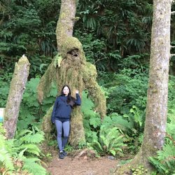
Good lord this tree is huge. My husband and I named it Steve the Cedar. It's friend Bruce the Spruce is on the other side of the lake and I'm sure they chat often. It's a bit of a hike to get back to this tree because not only is it all uphill but the stairs leading to it are made for giants. Be sure to go all the way around it because you can actually stand inside it! Gosh nature rocks!

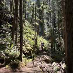
Not to be confused with the largest spruce tree. If you're on your way up to La Push you should see this sign for the cedar probably about 10-15 minutes outside Amanda Park and kind of on the perimeter of the Olympic Nat'l Forest on North Shore Road. The road is pretty primitive and has huge divots and potholes so proceed with caution. The trail is also pretty muddy even with the slightest rain so again, proceed with caution. With that said, this cedar is actually pretty huge. A large majority of it has collapsed and spilled it's guts onto the forest floor but it's still a neat sight to see. You can walk on it or climb through the holes and just crank your neck up at such a gargantuan natural phenomena. Even with the spilled guts, there is still a lot of tree left standing. It's free to check out and not far off the roadway so it's a quick stop. read more


13 years ago
The world's biggest cedar is a pretty fantastic tree. The tiny sign next to the road doesn't do it justice. Park next to the road and prepare for a short, yet epic hike. The hike up to the tree builds just the right amount of anticipation as it's just like climbing up a treehouse. Navigating steep stairs (as high as I could lift my leg) and scampering over tree roots yields a great payoff when you reach the top. Be sure to walk all the way around it as you can actually go inside it. I'm sure there are studio apartments smaller than the inside of this tree. Wear boots as it can get mucky back there! Take some pics and clamber back down. Congrats! Now you've just seen my new favorite tree! read more
7 years ago
16 years ago
Good lord this tree is huge. My husband and I named it Steve the Cedar. It's friend Bruce the Spruce is on the other side of the lake and I'm sure they chat often. It's a bit of a hike to get back to this tree because not only is it all uphill but the stairs leading to it are made for giants. Be sure to go all the way around it because you can actually stand inside it! Gosh nature rocks! read more

10 years ago
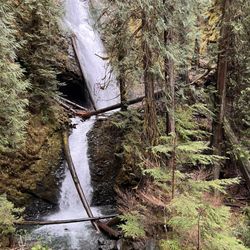
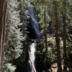
Unfortunately this huge sentinel of the North Shore succumbed to the forces of nature/gravity, around July 8-10, 2016. The signs have been removed, but if you know where it is it's worth the hike. There's lots of cool stuff to see anyway, if you're observant. There is a large tree across the trail that's not too hard to navigate, but turning the corner, it also fell along the stairs making it a tight squeeze. read more

11 years ago
More info about Quinault Big Cedar
Ask the Community - Quinault Big Cedar


Quinault Big Cedar - hiking - Updated May 2026
Best of Amanda Park
People found Quinault Big Cedar by searching for…
Things to Do in Amanda Park, Washington
Hiking Trails With Waterfalls in Amanda Park, Washington
Parks in Amanda Park, Washington
Off Road Trails in Amanda Park, Washington
Waterfalls in Amanda Park, Washington
Things to Do on a Rainy Day in Amanda Park, Washington
Running Trails in Amanda Park, Washington
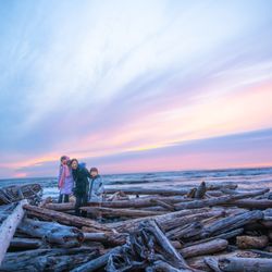
Hiking With Kids in Amanda Park, Washington
Waterfalls and Swimming Holes in Amanda Park, Washington
Swimming Lakes in Amanda Park, Washington
Easy Hiking Trails in Amanda Park, Washington
Places to Walk in Amanda Park, Washington
Dinner With a View in Amanda Park, Washington
Family Fun in Amanda Park, Washington
Walking Trails in Amanda Park, Washington
Lunch With a View in Amanda Park, Washington
To Do in Amanda Park, Washington
Parks With Lakes in Amanda Park, Washington
Bridge in Amanda Park, Washington
Parks for Kids in Amanda Park, Washington
Tourist Attractions in Amanda Park, Washington
Places to Take Pictures in Amanda Park, Washington
Browse Articles
Browse Nearby
BEST of Amanda Park, Washington Things to Do near Quinault Big Cedar
BEST of Amanda Park, Washington Restaurants near Quinault Big Cedar
BEST of Amanda Park, Washington Coffee near Quinault Big Cedar
BEST of Amanda Park, Washington Parks near Quinault Big Cedar
BEST of Amanda Park, Washington Beaches near Quinault Big Cedar
BEST of Amanda Park, Washington Breakfast near Quinault Big Cedar
BEST of Amanda Park, Washington Hotels near Quinault Big Cedar
BEST of Amanda Park, Washington Lodging near Quinault Big Cedar
Browse Brands
Related Searches in Amanda Park, WA
Best Fishing Locations and Guides in Amanda Park, Washington
Best Lookout Points to Visit in Amanda Park, Washington
Best Spots for Star Gazing in Amanda Park, Washington
Discover Dog Friendly Trails to Explore in Amanda Park, Washington
Discover Popular Bike Trails in Amanda Park, Washington
Discover Popular Photo Spots in Amanda Park, Washington
Discover Top Boat Tours in Amanda Park, Washington for All Ages
Discover Top Nature Parks to Visit in Amanda Park, Washington
Discover a Hiking Trail in Amanda Park, Washington
Discover the Best Night Hike Trails in Amanda Park, Washington
Discover the Best Running Track in Amanda Park, Washington
Dog-Friendly Hikes With Dogs in Amanda Park, Washington
Enjoy Camping Adventures Around Amanda Park, Washington
Enjoy Scenic Night View Experiences in Amanda Park, Washington
Enjoy Tent Camping Spots Around Amanda Park, Washington
Enjoy the Best Picnic Spots and Ideas in Amanda Park, Washington
Enjoy the Best Walking Trails in Amanda Park, Washington
Experience Stunning Sunset Views in Amanda Park, Washington
Explore Beautiful Parks and Green Spaces in Amanda Park, Washington
Explore Easy Hikes Perfect for All in Amanda Park, Washington
Explore Popular Campgrounds Near Amanda Park, Washington
Explore Popular RV Parks Around Amanda Park, Washington
Explore Popular View Points Around Amanda Park, Washington
Explore Scenic Lakes to Visit in Amanda Park, Washington
Explore Secret Spots Worth Visiting in Amanda Park, Washington
Explore Top Dog Parks in Amanda Park, Washington Near You
Explore the Best Beach Spots in Amanda Park, Washington
Explore the Best Swimming Holes Around Amanda Park, Washington
Explore the Best Trail Options in Amanda Park, Washington
Family Friendly Hiking With Kids in Amanda Park, Washington
Find Beautiful Views in Amanda Park, Washington
Find Cozy Camping Cabins in Amanda Park, Washington
Find Fun Kids Activities Outdoor in Amanda Park, Washington
Find Parks and Recreation Activities in Amanda Park, Washington
Find the Best Parks for Picnics in Amanda Park, Washington
Hiking Trails With Waterfalls in Amanda Park, Washington
Must-See Tourist Attractions Around Amanda Park, Washington
Off Leash Dog Hiking Trails in Amanda Park, Washington
Perfect Spots to Watch Sunset in Amanda Park, Washington
Picnic Areas With BBQ Pits Available in Amanda Park, Washington
Plan Nature Center Visits in Amanda Park, Washington
Plan a Scenic Drive Route Near Amanda Park, Washington
Popular Fishing Spots to Explore in Amanda Park, Washington
Popular Picnic Spots to Visit in Amanda Park, Washington
Popular Places to Take Pictures in Amanda Park, Washington
Popular Things to Do in Amanda Park, Washington
Safe River Swimming Areas in Amanda Park, Washington
Safe and Fun Parks for Kids in Amanda Park, Washington