Perry State Park Photos


More like Perry State Park
Recommended Reviews - Perry State Park
Start your review...

Reviews With Photos

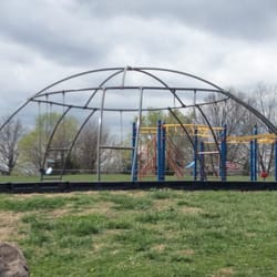
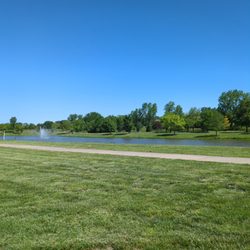
We have been traveling for thousands of miles and have stayed at many parks . We ran across this one and it was quite the hidden gem! Off our path by about 20 min but well worth it. We stayed at the rock creek camp. Big sites , beautiful views of the lake. We dry camped so we had waterfront, however even the electric hook ups had water views. Nice grass lots, clean, good priced, and a cute little playground for the kids . Would definitely stay again.

First weekend out camping and kayaking. Great camping site and beautiful lake. Restroom facilities did their job but could be a little cleaner. Hot weekend but good breezes. Water was a tad choppy but enjoyed the kayaking. read more


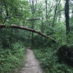
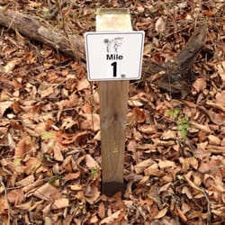
Perry state park is about 20 miles northeast of Topeka Kansas and is one of the better Kansas state parks that I have been to. A beach, campgrounds, and a boating/ fishing area is available to the public as well as an extensive hiking area. I partook in the hiking area, and it was well worth it. This is a real hiking area, no paved trails or off looks, just rocky crags, and a challenge. There are about eight trails that weave extensively through several different terrains including wooded areas, lake sides, prairie grass, and steep climbs. The trails were not well marked and one could easily get lost, as I said before the trails often weaved into each other and it was hard to tell which trail you were on at times. Even the provided maps were not that helpful because there was no legend to tell you how long the trails are. These trails are not really meant for the leisurely hiking/ bicycling type, and as a word of warning make sure you bring bug repellent, after the trek my partner and I found several ticks and other bugs crawling all over us. read more

This review is an overview of two of the most challenging hiking areas in Perry State Park. As someone who is an experienced outdoor hiker I was pleasantly surprised at the trails here. 29 miles in all, this was the first time I've set foot on them. The fact I have to drive about 30 minutes when there is good lake hiking much closer to my house is the reason behind never visiting here. I will visit here again soon and test the other areas and report back if something new is discovered. Old Military Trail (Section 2 East) and Section 2 West comprise 7.7 miles of the trail in a continuous path, and yesterday I hiked from the trail-head to the end and back, so 15+ miles, a very long but good day. Two things make a trail great: 1) terrain, the views, the stopping points, diversity in terrain, and most importantly, 2) trail maintenance and markings. This is undoubtedly a great trail with many unbelievably scenic views of the lake and some terrific places to stop for a break and rest up. The trails should be considered rough and challenging which in itself is not cause for concern unless you're a rookie hiker. Trail maintenance, I'm sorry to say, is sorely lacking and that's too bad because it has incredible potential. I encountered way too many large fallen trees blocking the path to provide a better rating, and it's clear they've been like this for a considerable time. Parts of the trail are more used than others and it parts it gets downright poorly maintained and difficult to follow. Trail markings on trees are generally quite thorough though, so no complaints until a further point in the hike when it all came crashing down. The most disappointing part for me is near the end of Section 2 West you come to an abrupt open field after the trail has already disappeared for about a half mile in tall native grasses. At that point, I had ambition to continue on but was forced to turn back because I couldn't find the trail connection. This Section which is noted as approaching Longview Park seems to be lost. For it to be this way I think it has not been maintained safely for in excess of a year--far too long for most wilderness trails. If you're boasting a 29 mile continuous trail and someone with my level of experience can't find the connecting trail, you have a poorly maintained resource. That said, this is Kansas, not Colorado or even Missouri. Great trail resources are far a few between. My next plan of attack will to be to hike the southern part of the trail I wished to connect with the intention of exploring why or where this part of the trail seemingly disappears. Meantime, lets hope trail maintenance gets its act in gear. It's easy to tell this trail is not used a lot and that's too bad, but if you're going to boast 29 continuous miles, please make sure the people using the resource can actually continue on as the map seemingly indicates. read more


9 years ago
We have been traveling for thousands of miles and have stayed at many parks . We ran across this one and it was quite the hidden gem! Off our path by about 20 min but well worth it. We stayed at the rock creek camp. Big sites , beautiful views of the lake. We dry camped so we had waterfront, however even the electric hook ups had water views. Nice grass lots, clean, good priced, and a cute little playground for the kids . Would definitely stay again. read more

14 years ago
9 years ago
7 years ago
We made the drive to Lake Perry in about an hour from our home in Overland Park. We started out near the information center where there is a great hill overlooking the lake. The lake is good sized and there were an array of boats enjoying it. The hill was a nice spot to take in the view while eating lunch and playing some frisbee. We next went hiking and chose the Delaware Marsh Trail because it sounded like it had the best shot of having some good scenery. The trail started out with a somewhat worn path. It made it tricky to take in the sights because I was concentrating more on where I (and my daughter after me) was stepping. We did see some great birds along the way, including some enormous hawks. The trail passes the Delaware River in two spots, but both at heights making the river out of reach. The marsh was fairly low, but we did find a spot where we could venture down and view hundreds of small frogs. Then, at about 60% through the trail the worn part of the trail just stopped. There were still markers, but we were suddenly wading through waist high grass. Or, in my daughters case, face high. Thankfully we had doused our legs with Off! beforehand, or we would have been eaten alive I am sure. My daughter did not enjoy this part of the hike at all and I can't say I love it either. To me, the scenery along the way is not worth the trip it takes to get there and back. I definitely don't recommend this hike for kids. read more

More info about Perry State Park
Ask the Community - Perry State Park


Why does Yelp recommend reviews?
Perry State Park - hiking - Updated June 2026
Best of Ozawkie
People found Perry State Park by searching for…
Campgrounds in Ozawkie, Kansas
Playgrounds in Ozawkie, Kansas
Things to Do in Ozawkie, Kansas
Secret Spots in Ozawkie, Kansas
Scenic View in Ozawkie, Kansas
Fishing Spots in Ozawkie, Kansas
Scenic Drive in Ozawkie, Kansas
Water Parks in Ozawkie, Kansas
View Points in Ozawkie, Kansas
Public Shower in Ozawkie, Kansas
Scenic Overlook in Ozawkie, Kansas
Hiking Trails in Ozawkie, Kansas
Beautiful Views in Ozawkie, Kansas
Fishing Lake in Ozawkie, Kansas
Camping Sites in Ozawkie, Kansas
Secluded Spots in Ozawkie, Kansas
Swimming Lakes in Ozawkie, Kansas
Walking Trails in Ozawkie, Kansas
River Swimming in Ozawkie, Kansas
Trending Searches in Ozawkie, KS
Boat Rental near Perry State Park
Day Trips near Perry State Park
Dog Friendly Trails near Perry State Park
Fireworks near Perry State Park
Fishing Spots near Perry State Park
Outdoor Activities near Perry State Park
Outdoor Basketball Courts near Perry State Park
Places To Swim near Perry State Park
Public Pools near Perry State Park
Public Shower near Perry State Park
Secluded Spots near Perry State Park
Soccer Store near Perry State Park
Splash Pad near Perry State Park
Swimming Holes near Perry State Park
Swimming Lakes near Perry State Park
U Pick Farms near Perry State Park
Watch Sunset near Perry State Park
Browse Articles
Browse Brands
Related Searches in Ozawkie, KS
Best Nature Trails for Hiking in Ozawkie, Kansas
Best Off Leash Dog Parks in Ozawkie, Kansas
Best Parks for Parties and Events in Ozawkie, Kansas
Best Water Parks for Kids in Ozawkie, Kansas
Best Waterfalls and Swimming Holes in Ozawkie, Kansas
Check Out Great Playgrounds in Ozawkie, Kansas
Check Out Off Road Trails in Ozawkie, Kansas
Discover Baseball Fields Around Ozawkie, Kansas
Discover Dog Friendly Trails to Explore in Ozawkie, Kansas
Discover Fun Toddler Parks in Ozawkie, Kansas for Your Little One
Discover Lakes & Ponds to Explore in Ozawkie, Kansas
Discover Popular Bike Trails in Ozawkie, Kansas
Discover Popular Photo Spots in Ozawkie, Kansas
Discover Scenic Mountain Bike Trails Near Ozawkie, Kansas
Discover Soccer Fields in Ozawkie, Kansas Near You
Discover Stunning Skyline View Spots in Ozawkie, Kansas
Discover Top Nature Parks to Visit in Ozawkie, Kansas
Discover a Hiking Trail in Ozawkie, Kansas
Discover the Best Night Hike Trails in Ozawkie, Kansas
Discover the Best Running Track in Ozawkie, Kansas
Dog-Friendly Hikes With Dogs in Ozawkie, Kansas
Enjoy the Best Night View Spots in Ozawkie, Kansas
Enjoy the Best Picnic Spots and Ideas in Ozawkie, Kansas
Enjoy the Best Walking Trails in Ozawkie, Kansas
Experience Stunning Sunset Views in Ozawkie, Kansas
Explore Beautiful Parks and Green Spaces in Ozawkie, Kansas
Explore Easy Hikes Perfect for All in Ozawkie, Kansas
Explore Free Picnic Areas Around Ozawkie, Kansas
Explore Popular Campgrounds Near Ozawkie, Kansas
Explore Popular Picnic Areas Around Ozawkie, Kansas
Explore Popular Scenic Overlook Points in Ozawkie, Kansas
Explore Popular Scenic Views Near Ozawkie, Kansas
Explore Popular View Points Around Ozawkie, Kansas
Explore Secret Spots Worth Visiting in Ozawkie, Kansas
Explore Top Gyms in Ozawkie, Kansas Now
Explore the Best Swimming Holes Around Ozawkie, Kansas
Explore the Best Trail Options in Ozawkie, Kansas
Family Friendly Hiking With Kids in Ozawkie, Kansas
Find Beautiful Views in Ozawkie, Kansas
Find Fun Kids Activities Outdoor in Ozawkie, Kansas
Find Parks and Recreation Activities in Ozawkie, Kansas
Find Picnic Tables for Outdoor Fun in Ozawkie, Kansas
Find Top Dog Friendly Parks to Visit in Ozawkie, Kansas
Find Top Dog Swimming Spots in Ozawkie, Kansas
Find Top-Rated Waterfalls in Ozawkie, Kansas Now
Find a Park With BBQ Pits in Ozawkie, Kansas
Find the Best Parks for Picnics in Ozawkie, Kansas
Find the Best Scenic View Locations in Ozawkie, Kansas