Perkiomen Trail Photos


You might also consider
More like Perkiomen Trail
Recommended Reviews - Perkiomen Trail
Start your review...

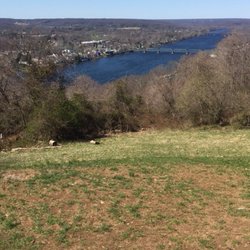
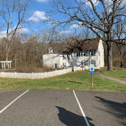
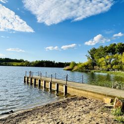
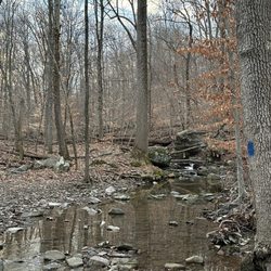
It's mostly gravel and some paved trail and rated as "easy." We started our walk at the Central Perkiomen Valley Park in Schwenksville and went for a little over three miles and turned around to the park. Most of our trail was covered by trees, but there were some open places. We observed some wild animals like deer along the way. There was a 12% grade hill (for about 1/4 mile) along the way which gave some of us a little challenge especially our climb was almost towards the end of 6.5 mile walk. We took an advantage of a bench located at the top of the hill. The Perkiomen Trail is a 19-mile-long multi-use trail along the Perkiomen Creek in Pennsylvania. It begins at the junction with the Schuylkill River Trail near the mouth of the Perkiomen and Valley Forge National Historical Park and ends in Green Lane Park. For the most of its length, the "Perky" as it is know by the locals, uses the former rail bed of the Perkiomen Line of the Reading Railroad. Some of our cohorts were terribly bothered by the swarm of cicadas along some part of our route of about 6.5 miles. It seemed it was especially challenging when we crossed over three bridges. I was trying to be kind, but it was particularly hilarious watching them dodge cicadas since some of them landed on their bodies...I had some fun at their expense. It was a very nice walk in the afternoon with some cloud cover and breeze. read more


More info about Perkiomen Trail
Perkiomen Trail
Collegeville, PA 19426
Directions
Hours
Outdoor Amenities


Perkiomen Trail - hiking - Updated May 2026
Best of Collegeville
People found Perkiomen Trail by searching for…
Parks in Collegeville, Pennsylvania
Things to Do in Collegeville, Pennsylvania
Walking Trails in Collegeville, Pennsylvania
Hiking Trails in Collegeville, Pennsylvania
Walking Groups in Collegeville, Pennsylvania
Off Road Trails in Collegeville, Pennsylvania
Scenic Views in Collegeville, Pennsylvania
Running Trails in Collegeville, Pennsylvania
Easy Hikes in Collegeville, Pennsylvania
Off Leash Dog Hikes in Collegeville, Pennsylvania
Creeks in Collegeville, Pennsylvania
Things to Do at Night in Collegeville, Pennsylvania
Fun Things to Do With Kids in Collegeville, Pennsylvania
Nature Reserves in Collegeville, Pennsylvania
Places to Take Pictures in Collegeville, Pennsylvania
Places to Walk in Collegeville, Pennsylvania
Running Routes in Collegeville, Pennsylvania
Waterfalls in Collegeville, Pennsylvania
Hiking Trails Kid Friendly in Collegeville, Pennsylvania
Trail in Collegeville, Pennsylvania
Places to Visit in Collegeville, Pennsylvania
Secluded Spots in Collegeville, Pennsylvania
Trending Searches in Collegeville, PA
Botanical Gardens near Perkiomen Trail
Bounce House Rentals near Perkiomen Trail
Campgrounds near Perkiomen Trail
Cheap Plants near Perkiomen Trail
Cherry Picking near Perkiomen Trail
Cliff Jumping near Perkiomen Trail
Dog Friendly Things To Do near Perkiomen Trail
Flower Fields near Perkiomen Trail
Flower Shop near Perkiomen Trail
Garage Sales near Perkiomen Trail
Garden Center near Perkiomen Trail
Lakes & Ponds near Perkiomen Trail
Nurseries & Gardening near Perkiomen Trail
Outdoor Activities near Perkiomen Trail
Outdoor Furniture Stores near Perkiomen Trail
Party Equipment Rentals near Perkiomen Trail
Photo Spots near Perkiomen Trail
Picnic Areas near Perkiomen Trail
Places To Take Pictures near Perkiomen Trail
Rock Quarry near Perkiomen Trail
Running Trails near Perkiomen Trail
Rv Rental near Perkiomen Trail
Spray Tanning near Perkiomen Trail
Sunrise View near Perkiomen Trail
Swimming Holes near Perkiomen Trail
Table And Chair Rentals near Perkiomen Trail
Browse Articles
Browse Nearby
BEST of Collegeville, Pennsylvania Restaurants near Perkiomen Trail
BEST of Collegeville, Pennsylvania Coffee near Perkiomen Trail
BEST of Collegeville, Pennsylvania Things to Do near Perkiomen Trail
BEST of Collegeville, Pennsylvania Parks near Perkiomen Trail
BEST of Collegeville, Pennsylvania Breakfast near Perkiomen Trail
BEST of Collegeville, Pennsylvania Playgrounds near Perkiomen Trail
BEST of Collegeville, Pennsylvania Hotels near Perkiomen Trail
Browse Brands
Related Searches in Collegeville, PA
Affordable Kayak Rental Services in Collegeville, Pennsylvania
Best Fishing Locations and Guides in Collegeville, Pennsylvania
Best Nature Trails for Hiking in Collegeville, Pennsylvania
Best Places for Horseback Riding in Collegeville, Pennsylvania
Best Places for Stunning Views in Collegeville, Pennsylvania
Check Out Off Road Trails in Collegeville, Pennsylvania
Discover Dog Friendly Trails to Explore in Collegeville, Pennsylvania
Discover Scenic Mountain Bike Trails Near Collegeville, Pennsylvania
Discover Scenic Running Paths in Collegeville, Pennsylvania
Discover Top Scenic Spots to Visit in Collegeville, Pennsylvania
Discover Top State Parks to Visit in Collegeville, Pennsylvania
Discover a Hiking Trail in Collegeville, Pennsylvania
Discover the Best Night Hike Trails in Collegeville, Pennsylvania
Effective Stairs Workout Spots in Collegeville, Pennsylvania
Enjoy Camping Adventures Around Collegeville, Pennsylvania
Enjoy Exciting Mountain Biking Adventures in Collegeville, Pennsylvania
Enjoy Kayaking Adventures in Collegeville, Pennsylvania
Enjoy the Best Walking Trails in Collegeville, Pennsylvania
Exciting Cliff Jumping Spots in Collegeville, Pennsylvania
Experience Thrilling White Water Rafting in Collegeville, Pennsylvania
Explore Beautiful Parks and Green Spaces in Collegeville, Pennsylvania
Explore Easy Hikes Perfect for All in Collegeville, Pennsylvania
Explore Popular Campgrounds Near Collegeville, Pennsylvania
Explore Scenic Lakes to Visit in Collegeville, Pennsylvania
Explore Top Dog Parks in Collegeville, Pennsylvania Near You
Explore the Best Beach Spots in Collegeville, Pennsylvania
Explore the Best Boating Spots in Collegeville, Pennsylvania
Explore the Best Swimming Holes Around Collegeville, Pennsylvania
Explore the Best Trail Options in Collegeville, Pennsylvania
Family Friendly Hiking With Kids in Collegeville, Pennsylvania
Find Beautiful Views in Collegeville, Pennsylvania
Find Popular Ziplining Spots Around Collegeville, Pennsylvania
Find the Best Parks for Picnics in Collegeville, Pennsylvania
Find the Best Playgrounds to Visit in Collegeville, Pennsylvania
Find the Best Scenic View Locations in Collegeville, Pennsylvania
Hiking Trails With Waterfalls in Collegeville, Pennsylvania
Off Leash Dog Hiking Trails in Collegeville, Pennsylvania
Plan a Scenic Drive Route Near Collegeville, Pennsylvania
Popular Fishing Spots to Explore in Collegeville, Pennsylvania
Popular Outdoor Activities to Try in Collegeville, Pennsylvania
Popular Picnic Spots to Visit in Collegeville, Pennsylvania
Popular Things to See in Collegeville, Pennsylvania
Safe River Swimming Areas in Collegeville, Pennsylvania
Safe and Fun Parks for Kids in Collegeville, Pennsylvania
Top Climbing Spots and Gyms in Collegeville, Pennsylvania
Top Paddleboarding Activities in Collegeville, Pennsylvania
Top Running Trails to Explore in Collegeville, Pennsylvania
Top Swimming Lakes to Enjoy in Collegeville, Pennsylvania
Top Things to Do With Kids in Collegeville, Pennsylvania
Walk Dog Friendly Hiking Trails in Collegeville, Pennsylvania
People who viewed Perkiomen Trail also viewed
Pennsy Trail
4 reviews
Audubon Loop Trail
1 review
Perkiomen Trail
6 reviews
Middletown Township Memorial Park
2 reviews
Upper Providence Park
1 review
Rocky Run Trail
3 reviews
Stroud Preserve - Natural Lands
7 reviews
Waterloo Mills Preserve
1 review
Darby Creek Trail
3 reviews
George Lorimer Nature Preserve
1 review