Audubon Loop Trail Photos


You might also consider
More like Audubon Loop Trail
Recommended Reviews - Audubon Loop Trail
Start your review...

4 years ago
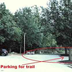
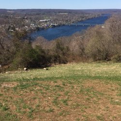
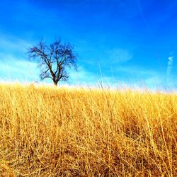
Approx 5 mile loop around the John James Audubon center and its environs. This trail is paved and permits dogs and bikes (while the center's unpaved trails permit neither). I called the Audubon center prior to visiting to make sure I knew what to expect. Two emails and a phone convo with them, as well as studying the map on their website, somehow did not prepare me for what this was. I thought the trail would loop the perimeter of the Audubon property, however it encompasses a bit more. First, be aware that it crosses 422 (overpass, not crosswalk, lol, but still). This was huge for me with a toddler on a balance bike. I was really surprised that though I mentioned my kid's young age, no one at the center thought to inform me that long stretches of this trail are the direct sidewalk of highways, or other high speed roads. Yikes! Not only was this terrifying with a child, but with dogs as well! The center actually told me "there are a bunch of kids here riding bikes on the loop trail today"--WHATTT??? I did not see one other kid riding a bike on the whole five miles, and no wonder! For my terror and the totally unrelaxing feeling of road drama and noise for the bulk of this two-hour experience, I give this trail zero stars. But I can see the value of it for older children and adults on bikes (though they still need to be pretty careful), and older kids/adults hiking or jogging. It can be exciting to walk over and under some of the highway bridges, and some of the scenery is cool, but there are definitely safer equally-thrilling trails in the area. That said, this trail connects to other well known trails, mainly the Perkiomen and Schuylkill River Trails. There is actually a lot of overlap with those trails, which made me often wonder if I was still on the loop proper, but alas, I was. All in all I give it a three because I feel bad as FTR rating it, and because I hope it attracts people away from my other favorite trails so they don't get too crowded. Free parking at various access points for this trail: Audubon Center, Lower Perkiomen Valley Park, and Pawlings Road Trailhead. All had trail maps, dog poo stations, trash cans, and plenty of parking. Lower Perkiomen and Audubon have bathrooms though you have to hunt a ways from the trail (and Audubon's closes when their visitor center does). As for birds, I saw vultures, a goose, and a lonely duck. read more


 - Hiking Near Me - Audubon, Pennsylvania")
 - Hiking Near Me - Audubon, Pennsylvania")
 - Hiking Near Me - Audubon, Pennsylvania")


More info about Audubon Loop Trail
1201 Pawlings Rd
Audubon, PA 19403
Directions
Hours
Outdoor Amenities


Audubon Loop Trail - hiking - Updated July 2026
Best of Audubon
People found Audubon Loop Trail by searching for…
Parks in Audubon, Pennsylvania
Things to Do in Audubon, Pennsylvania
Hiking Trails in Audubon, Pennsylvania
Walking Trails in Audubon, Pennsylvania
Walking Groups in Audubon, Pennsylvania
Running Trails in Audubon, Pennsylvania
Attractions in Audubon, Pennsylvania
Free Parking in Audubon, Pennsylvania
Scenic View in Audubon, Pennsylvania
Visitor Centers in Audubon, Pennsylvania
Fun Things to Do at Night in Audubon, Pennsylvania
Waterfalls in Audubon, Pennsylvania
Kids Attractions in Audubon, Pennsylvania
Trails in Audubon, Pennsylvania
Bridge in Audubon, Pennsylvania
Jogging at Night in Audubon, Pennsylvania
Swimming Holes in Audubon, Pennsylvania
Dog Friendly Trails in Audubon, Pennsylvania
Scenic Spots in Audubon, Pennsylvania
Off Leash Dog Hikes in Audubon, Pennsylvania
Sunset View in Audubon, Pennsylvania
Free Things to Do With Kids in Audubon, Pennsylvania
Trending Searches in Audubon, PA
4th Of July Fireworks near Audubon Loop Trail
Black Owned Nail Salons near Audubon Loop Trail
Boat Rental near Audubon Loop Trail
Creeks near Audubon Loop Trail
Day Trips near Audubon Loop Trail
Dog Friendly Trails near Audubon Loop Trail
Fireworks near Audubon Loop Trail
Kayak Rental near Audubon Loop Trail
Lakes & Ponds near Audubon Loop Trail
Outdoor Activities near Audubon Loop Trail
Places To Walk Around near Audubon Loop Trail
Public Pools near Audubon Loop Trail
Public Shower near Audubon Loop Trail
River Swimming near Audubon Loop Trail
Rock Quarry near Audubon Loop Trail
Running Trails near Audubon Loop Trail
Scenic Overlook near Audubon Loop Trail
Secluded Spots near Audubon Loop Trail
Soccer Store near Audubon Loop Trail
Splash Pad near Audubon Loop Trail
Strawberry Picking near Audubon Loop Trail
Swimming Holes near Audubon Loop Trail
Swimming Lakes near Audubon Loop Trail
Swimming Pools near Audubon Loop Trail
Watch Sunset near Audubon Loop Trail
Browse Articles
Browse Nearby
BEST of Audubon, Pennsylvania Things to Do near Audubon Loop Trail
BEST of Audubon, Pennsylvania Coffee near Audubon Loop Trail
BEST of Audubon, Pennsylvania Restaurants near Audubon Loop Trail
BEST of Audubon, Pennsylvania Breakfast near Audubon Loop Trail
BEST of Audubon, Pennsylvania Walking Trails near Audubon Loop Trail
BEST of Audubon, Pennsylvania Parks near Audubon Loop Trail
BEST of Audubon, Pennsylvania Campgrounds near Audubon Loop Trail
BEST of Audubon, Pennsylvania Day Trips near Audubon Loop Trail
Browse Brands
Related Searches in Audubon, PA
Best Fishing Locations and Guides in Audubon, Pennsylvania
Best Fun Things to Do in Audubon, Pennsylvania
Best Off Leash Dog Parks in Audubon, Pennsylvania
Best Places for Horseback Riding in Audubon, Pennsylvania
Best Spots for Star Gazing in Audubon, Pennsylvania
Discover Dog Friendly Trails to Explore in Audubon, Pennsylvania
Discover Popular Photo Spots in Audubon, Pennsylvania
Discover Top Boat Tours in Audubon, Pennsylvania for All Ages
Discover a Hiking Trail in Audubon, Pennsylvania
Discover the Best Night Hike Trails in Audubon, Pennsylvania
Discover the Best Running Track in Audubon, Pennsylvania
Dog-Friendly Hikes With Dogs in Audubon, Pennsylvania
Enjoy the Best Tubing Experiences in Audubon, Pennsylvania
Enjoy the Best Walking Trails in Audubon, Pennsylvania
Experience Stunning Sunset Views in Audubon, Pennsylvania
Explore Beautiful Botanical Gardens in Audubon, Pennsylvania
Explore Beautiful Parks and Green Spaces in Audubon, Pennsylvania
Explore Bike Rentals Throughout Audubon, Pennsylvania
Explore Easy Hikes Perfect for All in Audubon, Pennsylvania
Explore Free Things to Do Around Audubon, Pennsylvania
Explore Fun Activities to Do in Audubon, Pennsylvania
Explore Popular Campgrounds Near Audubon, Pennsylvania
Explore Popular RV Parks Around Audubon, Pennsylvania
Explore Scenic Lakes to Visit in Audubon, Pennsylvania
Explore Secret Spots Worth Visiting in Audubon, Pennsylvania
Explore Top Dog Parks in Audubon, Pennsylvania Near You
Explore Top Water Parks in Audubon, Pennsylvania Today
Find Beautiful Views in Audubon, Pennsylvania
Find Fun Things to Do With Kids in Audubon, Pennsylvania
Find Popular Ziplining Spots Around Audubon, Pennsylvania
Find Top Dog Swimming Spots in Audubon, Pennsylvania
Find Top-Rated Disc Golf in Audubon, Pennsylvania
Find the Best Playgrounds to Visit in Audubon, Pennsylvania
Find the Best Swimming Pools in Audubon, Pennsylvania Today
Great Places to Swim in Audubon, Pennsylvania
Hiking Trails With Waterfalls in Audubon, Pennsylvania
Must-See Tourist Attractions Around Audubon, Pennsylvania
Off Leash Dog Hiking Trails in Audubon, Pennsylvania
Perfect Spots to Watch Sunset in Audubon, Pennsylvania
Plan a Scenic Drive Route Near Audubon, Pennsylvania
Popular Fishing Spots to Explore in Audubon, Pennsylvania
Popular Kids Activities in Audubon, Pennsylvania
Popular Picnic Spots to Visit in Audubon, Pennsylvania
Popular Places to Take Pictures in Audubon, Pennsylvania
Popular Things to Do in Audubon, Pennsylvania
Safe and Fun Parks for Kids in Audubon, Pennsylvania
Top Paddleboarding Activities in Audubon, Pennsylvania
Top Playgrounds for Kids to Enjoy in Audubon, Pennsylvania