Peavine Trail Photos


You might also consider
More like Peavine Trail
Recommended Reviews - Peavine Trail
Start your review...

Reviews With Photos - Peavine Trail

We arrived here before 11 a.m. on a Sunday morning. The trailhead is located about 2 - 3 miles from Prescott, just off a main highway. There is a sizeable parking lot which charges $3 per day. There is also a bike repair station and restrooms at the trailhead. We walked for about an hour. You first head downhill to the lake level and spend the first 1/3 mile or so getting to the lake. You then hike along the lake until a spur trail offers the opportunity to hug the shoreline and scramble over some rocks. It wasn't too challenging, but it was also not a completely level trail. The scenery is nice - the lake, odd boulder formations, occasional wildlife (including a bald eagle!), some ranchers fixing a fence just off one trail, and a fair number of bikers (both manual and electric) on the main trail. This was a worthwhile stop and we all enjoyed our hike here.

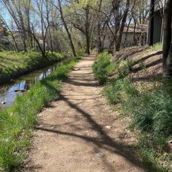
This wide and flat trail offers beautiful scenery of Watson Woods riparian area, Watson Lake and the Dells. It makes for an easy hike, bike ride, or on rare occasions even a cross country ski, which we just completed after a late February storm. If you chose to ski it, get out early in the day - like 8 am as the trail is fully exposed and even if the temp is below freezing the sun will melt your tracks. Ski wax is also highly recommended. The parking lot is near the refuse transfer station and requires a $3 fee paid by credit card at the kiosk, or is free on Wednesdays. The first tenth of a mile northbound skirts by the refuse station so can be noisy and dusty in the summer, but after that the riparian area, lake and boulders provide great opportunities for photography or just relaxing on one of the many benches. You can also head south along the river bed area of the preserve or cross the preserve to the west and north to Watson Lake. There are several trail map signs posted throughout to help guide you on your trek. This is a popular trail so can get busy, but you can still loose yourself along the river area or further north if you take off on side trails.

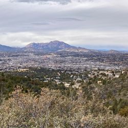
I learned about this trail while at the main part of the Watson lake trail as a good place to come for sunrise and sunset. Trail opens at 6am and a pay station is available a few minutes before 6am. I arrived at 5am and unable to use the machine, I went in without payment and paid when I got back to the parking shortly before 6am. Since the trail is located to the east of the lake, I think it would have been good to come for sunset. Trail is well maintained and I saw several runners after the sunrise. Now I know of this trail, I need to plan another visit to Prescott to capture beautiful sunset here

We did the Peavine Trail this morning. It was a nice flat trail and we saw a few other hikers and mountain bikers. There are plenty of trail maps along the way to make sure you stay on track. We didn't go to the end of the Peavine Trail but it is 6 miles (one-way). There are four other trails that connect to the Peavine Trails (Lower granite creek trail, Lakeshore trail, Iron king trail, and Flume trail) so you can really access the trail from all directions. The Peavine Trail does not get you close to Watson Lake, take the Lakeshore Trail or Flume Trail if you want a closer glimpse of the lake. We also took the Lakeshore Trail detour to get a closer glimpse of Watson Lake with Granite Dells in the background. It was neat that the Lakeshore Trail had white painted dots to help guide you through the rocky areas. You do have to climb a few rocks but nothing too hard. My 6yo daughter managed to do the climbs with ease. As for parking, we parked in a dirt parking lot off of Sundog Dance Road. There were plenty of available parking. We went on a Friday morning. Parking is $3. Being cash in case the card reader doesn't work as that is what happened to us.

Such an amazing trail. We rode our bikes and went about 10 miles RT. $3 to park and pick up a map at the trailhead. Best park maps ever- way to go Prescott! Flat trail with slight incline and crushed gravel all the way. This is the old railway, and be sure to read the trail signs for a bit of history. Again, well done trail managers. Be aware there's an outdoor police training area so you may hear gunfire, as we did. A few minutes into the trail you pass through a juniper grove and the scent is divine. Shortly after that you see Watson lake and then the trail passes through the "flintstone" rocks. See pics for views. We saw a horn toad and a horned lizard. This is a perfect trail for folks who aren't too sure-footed. For those more adventurous, there are several hiking trails that shoot off the main trail.

Took an e-bike on this trail and had so much fun! The dirt and gravel path is well maintained and easy to ride, with beautiful views along the way. There are incredible rock formations, lush greenery, and scenic lake views throughout. We also came across some old rail cars that make for a really cool photo op. Definitely a great ride! read more


This hiking, walking, biking, horse trail is a gem. We had our e-bikes, so that is how we chose to experience it. There is a large parking lot that costs $5, or you can buy an annual pass that gets you into other area parks as well. It is mostly flat, mostly dirt/rock. There were a few off-shoots we could've taken. There was a porta-potty a ways in. The scenery is spectacular, with stunning rock formations, and some sections showing you the gorgeous Watson Lake. It was used by lots of walkers, a couple of joggers, several bikes, and even a horse. Fun morning. read more


5 months ago
We arrived here before 11 a.m. on a Sunday morning. The trailhead is located about 2 - 3 miles from Prescott, just off a main highway. There is a sizeable parking lot which charges $3 per day. There is also a bike repair station and restrooms at the trailhead. We walked for about an hour. You first head downhill to the lake level and spend the first 1/3 mile or so getting to the lake. You then hike along the lake until a spur trail offers the opportunity to hug the shoreline and scramble over some rocks. It wasn't too challenging, but it was also not a completely level trail. The scenery is nice - the lake, odd boulder formations, occasional wildlife (including a bald eagle!), some ranchers fixing a fence just off one trail, and a fair number of bikers (both manual and electric) on the main trail. This was a worthwhile stop and we all enjoyed our hike here. read more


This wide and flat trail offers beautiful scenery of Watson Woods riparian area, Watson Lake and the Dells. It makes for an easy hike, bike ride, or on rare occasions even a cross country ski, which we just completed after a late February storm. If you chose to ski it, get out early in the day - like 8 am as the trail is fully exposed and even if the temp is below freezing the sun will melt your tracks. Ski wax is also highly recommended. The parking lot is near the refuse transfer station and requires a $3 fee paid by credit card at the kiosk, or is free on Wednesdays. The first tenth of a mile northbound skirts by the refuse station so can be noisy and dusty in the summer, but after that the riparian area, lake and boulders provide great opportunities for photography or just relaxing on one of the many benches. You can also head south along the river bed area of the preserve or cross the preserve to the west and north to Watson Lake. There are several trail map signs posted throughout to help guide you on your trek. This is a popular trail so can get busy, but you can still loose yourself along the river area or further north if you take off on side trails. read more


I learned about this trail while at the main part of the Watson lake trail as a good place to come for sunrise and sunset. Trail opens at 6am and a pay station is available a few minutes before 6am. I arrived at 5am and unable to use the machine, I went in without payment and paid when I got back to the parking shortly before 6am. Since the trail is located to the east of the lake, I think it would have been good to come for sunset. Trail is well maintained and I saw several runners after the sunrise. Now I know of this trail, I need to plan another visit to Prescott to capture beautiful sunset here read more

We did the Peavine Trail this morning. It was a nice flat trail and we saw a few other hikers and mountain bikers. There are plenty of trail maps along the way to make sure you stay on track. We didn't go to the end of the Peavine Trail but it is 6 miles (one-way). There are four other trails that connect to the Peavine Trails (Lower granite creek trail, Lakeshore trail, Iron king trail, and Flume trail) so you can really access the trail from all directions. The Peavine Trail does not get you close to Watson Lake, take the Lakeshore Trail or Flume Trail if you want a closer glimpse of the lake. We also took the Lakeshore Trail detour to get a closer glimpse of Watson Lake with Granite Dells in the background. It was neat that the Lakeshore Trail had white painted dots to help guide you through the rocky areas. You do have to climb a few rocks but nothing too hard. My 6yo daughter managed to do the climbs with ease. As for parking, we parked in a dirt parking lot off of Sundog Dance Road. There were plenty of available parking. We went on a Friday morning. Parking is $3. Being cash in case the card reader doesn't work as that is what happened to us. read more


Such an amazing trail. We rode our bikes and went about 10 miles RT. $3 to park and pick up a map at the trailhead. Best park maps ever- way to go Prescott! Flat trail with slight incline and crushed gravel all the way. This is the old railway, and be sure to read the trail signs for a bit of history. Again, well done trail managers. Be aware there's an outdoor police training area so you may hear gunfire, as we did. A few minutes into the trail you pass through a juniper grove and the scent is divine. Shortly after that you see Watson lake and then the trail passes through the "flintstone" rocks. See pics for views. We saw a horn toad and a horned lizard. This is a perfect trail for folks who aren't too sure-footed. For those more adventurous, there are several hiking trails that shoot off the main trail. read more


4 years ago
8 years ago
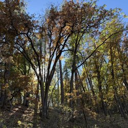
My boyfriend and I really enjoyed hiking here. The colors and scenery were beautiful. Only 3 dollars to park for the whole day. read more

More info about Peavine Trail
1626 Sundog Ranch Rd
Prescott, AZ 86301
Directions
Hours
Outdoor Amenities
Ask the Community - Peavine Trail
Review Highlights - Peavine Trail


Peavine Trail - parks - Updated July 2026
Best of Prescott
People found Peavine Trail by searching for…
Watch Sunset in Prescott, Arizona
Scenic View in Prescott, Arizona
Things to Do in Prescott, Arizona
River Swimming in Prescott, Arizona
Off Road Trails in Prescott, Arizona
Parks for Kids in Prescott, Arizona
Places to Take Pictures in Prescott, Arizona
Sunset View in Prescott, Arizona
Hiking Trails in Prescott, Arizona
Scenic Overlook in Prescott, Arizona
Walking Trails in Prescott, Arizona
Fun Things to Do at Night in Prescott, Arizona
Playgrounds for Kids in Prescott, Arizona
Playgrounds in Prescott, Arizona
Sunrise View in Prescott, Arizona
Scenic Drive in Prescott, Arizona
Beautiful Views in Prescott, Arizona
Places to Walk Around in Prescott, Arizona
Skyline View in Prescott, Arizona
Tennis Court in Prescott, Arizona
Cliff Diving in Prescott, Arizona
Trending Searches in Prescott, AZ
Browse Articles
Browse Nearby
BEST of Prescott, Arizona Coffee near Peavine Trail
BEST of Prescott, Arizona Restaurants near Peavine Trail
BEST of Prescott, Arizona Playgrounds near Peavine Trail
BEST of Prescott, Arizona Things to Do near Peavine Trail
BEST of Prescott, Arizona Star Gazing near Peavine Trail
BEST of Prescott, Arizona Breakfast near Peavine Trail
BEST of Prescott, Arizona Picnic Areas near Peavine Trail
Browse Brands
Related Searches in Prescott, AZ
Best Off Leash Dog Parks in Prescott, Arizona
Best Parks for Parties and Events in Prescott, Arizona
Best Water Parks for Kids in Prescott, Arizona
Check Out Great Playgrounds in Prescott, Arizona
Discover Baseball Fields Around Prescott, Arizona
Discover Free Parking Options in Prescott, Arizona
Discover Fun Toddler Parks in Prescott, Arizona for Your Little One
Discover Popular Photo Spots in Prescott, Arizona
Discover Top Nature Parks to Visit in Prescott, Arizona
Discover the Best Beaches in Prescott, Arizona
Discover the Best Kids Park Spots in Prescott, Arizona
Enjoy the Best Walking Trails in Prescott, Arizona
Explore Beautiful Botanical Gardens in Prescott, Arizona
Explore Easy Hikes Perfect for All in Prescott, Arizona
Explore Family-Friendly Zoos and Wildlife in Prescott, Arizona
Explore Free Picnic Areas Around Prescott, Arizona
Explore Fun Activities to Do in Prescott, Arizona
Explore Parks With Pull Up Bars in Prescott, Arizona
Explore Pickleball Courts in Prescott, Arizona
Explore Popular Campgrounds Near Prescott, Arizona
Explore Popular Picnic Areas Around Prescott, Arizona
Explore Popular RV Parks Around Prescott, Arizona
Explore Popular Recreation Centers Around Prescott, Arizona
Explore Scenic Lakes to Visit in Prescott, Arizona
Explore Top Dog Parks in Prescott, Arizona Near You
Explore Top Gyms in Prescott, Arizona Now
Explore Top Water Parks in Prescott, Arizona Today
Explore the Best Swimming Holes Around Prescott, Arizona
Find Top Skate Parks in Prescott, Arizona for All Skill Levels
Find Top Skating Rinks in Prescott, Arizona for All Ages
Find a Park With BBQ Pits in Prescott, Arizona
Find the Best Parks BBQ Grills in Prescott, Arizona
Find the Best Parks for Picnics in Prescott, Arizona
Find the Best Swimming Pools in Prescott, Arizona Today
Fun Things for Kids in Prescott, Arizona
Great Places to Swim in Prescott, Arizona
Have Fun at a Splash Pad in Prescott, Arizona
Indoor Playgrounds to Explore in Prescott, Arizona
Must-See Tourist Attractions Around Prescott, Arizona
Picnic Areas With BBQ Pits Available in Prescott, Arizona
Popular Fishing Spots to Explore in Prescott, Arizona
Popular Kids Activities in Prescott, Arizona
Popular Outdoor Activities to Try in Prescott, Arizona
Popular Places to Take Pictures in Prescott, Arizona
Top Hiking Trails to Explore in Prescott, Arizona
Top Running Trails to Explore in Prescott, Arizona
Top Swimming Lakes to Enjoy in Prescott, Arizona
Top Things to Do With Kids in Prescott, Arizona