Parker Ridge Photos


More like Parker Ridge
Recommended Reviews - Parker Ridge
Start your review...

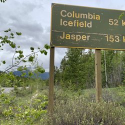
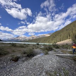
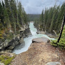
Parker Ridge is one of the main/primary/popular hikes in this Columbia Icefield/Athabasca Glacier area right on the border of Banff and Jasper National Parks. The trailhead is situated off famous Icefields Parkway and in fact...Parker Ridge is extremely similar in aspects to another well known hiking trail nearby...and that being Wilcox Pass. I would like to (for a moment) compare both this Parker Ridge and Wilcox Pass. If you gave me a choice for which hike to pick as better...I'd rank them pretty equally. Both are similar in distances, elevations, terrains, difficulties and offer similar settings. In a way, they're mirror images of each other. Yet, the hiker receives different observation levels of views. And btw...both trails are located roughly 5 kilometers away from each other. To describe the hikes... Wilcox Pass "rises quickly above the tree line to expansive meadows of the glacially-carved landscape offering stunning views of Athabasca Glacier", according to the sign at the trailhead. This Parker Ridge "after a series of switchbacks, you'll be rewarded with dramatic views of the Saskatchewan Glacier and headwaters of the North Saskatchewan River" according to the trailhead sign here. The biggest difference between the hikes was evident in my eyes... Wilcox Pass is situated on the EAST side of the road, whereas... Parker Ridge begins on the opposite side of Icefields Parkway (the WEST side) and offers hikers two distinct perspectives looking out upon Hilda Peak, Hilda Glacier, Nigel Peak and the Nigel Valley Mountain Range...and of course, beautiful Saskatchewan Glacier. In the end, you can't go wrong with whatever hike you take, or even choosing both if you have the time. I'd like to give more details about this Parker Ridge Trail... It's a 4.2 kilometer (2.8 mile) roundtrip hike gaining 250 meters (820 feet) in elevation. I'd rate the hike as moderately difficult. The first part of the hike is nothing but switchbacks as you gain elevation pretty fast immediately leading to views of the east side of the Columbia Icefield landscape. Then, you level off and the pathway leads to the edge of Big Bend Peak, Cirrus Mountain, Mount Athabasca and Castleguard Mountain with Saskatchewan Glacier situated off to the right hand side. Now...I visited here in late September during sunset time and it was freezing out with winds being pretty gusty. Had I not been in a hurry to complete the hike before dark, I would have struggled with the bitter cold. But because I rushed the hiking, I didn't feel the effects of the temperature drop. And interestingly, for this time of year it got dark early at 6pm. My one big problem with the scenery was...(and I've mentioned countless times in prior reviews, lol) for late afternoon, the sun quickly set upon the mountains and Saskatchewan Glacier. Due to this, it made photogenic opportunities hard to come by. And as I always suggest, lol...I believe visitors would be best served doing the hike in the morning time where the sun would be positioned on the east side of Icefields Parkway assisting in glistening the countryside. And btw...same goes for Wilcox Pass... MORNING TIME IS A MUST for that hike. Ultimately, my pictures came out okay. I'm not bitter...but they could have been better. Lastly, towards the end of this Parker Ridge Trail...the pathway navigated along the edge of the mountainside. In fact...I actually found myself crouching down and doing some slight scrambling. I just became cautious in the moment as the winds were howling while heading towards the pinnacle/apex of it all. As a mindful measure, I decided not to complete the hike because it never hurts to be on the safe side. In the end...I had already taken enough pictures and felt satisfied getting familiar with the lay of the land. I was fine with returning back down to reach the parking lot before it got pitch dark outside. In total, I used 2.5 hours to hike the trail. Had it not been so late in the day and so cold...I could have taken half the day to leisurely take my time. Overall, Parker Ridge Trail is a worthwhile hike where you'll be afforded undisturbed views of the Columbia Icefield portion in between Banff and Jasper National Parks. So, yeah, you can also hike Wilcox Pass while here as well as...taking a bus ride out onto Athabasca Glacier which is the most popular activity for casual tourists. read more
. - Hiking Near Me - Nordegg, Alberta")


3 years ago
More info about Parker Ridge
AB-93
Nordegg, AB T0M 2H0
Canada
Directions
Hours
Outdoor Amenities