1. North Hills Park

0

Raleigh, NC

Cancel

Open app

Search

North Hills Park

4.7 (3 reviews)

North Hills Park Photos
You might also consider

Recommended Reviews - North Hills Park

Your trust is our priority, so businesses can't pay to alter or remove their reviews. Learn more about reviews.
Yelp app icon
Browse more easily on the app
Review Feed Illustration

2 years ago

Helpful 0
Thanks 0
Love this 0
Oh no 0
Photo of Holly K.
3309
2036
7412

6 years ago

Helpful 13
Thanks 0
Love this 11
Oh no 0

5 years ago

Helpful 0
Thanks 0
Love this 0
Oh no 0

You might also consider

Verify this business for free

People searched for Playgrounds 753 times last month within 15 miles of this business.

Verify this business

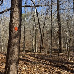
William B Umstead State Park - Pott's Branch Trail, orange diamond. Well marked trail! - December 2025

William B Umstead State Park

4.6(185 reviews)
6.3 mi

I came across William B Umstead State Park while staying in a nearby hotel for business. I am…read morealways looking for somewhere peaceful to walk or run when I have the time and so happy to have found this park nearby. I came to find out that the park covers thousands of acres and has all kinds of trails. The entrance I utilized on foot required my constant attention after crossing over the interstate as the sidewalk vanishes and I had to make sure I was on the shoulder to make sure I didn't get squished by cars going into and out of the park. It wasn't that difficult but be aware if you are entering the park on foot from the nearby SAS campus (of which I understand Umstead along with a friend started). There's lots of parking from this entrance and a few trails to choose from. I took the Loblolly trail from the Reedy Creek entrance. It is fairly long at around 7 miles out. It's not a loop. I did about a mile and a quarter of the trail and it was awesome. All covered with a tree canopy the trail is well marked and maintained. It ranged from gravel to vines and rocks to bare dirt. Great scenery and very peaceful. There's enough room to pass other walkers and hikers. I really enjoyed this park. I want to explore it more if I'm in the area again as I had time constraints. I highly recommend this well maintained park and will visit again. Nothing quite like a good walk in nature. Enjoy!
Wonderful trails for biking, hiking, walking (and also some trails are sign-posted to allow…read morehorses). Not crowded. Miles & miles of trails. Picnic tables and pavilions. Creeks and streams. Lakes and ponds. Boating. BE AWARE of closed trails, bridges, etc...stop by the park office AND check the website for closures.

Photos
William B Umstead State Park

See all

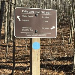
Mountains To Sea Trail - Blazes

Mountains To Sea Trail

5.0(2 reviews)
1.5 mi

I think it's the coolest thing that NC has a cross-state trail that allows you to experience the…read morevast range of natural landscapes the state has to offer. This trail, as the name claims, goes from mountains to sea (the trail is best known as the MST). It's cool enough that the state has all of this, even better that a trail connects them. You could hike this 1,175 mile trail from the highest point east of the Mississippi (Mt. Mitchell) down to sea-level at Cape Hatteras National Seashore. The trail passes through several state parks, national forests and national parks, not to mention some of the most significant urban centers in the state. There are paddle sections, dirt trails and paved roads - all manner of surfaces. The trail isn't even truly considered complete yet, but you can piece it together as you go. The idea has existed since the 70s and was officially added to the state park system - and the passport program - in 2000. The trail is about half the length of the AT - which it intersects at the beginning, by the way - but fits entirely in the state. It gives you a good idea of just how long it is. I actually only found out about this trail recently despite its age. This is no surprise, as it passes through the north part of the state and I've spent my entire life in the two largest cities it doesn't pass through in the southern part of the state. Somehow this just makes the idea even more novel to me. If you don't know about this trail, read up! Get out there and hike it in one of the 10 state parks it touches. Or, chances are it even goes through your city or town already and, like me, you just didn't know. It will be cool to connect with a piece of Earth that connects the entire length of the state.

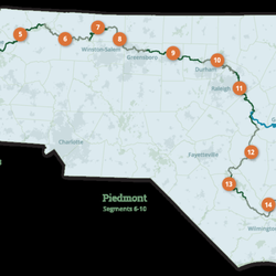
An 18 segment trail from Clingmans dome to Jockey's ridge State Park. Segment 1-5 is in the…read moremountains, segment 6-10 is Piedmont, and segment 11-18 is the costal plains and OuterBanks. There is an alternate route from 11A to 16A that is 170 mile paddle route down the Neuse River. Each segments distance varies. Levels of difficulty vary from strenuous to easy. What a fantastic way to see NC. I have not Thru hiked the trail. I have only done portions of segments. I am planning on doing whole segments to complete the entire 1200 mile distance. As well as the paddle portion. Clingmans dome is the second highest point on the east coast at 6,643 feet and what an amazing view. You will cross over Mt Mitchell which is the highest point on the east coast at 6,684 feet. To Jockey's Ridge Dune the largest and tallest active dune in the eastern United States. There are section that take you down paved roads to reconnect with the trail and a couple ferry rides in the outer banks. Places to camp if you do multi day trip, but plan your stops accordingly and research the trail angels for each segment. Explore what NC has to offer, even small sections with-in a segment. And just maybe we will see you on the trail or river. Happy Hiking :-)

Photos
Mountains To Sea Trail
Mountains To Sea Trail - Trail Map with Segment Indicators

See all

Trail Map with Segment Indicators

North Hills Park - playgrounds - Updated October 2026

Loading...
Loading...
Loading...