Anderson Point Park Photos


You might also consider
More like Anderson Point Park
Recommended Reviews - Anderson Point Park
Start your review...

Reviews With Photos

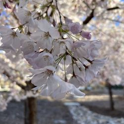
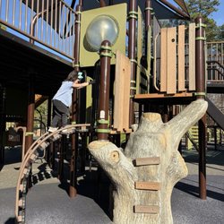
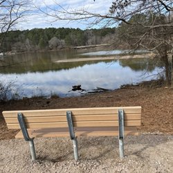
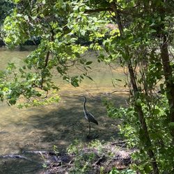
Though the Anderson Point Park was founded in 1988, the Neuse River Corridor Park Plan took a giant step toward completion with the dedication of Anderson Point Park's 98.3 acres adjacent to the Neuse River in 2000. What I wish the photos would show you is how vast the Neuse River Trails really are and how much the planners really utilized that span of acres. I wonder if someone could even walk all of them in one day. I've been out on the trails twice now and have yet to see an end in sight. The park seems to center around three main attractions: a large meadow and a few surrounding fields which house a variety of local wildlife and protect their natural habitats, the Anderson Family Homestead from the early 1900's and the scenic overlook of and surrounding trails of the Neuse River Trails. The park's shortcoming is really the lack of parking. There is only one small lot which was full on the first occasion I wandered out here to the point that I couldn't even park and had to leave. The trails could also use some better markings. I realize it's not in an area that gets a lot of traffic in terms of park visitors outside of those who live in the neighboring communities, but I really adore the landscape. I have walked around just taking in the scenery. I saw a pickup soccer game near the playground. I imagine the old Anderson Homestead is used for many special events. If you look in the window you'll see hardwood floors, bookshelves with old books, and open airy rooms. Go down the Neuse River Trail in any which way and it seems to go on forever. However, if you continue to follow the loop around, you'll see a nice birdhouse, a grove of trees carefully manicured with some benches, a straggly overgrown area with a path winding up to more overgrowth with benches, and other large open fields beckoning back to other sunny views. A couple was out walking their Pomeranian, mothers walking with their small children, and men cycling in and out of the park. There are natural amphitheater setups if you want to get some people together and then there are a couple of official shelters. It's not huge, but it's vast at the same time...Beautiful sunshine and plenty of places to plop down and relax.

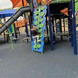
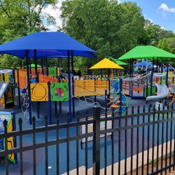
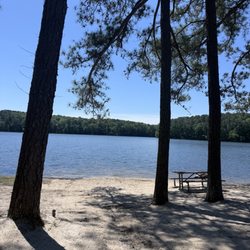
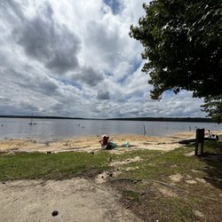
Great, beautiful spot for biking, running and walking. The bathroom facilities are clean (and now open) There are plenty of parking spaces. A beautiful playground and plenty of space to roam around. The park connects to the Neuse River Trail, the Crabtree Creek Trail and a few others. You can easily spend hours on the trails. Unfortunately not too many shaded spots on the nearby trails - especially because of some new housing. read more

5 years ago
13 years ago
Though the Anderson Point Park was founded in 1988, the Neuse River Corridor Park Plan took a giant step toward completion with the dedication of Anderson Point Park's 98.3 acres adjacent to the Neuse River in 2000. What I wish the photos would show you is how vast the Neuse River Trails really are and how much the planners really utilized that span of acres. I wonder if someone could even walk all of them in one day. I've been out on the trails twice now and have yet to see an end in sight. The park seems to center around three main attractions: a large meadow and a few surrounding fields which house a variety of local wildlife and protect their natural habitats, the Anderson Family Homestead from the early 1900's and the scenic overlook of and surrounding trails of the Neuse River Trails. The park's shortcoming is really the lack of parking. There is only one small lot which was full on the first occasion I wandered out here to the point that I couldn't even park and had to leave. The trails could also use some better markings. I realize it's not in an area that gets a lot of traffic in terms of park visitors outside of those who live in the neighboring communities, but I really adore the landscape. I have walked around just taking in the scenery. I saw a pickup soccer game near the playground. I imagine the old Anderson Homestead is used for many special events. If you look in the window you'll see hardwood floors, bookshelves with old books, and open airy rooms. Go down the Neuse River Trail in any which way and it seems to go on forever. However, if you continue to follow the loop around, you'll see a nice birdhouse, a grove of trees carefully manicured with some benches, a straggly overgrown area with a path winding up to more overgrowth with benches, and other large open fields beckoning back to other sunny views. A couple was out walking their Pomeranian, mothers walking with their small children, and men cycling in and out of the park. There are natural amphitheater setups if you want to get some people together and then there are a couple of official shelters. It's not huge, but it's vast at the same time...Beautiful sunshine and plenty of places to plop down and relax. read more


7 years ago
Stopped here to get my run in today. Pretty hilly with some good views of the park. Park itself not to big but it is connected to the Neuse River Trail. read more


9 years ago
Anderson Point Park is true hidden gem. I was riding my bicycle on the Neuse River Trail and I stumbled upon this serene piece of Heaven. There is a playground for the kids, benches for the adults, bike pumps, bathrooms, grills, and few quiet spots to snuggle with that someone special in your life. The hustle and bustle of life is left outside of this place. Let's go celebrate our new found happiness. read more


12 years ago
6 years ago
9 years ago
10 years ago
10 years ago
More info about Anderson Point Park
Ask the Community - Anderson Point Park
Review Highlights - Anderson Point Park


Anderson Point Park - hiking - Updated July 2026
Best of Raleigh
People found Anderson Point Park by searching for…
Beautiful Views in Raleigh, NC
Basketball Courts in Raleigh, NC
Places to Take Pictures in Raleigh, NC
Things to Do With Kids in Raleigh, NC
Kids Indoor Play Area in Raleigh, NC
Off Road Trails in Raleigh, NC
Fun Things to Do in Raleigh, NC
Kids Birthday Party Venues in Raleigh, NC
Scenic Overlook in Raleigh, NC
Trending Searches in Raleigh, NC
Blueberry Picking near Anderson Point Park
Boating near Anderson Point Park
Cliff Jumping near Anderson Point Park
Cruising Spots near Anderson Point Park
Day Trips near Anderson Point Park
Dog Friendly Things To Do near Anderson Point Park
Flower Fields near Anderson Point Park
Free Picnic Areas near Anderson Point Park
Indoor Playgrounds near Anderson Point Park
Jet Skis near Anderson Point Park
Kayak Rental near Anderson Point Park
Kids Activities Indoor near Anderson Point Park
Lakes near Anderson Point Park
Lookout Points near Anderson Point Park
Off Road Trails near Anderson Point Park
Outdoor Activities near Anderson Point Park
Outdoor Basketball Courts near Anderson Point Park
Parks near Anderson Point Park
Parks With Pull Up Bars near Anderson Point Park
Peach Picking near Anderson Point Park
Picnic Spots near Anderson Point Park
Public Running Track near Anderson Point Park
River Swimming near Anderson Point Park
Rock Quarry near Anderson Point Park
Rope Swing near Anderson Point Park
Scenic Overlook near Anderson Point Park
Splash Pad near Anderson Point Park
Sunrise View near Anderson Point Park
Surf Shop near Anderson Point Park
Swimming Holes near Anderson Point Park
Things To Do On A Rainy Day near Anderson Point Park
Toddler Activities near Anderson Point Park
Toddler Birthday Party Venues near Anderson Point Park
U Pick Farms near Anderson Point Park
Watch Sunset near Anderson Point Park
Water Parks near Anderson Point Park
Browse Nearby
BEST of Raleigh, North Carolina Coffee near Anderson Point Park
BEST of Raleigh, North Carolina Restaurants near Anderson Point Park
BEST of Raleigh, North Carolina Things to Do near Anderson Point Park
BEST of Raleigh, North Carolina Breakfast near Anderson Point Park
BEST of Raleigh, North Carolina Parks near Anderson Point Park
BEST of Raleigh, North Carolina Shopping near Anderson Point Park
BEST of Raleigh, North Carolina Taxis near Anderson Point Park
Browse Brands
Related Searches in Raleigh, NC
Affordable Kayak Rental Services in Raleigh, North Carolina
Best Fishing Locations and Guides in Raleigh, North Carolina
Best Kids Birthday Places to Celebrate in Raleigh, North Carolina
Best Kids Playgrounds to Visit in Raleigh, North Carolina
Best Parks for Parties and Events in Raleigh, North Carolina
Best Places for Horseback Riding in Raleigh, North Carolina
Best Play Place Options for Families in Raleigh, North Carolina
Best Water Parks for Kids in Raleigh, North Carolina
Check Out Off Road Trails in Raleigh, North Carolina
Discover Dog Friendly Trails to Explore in Raleigh, North Carolina
Discover Fun Kid Activities to Enjoy in Raleigh, North Carolina
Discover Fun Toddler Parks in Raleigh, North Carolina for Your Little One
Discover Kid Friendly Hiking Trails in Raleigh, North Carolina
Discover Kids Indoor Play Area Venues in Raleigh, North Carolina
Discover Popular Bike Trails in Raleigh, North Carolina
Discover Scenic Mountain Bike Trails Near Raleigh, North Carolina
Discover Soccer Fields in Raleigh, North Carolina Near You
Discover a Hiking Trail in Raleigh, North Carolina
Discover the Best Kids Park Spots in Raleigh, North Carolina
Discover the Best Night Hike Trails in Raleigh, North Carolina
Dog-Friendly Hikes With Dogs in Raleigh, North Carolina
Enjoy Camping Adventures Around Raleigh, North Carolina
Enjoy Kayaking Adventures in Raleigh, North Carolina
Enjoy Off Leash Dog Hikes in Raleigh, North Carolina
Enjoy Scenic Places to Walk in Raleigh, North Carolina
Enjoy Tent Camping Spots Around Raleigh, North Carolina
Enjoy a Beautiful Waterfall Hike in Raleigh, North Carolina
Enjoy the Best Mini Golf Courses in Raleigh, North Carolina
Enjoy the Best Picnic Spots and Ideas in Raleigh, North Carolina
Enjoy the Best Walking Trails in Raleigh, North Carolina
Explore Beautiful Parks and Green Spaces in Raleigh, North Carolina
Explore Children's Museums Near Raleigh, North Carolina
Explore Easy Hikes Perfect for All in Raleigh, North Carolina
Explore Free Kids Activities Near Raleigh, North Carolina
Explore Fun Activities to Do in Raleigh, North Carolina
Explore Outdoor Basketball Courts for All Skill Levels in Raleigh, North Carolina
Explore Popular Campgrounds Near Raleigh, North Carolina
Explore Popular Picnic Areas Around Raleigh, North Carolina
Explore Top Dog Parks in Raleigh, North Carolina Near You
Explore Top Trampoline Parks in Raleigh, North Carolina
Explore Top Water Parks in Raleigh, North Carolina Today
Explore Volleyball Courts Available in Raleigh, North Carolina
Explore the Best Beach Spots in Raleigh, North Carolina
Family Friendly Hiking With Kids in Raleigh, North Carolina
Find Beautiful Views in Raleigh, North Carolina
Find Popular Ziplining Spots Around Raleigh, North Carolina
Find Top Dog Friendly Parks to Visit in Raleigh, North Carolina
Find Top Kids Birthday Party Venues in Raleigh, North Carolina
Find Top Skate Parks in Raleigh, North Carolina for All Skill Levels
Browse Articles
People who viewed Anderson Point Park also viewed
William B Umstead State Park
185 reviews
White Deer Park/Garner Parks and Recreation
27 reviews
North Hills Park
3 reviews
Lake Johnson Park
150 reviews
Harold D Ritter Park
9 reviews
Lake Crabtree County Park
52 reviews
Capital Area Greenway
10 reviews
Honeycutt Park
10 reviews
Garner Recreational Park
3 reviews
White Oak Creek Greenway
3 reviews