Newfound Gap Photos


More like Newfound Gap
Recommended Reviews - Newfound Gap
Start your review...

Reviews With Photos

Beautiful stop on our way to Clingman's Dome. Great photos from several overlooks. Scenic views from the parking lot and also from a stone observation deck. Cool spot with a valley view of the great Smoky Mountains! This is located on the boundary line of North Carolina and Tennessee. The road is busy as there are great views without any hikes. Plenty of parking with restrooms. Definitely worth driving thru Newfound Gap round if you are in the vicinity.

Whilst driving through the Smokies via 441, don't pass by without stopping at this brief pull-off. I deem that besides the nearby Clingman's Dome, Newfound Gap has the prettiest views in all the National Park--particularly at sunset. You're at an elevation of 5,046 feet according to the sign, the highest easily accessible point by vehicle besides Clingman's Dome. The name comes after Indian Gap was originally the lowest mountain pass until 'Newfound' Gap replaced it--hence the name. A plaque designates the Smokey Mountains National Park as a World Heritage Site which allows it to be protected area due to "outstanding natural and cultural resources." Many visit the Rockefeller Memorial which is at the far end of the parking lot and is where former U.S. President Franklin D. Roosevelt formally dedicated the park on September 2, 1940. There is some neat art deco touches on the stone monument too. If you're a fan of the movie "A Walk to Remember," or think the idea of 'being in two places at once' is fun, you can step foot in both North Carolina and Tennessee at the same time across the state lines. Otherwise, the Appalachian Trail passes through here if you care to stroll part of it. The Charlies Bunion and Indian Gap trailheads also take off from here and it is a fairly safe spot to park your car.

Beautiful overlook with a large parking lot. In mid October it was VERY busy but we found a spot, and it was more empty when we returned from a hike. Nice high elevation of over 5k' so you'll get a good view on a clear day. We parked here for the Appalachian Trail trailhead to hike to Charlie's Bunion. This was about 8-9 miles round trip and it was strenuous to us, I consider us to be average to seasoned hikers. Lots of climbing and some rock scrambles. The view (assuming it's a clear day) from Charlie's Bunion is incredible. There are also several spots for great unobstructed views along the way. Be sure to bring lots of water and some snacks! We went on a VERY busy day and the trail was pretty packed considering the difficulty. It did thin out a bit as we went further along and likely wouldn't be too packed on off times. But we highly recommend the hike and the experience!

What a drive!!! It was out second to last day staying in Pigeon Forge, and it was a little rainy. We decided to go on a scenic drive and picked Newfound Gap. The views and drive were outstanding. If I knew it was going to be as pretty as it was I would have went on a more sunny day! The clouds opened up a few times, I think the mountains were able to break them up a little.

This is a mix of history, excitement to split 2 states, and simply another view of the Smokies. Some folks might not find it as exciting as I do, but I love it here and feel it is a must see. Newfound Gap is somewhere I have grown up coming to for my entire life. Every trip I have made to the Smokies, this is on the list of places I visit, my family visits, or that I bring people who have never experienced the Smokies and her grandeur. The Appalachian Trail comes through here. It's a nationally recognized trail that runs from Georgia to Maine. If you're lucky, you might run into people who are walking it. I saw a couple of hikers taking a break when visiting and had the chance to speak about their experiences hiking it. There is a massive parking lot that that accommodates the hoards of people who visit. Mind you, that it can get overcrowded, however, if you come later in the day - you are less likely to run into this problem. Come take in the views. You won't regret it.

Newfound Gap is one of the bigger vista points in GSMNP, situated right on the TN/NC state line. It's huge, with lots of parking, and gorgeous views in all directions. We lucked out during our visit, and it wasn't as crowded as it often can be. This is definitely a must-stop place when you're visiting the park.

Super highlight: this trailhead and outlook point has a considerably sized parking lot! This makes me feel much safer than at other lookout points and trailheads along the road through the Great Smoky Mountains National Park But be aware it is very popular and will probably be very crowded. The view over the gap is absolutely lovely. For those who hate being unplugged, there seems to be reliable cell service, at least in the main parking area and some of the start of the trail. There are facilities. Flushable, clean toilets, but no drinkable water so bring your own. Access to the Appalachian Trail, and trails that go to overlooks at Charlies Bunion and the Jumpoff point, can be found here. Absolutely worth a visit!

Newfound Gap at Great Smokey Mountains National Park in Bryson City is a beautiful and scenic portion of the park. I like that there is plenty of parking and restrooms as well as trails and overlooks. This area is well maintained and clean and is well worth and memorable it to experience it all.


WOW. Newfound Gap to Charlie's bunion is an amazing hike! We're not an avid hikers and do well with high elevation and most awesome views require a strenuous long 10+ mile hike in the smokies. We arrived at 9:30 and easily found parking and enjoyed breakfast and lunch and took our time on the hike. In the mornings it has been very foggy and Smoky but almost always clears up. It's great that it's out and back because we got the views on the way back! Once you hit Charlie's bunion it's such a treat!! But if you still have energy I recommend on the way back you hit the jump off! It's right off the boulevard trail. This part of the AT is amazing because at one point you're hiking on the ridge of a mountain overlooking other mountains. So fun and so doable. Ended up logging a little under 10 miles with the hike to Charlie's Bunion and adding the Jump off hike (quite literally a jump off if you take a few steps you will fall off the mountain!!)

3 months ago
Newfound Gap is a natural gap between the east and west sides of the Great Smoky Mountains. The Gap was important to early settlers on the region traveling across the mountains. From the Newfound overlook, we could see Gatlinburg, TN to the northwest and Cherokee, NC to the east. A sign at the site marks the line between Tennessee and North Carolina and is a fun photo stop. The Overlook is a MUST visit in the Park. Parking is inadequate, we circled the lot several times before finding a spot. Parking passes are required for parking in the National Park and can be purchased from kiosks at the Overlook. Plaques along the walkways are somewhat faded and difficult to read, but tell the story of the mountains and their inhabitants. A rock structure, half paid for by John D. Rockefeller, honors his late wife, Laura Spellman Rockefeller. We climbed the rock structure and enjoyed photo opts and breathtaking views of the mountains. Unfortunately, the structure is not wheelchair accessible. The Appalachian Trail crosses the Overlook. Trail support volunteers were onsite to assist hikers. There are a set of restrooms at the overlook. There are no other amenities at the site. read more


My legs were still angry at me from the climb to the top of Clingmans Dome so I didn't try to push myself to climb the Rockefeller Memorial here. But my pain didn't stop me from enjoying the view from the parking area which is tremendous. This is also the border between North Carolina and Tennessee. They have a sign. There is a "comfort station" here if you need to go. It's a long way to Gatlinburg! [Review 1170 of 2024 - 487 in Tennessee - 22193 overall] read more


5 years ago
Beautiful stop on our way to Clingman's Dome. Great photos from several overlooks. Scenic views from the parking lot and also from a stone observation deck. Cool spot with a valley view of the great Smoky Mountains! This is located on the boundary line of North Carolina and Tennessee. The road is busy as there are great views without any hikes. Plenty of parking with restrooms. Definitely worth driving thru Newfound Gap round if you are in the vicinity. read more


Whilst driving through the Smokies via 441, don't pass by without stopping at this brief pull-off. I deem that besides the nearby Clingman's Dome, Newfound Gap has the prettiest views in all the National Park--particularly at sunset. You're at an elevation of 5,046 feet according to the sign, the highest easily accessible point by vehicle besides Clingman's Dome. The name comes after Indian Gap was originally the lowest mountain pass until 'Newfound' Gap replaced it--hence the name. A plaque designates the Smokey Mountains National Park as a World Heritage Site which allows it to be protected area due to "outstanding natural and cultural resources." Many visit the Rockefeller Memorial which is at the far end of the parking lot and is where former U.S. President Franklin D. Roosevelt formally dedicated the park on September 2, 1940. There is some neat art deco touches on the stone monument too. If you're a fan of the movie "A Walk to Remember," or think the idea of 'being in two places at once' is fun, you can step foot in both North Carolina and Tennessee at the same time across the state lines. Otherwise, the Appalachian Trail passes through here if you care to stroll part of it. The Charlies Bunion and Indian Gap trailheads also take off from here and it is a fairly safe spot to park your car. read more


Beautiful overlook with a large parking lot. In mid October it was VERY busy but we found a spot, and it was more empty when we returned from a hike. Nice high elevation of over 5k' so you'll get a good view on a clear day. We parked here for the Appalachian Trail trailhead to hike to Charlie's Bunion. This was about 8-9 miles round trip and it was strenuous to us, I consider us to be average to seasoned hikers. Lots of climbing and some rock scrambles. The view (assuming it's a clear day) from Charlie's Bunion is incredible. There are also several spots for great unobstructed views along the way. Be sure to bring lots of water and some snacks! We went on a VERY busy day and the trail was pretty packed considering the difficulty. It did thin out a bit as we went further along and likely wouldn't be too packed on off times. But we highly recommend the hike and the experience! read more


6 years ago
What a drive!!! It was out second to last day staying in Pigeon Forge, and it was a little rainy. We decided to go on a scenic drive and picked Newfound Gap. The views and drive were outstanding. If I knew it was going to be as pretty as it was I would have went on a more sunny day! The clouds opened up a few times, I think the mountains were able to break them up a little. read more


7 years ago
This is a mix of history, excitement to split 2 states, and simply another view of the Smokies. Some folks might not find it as exciting as I do, but I love it here and feel it is a must see. Newfound Gap is somewhere I have grown up coming to for my entire life. Every trip I have made to the Smokies, this is on the list of places I visit, my family visits, or that I bring people who have never experienced the Smokies and her grandeur. The Appalachian Trail comes through here. It's a nationally recognized trail that runs from Georgia to Maine. If you're lucky, you might run into people who are walking it. I saw a couple of hikers taking a break when visiting and had the chance to speak about their experiences hiking it. There is a massive parking lot that that accommodates the hoards of people who visit. Mind you, that it can get overcrowded, however, if you come later in the day - you are less likely to run into this problem. Come take in the views. You won't regret it. read more


7 years ago
Newfound Gap is one of the bigger vista points in GSMNP, situated right on the TN/NC state line. It's huge, with lots of parking, and gorgeous views in all directions. We lucked out during our visit, and it wasn't as crowded as it often can be. This is definitely a must-stop place when you're visiting the park. read more

3 years ago
Super highlight: this trailhead and outlook point has a considerably sized parking lot! This makes me feel much safer than at other lookout points and trailheads along the road through the Great Smoky Mountains National Park But be aware it is very popular and will probably be very crowded. The view over the gap is absolutely lovely. For those who hate being unplugged, there seems to be reliable cell service, at least in the main parking area and some of the start of the trail. There are facilities. Flushable, clean toilets, but no drinkable water so bring your own. Access to the Appalachian Trail, and trails that go to overlooks at Charlies Bunion and the Jumpoff point, can be found here. Absolutely worth a visit! read more


6 years ago
Newfound Gap at Great Smokey Mountains National Park in Bryson City is a beautiful and scenic portion of the park. I like that there is plenty of parking and restrooms as well as trails and overlooks. This area is well maintained and clean and is well worth and memorable it to experience it all. read more


6 years ago
Amazing views when you get to the top. I highly recommend it. You get a smooth winding ride through trees and sometimes get a view of a rocky river. Great place to watch the sunrise or sunset. read more


5 years ago
6 years ago
WOW. Newfound Gap to Charlie's bunion is an amazing hike! We're not an avid hikers and do well with high elevation and most awesome views require a strenuous long 10+ mile hike in the smokies. We arrived at 9:30 and easily found parking and enjoyed breakfast and lunch and took our time on the hike. In the mornings it has been very foggy and Smoky but almost always clears up. It's great that it's out and back because we got the views on the way back! Once you hit Charlie's bunion it's such a treat!! But if you still have energy I recommend on the way back you hit the jump off! It's right off the boulevard trail. This part of the AT is amazing because at one point you're hiking on the ridge of a mountain overlooking other mountains. So fun and so doable. Ended up logging a little under 10 miles with the hike to Charlie's Bunion and adding the Jump off hike (quite literally a jump off if you take a few steps you will fall off the mountain!!) read more


6 years ago
10 years ago
Newfound Gap is a legendary overlook situated on the Tennessee/North Carolina border along Hwy 441, which passes through Great Smoky Mountains National Park between Cherokee, NC and Gatlinburg TN. It also intersects with the Appalachian Trail, a 2,168-mile hiking path front Springer Mountain in north Georgia all the way to Mount Katahdin in Maine. The views here (I must say) are not as spectacular as several other overlooks along this same stretch of mountain pass, but it is the only roadside overlook where you can see in two different directions for miles. Standing in the parking lot of Newfound Gap you can see southeast toward Cherokee, NC. or you can walk to the top of Rockefeller Memorial Overlook and view the distant mountain ranges northwest towards Knoxville, TN. The elevation @ Newfound Gap is approximately 5,048 feet as compared to nearby Clingman's Dome @ 6,644′ or the top of Mt. LeConte with an elevation of 6,594′, both of which require hiking to visit. Personally, I find the view from the parking area of Clingman's Dome to be one of the most spectacular in all of the Smoky Mountains. In our many travels to Gatlinburg from Atlanta, stopping at Newfound Gap is irresistible and practically a family tradition. The view is always the same (unless it rained recently), but here is where we spotted a black bear for the very first time in the wild. We've seen several since then all throughout the Smokies, but Newfound Gap was instantly imprinted on our hearts from that experience and we return mostly hoping to have another encounter. It is also significant to me because I dream of the day I will be passing this very spot on foot as I make my lifelong dream come true of hiking the entire Appalachian Trail in one season. Each time we visit, I look down the trail as it disappears into the woods, wonder if and when I will ever be able to get the chance to follow it. Distance calculators say from the Newfound Gap parking lot it would take me approximately 1,972 miles or roughly 4.5 months to reach my destination in Maine. Someday, health and finances permitting, I hope to see this dream achieved!!! FINAL THOUGHTS The Hwy 441 pass is open year round, but an occasional blizzard may shut it down for several hours or even days, so always check travel advisories when traversing this section of the Smokies between December and April. This overlook, as well as a dozen others, will have you stopping frequently for the many photo opportunities that show just why they've nicknamed these mountains the Blue Ridge. Never come this way without a camera and a child-like sense of adventure! Bring those two items and you will be justly rewarded! NOTE TO ALL MY ATLANTA AREA YELPERS - This overlook is only a 2.5 hour drive from The Mall of Georgia north on I-985, which turns into Hwy 441. It is well worth a weekend day trip!!! You will also pass Toccoa Falls, Tallulah Gorge, Clingman's Dome, the Indian village of Cherokee and Mingo Falls if you want to add another destination or two to your drive. 2016/60 read more


9 years ago
More info about Newfound Gap
Ask the Community - Newfound Gap
Review Highlights - Newfound Gap


Why does Yelp recommend reviews?
Newfound Gap - localflavor - Updated June 2026
Best of Bryson City
People found Newfound Gap by searching for…
Scenic Drive in Bryson City, North Carolina
Scenic View in Bryson City, North Carolina
Scenic Overlook in Bryson City, North Carolina
Watch Sunset in Bryson City, North Carolina
Photo Spots in Bryson City, North Carolina
Lookout Points in Bryson City, North Carolina
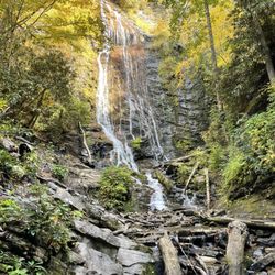
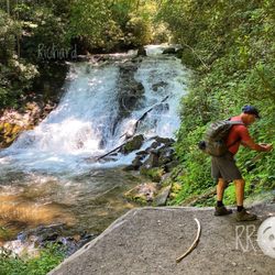
Waterfall in Bryson City, North Carolina
Places to Take Pictures in Bryson City, North Carolina
Things to Do in Bryson City, North Carolina
Things to Do on a Rainy Day in Bryson City, North Carolina
Sunset View in Bryson City, North Carolina
Running Trails in Bryson City, North Carolina
Tourist Attractions in Bryson City, North Carolina
Hidden Gems in Bryson City, North Carolina
Day Trips in Bryson City, North Carolina
Beautiful Views in Bryson City, North Carolina
Fun Things to Do at Night With Kids in Bryson City, North Carolina
National Parks in Bryson City, North Carolina
Night View in Bryson City, North Carolina
View Points in Bryson City, North Carolina
Open Early in Bryson City, North Carolina
Factory Tours in Bryson City, North Carolina
Browse Nearby
BEST of Bryson City, North Carolina Restaurants near Newfound Gap
BEST of Bryson City, North Carolina Breakfast near Newfound Gap
BEST of Bryson City, North Carolina Dinner near Newfound Gap
BEST of Bryson City, North Carolina Fishing near Newfound Gap
BEST of Bryson City, North Carolina Campgrounds near Newfound Gap
Browse Brands
Trending Searches in Bryson City, NC
Black Owned Nail Salons near Newfound Gap
Cliff Jumping near Newfound Gap
Fishing Spots near Newfound Gap
Jet Ski Rental near Newfound Gap
Kayak Rental near Newfound Gap
River Swimming near Newfound Gap
River Tubing near Newfound Gap
Strawberry Picking near Newfound Gap
Swimming Holes near Newfound Gap
Swimming Lakes near Newfound Gap