Mt. Daraitan Photos


Recommended Reviews - Mt. Daraitan
Start your review...

11 years ago
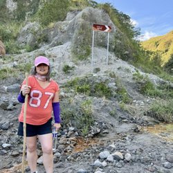
Scrolling down my Facebook and Twitter timeline, I noticed that a lot of young people like me are going to mountainous regions near Manila to try out hiking. I'm not really a fan of hiking or physical activities in general, but for some reason I got a bit jealous. I also wanted to go hiking with my friends as part of our yearly barkada goals. When my friend heard that I was interested in hiking, he immediately planned a trip to Tanay, Rizal. He told us that he knows this really cool place where we could hike. It took us 1 and a half hours to get to Tanay, Rizal. We first went to Brgy. Daraitan to contact a tour guide. When we finally found a tour guide for our day trip, we decided to head out to Mt. Daraitan. We only assigned one person from our barkada to take pictures, because we heard that a girl fell down the mountain while she was taking selfies (Yikes!). During our hike, there were many campsites and way points where we rested. There's also a super clean river down the mountain where some of my friends bathe in. If you want to visit an ecotourism site, you can take an alternate trail to Mt. Lugang, a beautiful mountainous region deep within Sierra Madre. This place will surely make you appreciate the beauty of mother nature. It was a very tiring adventure. At first, I was really scared, but the tour guide told me that I'll be safe as long as I follow all of his guidelines. This experience is definitely one for the books! read more


8 years ago
I was so amazed with how the river looks. Although the ride going to this scenic view is quite long and bumpy, its actually worth the wait. You have to go in groups though so you will not ripped off your pocket. Its also better if you have your own private car because the only means of transportation is trike going to barangay Daraitan. Just make sure the vehicle will endure the rocky road, literally its super bumpy and kinda steep. Also you have to pay for registrations, mandatory tour guide, bridge and so on.. that's why its better if you're in groups. Locals were nice and friendly though. read more


More info about Mt. Daraitan
Brgy Daraitan (Village Centre)
Tanay, 1980 Rizal
Philippines
Directions
0998-9881590
Call Now
Hours
Outdoor Amenities
Other Amenities


Why does Yelp recommend reviews?
Mt. Daraitan - campgrounds - Updated July 2026
Browse Brands
Browse Articles
Related Cost Guides
People who viewed Mt. Daraitan also viewed
Puerto Princesa Subterranean River National Park
7 reviews
Taguig City
Ayala Triangle Gardens
24 reviews
Makati City
Paco Park
7 reviews
Manila City
Quezon Memorial Circle
8 reviews
Quezon City
Marikina Freedom Park
2 reviews
Marikina City
Ortigas Park
4 reviews
Pasig City
Jaime C. Velasquez Park
6 reviews
Makati City
Pasig River Ferry
2 reviews
Ayala Alabang Village
2 reviews
Muntinlupa City
Washington Sycip Park
11 reviews
Makati City