Mount Davidson Park Photos


You might also consider
More like Mount Davidson Park
Recommended Reviews - Mount Davidson Park
Start your review...

Reviews With Photos


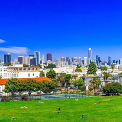
Amazing patk and hike on Myra Way in the middle of San Francisco. The hike was moderate skill level ypu will need decent shoes and it is slightly chilly at the top. We saw a coyote .The view at the top of San Francisco is stunning . You can see Mount Tam the Golden Gate , Berkeley, the entire city and the South Bay ! Sutro Tower and Twin Peaks can easily be seen . Highly recommend this hike and this view. 928 it the highest natural place in all of San Francisco and it geography is almost the center of San Francisco.Its the highest point proper but also a hidden gem ! Do the hike you won't be disappointed with the view. The cross is amazing .The Trees amazing.The views spectacular. Go do the hike ! Hope you summit.


Exquisite Hiking. Magnificent, San Francisco Views. Dirt Maintained Trails. Tranquil & Uncrowded. Free Residential Parking. Narrow Driving Road to & from Park. See Below for More Info: Exquisite Hiking: Mount Davidson Park offers exquisite hiking in the midst of San Francisco. It is such a hidden gem that I highly recommend to all. :) Magnificent, San Francisco Views: The views at Mount Davidson Park are magnificent, offering the highest point in the city. If your schedule allows, sunrise and sunset are stunning. Dirt Maintained Trails: Mount Davidson has several dirt trails, all of which are maintained. Yet, the hikes are on the shorter side at about one mile if you do a few trails. Hence, a great option if you are new into hiking or have kids. Tranquil & Uncrowded: The trail is tranquil and uncrowded making it an ideal place for some solo time or great for spending time with furry friends or other humans. Free Residential Parking: Free parking is available around the perimeter. Narrow Driving Road: The road to and from Mount Davidson is narrow, up and down many curvy, narrow hills. There will be points where you will have to pull to the side to let others cars by and vice versa. However, the view at the top will be worth it. :)

Nice place for a short hike in San Francisco. It's easy enough to do in sneakers and it's about 30-45 minutes to the top. There are some excellent views of the city on a clear day. Unfortunately today was not one of those days. Everything is free and there is parking in the neighborhoods surrounding multiple entrances. It's easy to get lost on the trails so have your maps or apps ready. There are no garbage cans or bathrooms so plan accordingly. It's worth a stop for an hour or so.


When I was a Junior at Lincoln High, I had my P.E. class as my first period and our teacher got us doing some sit-ups. While I was holding my classmate's legs as he was performing his set, he started farting every time he rose up from the mat as he squeezed his stomach and a rapid burst would follow. We had to stop as we busted out from laughing so hard that our P.E. teacher got annoyed at us and thought we were fooling around. As a result, he made as run 50 laps around the gym as punishment. I'm not a runner, nor am I built as a runner. My shins would hurt just after a few laps of running. But I prefer walking, and have developed a love for hiking as I got older. I can go at my own pace and can stop to smell the roses along the way. Growing up in the city, I have learned to appreciate the parks that are available for us to explore. Not far from Lincoln High is Mt. Davidson. We also used to come here went we went to Aptos Middle School after school just to see the cross at the top of this hill. It's a cool place to view the city, but we didn't come here for the view back then. Now, if you're into Urban Hiking, this is one of the places that you have to hit since it's pretty much smack dab in the middle of the city. There are several places where you can start your hike like on La Bica Way and Rockdale Drive from the North, Juanita Way from the West, Dalewood Way from the South and Molimo Drive from the East. You can start from any of these streets depending on if you can find street parking. But there are usually plenty of street parking available on Dalewood Way. Now, if you wanna skip the trail and just want to see the cross and the view, park along the intersections of Dalewood Way, Landsdale Avenue and Myra Way near the entrance on top of this hill. You will still need to hike uphill and go up some steps to reach the top, but this is the shortest way and pretty much a shortcut. But if you want to get the full experience, then start from any of the other entrances and take the trails until you reach the top destination. The reward will be worth it because of the beautiful view from up there. There's a sweeping view from Mt. Tamalpais to the left, Mt. Sutro, Twin Peaks, downtown then the East Bay. Depending on the weather, it could also rapidly change as Karl the Fog could roll-in in any moment. One minute it could be sunny then all of the sudden Karl is rolling in and covers everything in sight. But that's part of the beauty of this place as this is the highest point of San Francisco. Even higher than nearby Mt. Sutro and Twin Peaks. Now there are signs that there have been Coyote sightings in the area, but that's been the norm even before the pandemic hit. Just be careful and keep on eye on your four-legged companion if you bring 'em along. If you do spot a Coyote, maybe you can fart in their general direction to keep 'em away. #YelpChallenge2020 review No. 69

** The following review reflects my experience prior to the shelter-in-place order currently in effect. ** Well, hell's bells, I had never been here before last month, and I've been in the Bay Area most of my life. It's the highest point in the city, exactly three feet higher than Twin Peaks which gets all the glory and the tourists. You can't drive up here. No, the forty-acre park is laced with narrow, unmarked dirt trails which eventually make their way up to the summit amid overgrown vegetation. I got here by taking the MUNI train to the Forest Hill station and traipsing my way up Laguna Honda Blvd and after some wrong turns, onto the very residential Chaves Avenue. There was a nearly hidden brick stairway between two homes that provided my entrance (photo: https://bit.ly/2V2mSTb). At trail's end were panoramic views worthy of several Instagram moments. An unexpected sight was the nearly vertical street that I'm guessing inspired Wayne Thiebauld to paint his most famous streetscapes (photo: https://bit.ly/2JZNA8U). Believe it or not, I almost forgot to look at the cross. It's big alright and apparently Armenian and quite a big pilgrimage destination on Easter which prompted me to write this review now. Once this COVID-19 nightmare gets behind us, I look forward to taking the summit again. RELATED - Up for a hike? Here's a collection of places I've walked and later reviewed: https://bit.ly/2OrC8nU

We hiked here while in the area. This park is in located in a neighborhood, but easy to find using your GPS. The weather was absolutely perfect on the day we visited. Although we've had quite a wet winter, the dirt paths were not so muddy and dry. We parked in the neighborhood and started our ascent. It was about a good mile uphill to the cross. I'd say it is a moderate hike. It is all dirt and rock. It may be quite challenging for the little ones and older people. Overall it's a great place to come to get beautiful panoramic views of the city. Highly recommend!

I enjoy coming up here for a picturesque view of the city. You can get a really good pic of Sutro Towers and Twin Peaks together while you stand right in the middle! It's a great hike up. Depending on which side you come from, you may get your shoes a little muddy. A little mud never hurts anyone, just needs some water and towels! Plus there's grass for you to wipe the shoes on, near the top. There was a proposal here last time I went. Check out my attached picture. The happy couple and their friends left and never came back...after like taking pics for 5-10 mins. I was hanging out there for an hour after they left and was thinking wtf? They left a big bag of trash along with their expensive roses behind for the raccoons, maybe? Geez, what a waste! I grabbed the roses and cleared out the trash bags before I left. Dropped off the roses at my friend's place since they wanted them. Haha, their loss, my friend's gain.

Park on Dalewood Way and follow the winding dirt trail uphill to the giant cross. Your heart will pump a bit and you'll feel great being in the fresh air! It's a short walk--I checked my iPhone and it said we walked about 1.5 miles to and from. We also spent a bit of time checking out the other vantage points at the top. The views are wonderful from up there. There were signs indicating that coyote are out and about so be prepared. Mount Davidson represents the highest natural point in San Francisco at 928 feet. Does anyone remember the cross scene in "Dirty Harry"? It took over a month to film that overhead scene from the top of the cross looking down because of the fog! They finally got that shot in one night when the fog had cleared.

Went here for a Sunday 7am sunrise hike! Google Maps put us at the trailhead furthest from the top (poor planning on my part, not realizing there were multiple trails), so it was quite an adventure getting to the top by sunrise. The trail was narrow but well-established, and we ran across a jogger coming down from the top. In the final leg, there was a quite steep hill (in retrospect, might have been off trail, but we just picked paths via gradient ascent). The trail we came down through was quite wide. We passed by a mother, child, and very old dog coming up Remember there are multiple ways up the mountain :) We didn't try the other trails but Google Maps suggests there are lots of trails around the perimeter which get to this highest natural point in SF! The view was gorgeous, but my friend and I got six and three mosquito bites respectively in a short period of time (me just taking off my jacket a short while), so if mosquitos like you, put on some mosquito spray beforehand. At the top was a large cross commissioned by FDR remembering the 1915 Armenian Genocide. Mosquitos were sadly especially prevalent there. 3 base + 2 stars for view + 2 stars for trails - 2 stars for bugs = 5 stars

We parked on Dalewood Way(street parking ), and since we weren't there to get a workout , just wanted to get a view from the highest peak in the city , went up on a 1/4 mile trail to the peak where the huge cross stands. If you are wanting to get a really good workout, there are plenty of trails throughout the park. When we went on February 27, 2021 , there were a few California Poppies popping on the side of the hills. 360 degree view of the city and the bay is worth the drive but my favorite view is from the top of Bernal Heights , no offense to Mt Davidson , no view of the GGB that's why I knocked off one star.

Wow, what a nice spontaneous, surprise that my hubby took me here. We stopped to pick up take out an the spot did not have dine in so the hubby did a search on his phone, yay here we are Mount Davidson Park. Mt. Davidson Park is offers expansive views of the city, located 938 feet above sea level, the highest point in SF featuring a mix of eucalyptus forest. Note, there are no signage that its "Mount Davidson Park", its pretty hidden in a residential area, best is to follow your GPS map. We found a spot right next to the park and started hike up. A very quick hike up ( 9 mins) there you will see such stunning expansive views of the city skyline and the 103 foot concrete cross ( one of many photo opts here) The Cross = Sunrise Easter Cross First Service 1923. All in all, what a hidden gem, loved our quick visit to Mount Davidson, enjoyed our meal while we took in the views and even got to see variety of plant species, wildflowers, forest. Such a happy blessed moment with my love. * Note- there are no trash bins, please carry out all trash with you, I looked for a bin but didn't see any. read more


Each month my friends and I pick a new spot to hike/walk in the city & this one was fantastic. I love when you're in the city but it doesn't look or feel like it because of the lack of cars & noise. The scenery was green and fresh with some nice scents of eucalyptus. The views from the top are sensational. A great spot to picnic if you carry up your food in a backpack. The cross seems larger than life when you get close to it. Be sure to read the history of this park. read more


Really pretty short hike! Hours are 5am to midnight. Definitely recommend going at night time where you see the city lit up. Location: there's many different entrances to the park, the one that I like that has ample parking: 21 Dalewood Way, CA 94127. Not wheelchair or stroller accesible, if you're looking for one I would recommend just popping by twin peaks. Highly recommend. Cross is located all the way at the top read more

2 years ago
Amazing place to come and relax for a-little bit. You can just come hiking and stop at Mt. Davidson Cross. The view is amazing, you can see a big part of San Francisco Ca. I do recommend this place for everyone. read more


2 years ago
Amazing patk and hike on Myra Way in the middle of San Francisco. The hike was moderate skill level ypu will need decent shoes and it is slightly chilly at the top. We saw a coyote .The view at the top of San Francisco is stunning . You can see Mount Tam the Golden Gate , Berkeley, the entire city and the South Bay ! Sutro Tower and Twin Peaks can easily be seen . Highly recommend this hike and this view. 928 it the highest natural place in all of San Francisco and it geography is almost the center of San Francisco.Its the highest point proper but also a hidden gem ! Do the hike you won't be disappointed with the view. The cross is amazing .The Trees amazing.The views spectacular. Go do the hike ! Hope you summit. read more


Exquisite Hiking. Magnificent, San Francisco Views. Dirt Maintained Trails. Tranquil & Uncrowded. Free Residential Parking. Narrow Driving Road to & from Park. See Below for More Info: Exquisite Hiking: Mount Davidson Park offers exquisite hiking in the midst of San Francisco. It is such a hidden gem that I highly recommend to all. :) Magnificent, San Francisco Views: The views at Mount Davidson Park are magnificent, offering the highest point in the city. If your schedule allows, sunrise and sunset are stunning. Dirt Maintained Trails: Mount Davidson has several dirt trails, all of which are maintained. Yet, the hikes are on the shorter side at about one mile if you do a few trails. Hence, a great option if you are new into hiking or have kids. Tranquil & Uncrowded: The trail is tranquil and uncrowded making it an ideal place for some solo time or great for spending time with furry friends or other humans. Free Residential Parking: Free parking is available around the perimeter. Narrow Driving Road: The road to and from Mount Davidson is narrow, up and down many curvy, narrow hills. There will be points where you will have to pull to the side to let others cars by and vice versa. However, the view at the top will be worth it. :) read more


Nice place for a short hike in San Francisco. It's easy enough to do in sneakers and it's about 30-45 minutes to the top. There are some excellent views of the city on a clear day. Unfortunately today was not one of those days. Everything is free and there is parking in the neighborhoods surrounding multiple entrances. It's easy to get lost on the trails so have your maps or apps ready. There are no garbage cans or bathrooms so plan accordingly. It's worth a stop for an hour or so. read more


1 year ago


When I was a Junior at Lincoln High, I had my P.E. class as my first period and our teacher got us doing some sit-ups. While I was holding my classmate's legs as he was performing his set, he started farting every time he rose up from the mat as he squeezed his stomach and a rapid burst would follow. We had to stop as we busted out from laughing so hard that our P.E. teacher got annoyed at us and thought we were fooling around. As a result, he made as run 50 laps around the gym as punishment. I'm not a runner, nor am I built as a runner. My shins would hurt just after a few laps of running. But I prefer walking, and have developed a love for hiking as I got older. I can go at my own pace and can stop to smell the roses along the way. Growing up in the city, I have learned to appreciate the parks that are available for us to explore. Not far from Lincoln High is Mt. Davidson. We also used to come here went we went to Aptos Middle School after school just to see the cross at the top of this hill. It's a cool place to view the city, but we didn't come here for the view back then. Now, if you're into Urban Hiking, this is one of the places that you have to hit since it's pretty much smack dab in the middle of the city. There are several places where you can start your hike like on La Bica Way and Rockdale Drive from the North, Juanita Way from the West, Dalewood Way from the South and Molimo Drive from the East. You can start from any of these streets depending on if you can find street parking. But there are usually plenty of street parking available on Dalewood Way. Now, if you wanna skip the trail and just want to see the cross and the view, park along the intersections of Dalewood Way, Landsdale Avenue and Myra Way near the entrance on top of this hill. You will still need to hike uphill and go up some steps to reach the top, but this is the shortest way and pretty much a shortcut. But if you want to get the full experience, then start from any of the other entrances and take the trails until you reach the top destination. The reward will be worth it because of the beautiful view from up there. There's a sweeping view from Mt. Tamalpais to the left, Mt. Sutro, Twin Peaks, downtown then the East Bay. Depending on the weather, it could also rapidly change as Karl the Fog could roll-in in any moment. One minute it could be sunny then all of the sudden Karl is rolling in and covers everything in sight. But that's part of the beauty of this place as this is the highest point of San Francisco. Even higher than nearby Mt. Sutro and Twin Peaks. Now there are signs that there have been Coyote sightings in the area, but that's been the norm even before the pandemic hit. Just be careful and keep on eye on your four-legged companion if you bring 'em along. If you do spot a Coyote, maybe you can fart in their general direction to keep 'em away. #YelpChallenge2020 review No. 69 read more


** The following review reflects my experience prior to the shelter-in-place order currently in effect. ** Well, hell's bells, I had never been here before last month, and I've been in the Bay Area most of my life. It's the highest point in the city, exactly three feet higher than Twin Peaks which gets all the glory and the tourists. You can't drive up here. No, the forty-acre park is laced with narrow, unmarked dirt trails which eventually make their way up to the summit amid overgrown vegetation. I got here by taking the MUNI train to the Forest Hill station and traipsing my way up Laguna Honda Blvd and after some wrong turns, onto the very residential Chaves Avenue. There was a nearly hidden brick stairway between two homes that provided my entrance (photo: https://bit.ly/2V2mSTb). At trail's end were panoramic views worthy of several Instagram moments. An unexpected sight was the nearly vertical street that I'm guessing inspired Wayne Thiebauld to paint his most famous streetscapes (photo: https://bit.ly/2JZNA8U). Believe it or not, I almost forgot to look at the cross. It's big alright and apparently Armenian and quite a big pilgrimage destination on Easter which prompted me to write this review now. Once this COVID-19 nightmare gets behind us, I look forward to taking the summit again. RELATED - Up for a hike? Here's a collection of places I've walked and later reviewed: https://bit.ly/2OrC8nU read more


We hiked here while in the area. This park is in located in a neighborhood, but easy to find using your GPS. The weather was absolutely perfect on the day we visited. Although we've had quite a wet winter, the dirt paths were not so muddy and dry. We parked in the neighborhood and started our ascent. It was about a good mile uphill to the cross. I'd say it is a moderate hike. It is all dirt and rock. It may be quite challenging for the little ones and older people. Overall it's a great place to come to get beautiful panoramic views of the city. Highly recommend! read more


I enjoy coming up here for a picturesque view of the city. You can get a really good pic of Sutro Towers and Twin Peaks together while you stand right in the middle! It's a great hike up. Depending on which side you come from, you may get your shoes a little muddy. A little mud never hurts anyone, just needs some water and towels! Plus there's grass for you to wipe the shoes on, near the top. There was a proposal here last time I went. Check out my attached picture. The happy couple and their friends left and never came back...after like taking pics for 5-10 mins. I was hanging out there for an hour after they left and was thinking wtf? They left a big bag of trash along with their expensive roses behind for the raccoons, maybe? Geez, what a waste! I grabbed the roses and cleared out the trash bags before I left. Dropped off the roses at my friend's place since they wanted them. Haha, their loss, my friend's gain. read more

Park on Dalewood Way and follow the winding dirt trail uphill to the giant cross. Your heart will pump a bit and you'll feel great being in the fresh air! It's a short walk--I checked my iPhone and it said we walked about 1.5 miles to and from. We also spent a bit of time checking out the other vantage points at the top. The views are wonderful from up there. There were signs indicating that coyote are out and about so be prepared. Mount Davidson represents the highest natural point in San Francisco at 928 feet. Does anyone remember the cross scene in "Dirty Harry"? It took over a month to film that overhead scene from the top of the cross looking down because of the fog! They finally got that shot in one night when the fog had cleared. read more

5 years ago
Went here for a Sunday 7am sunrise hike! Google Maps put us at the trailhead furthest from the top (poor planning on my part, not realizing there were multiple trails), so it was quite an adventure getting to the top by sunrise. The trail was narrow but well-established, and we ran across a jogger coming down from the top. In the final leg, there was a quite steep hill (in retrospect, might have been off trail, but we just picked paths via gradient ascent). The trail we came down through was quite wide. We passed by a mother, child, and very old dog coming up Remember there are multiple ways up the mountain :) We didn't try the other trails but Google Maps suggests there are lots of trails around the perimeter which get to this highest natural point in SF! The view was gorgeous, but my friend and I got six and three mosquito bites respectively in a short period of time (me just taking off my jacket a short while), so if mosquitos like you, put on some mosquito spray beforehand. At the top was a large cross commissioned by FDR remembering the 1915 Armenian Genocide. Mosquitos were sadly especially prevalent there. 3 base + 2 stars for view + 2 stars for trails - 2 stars for bugs = 5 stars read more

We parked on Dalewood Way(street parking ), and since we weren't there to get a workout , just wanted to get a view from the highest peak in the city , went up on a 1/4 mile trail to the peak where the huge cross stands. If you are wanting to get a really good workout, there are plenty of trails throughout the park. When we went on February 27, 2021 , there were a few California Poppies popping on the side of the hills. 360 degree view of the city and the bay is worth the drive but my favorite view is from the top of Bernal Heights , no offense to Mt Davidson , no view of the GGB that's why I knocked off one star. read more


This is a really nice trail in the city. It's fairly short and there are multiple entrances to get to the cross at the top. Within minutes you are able to get amazing views of the city, pretty close to a 360 view of it! There's plenty of street parking in the residential neighborhood, we parked on Dalewood. The trail entrance was easy to spot from this street too. The trail itself was really peaceful and fairly clean. Some paths did look like they would be a bit muddy after some rain though, so keep that in mind. There were only a handful of other people here on a Friday evening. Dogs are allowed on this trail and it's easy enough for all ages too. read more


6 years ago
6 years ago
After living in SF for 4 years, I'm a little embarrassed it took this long to check out this view! Finally took a nice walk/hike up the hill with my wife and dog on a perfect sunny SF Sunday morning and was not disappointed. It was a little muddy due to the recent rain, but other than that, it was not too demanding. A little bit steep and narrow at certain points, but very manageable for all ages and dogs as well. The view at the top is one of the best in the city on a clear day so it's worth the hike. We didn't take pictures of the cross as there was a service going on, but it is as impressive as the pictures make it seem. This is a great urban hike for both tourists and SF residents alike. read more


5 years ago
Relatively mild hike that took about five minutes to one of the highest points in the city. Really nice view and not a lot of people. Didn't see any trash or anything out of the ordinary. It was foggy and pretty cold, so bring a jacket. read more


2 years ago
It's isolated and all up-hill, trails are a little wonky, the view is great! Only reason I'm not giving it 5-stars is bc the hikes or paths are super short. I wanted a more intense work-out worthy trail. But if you're walking your pup or taking a stroll this is a great breather with a spectacular view. Do note that I checked the weather and when I went there was no fog *wink. read more

A San Francisco gem! My husband took me here one Saturday afternoon. Mount Davidson Park is located in the southwestern part of San Francisco somewhere between Diamond Heights and Portola Dr. The park isn't obvious. In fact, I saw no signs of it being a park as if the city wants to keep it a secret from the outside world. We found parking close to the "entrance" to the park. Start from the bus stop (at the junction of Dalewood and Lansdale) and head up the the broad dirt and gravel trail. There are lots of trees, ferns, and non-native plants on each side of the trail. At this time California poppies were in bloom. The trail transforms the woods into grassland... just a short hike up we enjoyed some beautiful views east and north of the city including Twin Peaks and yon the Financial District. The weather was cool but not foggy. Unfortunately, we were not able to see the Golden Gate Bridge from here. Mt. Davidson is the highest point in San Francisco. After taking in the amazing 360° views of the city we ascended a set of stone steps to the mountain top and cross. The flat summit is where you will find the Mount Davidson Cross. The 103-foot high cross is tall and huge and sitting in San Francisco's highest hill. It is the biggest cross I've ever seen! My Dad was a pastor until he retired and passed away... I've seen a lot of crosses as I was growing up. The cross was erected to commemorate the Armenian genocide. Easter morning services here must be lovely! It is quiet and peaceful up here. The climb isn't too difficult, but to reach the top of the 928-ft summit, you should wear close-toed shoes and be ready for some loose gravel (or mud if it's been raining). Ready, set, go! Review #1370 [176th business review] read more


 - Parks Near Me - San Francisco, California")


6 years ago
Nice easy hike that is a loop around the cross at the top (1-1.5 hours), a memorial now for Armenians. The experience is quite different depending on if it's a foggy day vs clear skies, the latter gives good views of Twin Peaks and SF. There's lots of microclimates so be sure to bring a light jacket. read more

4 years ago
Beautiful park great for hiking not a hard trail felt magical. Very peaceful and quiet there was literally no one !! read more

9 years ago
Definitely an SF hike you want to try! Be forewarned, this is a very steep hill hike. Get ready for leg day. There are multiple entrances/trails to go from to get to the top. The main hike trail entrance that I found from multiple websites, started off on Juanita Way. However, through this way the trail was blocked by a fallen tree probably from the previous storms NorCal has been having. I was able to climb over it to get to the trail but it was definitely risky. If you take go up the road instead of taking this trail, it isn't really considered a hike. I do suggest trying the main hike trail. When it isn't foggy you get a beautiful view of the city! If you're looking for a Golden Gate Bridge view, just know this isn't the place that will get you that view :( Overall, I loved the hike! Beware of those pesky mosquitos!!!!!!!!! read more


15 years ago
Plenty of parking and a great trail for a short hike. I entered on Juanita way, but there are many additional entrances! Plenty of neighborhood parking without any meters. The hike had a variety of beautiful foliage and fall trees to transport you away from hustle the city. Also a beautiful view at the top with the commemorative concrete cross. I came here by myself & was able to navigate through the park very easily because it's quite small. There's incline, but nothing too strenuous. Come for the view, the fresh air, and some much needed nature time! read more


Easy hike! Took my parents along and it was short. Took about half an hour each way. There's a giant cross you can visit or there is a dead tree which people like to take pictures with. This place has an awesome lookout of the city. One of the highest spots in San Francisco. You can even see where twin peaks is located at. Dogs are allowed too! Just keep an eye on them. read more


Easy, short hike up for an awesome view of San Francisco, from the highest point in the city. If you follow Yelp's directions, it will lead you to one of the entrances of the park. There is plenty of parking around the entrances. Don't be discouraged by the narrow path, you will know you are on the right path when you see the SF Recreations sign a couple steps in. I believe it is 1 mile round-trip hike. The first half of the way up is a bit steep, but not bad at all. For reference, my 60 year old mother in decent shape was able to reach the top, being only a bit out of breath. At a crossroad, you will see one flatter path, and another path with stairs. For a challenge, go up the stairs. There will be a bit of an incline on a dirt path after that, so make sure to wear shoes with good traction if you opt for that route. Both times, I've gone with the flatter path, which loops around to the top. Make sure to go on a clear day! You won't see much at all otherwise. Check out the huge cross at one end, and walk down to the large tree on the other. You'll be able to see the people on Twin Peaks, granted they will look like ants. Enjoy this hidden gem with the gorgeous view. Just be careful of slipping if you visit right after the rain, since it is all soil. read more

Went to Mount Davidson for the first time today and loved it. As a potato, this was a nice place to walk and get a nice view of the city. At the entrance, there were 3 walking sticks, I'm assuming, that were left by previous hikers which made me think this would be a difficult hike. I took one with me just in case, but did not need it because the hike was so easy peasy. Walking up and down the hill took me less than half an hour at a slow, comfortable pace. I came here on a sunny day and didn't need any layers, but I would recommend still bringing a light jacket just in case Karl the Fog comes around plus you are shaded by trees. Some of the ground was wet and muddy so be aware of where you step. At the top of the hike, you could see a grand view of downtown, Sunset district, and Bay Shore which was breathtaking. There is a dead tree that you could climb and take rad pictures!! There is also a big cross that several people were hanging out and reading books. Definitely coming back here again!! read more


This park would have to be another great spot to capture the beautiful views of San Francisco. I would consider this area to be a nice "walk" rather than a "hike". The trail is a little bit rocky so be careful of that, however, it is worth the walk. I would say the walk is worth 15-30 mins MAX lol. read more


Short hike up to the large-scaled white cross on top. Beautiful views of Twin Peaks, Sutro tower, and the city all in one glance. - Visited first time on a weekend afternoon. It was a hot day in SF (T-shirt/ shorts type of weather ~ 73+ F) however, walking up towards the hill, under tall trees, it became chilly. Wearing layers (a light jacket or long sleeve shirt) will do. - The hills are not steep, but rocky. The rocks are in various shapes and size, which makes the path unpredictable. One of us slipped & fell due to the crushed stones & slippery dirt. It's helpful to have a trekking pole, and wear gripping, hiking shoes. - There are plenty of spots to take photos along the hike. But the most beautiful is on the top, where you can get a 180 degree panoramic of the city. - The cross is very interesting, esp during sunset the sun streaks shine through. - This place is dog-friendly (on leash) and overall a very down-to-earth ambiance. Fun place to visit when strolling around Twin peaks, or diamond heights area. read more


7 years ago
Very short hike (although a bit of steep in the beginning). The view of the city is unbelievable. Parking is plenty, although I went in the mid-day on a weekday. I would love to comeback and see the sunrise or sunset here read more


The friend I climbed up Mount Davidson with asked, "Do you think we appreciate the view less because the hike up was so easy?" "Absolutely not!" came my reply. At 928 feet (283 m) it is the highest point in San Francisco and affords visitors a lovely view of the city's skyline on a clear day. And the best part? The climb up is easy enough that anyone with the ability to walk up a couple flights of stairs can tackle its ascent with ease. read more

Page 1 of 6
More info about Mount Davidson Park
Dalewood Way & Myra Way
San Francisco, CA 94127
Sherwood Forest
Directions
(415) 831-2700
Call Now
Hours
Indoor Amenities
Outdoor Amenities
Mount Davidson Park Reviews in Other Languages
Ask the Community - Mount Davidson Park
Review Highlights - Mount Davidson Park
You might also consider


Why does Yelp recommend reviews?
8 reviews that are not currently recommended
The reviews below are not factored into the business's overall star rating.
5 years ago
12 years ago
8 years ago
3 years ago
9 years ago
5 years ago
12 years ago
16 years ago
Mount Davidson Park - parks - Updated July 2026
Best of San Francisco
People found Mount Davidson Park by searching for…
Hiking in San Francisco, California
Sunrise View in San Francisco, California
Great View Points at Night in San Francisco, California
Hiking Trails in San Francisco, California
4th of July Fireworks in San Francisco, California
Abandoned Buildings in San Francisco, California
Things to Do in San Francisco, California
Dog Parks in San Francisco, California
Beaches in San Francisco, California
Attractions in San Francisco, California
Scenic View in San Francisco, California
Rope Swing in San Francisco, California
Place to Watch Fireworks in San Francisco, California
View Fireworks in San Francisco, California
Star Gazing in San Francisco, California
Sunrise Hike in San Francisco, California
Urban Exploration in San Francisco, California
Fireworks in San Francisco, California
Dog Friendly Beaches in San Francisco, California
Stairs Workout in San Francisco, California
Night Hike in San Francisco, California
Beautiful Views in San Francisco, California
Trending Searches in San Francisco, CA
Black Owned Nail Salons near Mount Davidson Park
Boardwalk near Mount Davidson Park
Boat Rental near Mount Davidson Park
Cliff Jumping near Mount Davidson Park
Day Trips near Mount Davidson Park
Dog Friendly Beaches near Mount Davidson Park
Dog Swimming near Mount Davidson Park
Fishing Spots near Mount Davidson Park
Jet Ski Rental near Mount Davidson Park
Kayak Rental near Mount Davidson Park
Lakes near Mount Davidson Park
Outdoor Basketball Courts near Mount Davidson Park
Picnic Areas near Mount Davidson Park
Places To Walk Around near Mount Davidson Park
Pool Day Pass near Mount Davidson Park
Public Beaches near Mount Davidson Park
Public Pools near Mount Davidson Park
River Swimming near Mount Davidson Park
Scenic Overlook near Mount Davidson Park
Soccer Store near Mount Davidson Park
Splash Pad near Mount Davidson Park
Strawberry Picking near Mount Davidson Park
Sunrise View near Mount Davidson Park
Swimming Holes near Mount Davidson Park
Swimming Lakes near Mount Davidson Park
Watch Sunset near Mount Davidson Park
Browse Articles
Browse Nearby
BEST of San Francisco, California Coffee near Mount Davidson Park
BEST of San Francisco, California Restaurants near Mount Davidson Park
BEST of San Francisco, California Playgrounds near Mount Davidson Park
BEST of San Francisco, California Things to Do near Mount Davidson Park
BEST of San Francisco, California Breakfast near Mount Davidson Park
BEST of San Francisco, California Picnic Areas near Mount Davidson Park
BEST of San Francisco, California Campgrounds near Mount Davidson Park
BEST of San Francisco, California Sightseeing near Mount Davidson Park
BEST of San Francisco, California Restroom near Mount Davidson Park
Browse Brands
Related Searches in San Francisco, CA
Best Off Leash Dog Parks in San Francisco, California
Best Parks for Parties and Events in San Francisco, California
Best Water Parks for Kids in San Francisco, California
Check Out Great Playgrounds in San Francisco, California
Discover Baseball Fields Around San Francisco, California
Discover Fun Toddler Parks in San Francisco, California for Your Little One
Discover Lakes & Ponds to Explore in San Francisco, California
Discover Popular Bike Trails in San Francisco, California
Discover Popular Photo Spots in San Francisco, California
Discover Soccer Fields in San Francisco, California Near You
Discover Top Nature Parks to Visit in San Francisco, California
Discover Top State Parks to Visit in San Francisco, California
Discover Walking Parks in San Francisco, California Near You
Discover the Best Beaches in San Francisco, California
Discover the Best Kids Park Spots in San Francisco, California
Enjoy Scenic Places to Walk in San Francisco, California
Enjoy the Best Picnic Spots and Ideas in San Francisco, California
Enjoy the Best Walking Trails in San Francisco, California
Explore Free Picnic Areas Around San Francisco, California
Explore Fun Activities to Do in San Francisco, California
Explore Parks With Pull Up Bars in San Francisco, California
Explore Picnic Parks Near San Francisco, California
Explore Popular Campgrounds Near San Francisco, California
Explore Popular Kids Parks Throughout San Francisco, California
Explore Popular Picnic Areas Around San Francisco, California
Explore Popular RV Parks Around San Francisco, California
Explore Scenic Lakes to Visit in San Francisco, California
Explore Top Dog Parks in San Francisco, California Near You
Explore Top Water Parks in San Francisco, California Today
Find Great Places to Feed Ducks in San Francisco, California
Find Parks and Recreation Activities in San Francisco, California
Find Top Dog Friendly Parks to Visit in San Francisco, California
Find Top Skate Parks in San Francisco, California for All Skill Levels
Find a Kids Birthday Party Park in San Francisco, California
Find a Park With BBQ Pits in San Francisco, California
Find the Best Parks BBQ Grills in San Francisco, California
Find the Best Parks for Picnics in San Francisco, California
Find the Best Playgrounds to Visit in San Francisco, California
Have Fun at a Splash Pad in San Francisco, California
Locate Tennis Courts Around San Francisco, California
Picnic Areas With BBQ Pits Available in San Francisco, California
Play at a Splash Pad Park in San Francisco, California
Popular Picnic Spots to Visit in San Francisco, California
Relax in Parks With Shade Areas in San Francisco, California
Safe and Fun Parks for Kids in San Francisco, California
Top Hiking Trails to Explore in San Francisco, California
Top Playgrounds for Kids to Enjoy in San Francisco, California
Top Running Trails to Explore in San Francisco, California
People who viewed Mount Davidson Park also viewed
Golden Gate Heights Park
38 reviews
Inner Sunset
San Francisco Crosstown Trail
13 reviews
Bayview-Hunters Point
Bayview Park
23 reviews
Bayview-Hunters Point
Bay Trail
17 reviews
Bernal Heights Park
350 reviews
Bernal Heights
Creeks to Peaks Trail
4 reviews
Diamond Heights
Brooks Park
16 reviews
Ingleside Heights
Hellman Hollow
11 reviews
Point San Bruno Park
6 reviews
Eagle's Point
25 reviews
Sea Cliff