Marshall Gulch Trail Photos


More like Marshall Gulch Trail
Recommended Reviews - Marshall Gulch Trail
Start your review...

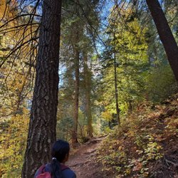
Marshall your energy, the gulch awaits! My dad and I decided to take on the Marshall Gulch and Aspen trail loop this Saturday and had a nice time exploring this area of the Mount Lemmon wilderness. Unlike much of the mountainside, this trail has a significant amount of forested area with ferns, aspen trees, and of course the fairly steeped sides ravine where the gulch stands, now dry in the hot Arizona summer temperatures. Also interesting is a significant wild fire burned a large portion of Mount Lemmon about five years ago. As a result, many charred trees still stand upright in the area towering above areas rich with plant growth due to the nutrient rich ash fall. The trail itself, combined with Aspen trail forms a loop that is almost exactly 4 miles long. I noticed that All Trails has it listed as 3.6 miles but was able to track our walk with my watch. The hike is what I would consider to be moderate. There are definitely portions with steeper ascent and also portions that can be a bit narrow. If you're a beginner hiker, it is doable but be prepared to take breaks and drink a lot of water. Regardless of your hiking skill, I would strongly recommend going counterclockwise as there is significant elevation change on the southern and eastern parts of the loop. This is much nicer to go down this section rather than up. Other notes - there are bathrooms at the trail head but no handwashing sinks so try to bring some hand sanitizer or wipes. There are also a few small parking areas near the trail head but these do fill up quickly and require a $8 daily fee, paid by an envelope dropbox honor system. Overall, great hike! read more


My favorite hiking trail. Recently took my baby sister up for a drive and 3 mile hike. She was surprised that you can find peace and joy in nature. Away from the buzzing distraction of technology (minus my camera lol). We were able to get a good workout in and enjoy the refuge from Tucson heat. She enjoyed herself but wants to try a new trail. I'll definitely be back. read more


10 years ago
Camping mt. Lemmon was a wonderful experience and very fun. It's always nice to get away from the city and the heat. We did Marshalls Gulch early in the am. The trail is an easy 4 mile hike, easy to low moderate. We did the hike with out little pug and he rocked it. The trail is well maintained, amazing views throughout the hike. It also has several streams and it smells forresty. We started Marshalls gulch and followed the Aspen trail head. It has great areas to stop and admire the views, eat an orange or trail mix and just forget about the world. We will definitely do this one again. Highly recommended. read more


9 years ago
More info about Marshall Gulch Trail
Sky Islands Traverse
Mount Lemmon, AZ 85619
Directions
Visit Website
http://www.fs.usda.gov
Hours
Payment methods
Outdoor Amenities


Marshall Gulch Trail - hiking - Updated June 2026
Best of Mount Lemmon
People found Marshall Gulch Trail by searching for…
Things to Do in Mount Lemmon, Arizona
Picnic Areas in Mount Lemmon, Arizona
Fishing Spots in Mount Lemmon, Arizona
Lakes & Ponds in Mount Lemmon, Arizona
Places to Take Pictures in Mount Lemmon, Arizona
Swimming Lakes in Mount Lemmon, Arizona
Hiking Trails in Mount Lemmon, Arizona
Easy Hikes in Mount Lemmon, Arizona
Dude Ranch in Mount Lemmon, Arizona
Sunset View in Mount Lemmon, Arizona
Secret Spots in Mount Lemmon, Arizona
Sunrise View in Mount Lemmon, Arizona
Scenic Overlook in Mount Lemmon, Arizona
Walking Trails in Mount Lemmon, Arizona
Horse Stables in Mount Lemmon, Arizona
Caves in Mount Lemmon, Arizona
Hiking With Kids in Mount Lemmon, Arizona
Free Parking in Mount Lemmon, Arizona
Beautiful Views in Mount Lemmon, Arizona
Tent Camping in Mount Lemmon, Arizona
Waterfall Hike in Mount Lemmon, Arizona
Horse Ranch in Mount Lemmon, Arizona
Browse Nearby
Browse Brands
Browse Articles
People who viewed Marshall Gulch Trail also viewed
Tumamoc Hill
154 reviews
Mount Lemmon
118 reviews
Pima Canyon Trail
12 reviews
Oracle State Park Center for Environmental Education
5 reviews
David Yetman Trail
10 reviews
Rillito River Park
38 reviews
Campus Farm
Saguaro National Park
287 reviews
Tortolita Mountain Park
2 reviews
Sweetwater Wetlands
25 reviews
Agua Caliente Trail
2 reviews