Mansfield Bridge Photos


More like Mansfield Bridge
Recommended Reviews - Mansfield Bridge
Start your review...

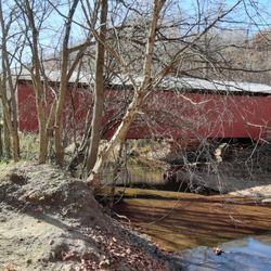
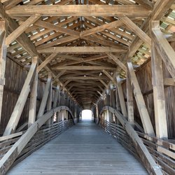
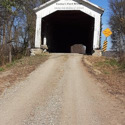
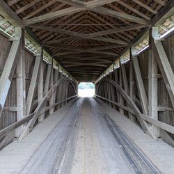
Built by Joseph J. Daniels in 1867 and still in use, this is the second longest surviving covered bridge in Parke County with a footprint of 279 feet (#5 on the Covered Bridge Map). The unusual Double Span Double Burr Arch Truss carries Mansfield Road across Big Raccoon Creek. There is a picnic table alongside the creek, but if you come during the festival, be prepared to pay for parking, and to cope with large crowds. We came a week after the festival closed, to find the site utterly deserted. If you are a photography buff, we strongly recommend visiting the bridges a week before or a week after the festival. Added to the National Register of Historic Places in 1978, this is one of nine covered bridges erected by Daniels in Parke County. read more


While driving along SR 59, about halfway between US 40 (Brazil) and US 36 (Bellmore), you may see signs for a historic town that has a couple covered bridges, a dam, and an old roller mill. Welcome to Mansfield! Most folks stop by during the fall festival season as part of the Parke County Covered Bridge tour. This is one of the stops for the Black Route. I stopped by in the non-peak season and was able to avoid the crowds and actually drive through the bridge. The bridge is well maintained and though I had to drive through at a walking pace, it is nice to know that the care for the place is good enough to still support a vehicle (it was refurbished in 1990.) Painted in the classic red and white of Parke County, the bridge was created in 1867 making it one of the oldest bridges in the state. The Burr Arch-truss structure has windows that allow for great views of the upstream dam and roller mill. The bridge spans 125 feet and is 247 feet in total length which makes this one of the larger bridges in the state (3rd in the county). If you find yourself in the area, take a short drive and visit this site that springs to life in the autumn. Review #2739 read more


Covered Bridge season! All the good eats and more. Front half is flea market, vendor services. Back half is more traditional home made, crafty stuffs, but less of it than Bridgeton. Best food (imo) bc it has a larger selection and I go to the same spots each year! read more


We have arrived at the Mansfield Covered Bridge Festival. Woohoo!! Everyone is so excited! It is advertised as the largest festival in Indiana and if you haven't been I can tell you that it's huge! Some people go to Rockville, but it's a drop in the bucket compared to Mansfield. We arrived at 9:15 am and left when it closed at 6:00 pm. The thing is we didn't get to see several of the booths. You probably know what I'm talking about when I mention those shopping carts with a handle that you pull with you; we had two of those plus two large bags, one on back of each of Tony and I's Powerchair. My point is we had to go to our vehicles twice to empty everything and start again.It's nearly impossible to tell you what's there. It's new stuff and old stuff, arts and crafts, helicopter rides, so many food choices it would take me a whole day to think of them. Glassware, jewelry, pottery, dog and cat toys and treats. Clothes for men, for women, for teens and for babies. Trees and flowers. Guitars and amplifiers. Drinks of all kinds. The list goes on and on. Wednesday is least crowded day. Weekends are the most crowded. Go and have a blast! read more


More info about Mansfield Bridge


Mansfield Bridge - landmarks - Updated May 2026
Best of Carbon
People found Mansfield Bridge by searching for…
Trending Searches in Carbon, IN
Browse Articles
Browse Nearby
Browse Brands
Related Searches in Carbon, IN
Beautiful Flower Fields in Carbon, Indiana
Best Places for Stunning Views in Carbon, Indiana
Discover Charming Historic Homes in Carbon, Indiana
Discover Fun Things to Do Alone in Carbon, Indiana
Discover Historic Sites and Places in Carbon, Indiana
Discover Popular Landmarks in Carbon, Indiana
Discover Popular Photo Spots in Carbon, Indiana
Discover Romantic Views in Carbon, Indiana
Discover Stunning Skyline View Spots in Carbon, Indiana
Discover Top Nature Parks to Visit in Carbon, Indiana
Discover the Best Caves to Explore in Carbon, Indiana
Discover the Best Night Hike Trails in Carbon, Indiana
Enjoy Arts & Entertainment in Carbon, Indiana
Enjoy Hiking Adventures in Carbon, Indiana
Enjoy the Best Night View Spots in Carbon, Indiana
Enjoy the Best Walking Trails in Carbon, Indiana
Experience Stunning Sunset Views in Carbon, Indiana
Explore Beautiful Castles and Landmarks in Carbon, Indiana
Explore Beautiful Parks and Green Spaces in Carbon, Indiana
Explore Easy Hikes Perfect for All in Carbon, Indiana
Explore Popular Scenic Overlook Points in Carbon, Indiana
Explore Popular Scenic Views Near Carbon, Indiana
Explore Popular View Points Around Carbon, Indiana
Explore Secret Spots Worth Visiting in Carbon, Indiana
Explore Sunday Fun Things to Do in Carbon, Indiana
Explore Top Things to Do at Night in Carbon, Indiana
Explore the Best Trail Options in Carbon, Indiana
Explore the Rich History in Carbon, Indiana
Find Beautiful Views in Carbon, Indiana
Find Fun Things to Do at Night With Kids in Carbon, Indiana
Find Popular Running Stairs Locations in Carbon, Indiana
Find Top Dog Friendly Parks to Visit in Carbon, Indiana
Find Top-Rated Waterfalls in Carbon, Indiana Now
Find the Best Bridge Spots in Carbon, Indiana
Find the Best Playgrounds to Visit in Carbon, Indiana
Fun Indoor Activities to Try in Carbon, Indiana
Get Your City Pass for Attractions in Carbon, Indiana
Hiking Trails With Waterfalls in Carbon, Indiana
Popular Picnic Spots to Visit in Carbon, Indiana
Popular Places to Take Pictures in Carbon, Indiana
Popular Places to Walk Around in Carbon, Indiana
Popular Things to See in Carbon, Indiana
Stair Climbing Activities and Gyms in Carbon, Indiana
Top Fun Things to Do at Night in Carbon, Indiana
Top Hiking Trails to Explore in Carbon, Indiana
Top Places to Visit in Carbon, Indiana for Sightseeing
Top Things to Do With Teenagers in Carbon, Indiana
Tour Famous Lighthouses Located in Carbon, Indiana
People who viewed Mansfield Bridge also viewed
Neet Covered Bridge
4 reviews
Rush Creek Covered Bridge
2 reviews
Catlin Covered Bridge
3 reviews
Crooks Covered Bridge
5 reviews
Beeson Covered Bridge
5 reviews
Wilkins Mill Covered Bridge
3 reviews
City of Terre Haute
3 reviews
Billie Creek Covered Bridge
3 reviews
Cox Ford Covered Bridge
3 reviews
Ryves Hall Youth Center
3 reviews