Lower Guadalupe River Trail Photos


You might also consider
More like Lower Guadalupe River Trail
Recommended Reviews - Lower Guadalupe River Trail
Start your review...

Reviews With Photos

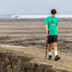
Where fresh river water meets the Bay! The lower part of Guadeloupe River Trail subtlety vibrates with a different shade of green life. Here different plants grow that are irrigated by both the waters of the Bay and river water. When the tides comes in you can see this part of the rivers change course. All the water flows upriver. It is a strange sight to see, even though the tide changing is the least strange thing to witness. I suppose growing up near San Jose, I didn't live day-to-day experiencing the changes of the tides. So, what might be somewhat mundane for the fisherman is magical for me. If you stand on Gold Street bridge in Alviso you too can see some of this beauty.

I applaud any effort to put greenways in the heart of cities but I was not a big fan of this trail, from a running perspective. I think maybe for biking or something it might be a little bit better. Went for a run on a weekday morning about 7:00 am. Sun was up and I got on the trail at Park and was running north on the east side of the river. It is not particularly scenic, but that isnt a big deal to me. Running north, I only saw one other runner. As we waited to cross the street at Julian, I asked him how safe the trail was because reading reviews it seemed like there were some sketchy areas. He was from out of town too so we just ran on. Right after that, the path narrows and there is a long underpass that goes under train tracks. When we approached that, there were three guys standing there just blocking the path. We both took a look at them and made a U Turn. It just didn't feel safe. Running past other underpasses where the path was wider and it was more open, there were lots of people living under them. But that one, I did not want to chance, especially being outnumbered. The areas where the people live do not smell great and it is an unfortunate situation all around. I saw people riding bikes on the west side and maybe that is better. If I was on a bike going fast, I would be more comfortable, but being out there with no defense except my running shorts and my razor sharp wit, I just didn't feel safe. I would be very uncomfortable if I were a woman running alone, to be honest. Where the trail was above ground or wide open by the river , it was fine. The trail was actually pretty clean otherwise, just overgrown in places.

There are parts of the trail that are nicer, but for the most part, there is a lot of overgrown grass and nothing too scenic. The place is overrun by the homeless and drug users - every 50 feet or so we walked, we would see a tent set up off path in between the bushes. Personally, I wouldn't come here alone. They also have a rose garden near this trail that's rather small but pretty nice. There are a couple of parking lots around different parts of the lower and upper trails which is pretty convenient.

The Lower Guadalupe River Trail (LGR) is the 2nd longest concurrent trail in Santa Clara County; with the Los Gatos Creek Trail being the longest (9-miles vs 9.7-miles). However, once it's linked up with the Upper Guadalupe River Trail -sometime in the future- it will be almost ±15-miles long. The LGR is nicknamed "San Jose to the Bay" as it runs from the southern edge of the San Francisco Bay in Alviso to Downtown San José. Here are some of the high (and low) lights of the LGR: -Mostly paved AC Trail which is a must for those of us that push a jogging stroller, or don't like running/walking on dirt. -Most of the roadway crossings are under-crossings except for St. John St. and Julian Ave. -At the right times of year, the greenery can be beautiful and awe-inspiring-- just try not to pay too much attention to the debris in the river. -A lot of San José's major facilities and tourist destinations are accessible via the LGR. Here's a (not-so) short list: SJC; SAP Center (aka The Tank); Diridon Station; Heritage Rose Garden; Historic Town of Alviso; Children's Discovery Museum; Tech Museum of Innovation; San José Convention Center; various parks (Columbus, Arena Green, Guadalupe River Gardens, etc); and even Levi's Stadium will be accessible via the LGR. -Not the most nature-centric trail as you're almost constantly surrounded by vehicles and freeways--you never get that lost in nature Zen that you may be seeking. -Huge Local Outdoor Enthusiast (LOE) population that's spread throughout the entire length of trail, but is heaviest in the Downtown area between Columbus Park and the Guadalupe River Gardens. I hate bashing the LOE but I've had various run-ins with them on this section of trail and I've even had to call SJPD a few times because one maniac was brandishing a firearm. The LGR is a classic example of how its greatest strength (accessibility, length, and proximity to key facilities) is also its greatest weakness. It's not a bad trail on its surface, but I can't really recommend coming on this trail alone, late at night or early in the morning; I know for a fact that there's a boatload of shenanigans afoot at any given time. But if you feel adventurous then go right ahead--just don't say I didn't warn you.

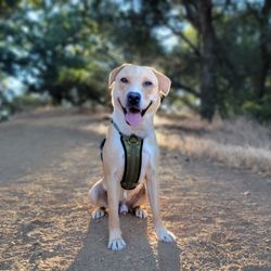
I love living close to this trail. It's very scenic and a great place to go for a run, walk your dog, or take a stroll before sunset. It does get crowded sometimes and if your walking, you may find yourself dodging bikes here and there. I have never felt unsafe but I would recommend giving yourself ample time to walk back to your car or home before the sun sets. I often get stopped by walkers asking to pet my mini goldendoodle, so he loves the attention he gets as well. Its very beautiful before sunset so I recommend bringing your camera for some golden hour shots!

I believe the entire trail is a little over 7 miles, 14 roundtrip but unfortunately I was only able to do a little over 8 miles because my monster was getting antsy in the stroller. I decided walk the trail on Sunday for various reasons: a) groceries completed Saturday, b) laundry completed Saturday, c) free parking on Sundays, and d) decided to rest my body instead of going to the gym. I parked right across from the HP Pavilion - Home of the Sharks! Both of us seemed to enjoy the peaceful and serene surrounding. Cristal C. is right about the even paved roads. This trail is very stroller-friendly! I saw a guy jogging w/ his stroller and it made me envious because I can't do that w/ the stroller that I have currently. That just means that I need to check www.craigslist.org for used strollers geared for jogging. I need to find a bike trailer, too because once the sun is shining its rays down on us, I would like to be able to bike around to a) burn calories, b) build lower body strength, c) save on gas, and d) eleminate the hassle of finding parking (not to mention the majority of drivers out there are idiots). Not a scenic trail by any means. I saw a lot of litter *sad* which makes me want to return to this trail to organize a "clean up day" because I like to do stuff like this. This is our trail and if we don't take care of it, who will? I do understand there are a lot of homeless folks that reside on this very trail... it was even on the news this morning on KTVU. I just feel that we need to take better care of our environment and our people... some people are homeless due to the choices they have made (drugs, alcohol, etc.) but there are a few out there that are homeless simply because they got laid-off or because they can't make ends meet. I was hanging by a thread for a long ass time so I empathize greatly. As I walked, my monster kept me at peace, I started to recall good memories that happened not too long ago. Like when Kevin drove from SoCal to see me in June 2012. Our first meal together was at Smoke Eaters; I don't know how much exposure he has w/ kids but he gave my monster a piece of fry and it nearly choked the kid [haha]. On a separate weekend, we had a long albeit fun day in Monterey, we went to Safeway to get jambalaya and jalapeno bread; that was our late night dinner whilst sitting on my futon watching American Dad via Netflix. We had our first date (no kids) the second weekend we spent together... we watched Ted at the theater located at Santana Row. He asked me to the movies before ever meeting me. Having a long distance relationship calls for a lot of arguments, compromises, and the anticipation of when we'll be able to see each other next. I miss him dearly. I was also thinking about weddings. No, not my wedding but my best friend's wedding. I'm one of her bridesmaids so I need to start looking for a dress. I want a corset-style dress. I want the dress to be a flattering dark fall color (her colors are orange, brown, olive green, dark red), short in length (above the knees), and long-sleeves... hell, I might need to have it made especially for Tram! I don't know why but I'm excited and that excitement just started. I blame Cuc Crystal N. because of her review and awesome pictures of Vera Wang, San Francisco. I am starting the complete P90X program today so that my upper body (back, deltoids, biceps, and triceps) will be toned for the wedding. My legs are the only thing about me that I'm actually happy w/ but thankfully the program is a complete full body home bootcamp. I do have Insanity, too but I'll save the cardio for the gym and doing trails such as this. I'm just a bridesmaid and I'm going crazy already - hair, makeup, shoes, body fat %, dress must flatter body and look fabulous, how to smile [haha], pedicure, etc., etc. I can't imagine how insane I'll be when it's my own wedding. I'm typing freely and that's what being on the trail made me feel. I was thinking freely and smiled a lot to myself from the memories and future endeavours that I will embark on. Here are the things on my to-do list: - start volunteer journey at Heartland Hospice - use all my baking ingredients and bake for the 2 fire stations nearby - find tickets for San Francisco Giants' April 6 game - find tickets for San Jose Shark' March 28 game - look up airfares - start shopping for Kevin's birthday (I won't be publicizing my check-ins!!) What a great start to my week. Happy Monday!!!

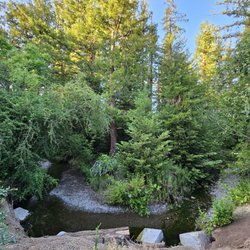
Finally reached the end of the Lower Guadalupe River Trail. I have done many portions of this long trail, but just coincidentally went for a picnic at the Don Edwards Educational center (which is mostly a set of picnic tables under a wood roof and some posters explaining the history of Alviso and the importance of the water in this area) and found out my lost and last portion of trail. I met a lovely old Mexican man who told my colleague and I stories of the area from someone like him who spends most of his day seating by the sign seeing life pass and many employees from nearby companies walking and exercising during their lunch breaks. You cross the sign and you are already in Alviso, still San Jose but like a quaint semi ghost interesting town with things to discover (and construction going on, so won't last like this forever). This trail portion is well taken care of, very clean (they are clean public restrooms nearby) and extremely pleasant to walk without complications. You will even see water! (not always possible) and animal life, especially families of goose enjoying their lives. Very relaxing, quiet and refreshing.

First of all, I don't know what some people are complaining about. I read some of the reviews and we're just lucky we have a trail to run, bike, and walk our dogs. It has been a blessing to have this trail to train for my marathon. There are many ways to access this trail. This trail is a little over 20 miles, so it's perfect! On my longer runs, I would run down past 237 to Alviso and down to San Jose International Airport. If you continue all the way down it will lead you to the Rose Garden in San Jose. I never had any problems running on this trail. There are rocky, dirt, and paved paths along the way. You also run under levees to avoid the streets. If the levees are flooded then you just run across the street to get to the other side of the trail. I've been seeing the same people using this trail, so it's always nice to see familiar faces. Of course, don't use this trail or any other trails when it gets dark. I had to knock down a star due to the litter along the levees. People PLEASE don't litter! Also, this is a LEASHED dog trail. I almost stepped on an unleashed little chihuahua once while running. There's also a man with two big rottweilers that does the same thing. Hopefully, I don't get attacked one of these days by them :ox

1 year ago
THIS TRAIL WAS NOT IT Having just moved from Portland to San Jose, I was eager to find my new go-to biking route. I spotted this trail along the Guadalupe River on Google Maps and thought it had potential, so I set out on a Sunday morning to test it with a ~20-mile round trip from DTSJ to Alviso and back. Let's just say, I PR'd because I've never biked so fast in my life. LMAO! DON'T RECOMMEND Starting from Arena Green Park on the east side of the trail, my initial excitement quickly dwindled. The beginning of the trail was NOT ideal. There were numerous homeless encampments, piles of trash, and stretches where I honestly felt unsafe - even in broad daylight. HALF OK, HALF BAD Some sections ran alongside the highway, with no one else in sight for miles. In other areas, I had to bike under long, dark overpasses. It wasn't until I passed the airport and the tech company buildings near Montague Expressway that I finally felt a bit more secure, especially seeing other people walking and biking. Unfortunately, that feeling was short-lived. Past Southbay Freeway and into Alviso, the trail became increasingly barren and far less scenic. TLDR While I did like that this trail goes on for miles, I wouldn't recommend tackling it alone, especially in certain areas. Some parts are decent, but this overall first experience left me looking for another go-to biking route. read more


1 year ago
Ok, the *SOUTH* part of the trail is the *UPPER* Guadalupe River Trail, and the *NORTH* part of the trail (Almaden Park to the 85) is the *LOWER* Guadalupe River Trail. Watch out for demogorgons because we're in the Upside Down. If your head is not bleeding yet, Lower has a North and South. The North section goes from Gold Street in Alviso, past the 237, light rail, and a distant Levis Stadium 1.65 miles to Montague, where parking is such sweet sorrow. The South goes from Montague, past the 101 and airport, into Guadalupe River Park & Gardens, to the south of downtown with a dead-end at West Virginia, emphasis on the Dead. That's where we started, an entrance just a block from Prevost and West Virginia, site of San Jose's 17th homicide of 2021. I know this because the news stories popped up as I searched for a good parking spot. This is the only bike path sponsored by KRON. So, if you find chalk on your tires upon your return, it's probably not from a diligent meter maid but from parking on the outline of a body. Anyway, the entrance is marked with a huge heap of overflowing trash cans and graffiti. Running parallel to the 87, we passed a few shirtless guys with more tattoos than teeth and "campsites" before reaching the Children's Discovery Museum downtown. There, we dodged a shirtless guy holding a pipe, a shopping cart or two, low-hanging maintenance-free trees, and a motionless body in a mummy sleeping bag (Barb??) that made this feel like the hood version of Paperboy. Paperboyz in the Hood. I ignored my wife's requests to turn back (which began way back at the entrance with used Huggies mile markers) until we had to pass two sketchers and their pit bull who probably wanted me to answer riddles three, so we gave up and headed back while we still could. Instead of giving up, we packed the bikes and started at the north end in Alviso. We parked at the Alviso Education Center, even though two of the ten parking spaces had remnants of window glass. (I recommend parking a few blocks north at Alviso County Marina Park). We rode five miles south to the airport and this paved, level, straight, and clean bike path was a much different scenario. Couples, fitness enthusiasts, cyclists, and some families were walking and riding in peace, with condos, trailer parks, a driving range, a park, hotels, corporate buildings, and Lupe the Mammoth (public art 441 W Trimble Rd) on one side, and the Guadelupe River on the other. The River is a fine view, though stagnant in some areas. Aside from the trash-filled field of Alviso Towing, there were no homeless, no graffiti, and no obstacles, other than some daring squirrels playing Frogger. Though the north side of the trail is fine for locals, if I am going to pack up the bikes, we much prefer Coyote Creek trail. read more

Where fresh river water meets the Bay! The lower part of Guadeloupe River Trail subtlety vibrates with a different shade of green life. Here different plants grow that are irrigated by both the waters of the Bay and river water. When the tides comes in you can see this part of the rivers change course. All the water flows upriver. It is a strange sight to see, even though the tide changing is the least strange thing to witness. I suppose growing up near San Jose, I didn't live day-to-day experiencing the changes of the tides. So, what might be somewhat mundane for the fisherman is magical for me. If you stand on Gold Street bridge in Alviso you too can see some of this beauty. read more

I applaud any effort to put greenways in the heart of cities but I was not a big fan of this trail, from a running perspective. I think maybe for biking or something it might be a little bit better. Went for a run on a weekday morning about 7:00 am. Sun was up and I got on the trail at Park and was running north on the east side of the river. It is not particularly scenic, but that isnt a big deal to me. Running north, I only saw one other runner. As we waited to cross the street at Julian, I asked him how safe the trail was because reading reviews it seemed like there were some sketchy areas. He was from out of town too so we just ran on. Right after that, the path narrows and there is a long underpass that goes under train tracks. When we approached that, there were three guys standing there just blocking the path. We both took a look at them and made a U Turn. It just didn't feel safe. Running past other underpasses where the path was wider and it was more open, there were lots of people living under them. But that one, I did not want to chance, especially being outnumbered. The areas where the people live do not smell great and it is an unfortunate situation all around. I saw people riding bikes on the west side and maybe that is better. If I was on a bike going fast, I would be more comfortable, but being out there with no defense except my running shorts and my razor sharp wit, I just didn't feel safe. I would be very uncomfortable if I were a woman running alone, to be honest. Where the trail was above ground or wide open by the river , it was fine. The trail was actually pretty clean otherwise, just overgrown in places. read more


7 years ago
There are parts of the trail that are nicer, but for the most part, there is a lot of overgrown grass and nothing too scenic. The place is overrun by the homeless and drug users - every 50 feet or so we walked, we would see a tent set up off path in between the bushes. Personally, I wouldn't come here alone. They also have a rose garden near this trail that's rather small but pretty nice. There are a couple of parking lots around different parts of the lower and upper trails which is pretty convenient. read more


The Lower Guadalupe River Trail (LGR) is the 2nd longest concurrent trail in Santa Clara County; with the Los Gatos Creek Trail being the longest (9-miles vs 9.7-miles). However, once it's linked up with the Upper Guadalupe River Trail -sometime in the future- it will be almost ±15-miles long. The LGR is nicknamed "San Jose to the Bay" as it runs from the southern edge of the San Francisco Bay in Alviso to Downtown San José. Here are some of the high (and low) lights of the LGR: -Mostly paved AC Trail which is a must for those of us that push a jogging stroller, or don't like running/walking on dirt. -Most of the roadway crossings are under-crossings except for St. John St. and Julian Ave. -At the right times of year, the greenery can be beautiful and awe-inspiring-- just try not to pay too much attention to the debris in the river. -A lot of San José's major facilities and tourist destinations are accessible via the LGR. Here's a (not-so) short list: SJC; SAP Center (aka The Tank); Diridon Station; Heritage Rose Garden; Historic Town of Alviso; Children's Discovery Museum; Tech Museum of Innovation; San José Convention Center; various parks (Columbus, Arena Green, Guadalupe River Gardens, etc); and even Levi's Stadium will be accessible via the LGR. -Not the most nature-centric trail as you're almost constantly surrounded by vehicles and freeways--you never get that lost in nature Zen that you may be seeking. -Huge Local Outdoor Enthusiast (LOE) population that's spread throughout the entire length of trail, but is heaviest in the Downtown area between Columbus Park and the Guadalupe River Gardens. I hate bashing the LOE but I've had various run-ins with them on this section of trail and I've even had to call SJPD a few times because one maniac was brandishing a firearm. The LGR is a classic example of how its greatest strength (accessibility, length, and proximity to key facilities) is also its greatest weakness. It's not a bad trail on its surface, but I can't really recommend coming on this trail alone, late at night or early in the morning; I know for a fact that there's a boatload of shenanigans afoot at any given time. But if you feel adventurous then go right ahead--just don't say I didn't warn you. read more


6 years ago
I love living close to this trail. It's very scenic and a great place to go for a run, walk your dog, or take a stroll before sunset. It does get crowded sometimes and if your walking, you may find yourself dodging bikes here and there. I have never felt unsafe but I would recommend giving yourself ample time to walk back to your car or home before the sun sets. I often get stopped by walkers asking to pet my mini goldendoodle, so he loves the attention he gets as well. Its very beautiful before sunset so I recommend bringing your camera for some golden hour shots! read more


7 years ago
I believe the entire trail is a little over 7 miles, 14 roundtrip but unfortunately I was only able to do a little over 8 miles because my monster was getting antsy in the stroller. I decided walk the trail on Sunday for various reasons: a) groceries completed Saturday, b) laundry completed Saturday, c) free parking on Sundays, and d) decided to rest my body instead of going to the gym. I parked right across from the HP Pavilion - Home of the Sharks! Both of us seemed to enjoy the peaceful and serene surrounding. Cristal C. is right about the even paved roads. This trail is very stroller-friendly! I saw a guy jogging w/ his stroller and it made me envious because I can't do that w/ the stroller that I have currently. That just means that I need to check www.craigslist.org for used strollers geared for jogging. I need to find a bike trailer, too because once the sun is shining its rays down on us, I would like to be able to bike around to a) burn calories, b) build lower body strength, c) save on gas, and d) eleminate the hassle of finding parking (not to mention the majority of drivers out there are idiots). Not a scenic trail by any means. I saw a lot of litter *sad* which makes me want to return to this trail to organize a "clean up day" because I like to do stuff like this. This is our trail and if we don't take care of it, who will? I do understand there are a lot of homeless folks that reside on this very trail... it was even on the news this morning on KTVU. I just feel that we need to take better care of our environment and our people... some people are homeless due to the choices they have made (drugs, alcohol, etc.) but there are a few out there that are homeless simply because they got laid-off or because they can't make ends meet. I was hanging by a thread for a long ass time so I empathize greatly. As I walked, my monster kept me at peace, I started to recall good memories that happened not too long ago. Like when Kevin drove from SoCal to see me in June 2012. Our first meal together was at Smoke Eaters; I don't know how much exposure he has w/ kids but he gave my monster a piece of fry and it nearly choked the kid [haha]. On a separate weekend, we had a long albeit fun day in Monterey, we went to Safeway to get jambalaya and jalapeno bread; that was our late night dinner whilst sitting on my futon watching American Dad via Netflix. We had our first date (no kids) the second weekend we spent together... we watched Ted at the theater located at Santana Row. He asked me to the movies before ever meeting me. Having a long distance relationship calls for a lot of arguments, compromises, and the anticipation of when we'll be able to see each other next. I miss him dearly. I was also thinking about weddings. No, not my wedding but my best friend's wedding. I'm one of her bridesmaids so I need to start looking for a dress. I want a corset-style dress. I want the dress to be a flattering dark fall color (her colors are orange, brown, olive green, dark red), short in length (above the knees), and long-sleeves... hell, I might need to have it made especially for Tram! I don't know why but I'm excited and that excitement just started. I blame Cuc Crystal N. because of her review and awesome pictures of Vera Wang, San Francisco. I am starting the complete P90X program today so that my upper body (back, deltoids, biceps, and triceps) will be toned for the wedding. My legs are the only thing about me that I'm actually happy w/ but thankfully the program is a complete full body home bootcamp. I do have Insanity, too but I'll save the cardio for the gym and doing trails such as this. I'm just a bridesmaid and I'm going crazy already - hair, makeup, shoes, body fat %, dress must flatter body and look fabulous, how to smile [haha], pedicure, etc., etc. I can't imagine how insane I'll be when it's my own wedding. I'm typing freely and that's what being on the trail made me feel. I was thinking freely and smiled a lot to myself from the memories and future endeavours that I will embark on. Here are the things on my to-do list: - start volunteer journey at Heartland Hospice - use all my baking ingredients and bake for the 2 fire stations nearby - find tickets for San Francisco Giants' April 6 game - find tickets for San Jose Shark' March 28 game - look up airfares - start shopping for Kevin's birthday (I won't be publicizing my check-ins!!) What a great start to my week. Happy Monday!!! read more


Finally reached the end of the Lower Guadalupe River Trail. I have done many portions of this long trail, but just coincidentally went for a picnic at the Don Edwards Educational center (which is mostly a set of picnic tables under a wood roof and some posters explaining the history of Alviso and the importance of the water in this area) and found out my lost and last portion of trail. I met a lovely old Mexican man who told my colleague and I stories of the area from someone like him who spends most of his day seating by the sign seeing life pass and many employees from nearby companies walking and exercising during their lunch breaks. You cross the sign and you are already in Alviso, still San Jose but like a quaint semi ghost interesting town with things to discover (and construction going on, so won't last like this forever). This trail portion is well taken care of, very clean (they are clean public restrooms nearby) and extremely pleasant to walk without complications. You will even see water! (not always possible) and animal life, especially families of goose enjoying their lives. Very relaxing, quiet and refreshing. read more


15 years ago
First of all, I don't know what some people are complaining about. I read some of the reviews and we're just lucky we have a trail to run, bike, and walk our dogs. It has been a blessing to have this trail to train for my marathon. There are many ways to access this trail. This trail is a little over 20 miles, so it's perfect! On my longer runs, I would run down past 237 to Alviso and down to San Jose International Airport. If you continue all the way down it will lead you to the Rose Garden in San Jose. I never had any problems running on this trail. There are rocky, dirt, and paved paths along the way. You also run under levees to avoid the streets. If the levees are flooded then you just run across the street to get to the other side of the trail. I've been seeing the same people using this trail, so it's always nice to see familiar faces. Of course, don't use this trail or any other trails when it gets dark. I had to knock down a star due to the litter along the levees. People PLEASE don't litter! Also, this is a LEASHED dog trail. I almost stepped on an unleashed little chihuahua once while running. There's also a man with two big rottweilers that does the same thing. Hopefully, I don't get attacked one of these days by them :ox read more


13 years ago
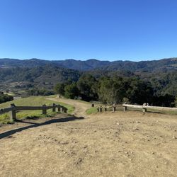
Just decided to try this trail out on July 4th after reading other reviews the night before. I guess I picked up on all the good things people said about this trail. Really even pavement, wide pathways, a lot of directional signs and mile markers, nice views (especially of the new 9ers stadium), nice people, restrooms and cool rest benches, off ramps to main streets and a really cool end point rest stop at Gold Street with people you can talk to. Because of its gradual elevation decrease from San Jose to Alviso and then increase from Alviso to San Jose, it really makes it a great trail to bike. I bike it from East San Jose then get on at Julian so I have to climb 2 overpasses before I start the trial. Coming back home really pushes my endurance and I love it! Definitely my fav trail so far. Don't plan to doing a night ride, but early weekend mornings are great. Good riding ya'll! read more

5 years ago
17 years ago
11 years ago
I enjoy coming to this section of the Guadalupe River Trail for a stroll or jog because of its convenient location. It is close to the River Oaks light rail station and parking is easy if you drive. The trail hugs the creek which provides a change of scenery along the way. If you head north starting from Montague, it will lead you all the way to Alviso and Levi Stadium is in sight. A round trip makes a decent 6-mile run. If you go south, you will come across the Shark Tank and downtown San Jose. In recent years, they have paved one side of this part of the trail so it is smooth for biking. Personally, I hope they keep the other side untouched for those who prefer gravel. There are also many walkers from the residential area nearby. We just need to be respectful and share this pleasant trail. read more

9 years ago
11 years ago
12 years ago
16 years ago
17 years ago
13 years ago
7 years ago
6 years ago
The new Guadalupe River Trail or should I say the new surface and the work they've done to improve this trail had been magnificent. I take the trail from W. Tasman Drive for run going towards the Mineta SJ International Airport which is approximately 5 miles. The trail have a new asphalt surface that is smooth for bicycle riding. I like the quarter mile marker they put in along the trail. I gave it 5 star good. read more

13 years ago
Watch out for the underpass at Tasman it'll mess up your tires if you're going too fast. Also, the trail north of the airport is all clean and well travelled. The trail is well maintained from the airport to Gold Street save for the aforementioned underpass 4.5 stars read more

14 years ago
13 years ago
Page 1 of 2
More info about Lower Guadalupe River Trail
438 Coleman Ave
San Jose, CA 95109
Downtown
Directions
(408) 298-3500
Call Now
Hours
Indoor Amenities
Outdoor Amenities
Ask the Community - Lower Guadalupe River Trail
Review Highlights - Lower Guadalupe River Trail
You might also consider


Why does Yelp recommend reviews?
Lower Guadalupe River Trail - hiking - Updated May 2026
Best of San Jose
People found Lower Guadalupe River Trail by searching for…
Beaches in San Jose, California
Fishing Spots in San Jose, California
Great View Points for Sunset in San Jose, California
Fall Foliage in San Jose, California
Scenic Drives in San Jose, California
Scenic Night View in San Jose, California
Dog Friendly Beaches in San Jose, California
Hiking Trails in San Jose, California
Fishing in San Jose, California
Dirt Bike Riding in San Jose, California
Dog Friendly Parks in San Jose, California
Running Trails in San Jose, California
Scenic Spots in San Jose, California
Camping Sites in San Jose, California
Creeks in San Jose, California
Fishing Lake in San Jose, California
Off Road Trails in San Jose, California
Night Hiking in San Jose, California
Urban Exploration in San Jose, California
Fishing Ponds in San Jose, California
Easy Hikes in San Jose, California
Walking Trails in San Jose, California
Trending Searches in San Jose, CA
Boat Rental near Lower Guadalupe River Trail
Botanical Gardens near Lower Guadalupe River Trail
Bounce House Rentals near Lower Guadalupe River Trail
Campgrounds near Lower Guadalupe River Trail
Cherry Picking near Lower Guadalupe River Trail
Cliff Jumping near Lower Guadalupe River Trail
Dog Friendly Things To Do near Lower Guadalupe River Trail
Flower Fields near Lower Guadalupe River Trail
Flower Shop near Lower Guadalupe River Trail
Garage Sales near Lower Guadalupe River Trail
Hair near Lower Guadalupe River Trail
Lakes & Ponds near Lower Guadalupe River Trail
Nurseries & Gardening near Lower Guadalupe River Trail
Outdoor Activities near Lower Guadalupe River Trail
Outdoor Furniture Stores near Lower Guadalupe River Trail
Parks near Lower Guadalupe River Trail
Party Equipment Rentals near Lower Guadalupe River Trail
Pedicure near Lower Guadalupe River Trail
Pick Your Own Farms near Lower Guadalupe River Trail
Picnic Areas near Lower Guadalupe River Trail
Places To Take Pictures near Lower Guadalupe River Trail
Running Trails near Lower Guadalupe River Trail
Scenic Drive near Lower Guadalupe River Trail
Secret Spots near Lower Guadalupe River Trail
Strawberry Picking near Lower Guadalupe River Trail
Sunrise View near Lower Guadalupe River Trail
Swimming Holes near Lower Guadalupe River Trail
Table And Chair Rentals near Lower Guadalupe River Trail
Browse Articles
Browse Nearby
BEST of San Jose, California Coffee near Lower Guadalupe River Trail
BEST of San Jose, California Things to Do near Lower Guadalupe River Trail
BEST of San Jose, California Restaurants near Lower Guadalupe River Trail
BEST of San Jose, California Breakfast near Lower Guadalupe River Trail
BEST of San Jose, California Walking Trails near Lower Guadalupe River Trail
BEST of San Jose, California Parks near Lower Guadalupe River Trail
BEST of San Jose, California Caves near Lower Guadalupe River Trail
BEST of San Jose, California Campgrounds near Lower Guadalupe River Trail
BEST of San Jose, California Sightseeing near Lower Guadalupe River Trail
Browse Brands
Related Searches in San Jose, CA
Affordable Kayak Rental Services in San Jose, California
Best Fishing Locations and Guides in San Jose, California
Best Nature Trails for Hiking in San Jose, California
Best Places for Horseback Riding in San Jose, California
Check Out Off Road Trails in San Jose, California
Discover Dog Friendly Trails to Explore in San Jose, California
Discover Kid Friendly Hiking Trails in San Jose, California
Discover Scenic Hiking Trails in San Jose, California
Discover Scenic Mountain Bike Trails Near San Jose, California
Discover Scenic Waterfall Spots in San Jose, California
Discover Walking Parks in San Jose, California Near You
Discover a Hiking Trail in San Jose, California
Discover the Best Night Hike Trails in San Jose, California
Dog-Friendly Hikes With Dogs in San Jose, California
Enjoy Camping Adventures Around San Jose, California
Enjoy Exciting Mountain Biking Adventures in San Jose, California
Enjoy Kayaking Adventures in San Jose, California
Enjoy Tent Camping Spots Around San Jose, California
Enjoy a Beautiful Waterfall Hike in San Jose, California
Enjoy a Peaceful Nature Walk in San Jose, California
Enjoy the Best Walking Path in San Jose, California
Enjoy the Best Walking Trails in San Jose, California
Exciting Cliff Jumping Spots in San Jose, California
Experience Thrilling White Water Rafting in San Jose, California
Explore Beautiful Parks and Green Spaces in San Jose, California
Explore Easy Hikes Perfect for All in San Jose, California
Explore Fun Activities to Do in San Jose, California
Explore Popular Campgrounds Near San Jose, California
Explore the Best Beach Spots in San Jose, California
Explore the Best Boating Spots in San Jose, California
Explore the Best Trail Options in San Jose, California
Family Friendly Hiking With Kids in San Jose, California
Find Popular Ziplining Spots Around San Jose, California
Find the Best Parks for Picnics in San Jose, California
Find the Best Scenic View Locations in San Jose, California
Great Places to Walk in San Jose, California
Hike the Popular Waterfall Trail in San Jose, California
Hiking Trails With Waterfalls in San Jose, California
Off Leash Dog Hiking Trails in San Jose, California
Plan a Scenic Drive Route Near San Jose, California
Popular Outdoor Activities to Try in San Jose, California
Popular Picnic Spots to Visit in San Jose, California
Safe River Swimming Areas in San Jose, California
Safe and Fun Parks for Kids in San Jose, California
Top Climbing Spots and Gyms in San Jose, California
Top Paddleboarding Activities in San Jose, California
Top Running Trails to Explore in San Jose, California
Top Swimming Spots and Pools in San Jose, California
People who viewed Lower Guadalupe River Trail also viewed
Montgomery Hill Park
37 reviews
Evergreen
Mount Umunhum
33 reviews
Los Alamitos Creek Trail
44 reviews
San Tomas Aquino Creek Trail
61 reviews
Alum Rock Park - Lariat Trail
1 review
Bear Creek Redwoods Preserve
32 reviews
Farnsworth Regional Trail - Access
2 reviews
Evergreen
Lexington Reservoir County Park
63 reviews
St Joseph's Hill Open Space Preserve
60 reviews
Hike the Mallard Slough Trail - Alviso
5 reviews