Liberty Lake Loop Trail Photos


More like Liberty Lake Loop Trail
Recommended Reviews - Liberty Lake Loop Trail
Start your review...

8 years ago
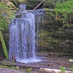
We took this hike a few days ago. We took the clockwise way. This trail is absolutely stunning with many wildflowers, water falls and cascades and lots of tree cover. The trail is very well maintained. I read they did a huge overhaul in 2015 and it shows. There is a beautiful cedar grove about 2 miles in that offers a park bench to sit at. To get there, the trail is relatively flat most of the way with a gradual, barely noticeable incline. Just after the grove you will do some steep switchbacks before heading to the shady side of the mountain and finally, to a beautiful waterfall. If You continue, you will go above the waterfall and find yourself at another much larger waterfall. From there, you will make a slow descent down, and then a much quicker descent. It's said that the trail was 8 and a 1/2 miles. According to my phone, we did much further than that at about 10 miles. This probably is due to the fact that the trailhead is about a 1/2 a mile from the parking lot. We also did some other walking around near the Cedar Grove et cetera. I would recommend doing this trail if you have moderate hiking experience. This could be done with children if they are also seasoned hikers. I wouldn't take very small children though, since on the switch back there isn't much on the side of the trail. There is an equestrian trail as well. We didn't see too many people on that trail other than a couple of mountain bikers. On the main trail, it was decently busy but not enough to feel like it was crowded. read more


3 years ago
Honestly super pretty and worth the hike! BUT! Their are no maps or signs posted at all on the trail. Super unsafe! I went this past week, it's winter so the trail is blocked by snow and hard to see path. But Snows never stopped a hike for me, and shouldn't! But due to have no signs on the trail and misleading map in the beginning we just kept hiking and hiking to what seemed like nothing, it was super worrisome! And definitely stressful when you are trying to have fun and don't have a map to get back or signs knowing you are going the right way! So definitely fun but when you are hiking you kinda wanna know where you are and how far you have to go. No hate to this trail it's a great adventure but, just wanted to let people know what they are walking into if they like to hike a few miles. Be safe ya'll read more
7 years ago
We absolutely LOVE this trail! Overall if you do the full hike it is about 9 miles! It's a super easy hike up until you cross the second bridge and start up the switch backs. From that point on until you get to the waterfall it's a pretty rough trail if your a beginner. We love using this trail as a warm up for longer hikes and higher elevations. Such a beautiful trail full of greenery and breathtaking views! Moderate traffic if going on the weekend and little to no traffic during the week days. They also have an RV camp set up as well and horses are welcome and have their own horse trail! read more


8 years ago
This is a beautiful and interesting hike. After the grove, there is a steep portion of the trail with switchbacks. But then you come to a waterfall, a cabin boy scouts made years ago, and an old fashioned out house. It is well marked and has great scenery. Costs $2 per person to enter the park but well worth it. Next time we will bring swim clothes to relax in the later afterwards! read more


9 years ago
More info about Liberty Lake Loop Trail
3707 S Zephyr Rd
Liberty Lake, WA 99019
Directions
(509) 477-4730
Call Now
Hours
Outdoor Amenities


Liberty Lake Loop Trail - hiking - Updated May 2026
Best of Liberty Lake
People found Liberty Lake Loop Trail by searching for…
Things to Do in Liberty Lake, WA
Swimming Lakes in Liberty Lake, WA
Scenic View in Liberty Lake, WA
Parks for Kids in Liberty Lake, WA
Walking Trails in Liberty Lake, WA
Beautiful Views in Liberty Lake, WA
Fun Things to Do at Night in Liberty Lake, WA
Easy Hikes in Liberty Lake, WA
Tent Camping in Liberty Lake, WA
Free Campgrounds in Liberty Lake, WA
View Points in Liberty Lake, WA
Shaded Hike in Liberty Lake, WA
Places to Walk Around in Liberty Lake, WA
Hiking With Kids in Liberty Lake, WA
Running Trails in Liberty Lake, WA
Hiking Trails Kid Friendly in Liberty Lake, WA
Lakes & Ponds in Liberty Lake, WA
Trending Searches in Liberty Lake, WA
Boat Rental near Liberty Lake Loop Trail
Bounce House Rentals near Liberty Lake Loop Trail
Campgrounds near Liberty Lake Loop Trail
Cherry Picking near Liberty Lake Loop Trail
Cliff Jumping near Liberty Lake Loop Trail
Dog Friendly Things To Do near Liberty Lake Loop Trail
Flower Fields near Liberty Lake Loop Trail
Flower Shop near Liberty Lake Loop Trail
Garage Sales near Liberty Lake Loop Trail
Garden Center near Liberty Lake Loop Trail
Hair near Liberty Lake Loop Trail
Nurseries & Gardening near Liberty Lake Loop Trail
Outdoor Activities near Liberty Lake Loop Trail
Outdoor Furniture Stores near Liberty Lake Loop Trail
Party Equipment Rentals near Liberty Lake Loop Trail
Pedicure near Liberty Lake Loop Trail
Pick Your Own Farms near Liberty Lake Loop Trail
Picnic Areas near Liberty Lake Loop Trail
Places To Take Pictures near Liberty Lake Loop Trail
Places To Walk Around near Liberty Lake Loop Trail
Plant Nursery near Liberty Lake Loop Trail
Rock Quarry near Liberty Lake Loop Trail
Running Trails near Liberty Lake Loop Trail
Scenic Drive near Liberty Lake Loop Trail
Secret Spots near Liberty Lake Loop Trail
Sunrise View near Liberty Lake Loop Trail
Swimming Holes near Liberty Lake Loop Trail
Table And Chair Rentals near Liberty Lake Loop Trail
Browse Nearby
Browse Brands
Related Searches in Liberty Lake, WA
Affordable Kayak Rental Services in Liberty Lake, Washington
Best Fishing Locations and Guides in Liberty Lake, Washington
Best Fun Things to Do in Liberty Lake, Washington
Best Places for Horseback Riding in Liberty Lake, Washington
Check Out Off Road Trails in Liberty Lake, Washington
Discover Dog Friendly Trails to Explore in Liberty Lake, Washington
Discover Kid Friendly Hiking Trails in Liberty Lake, Washington
Discover Scenic Waterfall Spots in Liberty Lake, Washington
Discover Top Boat Tours in Liberty Lake, Washington for All Ages
Discover a Hiking Trail in Liberty Lake, Washington
Dog-Friendly Hikes With Dogs in Liberty Lake, Washington
Enjoy Camping Adventures Around Liberty Lake, Washington
Enjoy Exciting Mountain Biking Adventures in Liberty Lake, Washington
Enjoy River Tubing Adventures in Liberty Lake, Washington
Enjoy Tent Camping Spots Around Liberty Lake, Washington
Enjoy Water Activities and Fun in Liberty Lake, Washington
Enjoy the Best Walking Trails in Liberty Lake, Washington
Exciting Cliff Jumping Spots in Liberty Lake, Washington
Explore Beautiful Parks and Green Spaces in Liberty Lake, Washington
Explore Bike Rentals Throughout Liberty Lake, Washington
Explore Easy Hikes Perfect for All in Liberty Lake, Washington
Explore Fun Activities to Do in Liberty Lake, Washington
Explore Popular Campgrounds Near Liberty Lake, Washington
Explore Popular Scenic Overlook Points in Liberty Lake, Washington
Explore Scenic Lakes to Visit in Liberty Lake, Washington
Explore Top Dog Parks in Liberty Lake, Washington Near You
Explore the Best Beach Spots in Liberty Lake, Washington
Explore the Best Boating Spots in Liberty Lake, Washington
Family Friendly Hiking With Kids in Liberty Lake, Washington
Find Beautiful Views in Liberty Lake, Washington
Find Cozy Camping Cabins in Liberty Lake, Washington
Find Popular Ziplining Spots Around Liberty Lake, Washington
Find the Best Parks for Picnics in Liberty Lake, Washington
Find the Best Playgrounds to Visit in Liberty Lake, Washington
Find the Best Scenic View Locations in Liberty Lake, Washington
Plan a Scenic Drive Route Near Liberty Lake, Washington
Popular Outdoor Activities to Try in Liberty Lake, Washington
Popular Picnic Spots to Visit in Liberty Lake, Washington
Popular Things to Do in Liberty Lake, Washington
Popular Things to See in Liberty Lake, Washington
Safe River Swimming Areas in Liberty Lake, Washington
Safe and Fun Parks for Kids in Liberty Lake, Washington
Top Climbing Spots and Gyms in Liberty Lake, Washington
Top Fishing Charter Experiences in Liberty Lake, Washington
Top Places to Visit in Liberty Lake, Washington for Sightseeing
Top Running Trails to Explore in Liberty Lake, Washington
Top Swimming Lakes to Enjoy in Liberty Lake, Washington
Top Swimming Spots and Pools in Liberty Lake, Washington
Browse Articles
People who viewed Liberty Lake Loop Trail also viewed
Blue Creek Bay Trail System
2 reviews
Iller Creek Conservation Area
4 reviews
Black Bay Park
4 reviews
Glenrose Trailhead
1 review
Mirabeau Meadows Park
12 reviews
The Trail Of The Coeur d'Alenes
4 reviews
Corbin Park
6 reviews
Riverstone Park
5 reviews
Treaty Rock Park
1 review
Coeur D'Alene City Park And Beach
22 reviews