Lakeside Park Photos


You might also consider
More like Lakeside Park
Recommended Reviews - Lakeside Park
Start your review...

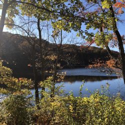
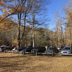
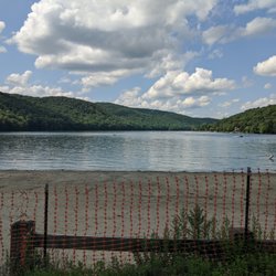
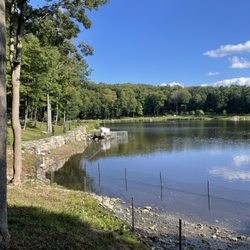
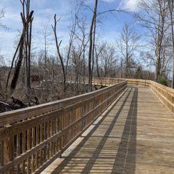
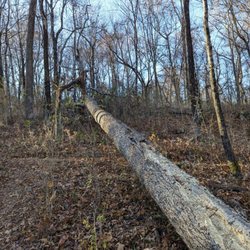
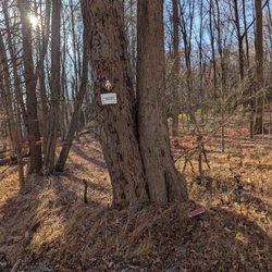
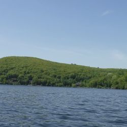
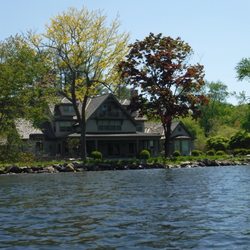
This park is a wonderful choice in Pawling, considering there's quite a bit to do here. There is a road/pathway that's called Holiday Hills Ln, only accessed by authorized vehicles, which follows alongside Green Mountain Lake, and additional trails along it. There are even abandoned barns and buildings along the way, highlighting that. Towards the main parking lot, there is a bathroom house, a mini beach, a tennis court, and even a playground as an alternative. Definitely a must-stop while in Pawling. read more


Even in the middle of a pandemic and extremely brisk temperatures in Nov, this was the perfect spot for me to elope! I got married by the sand overlooking the water on a Sunday afternoon, with 5 of our closest friends, and its was spectacular!! This park is beautiful, great place to just go for a walk, or have a wedding read more

More info about Lakeside Park
2 Lakeside Dr
Pawling, NY 12564
Directions
(845) 855-1131
Call Now
Hours
Outdoor Amenities


Lakeside Park - hiking - Updated June 2026
Best of Pawling
People found Lakeside Park by searching for…
Things to Do in Pawling, New York
Playgrounds in Pawling, New York
Walking Trails in Pawling, New York
Abandoned Buildings in Pawling, New York
Swimming Lakes in Pawling, New York
Places to Take Pictures in Pawling, New York
Water Parks in Pawling, New York
Hiking Trails in Pawling, New York
Urban Exploration in Pawling, New York
Scenic Overlook in Pawling, New York
Lakes & Ponds in Pawling, New York
Abandoned Places in Pawling, New York
Scenic Drive in Pawling, New York
Tennis Courts in Pawling, New York
Scenic View in Pawling, New York
Beautiful Views in Pawling, New York
Waterfalls in Pawling, New York
Running Trails in Pawling, New York
Running Tracks Open to the Public in Pawling, New York
Trending Searches in Pawling, NY
Bait And Tackle Shop near Lakeside Park
Baseball Fields near Lakeside Park
Black Owned Nail Salons near Lakeside Park
Boat Rental near Lakeside Park
Cliff Jumping near Lakeside Park
Dog Friendly Beaches near Lakeside Park
Dog Friendly Trails near Lakeside Park
Fishing Spots near Lakeside Park
Jet Ski Rental near Lakeside Park
Kayak Rental near Lakeside Park
Lakes & Ponds near Lakeside Park
Outdoor Activities near Lakeside Park
Parks With Pull Up Bars near Lakeside Park
Pick Your Own Farms near Lakeside Park
Public Beaches near Lakeside Park
Public Shower near Lakeside Park
River Swimming near Lakeside Park
Rock Quarry near Lakeside Park
Scenic Night View near Lakeside Park
Scenic Overlook near Lakeside Park
Secluded Spots near Lakeside Park
Soccer Store near Lakeside Park
Strawberry Picking near Lakeside Park
Sunrise View near Lakeside Park
Swimming Holes near Lakeside Park
Swimming Lakes near Lakeside Park
Swimming Pools near Lakeside Park
Watch Sunset near Lakeside Park
Browse Nearby
Browse Brands
Related Searches in Pawling, NY
Best Fishing Locations and Guides in Pawling, New York
Best Fun Things to Do in Pawling, New York
Best Off Leash Dog Parks in Pawling, New York
Best Parks for Parties and Events in Pawling, New York
Best Places for Horseback Riding in Pawling, New York
Best Spots for Star Gazing in Pawling, New York
Best Water Parks for Kids in Pawling, New York
Best Waterfalls and Swimming Holes in Pawling, New York
Check Out Great Playgrounds in Pawling, New York
Discover Baseball Fields Around Pawling, New York
Discover Dog Friendly Trails to Explore in Pawling, New York
Discover Lakes & Ponds to Explore in Pawling, New York
Discover Popular Photo Spots in Pawling, New York
Discover Top Boat Tours in Pawling, New York for All Ages
Discover Top State Parks to Visit in Pawling, New York
Discover a Hiking Trail in Pawling, New York
Discover the Best Beaches in Pawling, New York
Discover the Best Night Hike Trails in Pawling, New York
Dog-Friendly Hikes With Dogs in Pawling, New York
Enjoy the Best Picnic Spots and Ideas in Pawling, New York
Enjoy the Best Tubing Experiences in Pawling, New York
Enjoy the Best Walking Trails in Pawling, New York
Exciting Cliff Jumping Spots in Pawling, New York
Explore Beautiful Botanical Gardens in Pawling, New York
Explore Beautiful Parks and Green Spaces in Pawling, New York
Explore Bike Rentals Throughout Pawling, New York
Explore Family-Friendly Zoos and Wildlife in Pawling, New York
Explore Free Picnic Areas Around Pawling, New York
Explore Landmarks & Historical Buildings in Pawling, New York
Explore Parks With Pull Up Bars in Pawling, New York
Explore Popular Campgrounds Near Pawling, New York
Explore Popular Picnic Areas Around Pawling, New York
Explore Popular RV Parks Around Pawling, New York
Explore Popular Scenic Overlook Points in Pawling, New York
Explore Popular Scenic Views Near Pawling, New York
Explore Scenic Lakes to Visit in Pawling, New York
Explore Secret Spots Worth Visiting in Pawling, New York
Explore Top Dog Parks in Pawling, New York Near You
Explore Top Gyms in Pawling, New York Now
Explore Top Water Parks in Pawling, New York Today
Explore the Best Beach Spots in Pawling, New York
Explore the Best Boating Spots in Pawling, New York
Explore the Best Swimming Holes Around Pawling, New York
Find Beautiful Views in Pawling, New York
Find Popular Ziplining Spots Around Pawling, New York
Find Top Dog Friendly Parks to Visit in Pawling, New York
Find Top Skate Parks in Pawling, New York for All Skill Levels
Find Top Skating Rinks in Pawling, New York for All Ages