Kennedy Meadows Photos


You might also consider
More like Kennedy Meadows
Recommended Reviews - Kennedy Meadows
Start your review...


3 years ago
This is a review for the food at the restaurant. I'll definitely be back. The burger and breakfast plate was fresh and amazing. I almost wanted to get another burger. read more


2 days ago
9 months ago
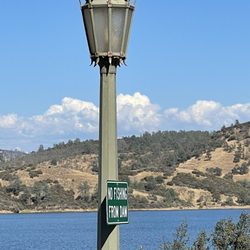
My resupply on the PCT at Kennedy Meadows turned into a mini vacation that I'll look back fondly on for years. I took advantage of the shuttle they run from Sonora pass to the resort. I called to confirm the pickup time, and it was right on schedule. The guy driving the van was filling in for the usual driver, but he was professional and shared some cool facts about the area. At the resort he pointed me towards the designated hiker hangout area and let me know where the front desk was so I could work out accommodations. I had my heart set on a cabin to nurse my chewed up feet and wait for my replacement shoes to arrive via FedEx, but they were totally booked up. The woman at the front desk was awesome though and told me she'd put me in an empty dorm and try to let me have it to myself as long as possible. Picking up my resupply at the general store was easy, and the hiker area was convenient for repacking my bag. The general store had a great selection of all the typical hiker foods, and tons of great snacks. Laundry was a little chaotic because people (workers and hikers) were leaving their finished loads in the machines for ages, but eventually all my chores were done and I was able to relax in the restaurant. There was only one server working but she was friendly and kicking butt. The burger made with their own beef was great. After retiring to my dorm to kill many hours using the strong WiFi, I came back down to the restaurant seeking dinner. The days they offer prime rib are a bit of a madhouse because people travel specifically for the occasion. I couldn't get the attention of any server so I went back to my room. I came back closer to closing and was able to awkwardly shuffle in. The prime rib dinner was massive and pretty good. Even with my hiker hunger I wasn't able to finish it. The generator is LOUD, but you generally get used to it. When it slams off at night the silence is welcomed but jarring. The WiFi still works though. The next morning the restaurant was bustling for breakfast. It always seems like there's never quite enough servers, but that's not surprising considering it's a remote resort. I signed up for one of the short trail rides for a very reasonable $35. I turned out to be the only guest taking that particular ride, which was fun if not a little awkward. The guide was extremely professional and did a good job giving me directions and keeping an eye on how my saddle was positioned and how my horse was behaving. It was a beautiful short ride with a little bit of surprising rocky terrain and creek crossings. The rest of my second day at KM was spent in the saloon waiting for my shoes to arrive. Even though they recommend UPS, FedEx managed to arrive on schedule and my feet were saved. The bar had a great vibe with its strictly western jukebox and friendly barkeep. Dinner on a weekday was much less chaotic, and the ribeye was delicious. The next morning the shuttle driver struck a deal to take someone to a nearby town, so the shuttle was off schedule. Luckily the backpackers spread the word amongst ourselves and after sending a package home with the front desk, I wound up back at Sonora pass in the morning as planned, probably a few pounds heavier. I highly recommend Kennedy Meadows as a resupply and zero spot. They're extremely honest and upfront about how much everything they offer costs, and I didn't feel looked down on for being a smelly hiker. It's a beautiful area, and I plan on coming back for a vacation someday and getting my hands on one of those cabins! read more


1 year ago
Our family's been going here since 1972!!! We absolutely LOVEI IT!! Camping cabins horseback riding camp fires great food at their restaurant. Gorgeous Views everywhere!!! read more


6 years ago
6 years ago
6 years ago
9 years ago
Disneyland for enduro riders, single track heaven , best place to ride in the summer , camping at its best ! Red and green sticker friendly ! read more


14 years ago
8 years ago
11 years ago
More info about Kennedy Meadows
California 108
East Sonora, CA 95370
Directions
(209) 965-3900
Call Now
Visit Website
http://www.kennedymeadows.com
Hours
Outdoor Amenities
Other Amenities
Ask the Community - Kennedy Meadows
Review Highlights - Kennedy Meadows


Kennedy Meadows - hiking - Updated July 2026
Best of East Sonora
People found Kennedy Meadows by searching for…
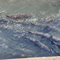
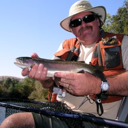
Trout Fishing in East Sonora, CA
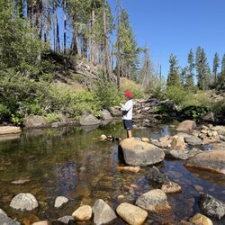
Hiking Trails in East Sonora, CA
Things to Do in East Sonora, CA
Camping Sites in East Sonora, CA
Fishing Spots in East Sonora, CA
River Swimming in East Sonora, CA
Fishing Guides in East Sonora, CA
Fly Fishing Shop in East Sonora, CA
Picnic Areas in East Sonora, CA
Watch Sunset in East Sonora, CA
Redwood Trees in East Sonora, CA
Lakes & Ponds in East Sonora, CA
Picnic Areas BBQ Pits in East Sonora, CA
Fishing Rental in East Sonora, CA
Public Shower in East Sonora, CA
Trending Searches in East Sonora, CA
Beautiful Views near Kennedy Meadows
Black Owned Nail Salons near Kennedy Meadows
Boat Rental near Kennedy Meadows
Day Trips near Kennedy Meadows
Dog Swimming near Kennedy Meadows
Fishing Supplies near Kennedy Meadows
Jet Ski Rental near Kennedy Meadows
Kayak Rental near Kennedy Meadows
Lakes & Ponds near Kennedy Meadows
Long Term Rv Parking near Kennedy Meadows
Off Road Trails near Kennedy Meadows
Outdoor Activities near Kennedy Meadows
Picnic Spots near Kennedy Meadows
Public Pools near Kennedy Meadows
Public Shower near Kennedy Meadows
River Swimming near Kennedy Meadows
River Tubing near Kennedy Meadows
Running Trails near Kennedy Meadows
Rv Campgrounds near Kennedy Meadows
Soccer Store near Kennedy Meadows
Splash Pad near Kennedy Meadows
Swimming Holes near Kennedy Meadows
Swimming Lakes near Kennedy Meadows
U Pick Farms near Kennedy Meadows
Browse Articles
Browse Nearby
Browse Brands
Related Cost Guides
Related Searches in East Sonora, CA
Affordable Fishing Rental Services in East Sonora, California
Affordable Jet Ski Rental Options in East Sonora, California
Affordable Kayak Rental Services in East Sonora, California
Affordable Long Term RV Parking in East Sonora, California
Affordable RV Rental Options in East Sonora, California
Best Fishing Locations and Guides in East Sonora, California
Best Fun Things to Do in East Sonora, California
Best Places for Horseback Riding in East Sonora, California
Best RV Dump Stations Available in East Sonora, California
Best Sledding Spots and Fun in East Sonora, California
Best Spots for Star Gazing in East Sonora, California
Best Waterfalls and Swimming Holes in East Sonora, California
Browse Top Hotels in East Sonora, California for Your Stay
Browse Vacation Rentals to Book in East Sonora, California
Discover Dog Friendly Trails to Explore in East Sonora, California
Discover Free Campgrounds in East Sonora, California Area
Discover Fun Activities to Do in East Sonora, California
Discover Lakes & Ponds to Explore in East Sonora, California
Discover Scenic Beach Camping Sites in East Sonora, California
Discover Scenic Mountain Bike Trails Near East Sonora, California
Discover a Hiking Trail in East Sonora, California
Discover the Best Beaches in East Sonora, California
Discover the Best Fishing Lake in East Sonora, California
Dog-Friendly Hikes With Dogs in East Sonora, California
Enjoy Camping Adventures Around East Sonora, California
Enjoy Fishing Pier Spots in East Sonora, California With Scenic Views
Enjoy Fishing With Kids in East Sonora, California Safely
Enjoy Hiking Adventures in East Sonora, California
Enjoy a Relaxing Bed & Breakfast Experience in East Sonora, California
Enjoy the Best Tubing Experiences in East Sonora, California
Enjoy the Best Walking Trails in East Sonora, California
Experience Deep Sea Fishing Adventures in East Sonora, California
Experience Thrilling White Water Rafting in East Sonora, California
Experience the Best Family Fun in East Sonora, California for All
Experienced Fishing Guides Available in East Sonora, California
Explore Beautiful Parks and Green Spaces in East Sonora, California
Explore Bike Rentals Throughout East Sonora, California
Explore Easy Hikes Perfect for All in East Sonora, California
Explore Fun Activities to Do in East Sonora, California
Explore Hotels & Travel Options in East Sonora, California
Explore Mobile Home Parks in East Sonora, California Now
Explore Popular Campgrounds Near East Sonora, California
Explore Popular Picnic Areas Around East Sonora, California
Explore Scenic Lakes to Visit in East Sonora, California
Explore Secret Spots Worth Visiting in East Sonora, California
Explore Summer Camps for All Ages in East Sonora, California
Explore Top Dog Parks in East Sonora, California Near You
Explore Top Water Parks in East Sonora, California Today