Jung Ranch Trail Photos


You might also consider
More like Jung Ranch Trail
Recommended Reviews - Jung Ranch Trail
Start your review...

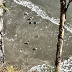
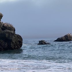
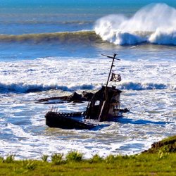
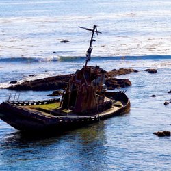
People say there's nothing to do in San Simeon except Hearst Castle...Of course, those with inside knowledge know where the cool non-touristy stuff can be found. Where.. The Jung Ranch Trail has two entry points where you can park and hike. The most accessible starting point (perfect for those staying in the area's motels) is at the end of 271 Vista Del Mar Ave. The other end of this trail is off Lone Palm Dr. The Hike.. The Jung trail about 1 mile in length from endpoint to endpoint. For the most part, it's pretty flat and could be easily walked by most people. This trail goes along San Simeon's breezy beach cliffs with plenty of access to the beach and the tide pools below. The Tide Pools.. If you have kids be sure to come here around low tide. While the specimens not be amazing when compared to other famous tide pools, there are crabs and sea anemones everywhere. You'll like see a sea lion of the farther out rocks. The kids said this was the highlight of our most recent trip. Know this! It can be very windy and cold on this trail. Dress appropriately. Definitely snakes in the field so stay on the path.. read more


This trail isn't far from Hwy 1. There is a small area on a side road to the North park, or a longer side road on the south end to park. you can walk the trail which I believe is around 2-3 miles. We saw the pictures of the tide pools so was hoping to see something. So we made our way down and was walking the tide-pools getting looks as if we were nuts because the waves were big so we had to wait until the wave went down to walk a little bit, stop, and go again. But we didn't see anything in the tide-pools. read more


More info about Jung Ranch Trail
You might also consider


Jung Ranch Trail - hiking - Updated May 2026
Best of San Simeon
People found Jung Ranch Trail by searching for…
Trending Searches in San Simeon, CA
Baseball Fields near Jung Ranch Trail
Boat Rental near Jung Ranch Trail
Botanical Gardens near Jung Ranch Trail
Bounce House Rentals near Jung Ranch Trail
Campgrounds near Jung Ranch Trail
Cliff Jumping near Jung Ranch Trail
Flower Fields near Jung Ranch Trail
Flower Shop near Jung Ranch Trail
Garage Sales near Jung Ranch Trail
Garden Center near Jung Ranch Trail
Graduation Leis near Jung Ranch Trail
Mountain Bike Trails near Jung Ranch Trail
Nurseries & Gardening near Jung Ranch Trail
Outdoor Activities near Jung Ranch Trail
Outdoor Furniture Stores near Jung Ranch Trail
Party Equipment Rentals near Jung Ranch Trail
Pedicure near Jung Ranch Trail
Photo Spots near Jung Ranch Trail
Picnic Areas near Jung Ranch Trail
Places To Take Pictures near Jung Ranch Trail
Rock Quarry near Jung Ranch Trail
Running Trails near Jung Ranch Trail
Rv Rental near Jung Ranch Trail
Scenic Drive near Jung Ranch Trail
Sunrise View near Jung Ranch Trail
Swimming Holes near Jung Ranch Trail
Table And Chair Rentals near Jung Ranch Trail
Browse Articles
Browse Nearby
BEST of San Simeon, California Parks near Jung Ranch Trail
BEST of San Simeon, California Coffee near Jung Ranch Trail
BEST of San Simeon, California Restaurants near Jung Ranch Trail
BEST of San Simeon, California Things to Do near Jung Ranch Trail
BEST of San Simeon, California Scenic View near Jung Ranch Trail
BEST of San Simeon, California Breakfast near Jung Ranch Trail
BEST of San Simeon, California Campgrounds near Jung Ranch Trail
BEST of San Simeon, California Visitor Centers near Jung Ranch Trail
BEST of San Simeon, California Sightseeing near Jung Ranch Trail
Browse Brands
Related Searches in San Simeon, CA
Affordable Kayak Rental Services in San Simeon, California
Best Fun Things to Do in San Simeon, California
Best Places for Horseback Riding in San Simeon, California
Check Out Off Road Trails in San Simeon, California
Discover Dog Friendly Trails to Explore in San Simeon, California
Discover Scenic Mountain Bike Trails Near San Simeon, California
Discover Top Boat Tours in San Simeon, California for All Ages
Discover Top State Parks to Visit in San Simeon, California
Discover a Hiking Trail in San Simeon, California
Discover the Best Night Hike Trails in San Simeon, California
Dog-Friendly Hikes With Dogs in San Simeon, California
Enjoy Camping Adventures Around San Simeon, California
Enjoy Kayaking Adventures in San Simeon, California
Enjoy Water Activities and Fun in San Simeon, California
Enjoy a Beautiful Waterfall Hike in San Simeon, California
Enjoy a Dog Beach Day in San Simeon, California
Enjoy a Scenic Walk in San Simeon, California
Enjoy the Best Picnic Spots and Ideas in San Simeon, California
Enjoy the Best Walking Trails in San Simeon, California
Exciting Cliff Jumping Spots in San Simeon, California
Explore Beautiful Parks and Green Spaces in San Simeon, California
Explore Bike Rentals Throughout San Simeon, California
Explore Easy Hikes Perfect for All in San Simeon, California
Explore Fun Activities to Do in San Simeon, California
Explore Popular Campgrounds Near San Simeon, California
Explore Popular View Points Around San Simeon, California
Explore Top Dog Parks in San Simeon, California Near You
Explore the Best Beach Spots in San Simeon, California
Explore the Best Boating Spots in San Simeon, California
Explore the Best Swimming Holes Around San Simeon, California
Family Friendly Hiking With Kids in San Simeon, California
Find Cozy Camping Cabins in San Simeon, California
Find Popular Ziplining Spots Around San Simeon, California
Find Top Dog Swimming Spots in San Simeon, California
Find the Best Playgrounds to Visit in San Simeon, California
Find the Best Scenic View Locations in San Simeon, California
Hiking Trails With Waterfalls in San Simeon, California
Plan Nature Center Visits in San Simeon, California
Plan a Scenic Drive Route Near San Simeon, California
Popular Fishing Spots to Explore in San Simeon, California
Popular Picnic Spots to Visit in San Simeon, California
Popular Things to Do in San Simeon, California
Safe River Swimming Areas in San Simeon, California
Safe and Fun Parks for Kids in San Simeon, California
Top Paddleboarding Activities in San Simeon, California
Top Places for Snorkeling in San Simeon, California
Top Playgrounds for Kids to Enjoy in San Simeon, California
Top Running Trails to Explore in San Simeon, California