Ipcar Natural Preserve Photos


You might also consider
More like Ipcar Natural Preserve
Recommended Reviews - Ipcar Natural Preserve
Start your review...

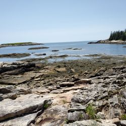
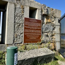
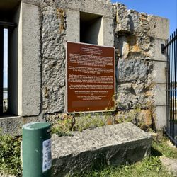
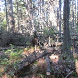
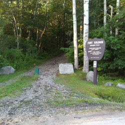
While driving up, down, and around the coast of Maine this summer (because sometimes you just have to take a road trip with no destination in mind) we found ourselves at Five Island Lobster Co. Looking for parking before walking around the nearby rocky coastal ledge, we ended up at a spot near a tennis court and a small woodland area with a pond called Ipcar Natural Preserve. According to a nearby sign, Georgetown "acquired these 33 acres from Maud Steussy in 1973 as part of the Five Island Waterfront Properties for the enjoyment of present and future generations. The town voted in 1994 to name the preserve in honor of Adolph Ipcar, chairman of the conservation commission, who obtained grants from the state and federal governments and led the drive for donations, advised and assisted by Ed Pert and Lloyd Pinkham." We sat for quite a while on one of the benches just absorbing nature. While everyone else behind us streamed past this peaceful spot for their steamed lobsters, we watched the ducks be ducks, frogs eat flies, and tiny fish dart back and forth - all existing quietly in their element while nearby a swarm of tourists stuffed their faces. The irony. It was such a nice way to spend time after driving for so long. The absolute definition of a hidden gem, especially if you like nature. Remember: that's all this is (a bench overlooking woods and a pond... sometimes that's all you need, though, right?). Bring a book, bring your lunch, and enjoy the outdoors. read more


10 years ago
More info about Ipcar Natural Preserve
Ballfield Ln
Georgetown, ME 04548
Directions
Hours
Outdoor Amenities


Ipcar Natural Preserve - parks - Updated July 2026
Best of Georgetown
People found Ipcar Natural Preserve by searching for…
Things to Do in Georgetown, Maine
Playgrounds in Georgetown, Maine
Secret Spots in Georgetown, Maine
Fishing Spots in Georgetown, Maine
Walking Trails in Georgetown, Maine
Lakes & Ponds in Georgetown, Maine
Places to Take Pictures in Georgetown, Maine
Tennis Courts in Georgetown, Maine
Playgrounds for Kids in Georgetown, Maine
Photo Spots in Georgetown, Maine
Parks for Kids in Georgetown, Maine
Hiking Trails in Georgetown, Maine
Picnic Spots in Georgetown, Maine
Scenic Drive in Georgetown, Maine
View Points in Georgetown, Maine
Outdoor Basketball Courts in Georgetown, Maine
Scenic Overlook in Georgetown, Maine
Lookout Points in Georgetown, Maine
Scenic Night View in Georgetown, Maine
Browse Nearby
BEST of Georgetown, Maine Things to Do near Ipcar Natural Preserve
BEST of Georgetown, Maine Restaurants near Ipcar Natural Preserve
BEST of Georgetown, Maine Coffee near Ipcar Natural Preserve
BEST of Georgetown, Maine Playgrounds near Ipcar Natural Preserve
BEST of Georgetown, Maine Hiking near Ipcar Natural Preserve
BEST of Georgetown, Maine Campgrounds near Ipcar Natural Preserve
BEST of Georgetown, Maine Breakfast near Ipcar Natural Preserve
BEST of Georgetown, Maine Resorts near Ipcar Natural Preserve
Browse Brands
Browse Articles
People who viewed Ipcar Natural Preserve also viewed
Baxter Woods
13 reviews
Deering Center
Thorncrag Bird Sanctuary
5 reviews
Knight's Pond Preserve
1 review
Mercy Pond Loop Trail
1 review
Valley Street
Fort Allen Park
20 reviews
East End
River Point Conservation Area
1 review
Beaver Park
2 reviews
Forest City Trail
2 reviews
Old Port
Thomas Knight Park
2 reviews
White Head Trail
2 reviews