Gwynns Falls Trail Photos


You might also consider
More like Gwynns Falls Trail
Recommended Reviews - Gwynns Falls Trail
Start your review...

8 years ago
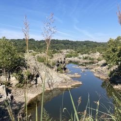
This portion of Gwynn Falls Trail is located between the Horseshoe Casino and M&T Stadium in Baltimore City. I assume it is part of the T7 to T8 portion of the trail. I visited twice before reviewing to be fair. It is unkempt and dreary. In the shadows of the casino is a tent city with people living in the woods. Despair is overwhelming. Trash and debris fills the water around the casino. There is potential to be a beautiful park but it would require a lot of attention and commitment. read more


More info about Gwynns Falls Trail
You might also consider


Why does Yelp recommend reviews?
1 review that is not currently recommended
The reviews below are not factored into the business's overall star rating.
7 months ago
Gwynns Falls Trail - hiking - Updated May 2026
Best of Baltimore
People found Gwynns Falls Trail by searching for…
Fishing in Baltimore, Maryland
Cliff Jumping in Baltimore, Maryland
Playgrounds in Baltimore, Maryland
Scenic View in Baltimore, Maryland
Walking Trails in Baltimore, Maryland
Hiking Trails With Waterfalls in Baltimore, Maryland
Picnic Areas in Baltimore, Maryland
River Swimming in Baltimore, Maryland
Cruising Spots in Baltimore, Maryland
Fishing Spots in Baltimore, Maryland
Urban Exploration in Baltimore, Maryland
Scenic Drive in Baltimore, Maryland
Places to Take Pictures in Baltimore, Maryland
Water Parks in Baltimore, Maryland
Running Trails in Baltimore, Maryland
Dog Swimming in Baltimore, Maryland
Beautiful Views in Baltimore, Maryland
Train Ride Kids in Baltimore, Maryland
Off Road Trails in Baltimore, Maryland
Park With BBQ Pits in Baltimore, Maryland
Scenic Overlook in Baltimore, Maryland
Sunset View in Baltimore, Maryland
Trending Searches in Baltimore, MD
Baseball Fields near Gwynns Falls Trail
Botanical Gardens near Gwynns Falls Trail
Bounce House Rentals near Gwynns Falls Trail
Campgrounds near Gwynns Falls Trail
Cherry Picking near Gwynns Falls Trail
Cliff Jumping near Gwynns Falls Trail
Floral Designers near Gwynns Falls Trail
Flower Fields near Gwynns Falls Trail
Flower Shop near Gwynns Falls Trail
Garage Sales near Gwynns Falls Trail
Garden Center near Gwynns Falls Trail
Lakes & Ponds near Gwynns Falls Trail
Mens Suits near Gwynns Falls Trail
Nurseries & Gardening near Gwynns Falls Trail
Outdoor Activities near Gwynns Falls Trail
Outdoor Basketball Courts near Gwynns Falls Trail
Outdoor Furniture Stores near Gwynns Falls Trail
Parks For Parties near Gwynns Falls Trail
Party Equipment Rentals near Gwynns Falls Trail
Pedicure near Gwynns Falls Trail
Photo Spots near Gwynns Falls Trail
Picnic Areas near Gwynns Falls Trail
Places To Take Pictures near Gwynns Falls Trail
Plant Nursery near Gwynns Falls Trail
Playgrounds near Gwynns Falls Trail
Public Running Track near Gwynns Falls Trail
Public Shower near Gwynns Falls Trail
Rock Quarry near Gwynns Falls Trail
Running Trails near Gwynns Falls Trail
Scenic Drive near Gwynns Falls Trail
Scenic Night View near Gwynns Falls Trail
Sunrise View near Gwynns Falls Trail
Swimming Holes near Gwynns Falls Trail
Table And Chair Rentals near Gwynns Falls Trail
Tennis Courts near Gwynns Falls Trail
Browse Nearby
BEST of Baltimore, Maryland Coffee near Gwynns Falls Trail
BEST of Baltimore, Maryland Restaurants near Gwynns Falls Trail
BEST of Baltimore, Maryland Things to Do near Gwynns Falls Trail
BEST of Baltimore, Maryland Breakfast near Gwynns Falls Trail
BEST of Baltimore, Maryland Parks near Gwynns Falls Trail
BEST of Baltimore, Maryland Hotels near Gwynns Falls Trail
Browse Brands
Related Searches in Baltimore, MD
Affordable Kayak Rental Services in Baltimore, Maryland
Best Fishing Locations and Guides in Baltimore, Maryland
Best Off Leash Dog Parks in Baltimore, Maryland
Best Parks for Parties and Events in Baltimore, Maryland
Best Places for Horseback Riding in Baltimore, Maryland
Best Water Parks for Kids in Baltimore, Maryland
Best Waterfalls and Swimming Holes in Baltimore, Maryland
Check Out Great Playgrounds in Baltimore, Maryland
Check Out Off Road Trails in Baltimore, Maryland
Discover Baseball Fields Around Baltimore, Maryland
Discover Beautiful Garden Spots in Baltimore, Maryland
Discover Dog Friendly Trails to Explore in Baltimore, Maryland
Discover Free Parking Options in Baltimore, Maryland
Discover Fun Outdoor Playgrounds for Kids in Baltimore, Maryland, {State}
Discover Fun Toddler Parks in Baltimore, Maryland for Your Little One
Discover Kid Friendly Hiking Trails in Baltimore, Maryland
Discover Lakes & Ponds to Explore in Baltimore, Maryland
Discover Popular Photo Spots in Baltimore, Maryland
Discover Scenic Mountain Bike Trails Near Baltimore, Maryland
Discover Scenic Waterfall Spots in Baltimore, Maryland
Discover Soccer Fields in Baltimore, Maryland Near You
Discover Top Nature Parks to Visit in Baltimore, Maryland
Discover Top State Parks to Visit in Baltimore, Maryland
Discover Walking Parks in Baltimore, Maryland Near You
Discover a Hiking Trail in Baltimore, Maryland
Discover the Best Beaches in Baltimore, Maryland
Discover the Best Kids Park Spots in Baltimore, Maryland
Discover the Best Night Hike Trails in Baltimore, Maryland
Dog-Friendly Hikes With Dogs in Baltimore, Maryland
Enjoy Camping Adventures Around Baltimore, Maryland
Enjoy Exciting Mountain Biking Adventures in Baltimore, Maryland
Enjoy Kayaking Adventures in Baltimore, Maryland
Enjoy Tent Camping Spots Around Baltimore, Maryland
Enjoy a Beautiful Waterfall Hike in Baltimore, Maryland
Enjoy the Best Picnic Spots and Ideas in Baltimore, Maryland
Enjoy the Best Tubing Experiences in Baltimore, Maryland
Enjoy the Best Walking Trails in Baltimore, Maryland
Exciting Cliff Jumping Spots in Baltimore, Maryland
Experience Thrilling White Water Rafting in Baltimore, Maryland
Explore Beautiful Parks and Green Spaces in Baltimore, Maryland
Explore Easy Hikes Perfect for All in Baltimore, Maryland
Explore Family-Friendly Zoos and Wildlife in Baltimore, Maryland
Explore Free Picnic Areas Around Baltimore, Maryland
Explore Fun Activities to Do in Baltimore, Maryland
Explore Parks With Pull Up Bars in Baltimore, Maryland
Explore Popular Campgrounds Near Baltimore, Maryland
Explore Popular Picnic Areas Around Baltimore, Maryland
Explore Popular RV Parks Around Baltimore, Maryland
Explore Popular Recreation Centers Around Baltimore, Maryland
Explore Popular Scenic Overlook Points in Baltimore, Maryland
Browse Articles
People who viewed Gwynns Falls Trail also viewed
James W Rouse Memorial Deck At Round Falls
10 reviews
Jones Falls Area
Trolley Trail
14 reviews
North Point State Park
31 reviews
Patapsco Valley State Park - McKeldin Area
20 reviews
Patapsco Valley State Park - Hilton Area
20 reviews
Red Run Stream Valley Trail
11 reviews
Loch Raven Reservoir
17 reviews
Ole Ranger Trail
3 reviews
Masonville Cove Environmental Education Center
1 review
Fairfield Area
Meadow Creek Park
1 review