Grimes Point Archeological Site Photos


More like Grimes Point Archeological Site
Recommended Reviews - Grimes Point Archeological Site
Start your review...

Reviews With Photos


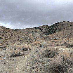
Grimes Point was a pretty decent hike. The trails are well-seen so you can't really get lost. We did veer off a bit but nothing bad. Once you get up on the overlook, you can get some really nice views and on a good day, it makes for some really good pictures. There is parking, picnics tables, and restrooms. If you bring your pets, PLEASE pick up after them!! There is dog poop all around.

Great spot to hike and discover with kids (mine are 8 and 11). Allow about 1-2 hours to walk around leisurely. Bring water. No drinking water fountains- but there are restrooms. There are designated Saturdays that offer guided tours of hidden cave... we will have to take advantage of that next time. The cave tour starts at the Fallon museum back in town.

I been living in Nevada for about 14 years, and I just found out today about this place by a local fallon Business owner, after talking to her My son and I decided to go check it out. Wow, the views are just breathtaking. 3 things I will reccomend: 1.- Visit this place early spring, fall or winter. It was kind of hot today. 2.- if you decide not to wait till fall, come in quite early or late in the afternoon. 3.- There's so much Beauty, come prepared to take lots of pictures. I will definitely come back and go to see the other 2 caves I missed. I hope this review will be helpful

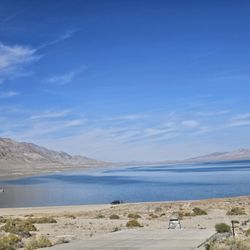
Located about seven miles east of Fallon, Nevada, on the north side of Highway 50, the Grimes Point petroglyphs may get more visitors now that interpretative signage and better restroom facilities make this highway-side location a convenient rest stop for travelers. Many of the petroglyphs here are about 6,000 years old and were made at a time when water was still plentiful in the region. While standing in the parking lot, it might not appear that the relatively short trail ahead will reveal many examples of rock art. If you keep your eyes open on the boulders at your feet along the trail, though, you'll still find some faded but wonderful images. Time is having its way with our connection to an ancient people -- and acts of vandalism have only hastened the process -- but you still have a chance to glimpse into the past if you are willing to allow yourself an hour or two. I've not had the opportunity to take a tour of the adjacent Hidden Cave, a supposed archeological treasure trove, that takes place a few times a month at selected times of the year. The Churchill County Museum in Fallon organizes these tours and I hope to catch a tour in the future.

If you don't mind a really long drive out to the middle no where this is a great place to spend the day. I recommend going really early in the day during the warmer or hot parts of the year. There are two places to start hiking from. One is just right off the main high way is a picnic area with a trail head, or you can go a little further and hike up to the cave. The cave is only open on select days so I recommend looking at the website for the days that is open with a guide. On both of my trips out here with my older girls and their classes we were able to watch the Fallon Naval Air Station pilots practice taking off and landing on the back run way. We had a lot of fun and will be back when it cools off a little more during the day to go hiking again.

Nice hike! You have 2 trail options. The Petroglyph Trail is an easy walk & is wheelchair accessible (according to the signs). I would say that because of some of the inclines a sport wheelchair may be required, not hospital quality ones. The rock carvings are hard to see & some are a little ways off the trail. This trail keeps you to the lower part of the mountain & is fairly short. The Overlook Trail is a little more than 2 miles from the base/parking lot. At some points it's hard to see where the trail is leading & multiple trails have been carved out going in different directions. It's so flat out there though that there's no way you'd get 'lost'. The view from the top is good & on one of the mountains you will find a bench & 3 plaques providing information on the Lohantan Valley & comparing yesterday & today. It's good reading for a break before you head back. The hike down is CAKE :) I've been here twice now. The first time I only did a quick run through the Petroglyph Trail,,,, I was wearing flip flops & hadn't brought any water because I hadn't expected to stop, so I decided to come back another day to do the both trails. I did that today & I liked doing both SO much better! It made it worth the drive. The tennis shoes & water helped make it more comfortable & enjoyable :D There are bathrooms & picnic tables in the parking lot, so feel free to bring something to snack on after or before your hike.

An amazing find. Well preserved and maintained. Trail and area is protected and maintained by BLM. Walking along the trail to the petroglyphs the desert beauty surrounds you. Keep an eye out for snakes. The trail is about 3 miles round trip. Easy to walk, bring water with you and a charged phone! (No pictures because mine was not charged!). As you look at the drawings imagine living during that era and how rough life was for survival. Worth the stop and plan at least an hour to explore. We stayed almost 4 hours. read more


Camped here on the 15th, arrived at night and the stars were immaculate. We picked a spot way past the hidden cave just because we were traveling to Berlin State Park the next day. We were not disturbed and slept in our truck bed. This area is really pretty, still close to Fallon of you need supplies. The hidden cave trail loop is a special treat out here. The hidden cave is only open for tours on the weekend, but we still walked through the smaller caves that are always open. Lots on informative signage! We were the only ones on the whole trail loop which was a plus. There's a cute picnic area at the entrance. The people in town were very nice and we also got to see jets taking of from the airbase. We are aviation needs so this was a great experience. We will definitely come dispersed camping here in the future. read more


This was such a cool stop!!! We came by and did just the smaller loop after visiting Hidden Cave. Our kids (5, 9, 10, and 11) enjoyed looking for petroglyphs, and we learned about different kinds of petroglyphs on the interpretive trail. Highly recommend!! read more


Grimes Point was a pretty decent hike. The trails are well-seen so you can't really get lost. We did veer off a bit but nothing bad. Once you get up on the overlook, you can get some really nice views and on a good day, it makes for some really good pictures. There is parking, picnics tables, and restrooms. If you bring your pets, PLEASE pick up after them!! There is dog poop all around. read more


6 years ago
Great spot to hike and discover with kids (mine are 8 and 11). Allow about 1-2 hours to walk around leisurely. Bring water. No drinking water fountains- but there are restrooms. There are designated Saturdays that offer guided tours of hidden cave... we will have to take advantage of that next time. The cave tour starts at the Fallon museum back in town. read more


I been living in Nevada for about 14 years, and I just found out today about this place by a local fallon Business owner, after talking to her My son and I decided to go check it out. Wow, the views are just breathtaking. 3 things I will reccomend: 1.- Visit this place early spring, fall or winter. It was kind of hot today. 2.- if you decide not to wait till fall, come in quite early or late in the afternoon. 3.- There's so much Beauty, come prepared to take lots of pictures. I will definitely come back and go to see the other 2 caves I missed. I hope this review will be helpful read more


Located about seven miles east of Fallon, Nevada, on the north side of Highway 50, the Grimes Point petroglyphs may get more visitors now that interpretative signage and better restroom facilities make this highway-side location a convenient rest stop for travelers. Many of the petroglyphs here are about 6,000 years old and were made at a time when water was still plentiful in the region. While standing in the parking lot, it might not appear that the relatively short trail ahead will reveal many examples of rock art. If you keep your eyes open on the boulders at your feet along the trail, though, you'll still find some faded but wonderful images. Time is having its way with our connection to an ancient people -- and acts of vandalism have only hastened the process -- but you still have a chance to glimpse into the past if you are willing to allow yourself an hour or two. I've not had the opportunity to take a tour of the adjacent Hidden Cave, a supposed archeological treasure trove, that takes place a few times a month at selected times of the year. The Churchill County Museum in Fallon organizes these tours and I hope to catch a tour in the future. read more


9 years ago
If you don't mind a really long drive out to the middle no where this is a great place to spend the day. I recommend going really early in the day during the warmer or hot parts of the year. There are two places to start hiking from. One is just right off the main high way is a picnic area with a trail head, or you can go a little further and hike up to the cave. The cave is only open on select days so I recommend looking at the website for the days that is open with a guide. On both of my trips out here with my older girls and their classes we were able to watch the Fallon Naval Air Station pilots practice taking off and landing on the back run way. We had a lot of fun and will be back when it cools off a little more during the day to go hiking again. read more


5 years ago
Nice hike! You have 2 trail options. The Petroglyph Trail is an easy walk & is wheelchair accessible (according to the signs). I would say that because of some of the inclines a sport wheelchair may be required, not hospital quality ones. The rock carvings are hard to see & some are a little ways off the trail. This trail keeps you to the lower part of the mountain & is fairly short. The Overlook Trail is a little more than 2 miles from the base/parking lot. At some points it's hard to see where the trail is leading & multiple trails have been carved out going in different directions. It's so flat out there though that there's no way you'd get 'lost'. The view from the top is good & on one of the mountains you will find a bench & 3 plaques providing information on the Lohantan Valley & comparing yesterday & today. It's good reading for a break before you head back. The hike down is CAKE :) I've been here twice now. The first time I only did a quick run through the Petroglyph Trail,,,, I was wearing flip flops & hadn't brought any water because I hadn't expected to stop, so I decided to come back another day to do the both trails. I did that today & I liked doing both SO much better! It made it worth the drive. The tennis shoes & water helped make it more comfortable & enjoyable :D There are bathrooms & picnic tables in the parking lot, so feel free to bring something to snack on after or before your hike. read more


3 years ago
9 years ago
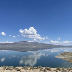
Been to a few petroglyphs sites here in Northern California and Nevada. The age and area are spectacular. You can totally imagine and transport yourself to 10,000 years ago when the ancient Lake Lahontan was there. Okay, I am a history geek. read more


8 years ago
5 years ago
More info about Grimes Point Archeological Site
Highway 50
7 miles East of Fallon
Fallon, NV 89406
Directions
(775) 885-6000
Call Now
Hours
Outdoor Amenities
Ask the Community - Grimes Point Archeological Site
Review Highlights - Grimes Point Archeological Site


Grimes Point Archeological Site - hiking - Updated July 2026
Best of Fallon
People found Grimes Point Archeological Site by searching for…
Things to Do in Fallon, Nevada
Places to Take Pictures in Fallon, Nevada
Walking Trails in Fallon, Nevada
Scenic Views in Fallon, Nevada
Parks for Kids in Fallon, Nevada
Picnic Tables in Fallon, Nevada
Free Parking in Fallon, Nevada
Running Trails in Fallon, Nevada
Camping Sites in Fallon, Nevada
Lakes & Ponds in Fallon, Nevada
Lookout Points in Fallon, Nevada
Off Road Trails in Fallon, Nevada
Things to See in Fallon, Nevada
Hiking Trails in Fallon, Nevada
Picnic Areas in Fallon, Nevada
Nature Walks in Fallon, Nevada
Trending Searches in Fallon, NV
Fireworks near Grimes Point Archeological Site
Hiking Trails With Waterfalls near Grimes Point Archeological Site
Off Road Trails near Grimes Point Archeological Site
Photo Spots near Grimes Point Archeological Site
Places To Swim near Grimes Point Archeological Site
Public Pools near Grimes Point Archeological Site
River Swimming near Grimes Point Archeological Site
Splash Pad near Grimes Point Archeological Site
Swimming Holes near Grimes Point Archeological Site
Swimming Lakes near Grimes Point Archeological Site
Browse Articles
Browse Brands
Related Searches in Fallon, NV
Best Fishing Locations and Guides in Fallon, Nevada
Best Nature Trails for Hiking in Fallon, Nevada
Best Places for Horseback Riding in Fallon, Nevada
Best Places for Stunning Views in Fallon, Nevada
Best Sledding Spots and Fun in Fallon, Nevada
Best Spots for Star Gazing in Fallon, Nevada
Best Waterfalls and Swimming Holes in Fallon, Nevada
Check Out Off Road Trails in Fallon, Nevada
Discover Dog Friendly Trails to Explore in Fallon, Nevada
Discover Popular Bike Trails in Fallon, Nevada
Discover Popular Photo Spots in Fallon, Nevada
Discover the Best Night Hike Trails in Fallon, Nevada
Dog-Friendly Hikes With Dogs in Fallon, Nevada
Enjoy Tent Camping Spots Around Fallon, Nevada
Enjoy the Best Tubing Experiences in Fallon, Nevada
Exciting Cliff Jumping Spots in Fallon, Nevada
Explore Beautiful Parks and Green Spaces in Fallon, Nevada
Explore Free Things to Do Around Fallon, Nevada
Explore Fun Activities to Do in Fallon, Nevada
Explore Jet Skis for Sale or Rent in Fallon, Nevada
Explore Popular Campgrounds Near Fallon, Nevada
Explore Popular RV Parks Around Fallon, Nevada
Explore Popular Scenic Overlook Points in Fallon, Nevada
Explore Scenic Lakes to Visit in Fallon, Nevada
Explore Secret Spots Worth Visiting in Fallon, Nevada
Explore Top Dog Parks in Fallon, Nevada Near You
Explore the Best Boating Spots in Fallon, Nevada
Explore the Best Trail Options in Fallon, Nevada
Family Friendly Hiking With Kids in Fallon, Nevada
Find Fun Kids Activities Outdoor in Fallon, Nevada
Find Fun Things to Do With Kids in Fallon, Nevada
Find Top Skate Parks in Fallon, Nevada for All Skill Levels
Find the Best Playgrounds to Visit in Fallon, Nevada
Find the Best Scenic View Locations in Fallon, Nevada
Find the Best Swimming Pools in Fallon, Nevada Today
Great Places to Swim in Fallon, Nevada
Off Leash Dog Hiking Trails in Fallon, Nevada
Popular Fishing Spots to Explore in Fallon, Nevada
Popular Kids Activities in Fallon, Nevada
Popular Picnic Spots to Visit in Fallon, Nevada
Popular Places to Take Pictures in Fallon, Nevada
Popular Things to Do in Fallon, Nevada
Safe River Swimming Areas in Fallon, Nevada
See Top Fireworks Events in Fallon, Nevada
Top Paddleboarding Activities in Fallon, Nevada
Top Running Trails to Explore in Fallon, Nevada
Top Swimming Lakes to Enjoy in Fallon, Nevada
Top Things to Do With Kids in Fallon, Nevada
People who viewed Grimes Point Archeological Site also viewed
Lahontan State Recreation Area
17 reviews
Stillwater National Wildlife Refuge
3 reviews
Sand Mountain Recreation Area
16 reviews
Fallon Dog Park
9 reviews
Ivy Land
2 reviews
Fallon Golf Course
11 reviews
Golf Club At Fernley
11 reviews
Sagebrush Bowling Center
2 reviews
Oasis Bowl & Slot Casino
7 reviews
$$
Koshinkan Martial Arts School
1 review