Greene River Trail Photos


More like Greene River Trail
Recommended Reviews - Greene River Trail
Start your review...

2 years ago


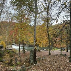
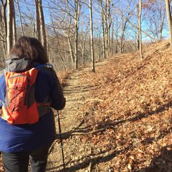
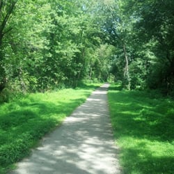
Easy bike ride along the Monongahela River. My friend and I started at the well-marked Clarksville trailhead near the Greene Cove Yacht Club and made our way towards Rices Landing. For the time being the trail is not very long (about 11 miles roundtrip) but I read that there are plans to add another 9 miles to the trail which would make it worth driving from Pittsburgh to enjoy on bike. We unfortunately got caught in the rain and a couple down trees meant we turned around about two thirds of the way. Nevertheless the trail had little elevation and Rices Landing was a nice place to stop (there are historic buildings in town, a gazebo and a small park where you can sit along the river). We passed several picnic benches along the trail where one could sit and take in the lovely view. There was also a portajohn at the Rices Landing trailhead parking. Weather permitting, this would be a lovely hiking/walking trail. I'll be back with my bike in better weather once the trail is extended. read more

8 years ago
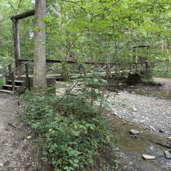
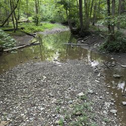
I finally got back to the Greene River Trail. We parked in the trail parking lot in Rice's Landing, which is approx. the half-way point of the trail. There is a port-a-john and a soda machine (the only ones along the trail) here at the parking lot. The trail now runs for 5.2 miles (not the ten miles as I had written about in my earlier review), along the Monongahela River, so we rode down river first. This is the nicer part of the trail, and corresponds with my original review below. We rode down to the marina, where the trail mile markers count down to mile 1. Also in my earlier review I mentioned that you could go through a grassy area towards an old train bridge, but that area has become overgrown, so I wasn't able to view the old bridge this time. We turned around, and rode back to Rice's Landing, stopping at the very nice restrooms near the entrance to Pumpkin Run Park, and we also stopped to see the historical foundry built in 1900, which is just a little bit down the road past the bathrooms. After checking out the foundry, we got back on the trail, and rode to the end, and this end of the trail is not quite as scenic, and it has some industrial views, but it got nice again towards the end with views of the river. After turning around, we rode back to Rice's Landing, and checked out a few more historical sights (most of them have history markers on them) including the old bank building, and the two old lockhouses. Even though the trail is short, it is worth checking out. read more


) . . . - Hiking Near Me - Rices Landing, Pennsylvania")


More info about Greene River Trail


Greene River Trail - hiking - Updated June 2026
Best of Rices Landing
People found Greene River Trail by searching for…
Parks in Rices Landing, Pennsylvania
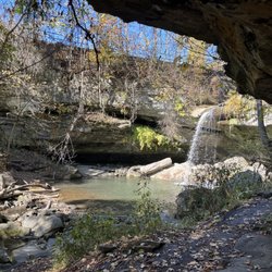
Hiking Trails With Waterfalls in Rices Landing, Pennsylvania
Marinas in Rices Landing, Pennsylvania
Things to Do in Rices Landing, Pennsylvania
Fishing Spots in Rices Landing, Pennsylvania
Beautiful Views in Rices Landing, Pennsylvania
Scenic Views in Rices Landing, Pennsylvania
Off Road Trails in Rices Landing, Pennsylvania
Walking Trails in Rices Landing, Pennsylvania
Scenic Overlook in Rices Landing, Pennsylvania
Secret Spots in Rices Landing, Pennsylvania
Boating in Rices Landing, Pennsylvania
Picnic Spots in Rices Landing, Pennsylvania
Picnic Areas in Rices Landing, Pennsylvania
Waterfalls in Rices Landing, Pennsylvania
Swimming Lakes in Rices Landing, Pennsylvania
Running Trails in Rices Landing, Pennsylvania
Playgrounds in Rices Landing, Pennsylvania
Bait and Tackle Shop in Rices Landing, Pennsylvania
Sunrise View in Rices Landing, Pennsylvania
Bike Paths in Rices Landing, Pennsylvania
Views in Rices Landing, Pennsylvania
Trending Searches in Rices Landing, PA
Browse Articles
Browse Nearby
BEST of Rices Landing, Pennsylvania Things to Do near Greene River Trail
BEST of Rices Landing, Pennsylvania Restaurants near Greene River Trail
BEST of Rices Landing, Pennsylvania Coffee near Greene River Trail
BEST of Rices Landing, Pennsylvania Parks near Greene River Trail
BEST of Rices Landing, Pennsylvania Fishing near Greene River Trail
BEST of Rices Landing, Pennsylvania Campgrounds near Greene River Trail
BEST of Rices Landing, Pennsylvania Breakfast near Greene River Trail
Browse Brands
Related Searches in Rices Landing, PA
Affordable Bike Repair Services in Rices Landing, Pennsylvania
Affordable Bike Tune Up Services in Rices Landing, Pennsylvania
Affordable Canoe Rental Options in Rices Landing, Pennsylvania
Affordable Fishing Rental Services in Rices Landing, Pennsylvania
Best Boat Launch Spots in Rices Landing, Pennsylvania
Best Dog Hiking Trails Around Rices Landing, Pennsylvania
Best Fishing Locations and Guides in Rices Landing, Pennsylvania
Best Lookout Points to Visit in Rices Landing, Pennsylvania
Best Nature Trails for Hiking in Rices Landing, Pennsylvania
Best Places for Stunning Views in Rices Landing, Pennsylvania
Best Spots for Star Gazing in Rices Landing, Pennsylvania
Best Waterfalls and Swimming Holes in Rices Landing, Pennsylvania
Book Private Boat Charters for Trips in Rices Landing, Pennsylvania
Check Out Off Road Trails in Rices Landing, Pennsylvania
Discover Dog Friendly Beaches Near Rices Landing, Pennsylvania
Discover Dog Friendly Trails to Explore in Rices Landing, Pennsylvania
Discover Popular Bike Trails in Rices Landing, Pennsylvania
Discover Popular Photo Spots in Rices Landing, Pennsylvania
Discover Scenic Creeks to Explore in Rices Landing, Pennsylvania
Discover Scenic Mountain Bike Trails Near Rices Landing, Pennsylvania
Discover Stunning Skyline View Spots in Rices Landing, Pennsylvania
Discover Top Boat Tours in Rices Landing, Pennsylvania for All Ages
Discover Top Nature Parks to Visit in Rices Landing, Pennsylvania
Discover a Hiking Trail in Rices Landing, Pennsylvania
Discover the Best Fishing Lake in Rices Landing, Pennsylvania
Discover the Best Night Hike Trails in Rices Landing, Pennsylvania
Discover the Best Sunset Cruise Tours in Rices Landing, Pennsylvania
Dog-Friendly Hikes With Dogs in Rices Landing, Pennsylvania
Effective Stairs Workout Spots in Rices Landing, Pennsylvania
Enjoy Exciting Mountain Biking Adventures in Rices Landing, Pennsylvania
Enjoy Fishing With Kids in Rices Landing, Pennsylvania Safely
Enjoy Hiking Adventures in Rices Landing, Pennsylvania
Enjoy Sailing Adventures in Rices Landing, Pennsylvania
Enjoy Scenic Night View Experiences in Rices Landing, Pennsylvania
Enjoy a Relaxing Paddle Boat Ride in Rices Landing, Pennsylvania
Enjoy a Scenic Boat Ride in Rices Landing, Pennsylvania
Enjoy the Best Night View Spots in Rices Landing, Pennsylvania
Enjoy the Best Walking Trails in Rices Landing, Pennsylvania
Experience Stunning Sunset Views in Rices Landing, Pennsylvania
Explore BMX Bike Shops Near Rices Landing, Pennsylvania
Explore Beautiful Parks and Green Spaces in Rices Landing, Pennsylvania
Explore Easy Hikes Perfect for All in Rices Landing, Pennsylvania
Explore Jet Skis for Sale or Rent in Rices Landing, Pennsylvania
Explore Nature Spots Around Rices Landing, Pennsylvania
Explore Popular Campgrounds Near Rices Landing, Pennsylvania
Explore Popular Scenic Overlook Points in Rices Landing, Pennsylvania
Explore Popular View Points Around Rices Landing, Pennsylvania
Explore Secret Spots Worth Visiting in Rices Landing, Pennsylvania
Explore the Best Swimming Holes Around Rices Landing, Pennsylvania