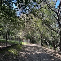
Greenbelt Trails Photos


You might also consider
More like Greenbelt Trails
Recommended Reviews - Greenbelt Trails
Start your review...

Reviews With Photos

My aunt had this ancient Japanese wisdom... she advised against hiking.... On the surface a hike in a park seems like a a great idea. Fresh air, exercise... being one with nature... when you dig a bit deeper - this is something that should probably be avoided. Dangerous cliffs, broken ankles - vicious mountain lions with rabies.... Deers and ticks and Lyme disease. Too much sun and skin cancer... need I say more? She also gave advice like 'don't be cheap - you pay twice.' So... what to do for recreation? Well, she advised going to a cool, comfortable air conditioned casino. Nothing bad ever happens there she said. Maybe you lose a few bucks but other than that... well, nothing to worry about. So if you must... bring a friend and put some tea tree oil on your legs - or better yet just wear a flea collar. Sun block - yeah... that should do it.

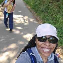
The map on Yelp is completely wrong! It will take you to a residential area high in the mountains in the middle of nowhere. The same goes for Google maps! It is quite embarrassing to say, but as a longtime Hayward resident, I can't believe I had not heard of this place sooner, and also had so much trouble finding it. I guess that shows what a true secret local gem it really is. Anyhow, all you need to do is look for the Hayward Plunge, and that is where the trail starts. Plenty of parking is available right around the tennis courts, even during the lockdown, when all of the other Bay Area trails are seemingly jam packed. There is actually a halfway point on either Campus Dr. or Oakes Dr. nestled into the hills (the trail is bisected by a pair of somewhat treacherous streets) where you can also park, but if it's your first time, you are better off starting at the bottom. The lower half is much more interesting anyhow. While I wouldn't say that the Greenbelt is the most challenging nor scenic hike in the Bay, it is certainly an under the radar escape from the hustle and bustle, a mere footsteps away from civilization. You basically go from a busy major thoroughfare to a wooded forest in a matter of minutes. As alluded to above, the trail is really divided into two parts. The bottom, more interesting section is an out and back, while the upper is more of a loop with a shorter out and back where it begins and ends from the street. The entire hike is about 6.3 miles, and you should be able to complete it in under three hours. The lower part consists of three creek crossings, a small waterfall, and best of all, for urban art fans, a sick graffiti wall. The top section is more wooded, and truly feels like you've been transported to some rural area out in the wilderness. One huge benefit is that during warm days, it is still nice and cool, since you're not exposed to the elements like you would be at Garin Park or Mission Peak. In closing, if you are in and around the Lower East Bay, and seeking a quick getaway to collect your thoughts without having to go very far, the Greenbelt is just your ticket. Since it is somewhat hidden, and not as well known as many of the other regional parks, your serenity shall not be disturbed by those who choose to disobey social distancing orders.

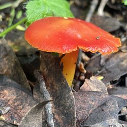
Who would have thought that such a gorgeous set of hiking trails would be tucked behind a random park off of Mission Blvd of all places?! That's the Bay Area for you! All kinds of beautiful gems just waiting to be explored. Hiked roughly 7 miles here with my hiking group a few months ago, and it was such a pretty hike! There are three trails that you can connect to make a loop. You can actually access the trails from several different access points since there are parts of the trails that go behind the neighborhood in the Hayward hills, but we started at Memorial Park which is right next to the Hayward Plunge. Some parts were a bit muddy after some recent rains, but nothing too difficult to navigate. The trail that starts from Memorial Park is called the "Wally Wickander Memorial Trail", and this will be the same trail that you'll take back if you are planning to do the full 7 mile loop. From the park it doesn't look like much is back there, but damn was it a shocker. The pathway features stunning Redwoods, Eucalyptus trees and a pretty little waterfall. There's also a small creek that you'll have to cross, but it's an easy pass through. This part of the trail is pretty mild and is mostly flat with minimal inclines. We connected to the Ward Creek Trail next. You'll have to cross the street in a residential neighborhood and cross over a small bridge to get to this trail. This part of the trail inclines almost the entire time, but the incline is gentle. It's still a great workout. There are also mile markers in this trail and lots of beautiful vegetation. There's one short part of the trail where you'll basically be hiking behind backyards. We heard a few dogs barking when we hiked by. My absolute favorite trail during the hike was the last trail that we connected to which is called the East Avenue Trail. It honestly almost made me forget that I was in Hayward. The most amazing old growth Redwood trees line this beautiful trail, and you'll have some stunning views of the Hayward hills at the beginning. This trail descends back down into the forest, so you'll have the most picturesque views here. The pretty ferns, the bright yellow poisonous mushrooms; all of it is such a wonderful sight to see. There's also another park/recreation site that you'll pass through. Once you hit the end of the East Avenue Trail, you can head back down the Wally Wickander Trail which will take you back to Memorial Park. Talk about a hidden gem! These trails are really stunning and such a nice surprise. Would love to come back after the quarantine is over. But this is an excellent place to hike if you're a local. Would highly recommend!


Another awesome hidden trail ...at Memorial Park! I would never thought there was a trail here but found it on TrailApp. Best part about it was it was all pretty shaded and free parking! It's a great on warm days! Located close to downtown Hayward on Mission Blvd. You should park close to tennis courts as the Greenbelt Trail is close it it. Look for entrance name. I would consider this trail moderate but long (@7+ miles) so make sure to bring plenty of water and snacks. The trail sign says it's a hard trail though. There are parts were the trails go steep up or down but not too long. You will go over a thousand feet up the hill and was a loop. Trails do pass by private road homes. Make sure to look out for the continued trail. You will pass thru creeks so I would wear waterproof hiking shoes. It took me about 2 hours and 45 minutes as some parts are unmarked or we took time to take pictures. The trail is 95% shaded with trees so great on warm days. The creeks were low but I am sure it would be plenty by winter. There was one small waterfall I saw. It's moderately Traffic with people who bring their dogs but we barely saw any poops so at least the trails were maintained by everyone who passes. I would recommend this trail! [88/100]

This is honestly the most unique, hidden gems of East Bay. One of my all time favorite hiking trails, plenty of shade, not crowded at all. There are so amazing graffiti art. It's a relatively easy trail, plenty of parking in front of Hayward Plunge. - Highly recommend! It's a bit hidden tho.

After touring the Japanese Gardens, our friend took us to the Greenbelt Trails for a hike. After about 1.5 mile walk, we walked passed the Hayward Plunge / Memorial Park. There are three trails in the Greenbelt and from our entry point, we were on the Wally Wicklander Memorial Trail. The trail path was groomed and well maintained. Since it was a sunny and warm day, it was nice being on this trail as it was shaded by trees and there was a creek that runs next it. Given our time constraints, we couldn't continue onto to the other two trails and we headed back. Being on this trail, you would never think that downtown was only about five blocks away. This is nice Hayward gem, which I'm glad I was able to hike and explore. I'll be back again to hike the other trails.

I just moved to Hayward a few weeks ago and I'm in need of a place to take my dog Bane out. This trail/park is great! There is plenty of shade through the trails because Bane is a long-haired German Shepherd. There were a lot of picnic tables there and trash cans so please don't litter! It's a nice spot to check out with friends or animals. I didn't go too far in today because I wasn't expecting to walk up hills with my steel toe work boots and pants but I got in about over a mile or so. Highly recommend this area. A little difficult to find at first but just take Campus Dr. and you will see a greenbelt sign then make the next available right to park residentially. Have fun! Bring water!

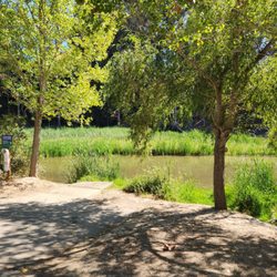
What a beautiful, hidden dog-friendly gem! There are several trails to choose from, which snake down into the canyon and along the creek. Most of the trails are shaded by towering oaks and eucalyptus trees, and the trails are lined with vibrant green plants (even in summer). There are a couple steep trails, but most are pretty mild. Lots of water fountains and garbage cans are spread throughout the trail, and it's very clean. During our two hour Sunday afternoon hike, we only ran into one other person. We started our hike at the parking lot for East Avenue Park, at the top of East Avenue. There are a couple trail entrances within the park, but the easiest to find is visible at the end of the parking lot.

Yelp's location did not help at all! It was a huge ordeal but we made the Greenbelt trail. We went to the Hayward library to ask where the trail was because it seem to be around the vicinity. They pointed us to The Plunge, behind it was a park where there were cobble stone stairs leading to the Girl Scout's cabin and a grassy little hill. There was a man whom look as if he knew where the trail was... he did! However, he notified us that THE TRAIL WAS CLOSED due to trees blocking the path. He was a kind man with 2 recommendations: follow him but there will be trees to hurdle or go up Campus drive to try our luck. I chose Campus drive! I Google Map Campus drive not knowing the exact location which was a bad idea because we ended up driving pass Campus drive and parking at a CalState East Bay parking lot. I finally find GREENBELT trail exploring Google Maps. I drive back to the direction of Campus drive. I parked at this deaf community facility. We walked down a slope with hardly any sidewalk which was scary because cars were speeding down. We finally see the trail and they posted a sign saying that the trail is closed due to landslides! Long story short drive up Campus drive the trail is a little pass Woodland Estate and the same side as Woodland Estate. It's a nice hike!

The only bad thing about this trail it's that it was hard to find, but there's 3 different trails in this location. We did the shortest one that was 3 miles, there and back all together. It leads to a park which was perfect because it was our kids first time hiking so it was pretty cool. There are a few steep hills but overall a good starting trail.

I take my best dog in the world to this party all the time. You can see that this "bitch" loves to play in the park. She loves the trails. She likes how it's never 2 busy with people. They have trails for all types of people, it's a pretty easy hike and it's really nice to see all the tree's and mother nature showing you how pretty she can be. I always make sure to take poop bags so you guys won't ever step in my dogs poop. You are welcome, whenever you hike here and it's poop free. You can thank me with a like :)


Nicely shaded. Just wish we knew where the trail starts. A yelper helped by saying the cross street of campus and oak. We parked all the way up the hill where the houses were. That was the toughest. The trail was nice and flat or manageable. Shaded. If no shade, super sunny and hot. You can hear the tiny stream. Picnic tables to eat and sit. I took pictures of map. They even have markers on how far you've walked. Next time we will start at the East Ave Park. Hayward has such a cool community. read more

1 year ago
What a hidden gem! Came here per recommendation from a fellow Yelper when looking for a less crowded hiking trail. From start to finish, the hike ends up being 6.3 miles long. You can also start at the intersection of Campus and Oakes Dr and that will take you directly to the start of the loop and make the hike a little shorter. Note: The Yelp map is incorrect. Use the AllTrails map or search for "Hayward Memorial Park" for the starting point if you plan on doing all three Greenbelt Trails (Wally Wickander Memorial Trail, East Avenue Trail, Ward Creek Rd. Trail). The trail has plenty of shade with a difficulty of easy to moderate at most. Went on a weekday afternoon and I only ran into two other persons the whole time. The beauty of this place is that you feel immersed in nature even when you're just a hop skip away from civilization and residential area. My only gripe was that there was so many bugs flying about! Ended up wearing my mask a good portion of the time to avoid swallowing any. Wally Wickander Memorial Trail connects Hayward Memorial Park to Campus Drive. There was a lot of graffiti on the rock faces that I thought actually added to the experience, but I wasn't a fan of all the trash (darn hooligans) on the ground. Respect nature and keep the parks clean, peoples! Overall, if you're looking to get away from the crowds, this is definitely a local favorite. read more


My aunt had this ancient Japanese wisdom... she advised against hiking.... On the surface a hike in a park seems like a a great idea. Fresh air, exercise... being one with nature... when you dig a bit deeper - this is something that should probably be avoided. Dangerous cliffs, broken ankles - vicious mountain lions with rabies.... Deers and ticks and Lyme disease. Too much sun and skin cancer... need I say more? She also gave advice like 'don't be cheap - you pay twice.' So... what to do for recreation? Well, she advised going to a cool, comfortable air conditioned casino. Nothing bad ever happens there she said. Maybe you lose a few bucks but other than that... well, nothing to worry about. So if you must... bring a friend and put some tea tree oil on your legs - or better yet just wear a flea collar. Sun block - yeah... that should do it. read more


The map on Yelp is completely wrong! It will take you to a residential area high in the mountains in the middle of nowhere. The same goes for Google maps! It is quite embarrassing to say, but as a longtime Hayward resident, I can't believe I had not heard of this place sooner, and also had so much trouble finding it. I guess that shows what a true secret local gem it really is. Anyhow, all you need to do is look for the Hayward Plunge, and that is where the trail starts. Plenty of parking is available right around the tennis courts, even during the lockdown, when all of the other Bay Area trails are seemingly jam packed. There is actually a halfway point on either Campus Dr. or Oakes Dr. nestled into the hills (the trail is bisected by a pair of somewhat treacherous streets) where you can also park, but if it's your first time, you are better off starting at the bottom. The lower half is much more interesting anyhow. While I wouldn't say that the Greenbelt is the most challenging nor scenic hike in the Bay, it is certainly an under the radar escape from the hustle and bustle, a mere footsteps away from civilization. You basically go from a busy major thoroughfare to a wooded forest in a matter of minutes. As alluded to above, the trail is really divided into two parts. The bottom, more interesting section is an out and back, while the upper is more of a loop with a shorter out and back where it begins and ends from the street. The entire hike is about 6.3 miles, and you should be able to complete it in under three hours. The lower part consists of three creek crossings, a small waterfall, and best of all, for urban art fans, a sick graffiti wall. The top section is more wooded, and truly feels like you've been transported to some rural area out in the wilderness. One huge benefit is that during warm days, it is still nice and cool, since you're not exposed to the elements like you would be at Garin Park or Mission Peak. In closing, if you are in and around the Lower East Bay, and seeking a quick getaway to collect your thoughts without having to go very far, the Greenbelt is just your ticket. Since it is somewhat hidden, and not as well known as many of the other regional parks, your serenity shall not be disturbed by those who choose to disobey social distancing orders. read more


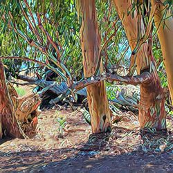
Who would have thought that such a gorgeous set of hiking trails would be tucked behind a random park off of Mission Blvd of all places?! That's the Bay Area for you! All kinds of beautiful gems just waiting to be explored. Hiked roughly 7 miles here with my hiking group a few months ago, and it was such a pretty hike! There are three trails that you can connect to make a loop. You can actually access the trails from several different access points since there are parts of the trails that go behind the neighborhood in the Hayward hills, but we started at Memorial Park which is right next to the Hayward Plunge. Some parts were a bit muddy after some recent rains, but nothing too difficult to navigate. The trail that starts from Memorial Park is called the "Wally Wickander Memorial Trail", and this will be the same trail that you'll take back if you are planning to do the full 7 mile loop. From the park it doesn't look like much is back there, but damn was it a shocker. The pathway features stunning Redwoods, Eucalyptus trees and a pretty little waterfall. There's also a small creek that you'll have to cross, but it's an easy pass through. This part of the trail is pretty mild and is mostly flat with minimal inclines. We connected to the Ward Creek Trail next. You'll have to cross the street in a residential neighborhood and cross over a small bridge to get to this trail. This part of the trail inclines almost the entire time, but the incline is gentle. It's still a great workout. There are also mile markers in this trail and lots of beautiful vegetation. There's one short part of the trail where you'll basically be hiking behind backyards. We heard a few dogs barking when we hiked by. My absolute favorite trail during the hike was the last trail that we connected to which is called the East Avenue Trail. It honestly almost made me forget that I was in Hayward. The most amazing old growth Redwood trees line this beautiful trail, and you'll have some stunning views of the Hayward hills at the beginning. This trail descends back down into the forest, so you'll have the most picturesque views here. The pretty ferns, the bright yellow poisonous mushrooms; all of it is such a wonderful sight to see. There's also another park/recreation site that you'll pass through. Once you hit the end of the East Avenue Trail, you can head back down the Wally Wickander Trail which will take you back to Memorial Park. Talk about a hidden gem! These trails are really stunning and such a nice surprise. Would love to come back after the quarantine is over. But this is an excellent place to hike if you're a local. Would highly recommend! read more


3 years ago

Another awesome hidden trail ...at Memorial Park! I would never thought there was a trail here but found it on TrailApp. Best part about it was it was all pretty shaded and free parking! It's a great on warm days! Located close to downtown Hayward on Mission Blvd. You should park close to tennis courts as the Greenbelt Trail is close it it. Look for entrance name. I would consider this trail moderate but long (@7+ miles) so make sure to bring plenty of water and snacks. The trail sign says it's a hard trail though. There are parts were the trails go steep up or down but not too long. You will go over a thousand feet up the hill and was a loop. Trails do pass by private road homes. Make sure to look out for the continued trail. You will pass thru creeks so I would wear waterproof hiking shoes. It took me about 2 hours and 45 minutes as some parts are unmarked or we took time to take pictures. The trail is 95% shaded with trees so great on warm days. The creeks were low but I am sure it would be plenty by winter. There was one small waterfall I saw. It's moderately Traffic with people who bring their dogs but we barely saw any poops so at least the trails were maintained by everyone who passes. I would recommend this trail! [88/100] read more


This is honestly the most unique, hidden gems of East Bay. One of my all time favorite hiking trails, plenty of shade, not crowded at all. There are so amazing graffiti art. It's a relatively easy trail, plenty of parking in front of Hayward Plunge. - Highly recommend! It's a bit hidden tho. read more


After touring the Japanese Gardens, our friend took us to the Greenbelt Trails for a hike. After about 1.5 mile walk, we walked passed the Hayward Plunge / Memorial Park. There are three trails in the Greenbelt and from our entry point, we were on the Wally Wicklander Memorial Trail. The trail path was groomed and well maintained. Since it was a sunny and warm day, it was nice being on this trail as it was shaded by trees and there was a creek that runs next it. Given our time constraints, we couldn't continue onto to the other two trails and we headed back. Being on this trail, you would never think that downtown was only about five blocks away. This is nice Hayward gem, which I'm glad I was able to hike and explore. I'll be back again to hike the other trails. read more


6 years ago
I just moved to Hayward a few weeks ago and I'm in need of a place to take my dog Bane out. This trail/park is great! There is plenty of shade through the trails because Bane is a long-haired German Shepherd. There were a lot of picnic tables there and trash cans so please don't litter! It's a nice spot to check out with friends or animals. I didn't go too far in today because I wasn't expecting to walk up hills with my steel toe work boots and pants but I got in about over a mile or so. Highly recommend this area. A little difficult to find at first but just take Campus Dr. and you will see a greenbelt sign then make the next available right to park residentially. Have fun! Bring water! read more


7 years ago
9 years ago
What a beautiful, hidden dog-friendly gem! There are several trails to choose from, which snake down into the canyon and along the creek. Most of the trails are shaded by towering oaks and eucalyptus trees, and the trails are lined with vibrant green plants (even in summer). There are a couple steep trails, but most are pretty mild. Lots of water fountains and garbage cans are spread throughout the trail, and it's very clean. During our two hour Sunday afternoon hike, we only ran into one other person. We started our hike at the parking lot for East Avenue Park, at the top of East Avenue. There are a couple trail entrances within the park, but the easiest to find is visible at the end of the parking lot. read more


9 years ago
Yelp's location did not help at all! It was a huge ordeal but we made the Greenbelt trail. We went to the Hayward library to ask where the trail was because it seem to be around the vicinity. They pointed us to The Plunge, behind it was a park where there were cobble stone stairs leading to the Girl Scout's cabin and a grassy little hill. There was a man whom look as if he knew where the trail was... he did! However, he notified us that THE TRAIL WAS CLOSED due to trees blocking the path. He was a kind man with 2 recommendations: follow him but there will be trees to hurdle or go up Campus drive to try our luck. I chose Campus drive! I Google Map Campus drive not knowing the exact location which was a bad idea because we ended up driving pass Campus drive and parking at a CalState East Bay parking lot. I finally find GREENBELT trail exploring Google Maps. I drive back to the direction of Campus drive. I parked at this deaf community facility. We walked down a slope with hardly any sidewalk which was scary because cars were speeding down. We finally see the trail and they posted a sign saying that the trail is closed due to landslides! Long story short drive up Campus drive the trail is a little pass Woodland Estate and the same side as Woodland Estate. It's a nice hike! read more

8 years ago
8 years ago
The only bad thing about this trail it's that it was hard to find, but there's 3 different trails in this location. We did the shortest one that was 3 miles, there and back all together. It leads to a park which was perfect because it was our kids first time hiking so it was pretty cool. There are a few steep hills but overall a good starting trail. read more

11 years ago
I take my best dog in the world to this party all the time. You can see that this "bitch" loves to play in the park. She loves the trails. She likes how it's never 2 busy with people. They have trails for all types of people, it's a pretty easy hike and it's really nice to see all the tree's and mother nature showing you how pretty she can be. I always make sure to take poop bags so you guys won't ever step in my dogs poop. You are welcome, whenever you hike here and it's poop free. You can thank me with a like :) read more

13 years ago

8 years ago
12 years ago
Its quiet, secluded and has a great view. Great for biking, running, or just going for a stroll. read more

10 years ago
This place is just beautiful! Perfect for a nice relaxing hike! The scenery is great for photography. It's nice and cool in the hot summer days! The creek is so nice to see after a nice rainy day! There are a few places with graffiti, which would usually bother me but it actually adds something special in a fun way. Seriously, this trial is now one of my favorites! I noticed that a lot of doggie walkers do let their dogs on the loose (not leashed)so, just keep that in mind. read more


11 years ago
I live on Hayward since 1986 and this is my first time here..I have to say I love it! It's definitely a nice little trail/hiking place near by. Many hidden treasure in Hayward I had no idea but embracing it for sure! Definitely bring a jacket in the cold weather as the woody nature keep it quite cold...perfect trail probably on a hot day. Would totally do this again soon! read more


8 years ago
12 years ago
7 years ago
8 years ago
6 years ago
9 years ago
11 years ago
11 years ago
10 years ago
10 years ago
More info about Greenbelt Trails
Hayward, CA 94542
Directions
Hours
Outdoor Amenities
Ask the Community - Greenbelt Trails
Is the greenbelt trail currently open? According to a review on All trails a month ago, it was closed.
It is still technically closed as of 18 June 2023. I'm not sure how the trails look on the other side of Campus Drive, but starting at the plunge, you can go in a little bit but are then confronted by fallen trees across the path.
What is the actual address?
24241 mission blvd/CA-238, Hayward, CA 94544 This trail head is located behind the plunge at the… Read more
Is this hiking open during the shelter in place?
I think it was, this doesn't apply anymore
Review Highlights - Greenbelt Trails
You might also consider


Why does Yelp recommend reviews?
2 reviews that are not currently recommended
The reviews below are not factored into the business's overall star rating.
3 years ago
12 years ago
Greenbelt Trails - hiking - Updated July 2026
Best of Hayward
People found Greenbelt Trails by searching for…
Trending Searches in Hayward, CA
Black Owned Nail Salons near Greenbelt Trails
Boat Rental near Greenbelt Trails
Cliff Jumping near Greenbelt Trails
Day Trips near Greenbelt Trails
Dog Swimming near Greenbelt Trails
Jet Ski Rental near Greenbelt Trails
Kayak Rental near Greenbelt Trails
Lakes & Ponds near Greenbelt Trails
Off Road Trails near Greenbelt Trails
Outdoor Activities near Greenbelt Trails
Picnic Spots near Greenbelt Trails
Places To Walk Around near Greenbelt Trails
Public Pools near Greenbelt Trails
Public Shower near Greenbelt Trails
River Swimming near Greenbelt Trails
River Tubing near Greenbelt Trails
Rock Quarry near Greenbelt Trails
Running Trails near Greenbelt Trails
Scenic Night View near Greenbelt Trails
Scenic Overlook near Greenbelt Trails
Soccer Store near Greenbelt Trails
Splash Pad near Greenbelt Trails
Sunrise View near Greenbelt Trails
Swimming Holes near Greenbelt Trails
Swimming Lakes near Greenbelt Trails
U Pick Farms near Greenbelt Trails
Watch Sunset near Greenbelt Trails
Browse Articles
Browse Nearby
BEST of Hayward, California Coffee near Greenbelt Trails
BEST of Hayward, California Things to Do near Greenbelt Trails
BEST of Hayward, California Restaurants near Greenbelt Trails
BEST of Hayward, California Walking Trails near Greenbelt Trails
BEST of Hayward, California Parks near Greenbelt Trails
Browse Brands
Related Searches in Hayward, CA
Affordable Kayak Rental Services in Hayward, California
Best Fishing Locations and Guides in Hayward, California
Best Nature Trails for Hiking in Hayward, California
Best Places for Horseback Riding in Hayward, California
Best Waterfalls and Swimming Holes in Hayward, California
Check Out Off Road Trails in Hayward, California
Discover Dog Friendly Trails to Explore in Hayward, California
Discover Kid Friendly Hiking Trails in Hayward, California
Discover Scenic Hiking Trails in Hayward, California
Discover Scenic Mountain Bike Trails Near Hayward, California
Discover Scenic Waterfall Spots in Hayward, California
Discover Walking Parks in Hayward, California Near You
Discover a Hiking Trail in Hayward, California
Discover the Best Night Hike Trails in Hayward, California
Dog-Friendly Hikes With Dogs in Hayward, California
Enjoy Camping Adventures Around Hayward, California
Enjoy Exciting Mountain Biking Adventures in Hayward, California
Enjoy Kayaking Adventures in Hayward, California
Enjoy Tent Camping Spots Around Hayward, California
Enjoy a Beautiful Waterfall Hike in Hayward, California
Enjoy a Peaceful Nature Walk in Hayward, California
Enjoy the Best Picnic Spots and Ideas in Hayward, California
Enjoy the Best Walking Path in Hayward, California
Enjoy the Best Walking Trails in Hayward, California
Explore Beautiful Parks and Green Spaces in Hayward, California
Explore Easy Hikes Perfect for All in Hayward, California
Explore Fun Activities to Do in Hayward, California
Explore Popular Campgrounds Near Hayward, California
Explore the Best Beach Spots in Hayward, California
Explore the Best Trail Options in Hayward, California
Family Friendly Hiking With Kids in Hayward, California
Find Beautiful Views in Hayward, California
Find the Best Parks for Picnics in Hayward, California
Find the Best Scenic View Locations in Hayward, California
Great Places to Walk in Hayward, California
Hike the Popular Waterfall Trail in Hayward, California
Hiking Trails With Waterfalls in Hayward, California
Off Leash Dog Hiking Trails in Hayward, California
Plan a Scenic Drive Route Near Hayward, California
Popular Outdoor Activities to Try in Hayward, California
Popular Picnic Spots to Visit in Hayward, California
Safe River Swimming Areas in Hayward, California
Safe and Fun Parks for Kids in Hayward, California
Top Climbing Spots and Gyms in Hayward, California
Top Paddleboarding Activities in Hayward, California
Top Running Trails to Explore in Hayward, California
Top Swimming Lakes to Enjoy in Hayward, California
Top Swimming Spots and Pools in Hayward, California