Cancel

    Open app

    Search

    Garrett State Forest

    5.0 (1 review)

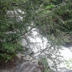
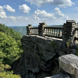
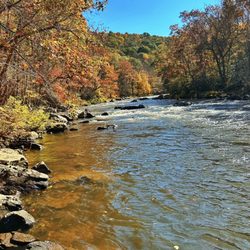
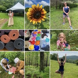
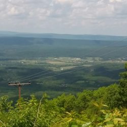
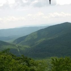
    Garrett State Forest Photos

    More like Garrett State Forest

    Recommended Reviews - Garrett State Forest

    Your trust is our priority, so businesses can't pay to alter or remove their reviews. Learn more about reviews.
    Yelp app icon
    Browse more easily on the app
    Review Feed Illustration

    14 years ago

    Helpful 0
    Thanks 0
    Love this 1
    Oh no 0

    Verify this business for free

    Get access to customer & competitor insights.

    Verify this business

    All Earth Eco Tours - Time for You (and your child too!) Tuesdays

    All Earth Eco Tours

    4.3(6 reviews)
    28.5 km

    My family and I recently went on a kayaking tour with All Earth Eco Tours, and it was an incredible…read moreexperience from start to finish. Our guide, Oliver, was knowledgeable, patient, and passionate about the environment and the Savage River Reservoir. He made us feel relaxed and welcomed, including my daughter's cutout of "Flat Stanley", who came along for the adventure. Oliver shared numerous insights about the history, wildlife, and ecosystem of the reservoir. The setting itself is absolutely stunning--peaceful, remote, and surrounded by pristine forest. The calm, glassy water made for an easy paddle, perfect for all skill levels, especially for our 7 yo daughter, who joined in a tandem kyack. We saw herons, turtles, and even a hawk soaring overhead. We heard woodpeckers also. The local eagles were not active when we went out, but that didn't lessen the experience. Oliver made sure everyone felt comfortable and safe, as we paddled out and back. This tour is the perfect way to unwind. I can't recommend it highly enough--no matter your skill level, kayaking the Savage River Reservoir with All Earth Eco Tours is a must-do when visiting the Deep Creek Lake area. Thank you, Oliver, for such a memorable day!

    So unhappy with this business. We called and tried to schedule a tour over the weekend. They…read morecouldn't be bothered to call us back. If they were full, they could have just said that rather than ignoring us.

    Photos
    All Earth Eco Tours - Book a private group Yoga to You session today!

    Book a private group Yoga to You session today!

    All Earth Eco Tours - Hooray for summer! Now booking Yoga to You and all of our fantastic programs! Call today! 301-746-4083

    Hooray for summer! Now booking Yoga to You and all of our fantastic programs! Call today! 301-746-4083

    All Earth Eco Tours - Yoga to You. No socks or shoes required.

    See all

    Yoga to You. No socks or shoes required.

    Spruce Knob - Seneca Rocks National Recreation Area

    Spruce Knob - Seneca Rocks National Recreation Area

    4.6(33 reviews)
    68.3 km

    Seneca Rocks Trail. A number of years ago, my husband and I visited the educational Discovery…read moreCenter for the Seneca Rocks National Recreation Area, and got a great view of the Seneca Rocks from the parking lot. But, it was late in the day on a Sunday and we had a long drive ahead of us, so we decided not to attempt to hike up the trail, but we put it as yet another item on our bucket list. We returned to the area in Sept, 2025, specifically to attempt to do the hike. No concerns as to whether my husband would be able to do it, but I have to admit that I was apprehensive as to whether I could! The brochures say that it's 1.5 miles each way (up, and then back down) and you gain almost 850' in elevation. And, did I mention that I'm in my 60s, NOT a regular hiker, and with a medical condition that affects my balance? Nonetheless, my husband and I donned our hiking boots, put on some sunscreen, packed a picnic lunch, snacks, and water, and my hiking stick -- and we were on our way! The trail is wide and well-maintained and, as others have mentioned, has steep sections, especially in the switchbacks towards the top. It's a steady climb up, and my Fitbit registered some intense exercise, but my heart rate never reached its peak category. Given my balance issues, having my walking stick and an occasional hand from my husband, especially on the descent in steep areas with roots or stones, were helpful. I tried not to be discouraged by the two very fit runners who raced by us, recognizing that the majority of hikers and dogs on leash were panting at least to some degree! There are occasional benches, especially towards the bottom, and signs pointing out ecological features. There's an observation deck at the top, with gorgeous views of the valley below, as well as shaded benches to enjoy our picnic lunch. You can't see the rocks from the observation deck. However, some hikers scramble over some additional rocks for more views though signage warns that this can be dangerous. I'm happy to report that my husband and I both completed the hike, and we are now able to cross that item off of our joint bucket list. We celebrated our accomplishment by getting some ice cream at Yokum's, just down the street! Admission to the Seneca Rocks National Recreation Area and parking is free. Staff in the Discovery Center are exceptionally helpful. There are picnic tables and restrooms at the base, and the Seneca Shadows Campground is about a mile down the street.

    Literally a quick trip ( sadly), recommended by a friend, en route from Cass to Elkins…read more Absolutely beautiful and would have loved to have hiked this beauty. Hope to return one day ( Florida resident), preferably again in the fall to see the colors. Nature center sadly closed because of the government shut down.

    Photos
    Spruce Knob - Seneca Rocks National Recreation Area
    Spruce Knob - Seneca Rocks National Recreation Area - Another view of the top.

    Another view of the top.

    Spruce Knob - Seneca Rocks National Recreation Area

    See all

    Eagle Rock / Tuscarora Trail - WV to the west. Wardensville.

    Eagle Rock / Tuscarora Trail

    5.0(3 reviews)
    86.6 km

    Absolutely beautiful landscapes and views of the valley and ridge lines. The hike is a short…read moredistance (0.8 miles) to the view point, but the change in elevation makes it a great workout.

    - Update - *Several…read morepeople have advised me that the bird that tried to attack me is a Ruffled Grouse!* Apparently, they are well known in the area and confirmed to be aggressive and make strange noises! *Don't say you haven't been warned! :-) Saturday for the Memorial Weekend, I went to Wardensville WV to hike the Eagle Rock. AKA Tuscarora Trail. It's a simple 1 hour from my house. It's part of the Great North Mountain that acts as part of a natural border of WV and VA for some miles. The total miles of the Tuscarora Trail is 252 miles. It runs through PA/MD/WV and VA. It catches some of the Appalacian Trail at the Matthew's Arm Campground area. This trail was built as an alternative route for the Appalacian Trail due to the fear of the AT being shut down from development along the areas. The Tuscarora Trailhead for this location starts on the tippy top of The Great North Mtn on US48/VA55. At this location also you are in George Washington National Forest. You honestly can't miss it. 66w to 81s. Strasburg Exit to US48/VA55 follow for about 17 miles and you crest the mountain. There is a sign at the crest on the left near the wooods saying Tuscarora Trail. You can see it from the road. It slightly catches your eye but on the right side, you will see a big brown sign that says Entering Wardensville Cooperative Wildliffe Management Area. Park at the sign. Do not block the fire gates. I started out a little upset by the amount of hiker garbage on the o/s guardrail. Tons of Ice tea and water bottles littering the entire area. Not just a couple. It's like a ground of plastic bottles here. Also a bit worrisome was the constant gunshots. Over and Over until about the 1.5 mile stretch ends. I even saw Shot gun casings on the path, but I guess the sign did say Wildlife management Area. Geeze. The first mile was strenuous. There, I passed my first and only group of people I ever saw. They seemed to be teens chaperoned by 3 adults. They were catching their breath on the first mile. It was steep. Afterward, it leveled out and you could see you were walking the ridgeline of the mountain by looking o/s the trees to the mountain next door. Same height. From here it went from breathlessly uphill to muscle scortching downhill and leveling out.. over and over.. so overall there was give and take. A lot of the path became weedy and made my legs itchy. Some times it was almost knee length weeds. and the bugs. oh... the bugs. Don't stop for too long. I was breathing in a lot of bug protien on Saturday, let me tell you I had bugs for prelunch, lunch and snack! You could hear them around your head like a beehive. It was very much more wild than SNP. You could feel the wildness out here... I swear I am surprised I didn't see a bear. It was definately Bear Country! Speaking of this, let me also tell you what scared the living heck out of me up there. (Turns out after the scare I was laughing out loud all to myself but at the the time... I thought I was going to die) I heard some leaves russling... I slowed down and made a little noise...This...This... Turkey Bird Thing races out of the woods at full turkey bird speed and is coming right at me. It puffs up it's whole body and the tail spreads out like a Turkey but it's not big like a Turkey, more of a chicken size but fatter.... anyway this thing runs to me with his body puffed out and all I could do was walk backward and shout No over and over and over.. It's amazing I didn't fall down! That bird was litterally attacking me. I guess there was a nest along the patch in the woods and I was a bit close but OMG, If it were a bear, I'd be dead. That simple. Freaking Bird. OMG.... so it went off to the right and made this sound like a beaten dog.. wimpering..it was terrible. and When I started on my way, it followed me ! It was walking in the woods making that sickening noise for a good couple yards...That whole situation made me wonder about this dumb whistle I brought with me for safety. wow. wth is this whistle going to do! I forgot it was even in my hand! and that was a bird! lol. So later at a rock outcrop I almost sit on the one snake I saw the entire time. He was identical to the rock. Identical. I looked right at him and sat next to him. (?!?) The views were nice. A good change from SNP views. I'm glad I chose to hike this mountain this summer. There's so much more of it to hike and it even meets up with the Stairway to Heaven I did a couple weeks prior. I'm interested in exploring it a bit more. I may need to invest in a bigger whistle and perhaps a nice size knife as well. In the end, I was trying to outhike the storm on the way back to the car. I almost made it. But I was dripping wet once I turned the key! It was a great day and a great hike.

    Photos
    Eagle Rock / Tuscarora Trail - Trail grass can get high and is pretty itchy.

    Trail grass can get high and is pretty itchy.

    Eagle Rock / Tuscarora Trail - More scenery

    More scenery

    Eagle Rock / Tuscarora Trail - Scenery

    See all

    Scenery

    Woodstock Tower

    Woodstock Tower

    4.9(15 reviews)
    102.0 km

    Great place with great views!…read more Pop "Woodstock Tower" into Google Maps, and it will take you to the right spot (Apple Maps only took me to the trailhead a distance away). This will put you near a little overlook off the dirt road or if you keep going, a small gravel parking lot. Be prepared to drive on dirt and gravel roads for over a mile to get here; you are going the right way! This end of the trail has a clearly marked sign saying it is the Woodstock Tower. From either of those parking lots it's only about ¼ mile walk to get to the tower. The path varies from rocky to flat dirt. Loads of hickory nuts line the path. You could also come from the other end of the trail, which is over a mile away in the other direction. The climb up is steep but manageable (I'd recommend being more careful descending!) with metal steps. Considering she's still standing 90 years after her construction, I'd say the tower is stable. Hats off to the Civilian Conservation Corps for building this lasting landmark! The views from the top are great and worth the short walk and short climb. I met a local man at the top who shoots a lot of videos from up there. He did warn that sometimes there are black bears in the area; I never saw one my whole time, but just keep alert. It was a little cold on the mid-October day we were there and the top of the mountain did mean lots of cross wind, so dress appropriately. Unless you're weird about heights (apologies to my wife; thanks for walking out to it with us, Baby), this is a worthwhile visit. Definitely recommend!

    What a pleasant surprise! We drove up the mountain on Christmas Eve and simply enjoyed the views…read more Our goal of finding the tower wasn't easy being that my bf hadn't been up there since he was a kid. Nevertheless we found it :-) I was a bit apprehensive of climbing it at first but took baby steps lol. What a beautiful scenery once you reach the top. Great experience!

    Photos
    Woodstock Tower - It's quite a way down - don't fall!

    It's quite a way down - don't fall!

    Woodstock Tower
    Woodstock Tower - My wife's scared of heights, so she waited at the bottom for us.

    See all

    My wife's scared of heights, so she waited at the bottom for us.

    Garrett State Forest - hiking - Updated May 2026

    Loading...
    Loading...
    Loading...