Fort McClary
Fort McClary Photos


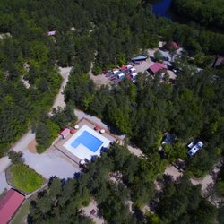
You might also consider
More like Fort McClary
Recommended Reviews - Fort McClary
Start your review...

Reviews With Photos - Fort McClary

This place has long been a favorite for my family since we were first there in 1999. On that first visit, we met an incredibly friendly and helpful park ranger (is that the right term?) named "Doc." Bright blue eyes and a generous smile, easy to talk with, and full of insider info of the area. He gave us tips on traveling through the area and what else to see. The kids, only small boys at the time, instantly adored him and Fort McClary (both the fort side and the picnic area across the street). For years we'd go back and visit and see the beloved Doc if he was around. Well, it's been a long time since we've seen our park friend. We've had many beach vacations where we've just stuck to Long Sands. We've visited Fort McClary a lot, though, often picking up a pizza at YHOP (York House of Pizza) and taking it to the fort grounds to eat & watch the boats chugging and sailing by. It's a wonderful spot for kids and adults who like to explore--there's the fort itself, some outbuildings, and even a "creepy" tunnel. Lots of grounds to run on, lots of big rocks to climb. There are picnic tables to rest at, and a very clean outdoor potty that always has enough tp and hand sanitizer. So back we went this trip (Aug. 2021), just my husband and me. It was as beautiful as ever. While we stayed out of the fort, we did walk the grounds and set up lunch at a picnic table under a tree. There was a marker for a trail I didn't remember being there before, but we didn't venture out. We watched the people and the boats, and used our binoculars to check out Fort Foster across the water. It was blissfully beautiful--sunny but in the 70s, with a little breeze and no heavy humidity/dew point. Even in the height of the summer season, there was parking and enough space to not feel at all like people were too close. Perfection. We came back another day to set up chairs and read at the picnic area across the street. We parked (there's handicapped parking in both halves of Fort McClary) and did a quick walk over to the frog pond. Didn't stay at the lookout long as there was a sign warning about a kind of fire ant they were having issues with this year. On our way to get the chairs from the car, we saw people emerge from a little path and realized we'd forgotten all about the trails to the body of water just beyond the trees (an inlet, maybe?). So off we went down a well worn trail yet informal trail system (no markers needed, just follow the obvious trail) to different points along the water, including a little "island" you can walk to where a group of young people were hanging out and swimming. It was so pretty, and we watched as a man in a wetsuit and flippers entered the water across the way and swim his way around. A young man had a radio on low, and we sat and listened to a little Bob Marley as we gazed out on the simple beauty of the place. On our way back to the car later, we saw an older man, a park ranger, walking up from an outbuilding. As he approached, we could see his sparkling blue eyes and his generous, familiar grin. It was "our Doc"!! We couldn't believe our luck! We were delighted to catch up with him after all these years. Highlight of the trip. We came back at least another time with lunch from Fat Tomato Grill (see that review--yum), and thoroughly enjoyed ourselves again. You can't lose visiting either side of the Fort McClary property!


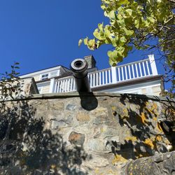
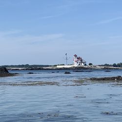
A very old fort The first idea for a fort in this location was in 1689 when the shipbuilder William Pepperell bought the land and constructed some primitive and basic defenses. By 1715 six cannon where moved here permanently and by 1808 the site became an official United States fort. A great place to protected the vital entrance to the Piscataqua River. The old fort changed a lot over the years with new things constructed and older fortifications torn down and by 1918 it fell into disuse and was abandoned. Fortunately the great historical value of the old fort was realized and it parts of it were restored and became a park and museum. The park has cool views of the river and if you squint and look really hard you can see a couple of lighthouses. The Blockhouse that was constructed in 1884 is open in the summer and you can climb around the massive granite stones and poke around in the old tunnels. A cool old fort that is a fun place to spend some time. A nice chunk of the past that manages to combine history with some lovely and scenic views of the river.

For what it is--an old fort--it's pretty cool. You can actually walk into everything--there is no employee there telling you to keep your hands to yourself, and it is set up to let you see it all. My favorite part was their explanation for why the bunker house was built--they have no idea. These houses were obsolete before they started building this one. In my opinion, Fort Constitution across the water in New Hampshire is more interesting, though.

We got lucky. Before heading west later this week, I wanted to spend a day with some ocean views. Attempted to go to Oriodone Point State Park in NH, but the place was packed (Seriously- with $10 pp entrance fees and no beach who goes there???). So I looked at my Waze map, found a green spot further north, dropped a pin, and off we went. We arrived at Fort McClary State Park. It's a tiny Park, overlooking the piscatagua river harbor. Views of 2 lighthouses and a few islands. And lots of sailboats. Nice breeze off the water. Quite a few benches and some picnic tables. Your choice of sun or shade. We spent a bit of time walking the grounds then brought out the picnic basket. Enjoyed our picnic while watching incompetent sailors out on the water. It seemed like most of the people visiting were either locals walking their dogs. Or people who actually came to check out the fort. We were the only ones picnicking(and after a bad experience being invaded by brown bag gets yesterday, we were quite happy to be the only picnickers). After eating we decided to check out the fort. It was kinda boring. Seemed to be a mishmash of a bunch of different forts from different eras. I was bored with the fort. Hence loss of a star.

I discovered this old fort back in the late 80s as I drove the back roads between Manchester, NH and Ogunquit, ME. l lived in Manchester, but spent many of my days off driving around southern ME and sitting on the rocky shoreline of Ogunquit. To find the fort, you need to get on Route 103. This is the location per the website directions: 2 1/2 miles from U.S. Route 1 and Maine Turnpike on Kittery Point Road (Route 103) (turn at rotary). Going south, it's a hard turn to the right; and a hard turn to the left when northbound. Here's more info from the website: For more than 275 years, a fort has stood to protect the approaches to the Piscataqua River at the southern gateway to Kittery, Maine. The most recent of these is Fort McClary, named for New Hampshire native Major Andrew McClary who died at the Revolutionary War's Battle of Bunker Hill. Fort McClary stands today as one of the state's most important historic forts that dramatically preserves evidence of military history and changes in military architecture and technology. The buildings presently on the site represent several different periods of construction as the fort was upgraded and modified to meet the area's defensive needs. The site was manned during five wars - The Revolutionary War, War of 1812, Civil War, Spanish-American War, and World War I. Like most other Maine forts, it saw little conflict. There's a fee drop box. I believe it's $2 per person. You can park right near the entrance. The grounds are located in a little cove which gives you a feel for the many nooks and crannies of the Maine coastline. You can see the ME boundry on the left, and NH on the right. The structures are interesting as well.

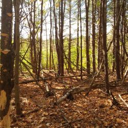
During our visit in early May there were few people here making for a quiet visit. There are several picnic tables and a few benches scattered around the property with beautiful views of the water. This fort was active through many wars and then decommissioned while building a protective wall around the property. Huge slabs of quarried stone, partually carved blocks and lots of stone 'chips' are scattered about. There are a few information signs detailing the history of Fort McClary and some buildings have signs that state the building purpose. Foundations of some buildings is all that remains. They have a few cannons on display. Check out their website for information on events and when the fort is manned. There is a seperate picnic grove up the road about 50 yards across the street. A dirt parking lot holds around a dozen vehicles or so and there is an 'RV turn around' area, but no parking for RV's or busses here. One outhouse is located past the end of the parking lot. There is a wooded trail at the back corner. read more


3 years ago
A nice outing. The structures are still in good shape, lots of history here. Especially loved the map that shows where things are in front of you. Views of Constitution Light (NH) and Whaleback Light, which is actually just a short 10 minute drive away and we went to visit that after! Sign said they officially open Memorial day but the picnic area across the street was open. read more


Working through my Maine State Parks pass, we revisited Fort McClary around Memorial Day weekend. There were a couple of families using the picnic tables, some folks walking their dogs, but we were able to once again explore the grounds at our own pace (probably helped that it was kind of a cool and misty day)! As I mentioned in my first review: they really did a wonderful job preserving the area. There's sweeping ocean (and, of course, lighthouse) views, spacious green lawns, a small hiking trail behind the parking lot (I think part of it might accidentally lead into someone's backyard!; one part brings you all the way to the entrance), and all the fun things kids/kids-at-heart can climb all over. From the canons to the bunker (you can go down inside it; be careful, it's wet!), the powder house to the enormous unfinished walls on the perimeter of the property, I'm impressed that people can still pretty much touch and be a part of everything! Lots of forts I grew up going to now have gates and fences and barriers up to prevent the public from walking on/too close to things for preservation purposes. Which, as I mentioned in my first review, I totally understand and respect, but I think there's something pretty cool about being able to immerse yourself in a site like this when you can get so close! We *still* weren't able to go inside the Blockhouse though! Next time! read more


5 years ago
This place has long been a favorite for my family since we were first there in 1999. On that first visit, we met an incredibly friendly and helpful park ranger (is that the right term?) named "Doc." Bright blue eyes and a generous smile, easy to talk with, and full of insider info of the area. He gave us tips on traveling through the area and what else to see. The kids, only small boys at the time, instantly adored him and Fort McClary (both the fort side and the picnic area across the street). For years we'd go back and visit and see the beloved Doc if he was around. Well, it's been a long time since we've seen our park friend. We've had many beach vacations where we've just stuck to Long Sands. We've visited Fort McClary a lot, though, often picking up a pizza at YHOP (York House of Pizza) and taking it to the fort grounds to eat & watch the boats chugging and sailing by. It's a wonderful spot for kids and adults who like to explore--there's the fort itself, some outbuildings, and even a "creepy" tunnel. Lots of grounds to run on, lots of big rocks to climb. There are picnic tables to rest at, and a very clean outdoor potty that always has enough tp and hand sanitizer. So back we went this trip (Aug. 2021), just my husband and me. It was as beautiful as ever. While we stayed out of the fort, we did walk the grounds and set up lunch at a picnic table under a tree. There was a marker for a trail I didn't remember being there before, but we didn't venture out. We watched the people and the boats, and used our binoculars to check out Fort Foster across the water. It was blissfully beautiful--sunny but in the 70s, with a little breeze and no heavy humidity/dew point. Even in the height of the summer season, there was parking and enough space to not feel at all like people were too close. Perfection. We came back another day to set up chairs and read at the picnic area across the street. We parked (there's handicapped parking in both halves of Fort McClary) and did a quick walk over to the frog pond. Didn't stay at the lookout long as there was a sign warning about a kind of fire ant they were having issues with this year. On our way to get the chairs from the car, we saw people emerge from a little path and realized we'd forgotten all about the trails to the body of water just beyond the trees (an inlet, maybe?). So off we went down a well worn trail yet informal trail system (no markers needed, just follow the obvious trail) to different points along the water, including a little "island" you can walk to where a group of young people were hanging out and swimming. It was so pretty, and we watched as a man in a wetsuit and flippers entered the water across the way and swim his way around. A young man had a radio on low, and we sat and listened to a little Bob Marley as we gazed out on the simple beauty of the place. On our way back to the car later, we saw an older man, a park ranger, walking up from an outbuilding. As he approached, we could see his sparkling blue eyes and his generous, familiar grin. It was "our Doc"!! We couldn't believe our luck! We were delighted to catch up with him after all these years. Highlight of the trip. We came back at least another time with lunch from Fat Tomato Grill (see that review--yum), and thoroughly enjoyed ourselves again. You can't lose visiting either side of the Fort McClary property! read more


 and some blocks to climb/stand on, and a whole lawn area you can set up a picnic on - Landmarks & Historical Buildings Near Me - Kittery, Maine")
3 years ago
3 years ago
3 years ago
beautiful spot! nice ocean views. the gate was closed off and not much parking available tho read more

2 years ago
12 years ago
A very old fort The first idea for a fort in this location was in 1689 when the shipbuilder William Pepperell bought the land and constructed some primitive and basic defenses. By 1715 six cannon where moved here permanently and by 1808 the site became an official United States fort. A great place to protected the vital entrance to the Piscataqua River. The old fort changed a lot over the years with new things constructed and older fortifications torn down and by 1918 it fell into disuse and was abandoned. Fortunately the great historical value of the old fort was realized and it parts of it were restored and became a park and museum. The park has cool views of the river and if you squint and look really hard you can see a couple of lighthouses. The Blockhouse that was constructed in 1884 is open in the summer and you can climb around the massive granite stones and poke around in the old tunnels. A cool old fort that is a fun place to spend some time. A nice chunk of the past that manages to combine history with some lovely and scenic views of the river. read more


9 years ago
For what it is--an old fort--it's pretty cool. You can actually walk into everything--there is no employee there telling you to keep your hands to yourself, and it is set up to let you see it all. My favorite part was their explanation for why the bunker house was built--they have no idea. These houses were obsolete before they started building this one. In my opinion, Fort Constitution across the water in New Hampshire is more interesting, though. read more


9 years ago
We got lucky. Before heading west later this week, I wanted to spend a day with some ocean views. Attempted to go to Oriodone Point State Park in NH, but the place was packed (Seriously- with $10 pp entrance fees and no beach who goes there???). So I looked at my Waze map, found a green spot further north, dropped a pin, and off we went. We arrived at Fort McClary State Park. It's a tiny Park, overlooking the piscatagua river harbor. Views of 2 lighthouses and a few islands. And lots of sailboats. Nice breeze off the water. Quite a few benches and some picnic tables. Your choice of sun or shade. We spent a bit of time walking the grounds then brought out the picnic basket. Enjoyed our picnic while watching incompetent sailors out on the water. It seemed like most of the people visiting were either locals walking their dogs. Or people who actually came to check out the fort. We were the only ones picnicking(and after a bad experience being invaded by brown bag gets yesterday, we were quite happy to be the only picnickers). After eating we decided to check out the fort. It was kinda boring. Seemed to be a mishmash of a bunch of different forts from different eras. I was bored with the fort. Hence loss of a star. read more


17 years ago
I discovered this old fort back in the late 80s as I drove the back roads between Manchester, NH and Ogunquit, ME. l lived in Manchester, but spent many of my days off driving around southern ME and sitting on the rocky shoreline of Ogunquit. To find the fort, you need to get on Route 103. This is the location per the website directions: 2 1/2 miles from U.S. Route 1 and Maine Turnpike on Kittery Point Road (Route 103) (turn at rotary). Going south, it's a hard turn to the right; and a hard turn to the left when northbound. Here's more info from the website: For more than 275 years, a fort has stood to protect the approaches to the Piscataqua River at the southern gateway to Kittery, Maine. The most recent of these is Fort McClary, named for New Hampshire native Major Andrew McClary who died at the Revolutionary War's Battle of Bunker Hill. Fort McClary stands today as one of the state's most important historic forts that dramatically preserves evidence of military history and changes in military architecture and technology. The buildings presently on the site represent several different periods of construction as the fort was upgraded and modified to meet the area's defensive needs. The site was manned during five wars - The Revolutionary War, War of 1812, Civil War, Spanish-American War, and World War I. Like most other Maine forts, it saw little conflict. There's a fee drop box. I believe it's $2 per person. You can park right near the entrance. The grounds are located in a little cove which gives you a feel for the many nooks and crannies of the Maine coastline. You can see the ME boundry on the left, and NH on the right. The structures are interesting as well. read more


12 years ago
Absolutely worth the stop if you like old forts. They did a great job preserving it. There are cool bunkers to explore, cannons and a fantastic view of the harbor. read more


11 years ago
6 years ago
9 years ago
12 years ago
9 years ago
13 years ago
16 years ago
10 years ago
More info about Fort McClary
Rt 103
Kittery, ME 03904
Directions
(207) 384-5160
Call Now
Hours
Outdoor Amenities
Ask the Community - Fort McClary
Review Highlights - Fort McClary


Why does Yelp recommend reviews?
Fort McClary - landmarks - Updated July 2026
Best of Kittery
People found Fort McClary by searching for…
Things to Do in Kittery, Maine
Swimming Holes in Kittery, Maine
Scenic Drive in Kittery, Maine
Secret Spots in Kittery, Maine
Abandoned Buildings in Kittery, Maine
Walking Trails in Kittery, Maine
Hiking Trails in Kittery, Maine
Picnic Areas in Kittery, Maine
Dog Friendly Hiking Trails in Kittery, Maine
Running Trails in Kittery, Maine
Waterfall Hike in Kittery, Maine
Trending Searches in Kittery, ME
4th Of July Fireworks near Fort McClary
Black Owned Nail Salons near Fort McClary
Cliff Jumping near Fort McClary
Dog Friendly Trails near Fort McClary
Flower Fields near Fort McClary
Jet Ski Rental near Fort McClary
Kayak Rental near Fort McClary
Lakes & Ponds near Fort McClary
Landmarks & Historical Buildings near Fort McClary
Off Road Trails near Fort McClary
Outdoor Activities near Fort McClary
Picnic Areas near Fort McClary
Places To Visit near Fort McClary
Public Pools near Fort McClary
Public Shower near Fort McClary
River Swimming near Fort McClary
Running Trails near Fort McClary
Scenic Night View near Fort McClary
Scenic Overlook near Fort McClary
Scenic Restaurants near Fort McClary
Secluded Spots near Fort McClary
Soccer Store near Fort McClary
Strawberry Picking near Fort McClary
Sunrise View near Fort McClary
Swimming Holes near Fort McClary
Swimming Lakes near Fort McClary
Things To See near Fort McClary
Browse Nearby
BEST of Kittery, Maine Restaurants near Fort McClary
BEST of Kittery, Maine Coffee near Fort McClary
BEST of Kittery, Maine Things to Do near Fort McClary
BEST of Kittery, Maine Scenic Drive near Fort McClary
BEST of Kittery, Maine Breakfast near Fort McClary
BEST of Kittery, Maine Hotels near Fort McClary
Browse Brands
Related Searches in Kittery, ME
Affordable Kayak Rental Services in Kittery, Maine
Best Fishing Locations and Guides in Kittery, Maine
Best Fun Things to Do in Kittery, Maine
Best Places for Horseback Riding in Kittery, Maine
Best Sledding Spots and Fun in Kittery, Maine
Book Engaging Historical Tours in Kittery, Maine
Check Out Off Road Trails in Kittery, Maine
Discover Charming Historic Homes in Kittery, Maine
Discover Dog Friendly Trails to Explore in Kittery, Maine
Discover Family-Friendly Aquariums in Kittery, Maine
Discover Famous Monuments in Kittery, Maine
Discover Historic Sites and Places in Kittery, Maine
Discover Popular Photo Spots in Kittery, Maine
Discover Top Boat Tours in Kittery, Maine for All Ages
Discover a Hiking Trail in Kittery, Maine
Discover the Best Beaches in Kittery, Maine
Dog-Friendly Hikes With Dogs in Kittery, Maine
Enjoy Arts & Entertainment in Kittery, Maine
Enjoy Camping Adventures Around Kittery, Maine
Enjoy Exciting Mountain Biking Adventures in Kittery, Maine
Enjoy Hiking Adventures in Kittery, Maine
Enjoy Kayaking Adventures in Kittery, Maine
Enjoy Tent Camping Spots Around Kittery, Maine
Enjoy a Beautiful Waterfall Hike in Kittery, Maine
Enjoy the Best Family Activities in Kittery, Maine
Enjoy the Best Tubing Experiences in Kittery, Maine
Enjoy the Best Walking Trails in Kittery, Maine
Exciting Cliff Jumping Spots in Kittery, Maine
Experience Stunning Sunset Views in Kittery, Maine
Explore Beautiful Botanical Gardens in Kittery, Maine
Explore Beautiful Castles and Landmarks in Kittery, Maine
Explore Beautiful Parks and Green Spaces in Kittery, Maine
Explore Bike Rentals Throughout Kittery, Maine
Explore Children's Museums Near Kittery, Maine
Explore Easy Hikes Perfect for All in Kittery, Maine
Explore Family-Friendly Zoos and Wildlife in Kittery, Maine
Explore Free Things to Do Around Kittery, Maine
Explore Fun Activities to Do in Kittery, Maine
Explore Popular Campgrounds Near Kittery, Maine
Explore Popular Scenic Overlook Points in Kittery, Maine
Explore Popular View Points Around Kittery, Maine
Explore Secret Spots Worth Visiting in Kittery, Maine
Explore Top Art Galleries Located in Kittery, Maine
Explore Top Dog Parks in Kittery, Maine Near You
Explore Venues & Event Spaces in Kittery, Maine
Explore the Best Beach Spots in Kittery, Maine
Explore the Best Boating Spots in Kittery, Maine
Family Friendly Hiking With Kids in Kittery, Maine
Browse Articles
People who viewed Fort McClary also viewed
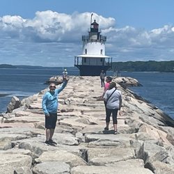
Nubble Lighthouse
201 reviews
Great Bay National Wildlife Refuge
5 reviews
Barters Creek Trail
1 review
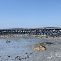
Wiggly Bridge
27 reviews
Wagon Hill Farm
2 reviews
Portsmouth Harbor Lighthouse
11 reviews
Albacore Park
60 reviews
Bellamy River Wildlife Sanctuary
2 reviews
Whaleback Lighthouse
2 reviews
Old Boston Preserve
2 reviews