DeVaul Henderson Lake Loop Photos


More like DeVaul Henderson Lake Loop
Recommended Reviews - DeVaul Henderson Lake Loop
Start your review...

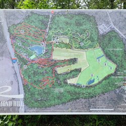
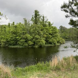
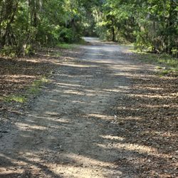
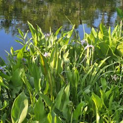
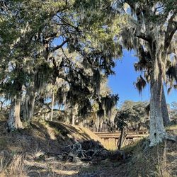
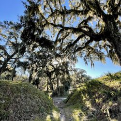
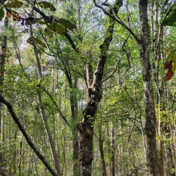
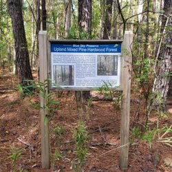
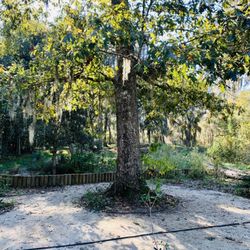
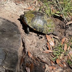
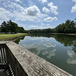
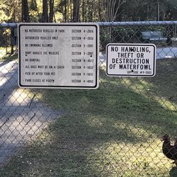
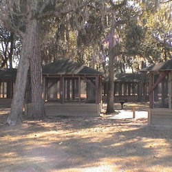
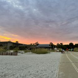
Little One and I have been cooped up in the house because she has been sick, so I took her out to get some fresh air. The DeVaul Henderson Lake Loop (DHLL) seemed to be the best bet due to length of the trail. When you are on Hwy 144 and you get to the roundabout, turn in on Veterans Memorial Parkway, where the Bryan County Administrative Complex is. The trail is located right next to it. You can't miss it. Parking - You can pretty much park anywhere on the grass along Veterans Memorial Parkway. I like to park toward the other end, by the elementary school, where you see the 4 wooden posts. Trail Description - From the 4 wooden posts, down to the paved path, the ground is dirt and a mix of sand and pine needles, and not paved, but that distance is minimal. It is surround by tall trees. Once you get down to the paved part, the signs indicate that it's a 0.5 mile loop. This loop has 3 different connection points to other parts of DeVaul Henderson Recreation Park (to soccer fields and restrooms) and I believe to the side of the Bryan County Administrative Complex. The connection points are located on the opposite side of Veterans Memorial Parkway. There are park benches all around the lake, as well as flotation devices in case someone gets in and needs some saving. There was a unique bench (kind of like one of those stone benches you see in gardens) and it had a sign "The Murphy Bench" that was placed there in memory of an infant boy. How tragic, but so touching. Difficulty Level - Easy for all ages. It is stroller and wheelchair friendly too, but might experience some bumpiness when going down that first small stretch to the paved path. Beware - There are signs that say "Beware of Wildlife". I am assuming they mean alligators, because that is what they always seem to warn you about around these parts, but we did not personally see any. But do we ever really see them when they are around? Unless they decide to come out of the water. However, we did see a lot of ducks swimming in the lake, as well as a beautiful white one just sitting on the side in the grass. This is a great place to run, walk, speed walk, scoot (my Little One took her scooter) and I saw some people fishing too. It's a great pit stop if you happen to be in the area. You can fill up on gas at the Shell Station and stretch those legs before you go on the next leg of your trip. Get outside, People! read more


2 years ago
More info about DeVaul Henderson Lake Loop
Veterans Memorial Pkwy
Richmond Hill, GA 31324
Directions
Hours
Outdoor Amenities


DeVaul Henderson Lake Loop - hiking - Updated June 2026
Best of Richmond Hill
People found DeVaul Henderson Lake Loop by searching for…
Lakes in Richmond Hill, Georgia
Things to Do in Richmond Hill, Georgia
Tennis in Richmond Hill, Georgia
Running Trails in Richmond Hill, Georgia
Hiking Trails in Richmond Hill, Georgia
Baseball Fields in Richmond Hill, Georgia
Places to Take Pictures in Richmond Hill, Georgia
Dog Swimming in Richmond Hill, Georgia
Fishing Lake in Richmond Hill, Georgia
Walking Trails in Richmond Hill, Georgia
Scenic Drive in Richmond Hill, Georgia
Dog Friendly Hiking Trails in Richmond Hill, Georgia
Crabbing Location in Richmond Hill, Georgia
Flower Fields in Richmond Hill, Georgia
Fishing Spots in Richmond Hill, Georgia
Fishing Ponds in Richmond Hill, Georgia
Tennis Court in Richmond Hill, Georgia
Photo Spots in Richmond Hill, Georgia
Waterfall in Richmond Hill, Georgia
Swimming Lakes in Richmond Hill, Georgia
Feed Ducks in Richmond Hill, Georgia
Running Tracks Open to the Public in Richmond Hill, Georgia
Trending Searches in Richmond Hill, GA
Bait And Tackle Shop near DeVaul Henderson Lake Loop
Baseball Fields near DeVaul Henderson Lake Loop
Black Owned Nail Salons near DeVaul Henderson Lake Loop
Boardwalk near DeVaul Henderson Lake Loop
Boat Rental near DeVaul Henderson Lake Loop
Crabbing Location near DeVaul Henderson Lake Loop
Day Trips near DeVaul Henderson Lake Loop
Dog Friendly Beaches near DeVaul Henderson Lake Loop
Dog Friendly Trails near DeVaul Henderson Lake Loop
Fishing Charter near DeVaul Henderson Lake Loop
Fishing Spots near DeVaul Henderson Lake Loop
Jet Ski Rental near DeVaul Henderson Lake Loop
Kayak Rental near DeVaul Henderson Lake Loop
Kids Activities Outdoor near DeVaul Henderson Lake Loop
Lakes near DeVaul Henderson Lake Loop
Nature Trails near DeVaul Henderson Lake Loop
Outdoor Activities near DeVaul Henderson Lake Loop
Parks With Pull Up Bars near DeVaul Henderson Lake Loop
Pick Your Own Farms near DeVaul Henderson Lake Loop
Picnic Spots near DeVaul Henderson Lake Loop
Pontoon Boat Rentals near DeVaul Henderson Lake Loop
Public Beaches near DeVaul Henderson Lake Loop
Public Shower near DeVaul Henderson Lake Loop
River Swimming near DeVaul Henderson Lake Loop
Scenic Drive near DeVaul Henderson Lake Loop
Scenic Night View near DeVaul Henderson Lake Loop
Scenic Overlook near DeVaul Henderson Lake Loop
Secluded Spots near DeVaul Henderson Lake Loop
Soccer Store near DeVaul Henderson Lake Loop
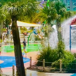
Splash Pad near DeVaul Henderson Lake Loop
Strawberry Picking near DeVaul Henderson Lake Loop
Sunbathing near DeVaul Henderson Lake Loop
Sunrise View near DeVaul Henderson Lake Loop
Sunset Cruise near DeVaul Henderson Lake Loop
Swimming Holes near DeVaul Henderson Lake Loop
Swimming Lakes near DeVaul Henderson Lake Loop
Swimming Pools near DeVaul Henderson Lake Loop
Browse Nearby
Browse Brands
Related Searches in Richmond Hill, GA
Affordable Fishing Rental Services in Richmond Hill, Georgia
Affordable Jet Ski Rental Options in Richmond Hill, Georgia
Affordable Kayak Rental Services in Richmond Hill, Georgia
Best Crabbing Locations to Visit in Richmond Hill, Georgia
Best Fishing Locations and Guides in Richmond Hill, Georgia
Best Off Leash Dog Parks in Richmond Hill, Georgia
Best Parks for Parties and Events in Richmond Hill, Georgia
Best Places for Horseback Riding in Richmond Hill, Georgia
Boat Services and Rentals Available in Richmond Hill, Georgia
Book Top Fishing Trips in Richmond Hill, Georgia Today
Check Out Great Playgrounds in Richmond Hill, Georgia
Check Out Off Road Trails in Richmond Hill, Georgia
Discover Baseball Fields Around Richmond Hill, Georgia
Discover Beautiful Garden Spots in Richmond Hill, Georgia
Discover Dog Friendly Trails to Explore in Richmond Hill, Georgia
Discover Exciting Adventure Options in Richmond Hill, Georgia
Discover Free Parking Options in Richmond Hill, Georgia
Discover Fun Activities to Do in Richmond Hill, Georgia
Discover Scenic Mountain Bike Trails Near Richmond Hill, Georgia
Discover Scenic Waterfall Spots in Richmond Hill, Georgia
Discover Soccer Fields in Richmond Hill, Georgia Near You
Discover Top Boat Tours in Richmond Hill, Georgia for All Ages
Discover Top Nature Parks to Visit in Richmond Hill, Georgia
Discover Top State Parks to Visit in Richmond Hill, Georgia
Discover a Hiking Trail in Richmond Hill, Georgia
Discover the Best Beaches in Richmond Hill, Georgia
Discover the Best Fishing Lake in Richmond Hill, Georgia
Discover the Best Sunset Cruise Tours in Richmond Hill, Georgia
Dog-Friendly Hikes With Dogs in Richmond Hill, Georgia
Enjoy Camping Adventures Around Richmond Hill, Georgia
Enjoy Exciting Mountain Biking Adventures in Richmond Hill, Georgia
Enjoy Fishing Pier Spots in Richmond Hill, Georgia With Scenic Views
Enjoy Fishing With Kids in Richmond Hill, Georgia Safely
Enjoy Hiking Adventures in Richmond Hill, Georgia
Enjoy Jet Ski Adventures in Richmond Hill, Georgia
Enjoy Kayaking Adventures in Richmond Hill, Georgia
Enjoy Sailing Adventures in Richmond Hill, Georgia
Enjoy Tent Camping Spots Around Richmond Hill, Georgia
Enjoy a Dog Beach Day in Richmond Hill, Georgia
Enjoy a Scenic Boat Ride in Richmond Hill, Georgia
Enjoy the Best Family Activities in Richmond Hill, Georgia
Enjoy the Best Picnic Spots and Ideas in Richmond Hill, Georgia
Enjoy the Best Walking Trails in Richmond Hill, Georgia
Experience Deep Sea Fishing Adventures in Richmond Hill, Georgia
Experience Scenic Boat Cruises in Richmond Hill, Georgia
Experience Thrilling Parasailing Adventures in Richmond Hill, Georgia
Experienced Fishing Guides Available in Richmond Hill, Georgia
Explore Beautiful Parks and Green Spaces in Richmond Hill, Georgia
Explore Bike Rentals Throughout Richmond Hill, Georgia
Explore Easy Hikes Perfect for All in Richmond Hill, Georgia