Custis Trail Photos


You might also consider
More like Custis Trail
Recommended Reviews - Custis Trail
Start your review...

Reviews With Photos

Trail opening from Ballston is along N Fairfax near Marymount University. Wish I started running on this trail years ago! But, the hills didn't seem so bad until my run back -- omg! I went towards Rosslyn/DC and then continued on the Mt Vernon trail. Nice paved trail and scenery along the way. Ran all the way to the Kennedy Center into DC. Very hilly run back where I had to start walking.. great workout!

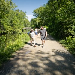
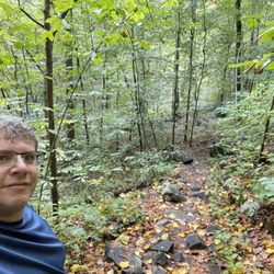
GREAT urban trail gets you off the roads and under some trees. Lots of bikers, joggers, dogs with humans, and folks walking for fun/exercise or going someplace. Protective barriers in place to mitigate vehicle noise pollution, maps to plot your path, signs with direction and distance to prominent destinations, and strategically placed trash cans for trash or poop deposits. Asphalt walkways are in great condition. I didn't go looking for it, but it found me and gave me some peace when I needed it - and I didn't need to break stride. Find it / use it!

11 months ago
2 years ago
Trail opening from Ballston is along N Fairfax near Marymount University. Wish I started running on this trail years ago! But, the hills didn't seem so bad until my run back -- omg! I went towards Rosslyn/DC and then continued on the Mt Vernon trail. Nice paved trail and scenery along the way. Ran all the way to the Kennedy Center into DC. Very hilly run back where I had to start walking.. great workout! read more
GREAT urban trail gets you off the roads and under some trees. Lots of bikers, joggers, dogs with humans, and folks walking for fun/exercise or going someplace. Protective barriers in place to mitigate vehicle noise pollution, maps to plot your path, signs with direction and distance to prominent destinations, and strategically placed trash cans for trash or poop deposits. Asphalt walkways are in great condition. I didn't go looking for it, but it found me and gave me some peace when I needed it - and I didn't need to break stride. Find it / use it! read more


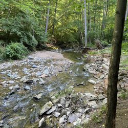
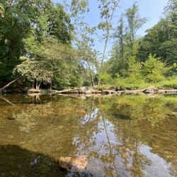
One word: hills! If you're looking for a flat trail to walk, ride, or run, this is *not* for you. Custis Trail is full of rolling hills meaning huge dips and steep inclines. If you're training for a race, you can get in great hill work to improve your endurance. Several running groups use this trail for training in the Arlington area. Its well paved, clear of debris, and tons of runners. Not as many cyclists as you would see on the flat trails so you will not feel like you're going to get hit. Also, it runs parallel to 66, connects to the W&OD trail heading west. You can get on the C&O Towpath heading east once you head over Key Bridge, or link up to the Mt. Vernon Trail at the bottom of the trail in Rosslyn. From time to time you will see rabbits and once I even saw a fox. One of my favorite trails for walking/running. read more


17 years ago
16 years ago
15 years ago
12 years ago
10 years ago
15 years ago
16 years ago
12 years ago
13 years ago
15 years ago
12 years ago
13 years ago
More info about Custis Trail
Ask the Community - Custis Trail
Review Highlights - Custis Trail
You might also consider


Why does Yelp recommend reviews?
1 review that is not currently recommended
The reviews below are not factored into the business's overall star rating.
16 years ago
Custis Trail - hiking - Updated July 2026
Best of Arlington
People found Custis Trail by searching for…
Running Trails in Arlington, VA
Walking Trails in Arlington, VA
Fun Things to Do in Arlington, VA
Mountain Biking in Arlington, VA
Walking Groups in Arlington, VA
Places to Take Pictures in Arlington, VA
Stroller Friendly Hikes in Arlington, VA
Waterfall Hike in Arlington, VA
Free Things to Do in Arlington, VA
Running Routes in Arlington, VA
Places to Walk Around in Arlington, VA
Things to Do Alone in Arlington, VA
Off Road Trails in Arlington, VA
Off Leash Dog Hikes in Arlington, VA
Things to Do Today in Arlington, VA
Hiking With Kids in Arlington, VA
Trending Searches in Arlington, VA
Black Owned Nail Salons in Arlington, VA
Cliff Jumping in Arlington, VA
Jet Ski Rental in Arlington, VA
Lakes & Ponds in Arlington, VA
Off Road Trails in Arlington, VA
Outdoor Activities in Arlington, VA
Places To Swim in Arlington, VA
Places To Walk Around in Arlington, VA
Pool Day Pass in Arlington, VA
Public Shower in Arlington, VA
River Swimming in Arlington, VA
Running Trails in Arlington, VA
Scenic Night View in Arlington, VA
Scenic Overlook in Arlington, VA
Swimming Holes in Arlington, VA
Browse Articles
Browse Nearby
BEST of Arlington, Virginia Restaurants near Custis Trail
BEST of Arlington, Virginia Coffee near Custis Trail
BEST of Arlington, Virginia Things to Do near Custis Trail
BEST of Arlington, Virginia Walking Trails near Custis Trail
BEST of Arlington, Virginia Breakfast near Custis Trail
BEST of Arlington, Virginia Parks near Custis Trail
BEST of Arlington, Virginia Campgrounds near Custis Trail
Browse Brands
Related Searches in Arlington, VA
Affordable Kayak Rental Services in Arlington, Virginia
Best Fishing Locations and Guides in Arlington, Virginia
Best Nature Trails for Hiking in Arlington, Virginia
Best Places for Horseback Riding in Arlington, Virginia
Best Waterfalls and Swimming Holes in Arlington, Virginia
Check Out Off Road Trails in Arlington, Virginia
Discover Dog Friendly Trails to Explore in Arlington, Virginia
Discover Kid Friendly Hiking Trails in Arlington, Virginia
Discover Scenic Mountain Bike Trails Near Arlington, Virginia
Discover Top Nature Parks to Visit in Arlington, Virginia
Discover a Hiking Trail in Arlington, Virginia
Discover the Best Night Hike Trails in Arlington, Virginia
Dog-Friendly Hikes With Dogs in Arlington, Virginia
Enjoy Camping Adventures Around Arlington, Virginia
Enjoy Exciting Mountain Biking Adventures in Arlington, Virginia
Enjoy Kayaking Adventures in Arlington, Virginia
Enjoy Tent Camping Spots Around Arlington, Virginia
Enjoy a Beautiful Waterfall Hike in Arlington, Virginia
Enjoy a Peaceful Nature Walk in Arlington, Virginia
Enjoy the Best Walking Path in Arlington, Virginia
Enjoy the Best Walking Trails in Arlington, Virginia
Exciting Cliff Jumping Spots in Arlington, Virginia
Explore Beautiful Parks and Green Spaces in Arlington, Virginia
Explore Easy Hikes Perfect for All in Arlington, Virginia
Explore Fun Activities to Do in Arlington, Virginia
Explore Popular Campgrounds Near Arlington, Virginia
Explore the Best Beach Spots in Arlington, Virginia
Explore the Best Boating Spots in Arlington, Virginia
Explore the Best Swimming Holes Around Arlington, Virginia
Explore the Best Trail Options in Arlington, Virginia
Family Friendly Hiking With Kids in Arlington, Virginia
Find Popular Ziplining Spots Around Arlington, Virginia
Find the Best Parks for Picnics in Arlington, Virginia
Find the Best Scenic View Locations in Arlington, Virginia
Great Places to Walk in Arlington, Virginia
Hiking Trails With Waterfalls in Arlington, Virginia
Off Leash Dog Hiking Trails in Arlington, Virginia
Plan a Scenic Drive Route Near Arlington, Virginia
Popular Fishing Spots to Explore in Arlington, Virginia
Popular Outdoor Activities to Try in Arlington, Virginia
Popular Picnic Spots to Visit in Arlington, Virginia
Safe River Swimming Areas in Arlington, Virginia
Safe and Fun Parks for Kids in Arlington, Virginia
Top Climbing Spots and Gyms in Arlington, Virginia
Top Paddleboarding Activities in Arlington, Virginia
Top Places for Snorkeling in Arlington, Virginia
Top Running Trails to Explore in Arlington, Virginia
Top Swimming Lakes to Enjoy in Arlington, Virginia
People who viewed Custis Trail also viewed
Holmes Run Stream Valley Park
8 reviews
Holmes Run Scenic Easement
2 reviews
Howard E Herman Stream Valley Park
2 reviews
Falls Church City
Shirlington Park
2 reviews
Shirlington
Washington & Old Dominion Regional Park
8 reviews
Winkler Botanical Preserve
24 reviews
Carrleigh Parkway Park
1 review
Lady Bird Johnson Park
7 reviews
Four Mile Run Park
3 reviews
Oronoco Bay Park
21 reviews
Old Town Alexandria