CSO Well Number 4 Photos


You might also consider
More like CSO Well Number 4
Recommended Reviews - CSO Well Number 4
Start your review...

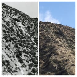
The first commercially successful oil well in the western United States and also the longest-running oil well in the world up until 1990. I wouldn't make a separate trip to view it unless you're an oil history buff. If your visit includes Mentryville and Pico Canyon trail then it's well worth the trip. California Historical Landmark No. 516 WELL, CSO 4 (PICO 4) - The inscription reads: On this site stands CSO-4 (Pico No. 4), California's first commercially productive well. It was spudded in early 1876 under direction of Demetrious G. Scofield who later became the first president of Standard Oil Company of California, and was completed at a depth of 300 feet on September 26, 1876, for an initial flow of 30 barrels of oil a day. Later that year, after the well was deepened to 600 feet with what was perhaps the first steam rig employed in oil well drilling in California, it produced at a rate of 150 barrels a day - it is still producing after 77 years (1953). The success of this well prompted formation of the Pacific Coast Oil Company, a predecessor of Standard Oil Company of California, and led to the construction of the state's first refinery nearby. It was not only the discovery well of the Newhall Field, but was a powerful stimulus to the subsequent development of the California petroleum industry. Location: On W Pico Canyon Rd, 3.3 mi W of I-5, Newhall read more


17 years ago
More info about CSO Well Number 4


CSO Well Number 4 - landmarks - Updated May 2026
Best of Newhall
People found CSO Well Number 4 by searching for…
Tourist Attractions in Newhall, California
Scenic Drive in Newhall, California
Historical Sites in Newhall, California
Scenic Overlook in Newhall, California
Sightseeing in Newhall, California
Old Town in Newhall, California
Beautiful Views in Newhall, California
Places to Take Pictures in Newhall, California
Hiking Trails in Newhall, California
Urban Exploration in Newhall, California
Night View in Newhall, California
Museums in Newhall, California
Walking Path in Newhall, California
Walking Trails in Newhall, California
Running Trails in Newhall, California
Observation Deck in Newhall, California
Boardwalk in Newhall, California
Photo Spots in Newhall, California
State Parks in Newhall, California
Browse Nearby
BEST of Newhall, California Restaurants near CSO Well Number 4
BEST of Newhall, California Coffee near CSO Well Number 4
BEST of Newhall, California Things to Do near CSO Well Number 4
BEST of Newhall, California Parks near CSO Well Number 4
BEST of Newhall, California Breakfast near CSO Well Number 4
Browse Brands
Browse Articles
People who viewed CSO Well Number 4 also viewed
Pioneer Oil Refinery
4 reviews
Mission Wells and the Settling Basin
1 review
Sylmar
Pyramid Rock
1 review
Mission Dam Historical Site
1 review
Mission Hills
Lang Southern Pacific Station
1 review
Chatsworth Reservoir Kiln Site
2 reviews
Rancho San Francisco
1 review
Three Sisters Rock
2 reviews
Lyons Station Stagecoach Stop
2 reviews
New Year's Flood of 1934 Monument
2 reviews