Conway Robinson State Forest Photos
 - Hiking Near Me - Gainesville, Virginia")


You might also consider
More like Conway Robinson State Forest
Recommended Reviews - Conway Robinson State Forest
Start your review...

Reviews With Photos

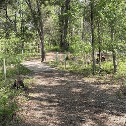
The Conway Robinson State Forest is a nice little wooded parcel off U.S. 29 - just east of Gainesville, VA. A small swath of private land separates the Forest from Manassas National Battlefield Park. There are a number of hiking trails here. It's perfect for getting out and away for a nice walk or hike in the woods. You could work in any number of hikes with the network of trails here - up to a five mile hike or so! The trails are marked with color blazes. The trail difficulty is easy to moderate. There are a few moderate slopes on some of the trails - and some of the trails are quite rocky, so keep an eye on your footwork as you hike along. At the parking lot there is a kiosk with a map of the Forest. The trails are color coded. You can also find a trail map in pdf form on the web site for the Conway Robinson State Forest: http://www.dof.virginia.gov/stforest/resources/ConRob-Map-Trail.pdf The Virginia Department of Forestry manages this land. They have a scientific research plot on the Forest - comparing a protected patch of land to the surrounding Forest. The protected patch is fenced off to exclude Deer from browsing the vegetation. There is an interpretive sign explaining the research project. Very interesting! Get out in the woods! Listen to the wind whispering through the trees, enjoy the sounds of the Forest - fuel your spirit with a dose of nature!

We passed by this park and never even noticed the sign until my husband's co worker told him about it. While the sign is prominent it was easy to miss as cars go by possibly going 45-55 miles an hour near the Battlefield in Manassas, off Highway 29. The long trail (blue) loops around the outer part of forest for a total of 3.2 miles. In the inner loop, there's little patches of red trails. There's a parking area where you can enter either to the left or right of the blue trail. If you start on the right entrance, you will run into an arrow sign that directs left for the horses and arrow pointing right for the hikers. We started our trek to the left and only saw this sign as we near the end of our hike. It's mainly a flat hike with patches of gravel or rocks and a few well kept small area of flank woods over gravel. If you live close to this area I highly recommend if you want an easy 3-mile type hike. This place is also a favorite for mountain bike riders and horse riders because the trail itself is wider than most, well maintained, and risk free injury. Although for my hike today I was surprised by a bee that stung me on my left lower leg; fortunately it only left a little bump and a red dot in the middle of an inch round skin inflammation. At least I know i'm not allergic even while the sting from the bite still lingers (3 hours later). No worries, I think it was an isolated incident because when I swatted it off my leg we did not see any after that. So go and get out there and enjoy a little bit of nature on a good day. Today's weather was perfect for it at about 64 degrees around 9:30am when we started hoping to get back in time for the 1pm Redskins game. I actually suggested going to the golf course for a few swings but glad we hiked instead, just perfect weather for it earlier in the day.

This was a very secluded small park. There was free parking and easy access. Depending which trail you take your run/hike can be 1-3 miles. The trail itself was flat, very narrow and not kept up well. It is very easy to get lost throughout the trail because there are a lot of mini trails that are unmarked. It is not a difficult trail to run but would take a running buddy for safety.

This is a little hidden gem in Northwestern Prince William county. Most people don't know it exists, but it's there, just off of 29. It's a tiny little managed hardwood forest with hiking, horseback riding, and bicycling trails all throughout the 444 acres. There are also picnic tables and a covered pavilion. Be careful in the late spring/early summer as there are a TON of ticks and mosquitoes. Hiking can be a little treacherous at times because of the bikers that churn up the muddy ground, but it's a pretty easy hike over mostly level ground. There are maps available from the DOF site, as well as one being posted at the entrance.

I usually go to Manassas Battlefield for my hikes, but wanted to try something different. This is a great change of pace. Quiet and off the beaten path. If you like forest scenery it is the place. Beware of coming after a rainy day because the path while mostly level is mainly dirt. I can see tracks of dirt bikes. Not much elevation but a nice 3 mile circle.

Big fan of this place!! I'm so hesitant to write a review just because I love how peaceful this place is without all of the tourists. For years I have talked about finding a place to walk the dog that isn't so crowded (great falls, bull run, etc.) My husband rides his bike here and decided to take me one day. It's so quite and peaceful and the trails are great! They have multiple trails, some harder than others, but I love them all. There are more bikers than hikers here, so it's very important to have your pets leashed! This will always be my weekend go to place to get my dog and myself exercise! A pooped dog is a happy dog! ;-)

Drove down here on the weekend, in the heart of the wintertime. Visiting the area around Bristow with my mom + sister, so figured this would be a good spot to walk the dog. Plus, this was technically on the way back, so it worked out nicely for us. Entrance to the park is a bit tricky -- just go straight at the traffic light at the end of the road. The road is narrow, and it's easy to miss it by heading left instead -- a mistake we almost made. The parking lot is not spacious but there were lot of free spots at the time we went. Thankfully it was not too busy. Only I got down, as it was rather cold weather. I walked our dog for a good half-hour. Trees everywhere, the scenery was nice. A bit muddy at parts, but not overly so. I recommend bringing a pair of hiking shoes just in case. Trail ran through the woods, with some interesting views. Saw all kinds of trees -- long and narrow ones, fallen ones, dead and decaying ones where the wood gave way when you stepped on them. The walk felt kind of lonely though -- I honestly didn't see another soul on the walk. I figured it might be the weather or something. My dog enjoyed it a lot. I did too for the most part. The views were nice and relaxing, very calming overall. I am a fan of the cold, so that helped too. Overall, cool spot. Nice wooded trail area for casual walks, and for bringing the dog on. Last visited: 1/7/23 read more


1 year ago
4 years ago
The Conway Robinson State Forest is a nice little wooded parcel off U.S. 29 - just east of Gainesville, VA. A small swath of private land separates the Forest from Manassas National Battlefield Park. There are a number of hiking trails here. It's perfect for getting out and away for a nice walk or hike in the woods. You could work in any number of hikes with the network of trails here - up to a five mile hike or so! The trails are marked with color blazes. The trail difficulty is easy to moderate. There are a few moderate slopes on some of the trails - and some of the trails are quite rocky, so keep an eye on your footwork as you hike along. At the parking lot there is a kiosk with a map of the Forest. The trails are color coded. You can also find a trail map in pdf form on the web site for the Conway Robinson State Forest: http://www.dof.virginia.gov/stforest/resources/ConRob-Map-Trail.pdf The Virginia Department of Forestry manages this land. They have a scientific research plot on the Forest - comparing a protected patch of land to the surrounding Forest. The protected patch is fenced off to exclude Deer from browsing the vegetation. There is an interpretive sign explaining the research project. Very interesting! Get out in the woods! Listen to the wind whispering through the trees, enjoy the sounds of the Forest - fuel your spirit with a dose of nature! read more


We passed by this park and never even noticed the sign until my husband's co worker told him about it. While the sign is prominent it was easy to miss as cars go by possibly going 45-55 miles an hour near the Battlefield in Manassas, off Highway 29. The long trail (blue) loops around the outer part of forest for a total of 3.2 miles. In the inner loop, there's little patches of red trails. There's a parking area where you can enter either to the left or right of the blue trail. If you start on the right entrance, you will run into an arrow sign that directs left for the horses and arrow pointing right for the hikers. We started our trek to the left and only saw this sign as we near the end of our hike. It's mainly a flat hike with patches of gravel or rocks and a few well kept small area of flank woods over gravel. If you live close to this area I highly recommend if you want an easy 3-mile type hike. This place is also a favorite for mountain bike riders and horse riders because the trail itself is wider than most, well maintained, and risk free injury. Although for my hike today I was surprised by a bee that stung me on my left lower leg; fortunately it only left a little bump and a red dot in the middle of an inch round skin inflammation. At least I know i'm not allergic even while the sting from the bite still lingers (3 hours later). No worries, I think it was an isolated incident because when I swatted it off my leg we did not see any after that. So go and get out there and enjoy a little bit of nature on a good day. Today's weather was perfect for it at about 64 degrees around 9:30am when we started hoping to get back in time for the 1pm Redskins game. I actually suggested going to the golf course for a few swings but glad we hiked instead, just perfect weather for it earlier in the day. read more


This was a very secluded small park. There was free parking and easy access. Depending which trail you take your run/hike can be 1-3 miles. The trail itself was flat, very narrow and not kept up well. It is very easy to get lost throughout the trail because there are a lot of mini trails that are unmarked. It is not a difficult trail to run but would take a running buddy for safety. read more


5 years ago
15 years ago
This is a little hidden gem in Northwestern Prince William county. Most people don't know it exists, but it's there, just off of 29. It's a tiny little managed hardwood forest with hiking, horseback riding, and bicycling trails all throughout the 444 acres. There are also picnic tables and a covered pavilion. Be careful in the late spring/early summer as there are a TON of ticks and mosquitoes. Hiking can be a little treacherous at times because of the bikers that churn up the muddy ground, but it's a pretty easy hike over mostly level ground. There are maps available from the DOF site, as well as one being posted at the entrance. read more


9 years ago
I usually go to Manassas Battlefield for my hikes, but wanted to try something different. This is a great change of pace. Quiet and off the beaten path. If you like forest scenery it is the place. Beware of coming after a rainy day because the path while mostly level is mainly dirt. I can see tracks of dirt bikes. Not much elevation but a nice 3 mile circle. read more


11 years ago
Big fan of this place!! I'm so hesitant to write a review just because I love how peaceful this place is without all of the tourists. For years I have talked about finding a place to walk the dog that isn't so crowded (great falls, bull run, etc.) My husband rides his bike here and decided to take me one day. It's so quite and peaceful and the trails are great! They have multiple trails, some harder than others, but I love them all. There are more bikers than hikers here, so it's very important to have your pets leashed! This will always be my weekend go to place to get my dog and myself exercise! A pooped dog is a happy dog! ;-) read more


5 years ago
12 years ago
10 years ago
Great for hiking, mountain biking, and trail running. Could be fun for a picnic too. I did some hiking here. A full loop around the whole park is about 3 miles so it's not that expansive as compared to the national battlefields in Manassas. There's plenty of winding paths to follow through the woods. The main road and surrounding housing developments are not too far away but at the center of the forest you get a good feel of being in the woods. The trails are well maintained. They have some cool signage explaining the forest growth and the history of Conway Robinson. Have fun exploring the forest not too far from the hustle and bustle of Northern VA. read more

13 years ago
12 years ago
9 years ago
12 years ago
More info about Conway Robinson State Forest
Lee Hwy And University Blvd
Gainesville, VA 20155
Directions
(434) 977-6555
Call Now
Hours
Payment methods
Outdoor Amenities
Ask the Community - Conway Robinson State Forest
Can I use a jogging stroller on these paths?
I am right now! However I'm walking. Might be a little bumpy running for a baby!!
Review Highlights - Conway Robinson State Forest
You might also consider


Why does Yelp recommend reviews?
1 review that is not currently recommended
The reviews below are not factored into the business's overall star rating.
15 years ago
Conway Robinson State Forest - hiking - Updated July 2026
Best of Gainesville
People found Conway Robinson State Forest by searching for…
Parks in Gainesville, Virginia
Things to Do in Gainesville, Virginia
Places to Take Pictures in Gainesville, Virginia
Dirt Bike Riding in Gainesville, Virginia
Hiking Trails With Waterfalls in Gainesville, Virginia
Playgrounds in Gainesville, Virginia
Secret Spots in Gainesville, Virginia
Picnic Areas in Gainesville, Virginia
Off Road Trails in Gainesville, Virginia
Secluded Spots in Gainesville, Virginia
Walking Trails in Gainesville, Virginia
Mountain Bike Trails in Gainesville, Virginia
Running Trails in Gainesville, Virginia
Swimming Lakes in Gainesville, Virginia
Dog Friendly Hiking Trails in Gainesville, Virginia
Parks BBQ Grills in Gainesville, Virginia
Sunrise View in Gainesville, Virginia
Lookout Points in Gainesville, Virginia
Parks for Kids in Gainesville, Virginia
Things to Do on a Rainy Day in Gainesville, Virginia
Easy Hiking Trails in Gainesville, Virginia
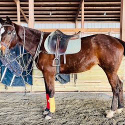
Horse Rental in Gainesville, Virginia
Trending Searches in Gainesville, VA
Black Owned Nail Salons near Conway Robinson State Forest
Boat Rental near Conway Robinson State Forest
Cliff Jumping near Conway Robinson State Forest
Day Trips near Conway Robinson State Forest
Dog Friendly Trails near Conway Robinson State Forest
Dog Swimming near Conway Robinson State Forest
Jet Ski Rental near Conway Robinson State Forest
Kayak Rental near Conway Robinson State Forest
Lakes & Ponds near Conway Robinson State Forest
Off Road Trails near Conway Robinson State Forest
Outdoor Activities near Conway Robinson State Forest
Places To Walk Around near Conway Robinson State Forest
Pool Day Pass near Conway Robinson State Forest
Public Pools near Conway Robinson State Forest
Public Shower near Conway Robinson State Forest
River Swimming near Conway Robinson State Forest
Rock Quarry near Conway Robinson State Forest
Scenic Night View near Conway Robinson State Forest
Scenic Overlook near Conway Robinson State Forest
Secluded Spots near Conway Robinson State Forest
Soccer Store near Conway Robinson State Forest
Splash Pad near Conway Robinson State Forest
Strawberry Picking near Conway Robinson State Forest
Sunrise View near Conway Robinson State Forest
Swimming Holes near Conway Robinson State Forest
Swimming Lakes near Conway Robinson State Forest
Watch Sunset near Conway Robinson State Forest
Browse Articles
Browse Nearby
BEST of Gainesville, Virginia Restaurants near Conway Robinson State Forest
BEST of Gainesville, Virginia Coffee near Conway Robinson State Forest
BEST of Gainesville, Virginia Things to Do near Conway Robinson State Forest
BEST of Gainesville, Virginia Parks near Conway Robinson State Forest
BEST of Gainesville, Virginia Breakfast near Conway Robinson State Forest
BEST of Gainesville, Virginia Playgrounds near Conway Robinson State Forest
BEST of Gainesville, Virginia Taxis near Conway Robinson State Forest
BEST of Gainesville, Virginia Campgrounds near Conway Robinson State Forest
Browse Brands
Related Searches in Gainesville, VA
Affordable Horse Boarding Services in Gainesville, Virginia
Affordable Jet Ski Rental Options in Gainesville, Virginia
Affordable Kayak Rental Services in Gainesville, Virginia
Best Fishing Locations and Guides in Gainesville, Virginia
Best Fun Things to Do in Gainesville, Virginia
Best Nature Trails for Hiking in Gainesville, Virginia
Best Places for Horseback Riding in Gainesville, Virginia
Best Waterfalls and Swimming Holes in Gainesville, Virginia
Check Out Off Road Trails in Gainesville, Virginia
Discover Dog Friendly Trails to Explore in Gainesville, Virginia
Discover Fun Activities to Do in Gainesville, Virginia
Discover Horseback Riding Tours in Gainesville, Virginia
Discover Kid Friendly Hiking Trails in Gainesville, Virginia
Discover Scenic Mountain Bike Trails Near Gainesville, Virginia
Discover Top Boat Tours in Gainesville, Virginia for All Ages
Discover Top Nature Parks to Visit in Gainesville, Virginia
Discover a Hiking Trail in Gainesville, Virginia
Discover the Best Night Hike Trails in Gainesville, Virginia
Discover the Best Sunset Cruise Tours in Gainesville, Virginia
Dog-Friendly Hikes With Dogs in Gainesville, Virginia
Enjoy Camping Adventures Around Gainesville, Virginia
Enjoy Exciting Mountain Biking Adventures in Gainesville, Virginia
Enjoy Hiking Adventures in Gainesville, Virginia
Enjoy Kayaking Adventures in Gainesville, Virginia
Enjoy Stables and Horse Riding Experiences in Gainesville, Virginia
Enjoy Tent Camping Spots Around Gainesville, Virginia
Enjoy Thrilling Atv Riding Experiences in Gainesville, Virginia
Enjoy a Beautiful Waterfall Hike in Gainesville, Virginia
Enjoy a Relaxing Bed & Breakfast Experience in Gainesville, Virginia
Enjoy the Best Mini Golf Courses in Gainesville, Virginia
Enjoy the Best Picnic Spots and Ideas in Gainesville, Virginia
Enjoy the Best Tubing Experiences in Gainesville, Virginia
Enjoy the Best Walking Trails in Gainesville, Virginia
Exciting Cliff Jumping Spots in Gainesville, Virginia
Experience Exciting Horse Racing in Gainesville, Virginia
Experience Top Dressage Events in Gainesville, Virginia
Explore Beautiful Parks and Green Spaces in Gainesville, Virginia
Explore Bike Rentals Throughout Gainesville, Virginia
Explore Easy Hikes Perfect for All in Gainesville, Virginia
Explore Fun Activities to Do in Gainesville, Virginia
Explore Horse Stables and Boarding in Gainesville, Virginia
Explore Popular Campgrounds Near Gainesville, Virginia
Explore Summer Camps for All Ages in Gainesville, Virginia
Explore Top Water Parks in Gainesville, Virginia Today
Explore the Best Beach Spots in Gainesville, Virginia
Explore the Best Boating Spots in Gainesville, Virginia
Explore the Best Go Karts Available in Gainesville, Virginia
Explore the Best Rock Climbing Areas in Gainesville, Virginia
Explore the Best Swimming Holes Around Gainesville, Virginia