Cape Horn Trail Photos

 - Hiking Near Me - Skamania, Washington")


More like Cape Horn Trail
Recommended Reviews - Cape Horn Trail
Start your review...

Reviews With Photos

Another weekend, another hike with an 8 year old. Now a quick warning to those that hike with kids. If you're just starting out with hiking with a child, this isn't the location to start at. The kiddo I hike with has been at this for three years now and we're pretty much past the whining stage. The lower trail says it's for experienced hikers and the upper trail.....is steep! No joke. I don't know the elevation and we didn't see it posted but the switchbacks are many and it isn't an easy one. Granted, once you make it to the lookout point (roughly two miles) it's worth it. Also during the summer months it is very lush so the plants take over the trails as well. Watch out for thorns. At this time of year(summer) you'll only be able to hike four miles on the upper trail. It's closed off due to nesting falcons, so you won't get to see the waterfall out past the six mile point. Good luck!

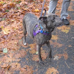
One of the best hikes I have had this winter. The trail is easy to follow, well marked, and the descriptions on line at the Forest Service, and on AllTrails give you a perfect picture of what you'll experience. I was in for the entire 7 mile loop, but my tracker told me it was 6.58. Whatevs. There is a parking lot with toilets and a map you can consult. No fee to park or hike this one. I arrived just before sunrise (it's winter, so that would be 07:30) and there were already 3 other cars. By the time I got back the lot was full and overflowing, so earlier is better. That's usually the case, though. I started on the upper loop and it was pretty much up up up but not too steep. I mean, it's the Gorge. It's not Wy'east. The views are to die for, especially with the sun starting to peak up over on the other side of the river. The trail is kinda muddy and slippy in some places, and the lower trail has a lot of long spans where the trail is nothing but rocks the size of your foot - appropriate footwear is essential. And if you bring your doggo, you should know that you can't get around that rock stuff on the lower trail. Your dog's paws might not be suited for that part. Upper trail, though, is great for good dogs. After enjoying the views from the top, the trail then takes you down to the river, where the views are even better! Rocky cliffs, streams, a waterfall. Just beautiful. The trail gets narrow and the drop offs are harrowing. By the time I got to that part it was starting to get busy, people with dogs (mostly on leash, thanks!), and larger groups. Most were considerate and were either wearing a mask or pulled one up when we got within sight of each other. See my note on masks at the end of this review. The last part for me was the walk along a road back up to the parking lot. I wasn't looking forward to this part, but the road was one of those barely paved country lanes, and it went past some nice little farms and horse properties. Very scenic, peaceful. And the gentle uphill kept me chugging along, nice and warm. Okay, masks. I work out a lot and I wear a mask when I train. Oh my gosh, what a pain. I totally get it when people say they can't breath through the mask. Once you get winded and start pulling deep breaths, the mask gets pulled against your face and now you're straining to get air through a cloth that is being pulled into your mouth. It does not feel good. Do it anyway! I've tried several things to mitigate this. My most successful was to use a pipe cleaner that I put next to my nose. The mask held it in place and it framed the mask slightly away from my mouth, so that when I was huffing and puffing the cloth didn't get pulled into my nose or mouth. The other thing I did was buy an athletic brand mask. My favorite is Under Armor. The material feels a little like neoprene, but it's lighter than that and the air passes through it pretty well. It is stiff enough, and shaped just right, so that when I really start gasping for breath it stays away from my face and doesn't get sucked in. Makes all the difference! I can get used to the feeling of being breathless - that's part of working out. What infuriates me is having cloth in my mouth. The Under Armor mask eliminates that nonsense. Now you know. Don't let winter weather and awkward masks keep you from enjoying our beautiful PNW!

Absolutely beautiful hike! We did the full 7 mile loop in about 3 hours. Beautiful views! Not too many people were there and everyone was respectful of distancing as well as mask wearing. I'd say it's a pretty hard hike because there's a lot of semi loose rock in places which hurts your feet if you don't have the right shoes on. Otherwise it's very doable. Nothing beats PNW Hikes!
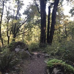

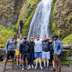
This is the most difficult hike I've attempted in the Gorge. There were tears. There were copious amounts of cussing. There were moments of utter defeat. And then I downloaded my photos. And it all melted away. Will I go back? Don't be ridiculous, my photos are perfect and my tears too fresh. Should you go? Absolutely. It's a 7 or so mile loop with about 1300 feet in elevation gain. Hey, at the very least you can become an I-too-survived-Cape-Horn survivor. The trail head for this little-known trail is between mile marker 26 and 27 on Hwy 14 on the Washington side of the Gorge. It starts out innocently enough - meandering trail through heavily-forested hillsides. There is lots of up, up, up, but the thought of the views when we finally clear the treeline keeps us climbing. And the reward was absolutely worth it. No question. My frustration came with the down, down, down. It seemed never-ending. And just when I thought, "Enough already," we came across what seemed like *miles* of loose shale switchbacks that required precise foot placement, and yielded very, very slow progress. This loop has everything: Shaded forest, forest critters, breathtaking panoramic views of the Gorge, wildflower meadows, waterfalls, lots and lots and lots of loose shale, great birding, the occasional garter snake, and even some country roads. It's not for the novice. Bring a positive attitude. Bring lots of water (I emptied my Camelbak before the end of the hike). And for crying out loud bring your camera.

Good for a beginner hike, but not much of a challenge if you go hiking regularly. We parked in the larger parking lot. We went on the upper trail and walked all the way down to one of the parking lots on the other side and walked back. The view was quite nice even though the elevation gain wasn't very high, in my opinion. Very family friendly, as we did see quite a few kids up at the top of the trail. Lots of flowers, berries, and the occasional mushroom line the trail and overall, the view was fantastic

11 months ago
Great trail. Fantastic any time of year, slightly less so during falcon breeding season.. (but a very worthwhile imposition!) read more


4 years ago
Very clean and clear trails. We went in the evening on a warmer overcast day. Not busy, only ran into a few people on the way and had no problems finding a parking spot. We also only hiked up to the first viewpoint but boy, was it a view. Absolutely gorgeous hike and not too far out of portland. Super easy to find and has parking lot and well maintenanced bathrooms. Great spot to ;) read more
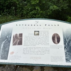
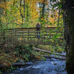
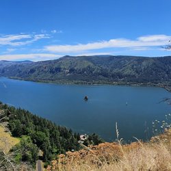
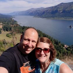
We hiked 5.2 miles out and back on the upper trail through a pleasant forest of coniferous and deciduous trees, sweeping views of the Columbia Gorge. Elevation gain was 1,000 feet. It was a good hike under partly cloudy and rainy skies, although the trail was muddy and slick in many spots. Yes, I slipped and landed on my shoulder and booty. Be prepared for a little mud on your pants as you slip slop along the muddy sections. The payoff is standing atop the Nancy Russell Overlook for one of the most breathtaking views in all the Gorge, even on a cloudy day. We can thank Nancy for her conservation efforts and founder of Columbia Gorge to keep the Gorge in its natural wonder free of major land development. You can add another 3 miles or so to your hike on the lower trail, which incidentally is closed February 1 to July 15 for Peregrine falcon breeding and nesting. We'll be back in the spring on a sunny day for another hike when the wildflowers are in bloom. Google Friends of the Columbia Gorge for trail information and other trails in the Gorge. It is Gorge-ous! Located just north of WA Hwy 14 near milepost 26. Turn left on Salmon Falls and immediately right into the Park and Ride. The trail begins across the road. It's about 35 miles from downtown PDX! How close is that if you got some wheels? Bring a rain pancho. Stand clear of steep cliffs. read more


Another weekend, another hike with an 8 year old. Now a quick warning to those that hike with kids. If you're just starting out with hiking with a child, this isn't the location to start at. The kiddo I hike with has been at this for three years now and we're pretty much past the whining stage. The lower trail says it's for experienced hikers and the upper trail.....is steep! No joke. I don't know the elevation and we didn't see it posted but the switchbacks are many and it isn't an easy one. Granted, once you make it to the lookout point (roughly two miles) it's worth it. Also during the summer months it is very lush so the plants take over the trails as well. Watch out for thorns. At this time of year(summer) you'll only be able to hike four miles on the upper trail. It's closed off due to nesting falcons, so you won't get to see the waterfall out past the six mile point. Good luck! read more


One of the best hikes I have had this winter. The trail is easy to follow, well marked, and the descriptions on line at the Forest Service, and on AllTrails give you a perfect picture of what you'll experience. I was in for the entire 7 mile loop, but my tracker told me it was 6.58. Whatevs. There is a parking lot with toilets and a map you can consult. No fee to park or hike this one. I arrived just before sunrise (it's winter, so that would be 07:30) and there were already 3 other cars. By the time I got back the lot was full and overflowing, so earlier is better. That's usually the case, though. I started on the upper loop and it was pretty much up up up but not too steep. I mean, it's the Gorge. It's not Wy'east. The views are to die for, especially with the sun starting to peak up over on the other side of the river. The trail is kinda muddy and slippy in some places, and the lower trail has a lot of long spans where the trail is nothing but rocks the size of your foot - appropriate footwear is essential. And if you bring your doggo, you should know that you can't get around that rock stuff on the lower trail. Your dog's paws might not be suited for that part. Upper trail, though, is great for good dogs. After enjoying the views from the top, the trail then takes you down to the river, where the views are even better! Rocky cliffs, streams, a waterfall. Just beautiful. The trail gets narrow and the drop offs are harrowing. By the time I got to that part it was starting to get busy, people with dogs (mostly on leash, thanks!), and larger groups. Most were considerate and were either wearing a mask or pulled one up when we got within sight of each other. See my note on masks at the end of this review. The last part for me was the walk along a road back up to the parking lot. I wasn't looking forward to this part, but the road was one of those barely paved country lanes, and it went past some nice little farms and horse properties. Very scenic, peaceful. And the gentle uphill kept me chugging along, nice and warm. Okay, masks. I work out a lot and I wear a mask when I train. Oh my gosh, what a pain. I totally get it when people say they can't breath through the mask. Once you get winded and start pulling deep breaths, the mask gets pulled against your face and now you're straining to get air through a cloth that is being pulled into your mouth. It does not feel good. Do it anyway! I've tried several things to mitigate this. My most successful was to use a pipe cleaner that I put next to my nose. The mask held it in place and it framed the mask slightly away from my mouth, so that when I was huffing and puffing the cloth didn't get pulled into my nose or mouth. The other thing I did was buy an athletic brand mask. My favorite is Under Armor. The material feels a little like neoprene, but it's lighter than that and the air passes through it pretty well. It is stiff enough, and shaped just right, so that when I really start gasping for breath it stays away from my face and doesn't get sucked in. Makes all the difference! I can get used to the feeling of being breathless - that's part of working out. What infuriates me is having cloth in my mouth. The Under Armor mask eliminates that nonsense. Now you know. Don't let winter weather and awkward masks keep you from enjoying our beautiful PNW! read more


Absolutely beautiful hike! We did the full 7 mile loop in about 3 hours. Beautiful views! Not too many people were there and everyone was respectful of distancing as well as mask wearing. I'd say it's a pretty hard hike because there's a lot of semi loose rock in places which hurts your feet if you don't have the right shoes on. Otherwise it's very doable. Nothing beats PNW Hikes! read more


9 years ago
If you are looking for a short and quick hike to check out the gorge. I recommend this one. It's not very tough at all. Good scenery of the gorge once you hike up about a mile and a half. Well marked trail and pretty easy. read more


This is the most difficult hike I've attempted in the Gorge. There were tears. There were copious amounts of cussing. There were moments of utter defeat. And then I downloaded my photos. And it all melted away. Will I go back? Don't be ridiculous, my photos are perfect and my tears too fresh. Should you go? Absolutely. It's a 7 or so mile loop with about 1300 feet in elevation gain. Hey, at the very least you can become an I-too-survived-Cape-Horn survivor. The trail head for this little-known trail is between mile marker 26 and 27 on Hwy 14 on the Washington side of the Gorge. It starts out innocently enough - meandering trail through heavily-forested hillsides. There is lots of up, up, up, but the thought of the views when we finally clear the treeline keeps us climbing. And the reward was absolutely worth it. No question. My frustration came with the down, down, down. It seemed never-ending. And just when I thought, "Enough already," we came across what seemed like *miles* of loose shale switchbacks that required precise foot placement, and yielded very, very slow progress. This loop has everything: Shaded forest, forest critters, breathtaking panoramic views of the Gorge, wildflower meadows, waterfalls, lots and lots and lots of loose shale, great birding, the occasional garter snake, and even some country roads. It's not for the novice. Bring a positive attitude. Bring lots of water (I emptied my Camelbak before the end of the hike). And for crying out loud bring your camera. read more


Good for a beginner hike, but not much of a challenge if you go hiking regularly. We parked in the larger parking lot. We went on the upper trail and walked all the way down to one of the parking lots on the other side and walked back. The view was quite nice even though the elevation gain wasn't very high, in my opinion. Very family friendly, as we did see quite a few kids up at the top of the trail. Lots of flowers, berries, and the occasional mushroom line the trail and overall, the view was fantastic read more

My bottom line up front is this loop worth hiking. The views are beautiful. The trail has dirt, gravel road, rock and paved road surfaces. Parking is ready at Route 14 and they have a restroom and a good map on the board. The upper trail is strenuous but easy for those used to hiking. There are some some observation points with benches. The lower trail had a beautiful waterfall you can easily stand under but some rocky sections non hikers may find uncomfortable. People without hiking boots may be unhappy on these parts. I'm an east coaster and even compared to the Appalachian Trail this area is rocky. The only part that could use improvement is a dirt trail rather than a paved road on the lower section closest to the parking lot. It took me 3.5 hours but I'm in shape and fairly fast. I'd guess 4.25 would be typical for many. read more


6 years ago
14 years ago
13 years ago
More info about Cape Horn Trail
Ask the Community - Cape Horn Trail
Review Highlights - Cape Horn Trail


Why does Yelp recommend reviews?
1 review that is not currently recommended
The reviews below are not factored into the business's overall star rating.
4 years ago
Cape Horn Trail - hiking - Updated May 2026
Best of Skamania
People found Cape Horn Trail by searching for…
Hiking Trails With Waterfalls in Skamania, WA
Lookout Points in Skamania, WA
Scenic Overlook in Skamania, WA
Dog Friendly Hikes in Skamania, WA
Dog Friendly Trails in Skamania, WA
Scenic Places to Walk in Skamania, WA
Hiking With Kids in Skamania, WA
Off Road Trails in Skamania, WA
Waterfalls and Swimming Holes in Skamania, WA
Off Leash Dog Hikes in Skamania, WA
Beautiful Views in Skamania, WA
People who viewed Cape Horn Trail also viewed
Salmon Creek Greenway Trail
13 reviews
Hardy Ridge Trail
1 review
Burnt Bridge Creek Greenway
5 reviews
Hogan Butte Nature Park
8 reviews
Gillette Lake Hike
3 reviews
Glendoveer Fitness Trail
14 reviews
Hazelwood, Northeast Portland
Dry Creek Falls Hike
10 reviews
Cape Horn Look Out
3 reviews
Salmon Creek-Morgan Creek Natural Area
6 reviews
Hamilton Mountain Trail
10 reviews