C&O Canal Towpath Photos


More like C&O Canal Towpath
Recommended Reviews - C&O Canal Towpath
Start your review...

Reviews With Photos


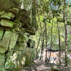
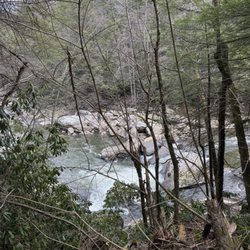
"Here is your country. Cherish these natural wonders, cherish the natural resources, cherish the history and romance as a sacred heritage, for your children and your children's children. Do not let selfish men or greedy interests skin your country of its beauty, its riches or its romance." ― Theodore Roosevelt Maryland's C & O Canal Towpath and Paw Paw Tunnel is a unique hike that blends historic manmade innovation and natural beauty. It's part Indiana Jones expedition, part Emile Hirsch in Into the Wild, part PBS Nature show and part Presidential Naturalist Teddy Roosevelt all in one. A chilly spring day yielded a bug-lessened adventure as we traipsed through the marshy lands. he laborious task took 22 years to construct with each worker putting in 15-18/hour days. It's sad to think that their efforts struggle to stay alive. The upkeep on the Paw Paw Tunnel has help it age gracefully compared to many of the locks along this path. The brick work on the majority of the tunnel is only seen by the well-prepared hiker with the use of flashlights. Look carefully and you'll be able to see a few bats that have taken up residence along these parts. Arrive ill-prepared and expect to be introduced the water puddles following we weather. The Potomac River views are also home to countless species not often seen populated areas. (I've seen pictures of bobcats and bald eagles) The river bends and winds in some areas along the trail and are ideal for meeting your fresh air quota or setting up camp for a little one-on-one with Mother Nature herself. Fun Facts: Dimensions of the Paw Paw Tunnel: 3,118ft long; 27ft wide; 24ft high (There are NO LIGHTS inside! - Bring a flashlight!) C & O years in operation: 1850-1924, some sections opened starting in 1830 Speed Limit in Canal: 4 mph Ghosts: There are legends of a headless ghost and the possibility of dead canal workers submerged beneath the concrete Paw Paw tunnel walkway.

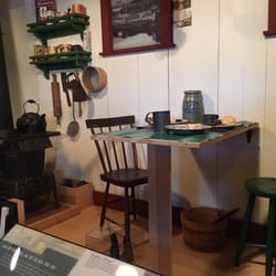
This review is for the Paw Paw Tunnel on the towpath between Cumberland, Md., and Paw Paw, WV. Visited here recently with my family...since I wasn't planning on hiking, I had some highly inappropriate footwear (i.e. flip-flops) and no flashlight, but it was still a fun adventure. My 6-year-old actually walked through the whole thing with a minimum of complaint, but I have to admit that I was surprised...because when you get to the middle, it is very dark. And wet. So wear shoes that can get muddy and soaked...and I think it's really best to have a flashlight along. Beautiful scenery on either side of the tunnel...I thought the WV side was especially nice (see photos). We also went to the C&O Canal Park in Green Spring, WV, which has a pleasant picnic area. Lots of people fish here and lots of bikers seem to take a break here. There is a lockhouse that you can walk through with a historical exhibit.

5 months ago


4 years ago
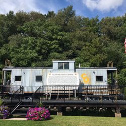
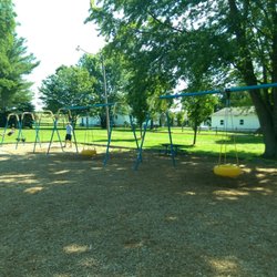
The C&O Canal Towpath in Cumberland MD is a lovely park in the downtown area. Located under the interstate bridges. It's also located near the Rail Road Train Station. Free to stroll around and enjoy Free parking There are paths to stroll,bridges to cross and signs to read. A great playground for kids. There is a replica of one of the canal boats and plenty of geese to meander around with read more


6 years ago
Nice views of the Potomac River. You can follow the trail up and down most of the east coast walking right along the edge of the river. Quiet spot to hang out with just you and your thoughts. Hiking is also encouraged as well. They also have a small parking lot which is free read more

"Here is your country. Cherish these natural wonders, cherish the natural resources, cherish the history and romance as a sacred heritage, for your children and your children's children. Do not let selfish men or greedy interests skin your country of its beauty, its riches or its romance." ― Theodore Roosevelt Maryland's C & O Canal Towpath and Paw Paw Tunnel is a unique hike that blends historic manmade innovation and natural beauty. It's part Indiana Jones expedition, part Emile Hirsch in Into the Wild, part PBS Nature show and part Presidential Naturalist Teddy Roosevelt all in one. A chilly spring day yielded a bug-lessened adventure as we traipsed through the marshy lands. he laborious task took 22 years to construct with each worker putting in 15-18/hour days. It's sad to think that their efforts struggle to stay alive. The upkeep on the Paw Paw Tunnel has help it age gracefully compared to many of the locks along this path. The brick work on the majority of the tunnel is only seen by the well-prepared hiker with the use of flashlights. Look carefully and you'll be able to see a few bats that have taken up residence along these parts. Arrive ill-prepared and expect to be introduced the water puddles following we weather. The Potomac River views are also home to countless species not often seen populated areas. (I've seen pictures of bobcats and bald eagles) The river bends and winds in some areas along the trail and are ideal for meeting your fresh air quota or setting up camp for a little one-on-one with Mother Nature herself. Fun Facts: Dimensions of the Paw Paw Tunnel: 3,118ft long; 27ft wide; 24ft high (There are NO LIGHTS inside! - Bring a flashlight!) C & O years in operation: 1850-1924, some sections opened starting in 1830 Speed Limit in Canal: 4 mph Ghosts: There are legends of a headless ghost and the possibility of dead canal workers submerged beneath the concrete Paw Paw tunnel walkway. read more


 wood - Parks Near Me - Cumberland, Maryland")
This review is for the Paw Paw Tunnel on the towpath between Cumberland, Md., and Paw Paw, WV. Visited here recently with my family...since I wasn't planning on hiking, I had some highly inappropriate footwear (i.e. flip-flops) and no flashlight, but it was still a fun adventure. My 6-year-old actually walked through the whole thing with a minimum of complaint, but I have to admit that I was surprised...because when you get to the middle, it is very dark. And wet. So wear shoes that can get muddy and soaked...and I think it's really best to have a flashlight along. Beautiful scenery on either side of the tunnel...I thought the WV side was especially nice (see photos). We also went to the C&O Canal Park in Green Spring, WV, which has a pleasant picnic area. Lots of people fish here and lots of bikers seem to take a break here. There is a lockhouse that you can walk through with a historical exhibit. read more


17 years ago
15 years ago
12 years ago


16 years ago
14 years ago
11 years ago
11 years ago
9 years ago
More info about C&O Canal Towpath
13 Canal St
Cumberland, MD 21502
Directions
Hours
Outdoor Amenities
Ask the Community - C&O Canal Towpath
Review Highlights - C&O Canal Towpath


Why does Yelp recommend reviews?
1 review that is not currently recommended
The reviews below are not factored into the business's overall star rating.
11 years ago
C&O Canal Towpath - parks - Updated May 2026
Best of Cumberland
People found C&O Canal Towpath by searching for…
Fishing in Cumberland, Maryland
Campgrounds in Cumberland, Maryland
Things to Do in Cumberland, Maryland
Playgrounds in Cumberland, Maryland
Hiking in Cumberland, Maryland
Photo Spots in Cumberland, Maryland
Hiking Trails With Waterfalls in Cumberland, Maryland
Places to Swim in Cumberland, Maryland
Scenic Views in Cumberland, Maryland
Places to Take Pictures in Cumberland, Maryland
Scenic Drive in Cumberland, Maryland
Beautiful Views in Cumberland, Maryland
Parks for Kids in Cumberland, Maryland
Walking Trails in Cumberland, Maryland
Public Running Track in Cumberland, Maryland
Free Things to Do With Kids in Cumberland, Maryland
Fishing Spots in Cumberland, Maryland
Natural Hot Springs in Cumberland, Maryland
Picnic Spots in Cumberland, Maryland
Sunset View in Cumberland, Maryland
Places to Walk Around in Cumberland, Maryland
Nature Trails in Cumberland, Maryland
Trending Searches in Cumberland, MD
Botanical Gardens near C&O Canal Towpath
Bounce House Rentals near C&O Canal Towpath
Campgrounds near C&O Canal Towpath
Floral Designers near C&O Canal Towpath
Garden Center near C&O Canal Towpath
Nurseries & Gardening near C&O Canal Towpath
Outdoor Furniture Stores near C&O Canal Towpath
Party Equipment Rentals near C&O Canal Towpath
Pedicure near C&O Canal Towpath
Pick Your Own Farms near C&O Canal Towpath
Picnic Areas near C&O Canal Towpath
Places To Take Pictures near C&O Canal Towpath
Pool Supplies near C&O Canal Towpath
Rv Rental near C&O Canal Towpath
Scenic Drive near C&O Canal Towpath
Splash Pad near C&O Canal Towpath
Swimming Holes near C&O Canal Towpath
Browse Articles
Browse Nearby
BEST of Cumberland, Maryland Playgrounds near C&O Canal Towpath
BEST of Cumberland, Maryland Coffee near C&O Canal Towpath
BEST of Cumberland, Maryland Restaurants near C&O Canal Towpath
BEST of Cumberland, Maryland Things to Do near C&O Canal Towpath
BEST of Cumberland, Maryland Walking Trails near C&O Canal Towpath
BEST of Cumberland, Maryland Breakfast near C&O Canal Towpath
BEST of Cumberland, Maryland Campgrounds near C&O Canal Towpath
BEST of Cumberland, Maryland Sightseeing near C&O Canal Towpath
Browse Brands
Related Searches in Cumberland, MD
Best Fishing Locations and Guides in Cumberland, Maryland
Best Parks for Parties and Events in Cumberland, Maryland
Best Water Parks for Kids in Cumberland, Maryland
Check Out Off Road Trails in Cumberland, Maryland
Discover Kids Indoor Play Area Venues in Cumberland, Maryland
Discover Popular Photo Spots in Cumberland, Maryland
Discover Top Nature Parks to Visit in Cumberland, Maryland
Discover the Best Beaches in Cumberland, Maryland
Enjoy Tent Camping Spots Around Cumberland, Maryland
Enjoy the Best Walking Trails in Cumberland, Maryland
Explore Beautiful Botanical Gardens in Cumberland, Maryland
Explore Family-Friendly Zoos and Wildlife in Cumberland, Maryland
Explore Free Kids Activities Near Cumberland, Maryland
Explore Free Picnic Areas Around Cumberland, Maryland
Explore Free Things to Do Around Cumberland, Maryland
Explore Fun Activities to Do in Cumberland, Maryland
Explore Landmarks & Historical Buildings in Cumberland, Maryland
Explore Parks With Pull Up Bars in Cumberland, Maryland
Explore Popular Campgrounds Near Cumberland, Maryland
Explore Popular Picnic Areas Around Cumberland, Maryland
Explore Popular RV Parks Around Cumberland, Maryland
Explore Popular Scenic Overlook Points in Cumberland, Maryland
Explore Popular Scenic Views Near Cumberland, Maryland
Explore Scenic Lakes to Visit in Cumberland, Maryland
Explore Secret Spots Worth Visiting in Cumberland, Maryland
Explore Summer Camps for All Ages in Cumberland, Maryland
Explore Top Dog Parks in Cumberland, Maryland Near You
Explore Top Gyms in Cumberland, Maryland Now
Explore Top Water Parks in Cumberland, Maryland Today
Explore the Best Swimming Holes Around Cumberland, Maryland
Find Fun Things to Do With Kids in Cumberland, Maryland
Find Parks and Recreation Activities in Cumberland, Maryland
Find Top Dog Friendly Parks to Visit in Cumberland, Maryland
Find Top Skate Parks in Cumberland, Maryland for All Skill Levels
Find Top Skating Rinks in Cumberland, Maryland for All Ages
Find Top-Rated Waterfalls in Cumberland, Maryland Now
Find the Best Parks BBQ Grills in Cumberland, Maryland
Find the Best Swimming Pools in Cumberland, Maryland Today
Great Places to Swim in Cumberland, Maryland
Have Fun at a Splash Pad in Cumberland, Maryland
Hiking Trails With Waterfalls in Cumberland, Maryland
Must-See Tourist Attractions Around Cumberland, Maryland
Parks With Basketball Courts for Games in Cumberland, Maryland
Picnic Areas With BBQ Pits Available in Cumberland, Maryland
Popular Kids Activities in Cumberland, Maryland
Popular Things to Do in Cumberland, Maryland
Top Hiking Trails to Explore in Cumberland, Maryland
Top Running Trails to Explore in Cumberland, Maryland