
Blazer's Trail Photos


More like Blazer's Trail
Recommended Reviews - Blazer's Trail
Start your review...

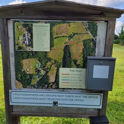
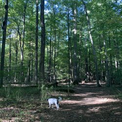
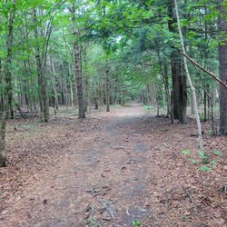
I wished my elementary school had an outdoor class/trail! This trail is located behind the Roaring Brook School elementary school; when you walk across the soccer field, you will see the entrance sign. The trail was easy and flat; there were leaves and some roots/rocks. When you first walk in, you will see a bunch of benches and a big rock in the front; auditorium style for the kids. There was a little free library which my toddler loved. They had a story book along the trail; every few trees, there was a page of the book. The book we read was "Old Rock (is not boring)", this was really cute. There were plaques with information about the trail; one interesting one was regarding the rock wall that was built in the 1700s because it used to be farmland. On the trail, you will see houses and backyards. Overall, we had a fun time walking on this cute little trail. If school is closed, you can go to the playground at the school to release more toddler energy. read more


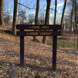
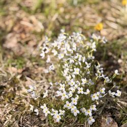
"I'm going down in a blaze of glory Take me now but know the truth" (Bon Jovi) How can you jazz up a half-mile looped trail? How about incorporating a literacy theme, children's books, family reading time, and outdoor classrooms into the mix? You'll find such a trail behind the Roaring Brook Elementary School in Avon. Just walk across the athletic field, and you'll see a sign for the entrance to the trail. Throughout the trail, you'll see displays highlighting children's books as a place where families can stop and do some reading. The trail is pretty much flat except for a moderate but small incline toward the beginning. There's an occasional tree root here and there, but the trail is pretty much easy to navigate. We saw two outdoor classrooms, quite a few nature related displays on local wildlife, and many displays that featured pages of this month's book. There will be different books featured throughout the year. This month, the Blazer's Trail committee has put up "One Little Bag," by Henry Cole. It's a pretty nice little trail, and the only thing that bothered us at today's walk was the bugs -tons and tons of mosquitos and gnats! Pro Tip --Who's Blazer? Why he's the anthropomorphic fox mascot of the Roaring Brook Elementary School. read more


More info about Blazer's Trail
30 Old Wheeler Ln
Avon, CT 06001
Directions
Hours
Outdoor Amenities


Blazer's Trail - hiking - Updated July 2026
Best of Avon
People found Blazer's Trail by searching for…
Trending Searches in Avon, CT
Blueberry Picking near Blazer's Trail
Boat Tours near Blazer's Trail
Cliff Jumping near Blazer's Trail
Cruising Spots near Blazer's Trail
Dog Friendly Trails near Blazer's Trail
Jet Ski Rental near Blazer's Trail
Kayak Rental near Blazer's Trail
Kids Activities Indoor near Blazer's Trail
Lookout Points near Blazer's Trail
Off Road Trails near Blazer's Trail
Outdoor Activities near Blazer's Trail
Peach Picking near Blazer's Trail
Public Shower near Blazer's Trail
Rainy Day Activities near Blazer's Trail
River Swimming near Blazer's Trail
Rock Quarry near Blazer's Trail
Scenic Night View near Blazer's Trail
Scenic Overlook near Blazer's Trail
Soccer Store near Blazer's Trail
Sunrise View near Blazer's Trail
Swimming Holes near Blazer's Trail
Swimming Lakes near Blazer's Trail
U Pick Farms near Blazer's Trail
Watch Sunset near Blazer's Trail
Browse Articles
Browse Nearby
BEST of Avon, Connecticut Coffee near Blazer's Trail
BEST of Avon, Connecticut Restaurants near Blazer's Trail
BEST of Avon, Connecticut Things to Do near Blazer's Trail
BEST of Avon, Connecticut Walking Trails near Blazer's Trail
BEST of Avon, Connecticut Breakfast near Blazer's Trail
BEST of Avon, Connecticut Parks near Blazer's Trail
BEST of Avon, Connecticut Campgrounds near Blazer's Trail
Browse Brands
Related Searches in Avon, CT
Affordable Canoe Rental Options in Avon, Connecticut
Affordable Kayak Rental Services in Avon, Connecticut
Best Dog Hiking Trails Around Avon, Connecticut
Best Fishing Locations and Guides in Avon, Connecticut
Best Places for Horseback Riding in Avon, Connecticut
Best Sightseeing Experiences Available in Avon, Connecticut
Best Waterfalls and Swimming Holes in Avon, Connecticut
Discover Dog Friendly Trails to Explore in Avon, Connecticut
Discover Popular Bike Trails in Avon, Connecticut
Discover Top State Parks to Visit in Avon, Connecticut
Discover a Hiking Trail in Avon, Connecticut
Discover the Best Night Hike Trails in Avon, Connecticut
Dog-Friendly Hikes With Dogs in Avon, Connecticut
Enjoy Camping Adventures Around Avon, Connecticut
Enjoy Kayaking Adventures in Avon, Connecticut
Enjoy Off Leash Dog Hikes in Avon, Connecticut
Enjoy Scenic Places to Walk in Avon, Connecticut
Enjoy Tent Camping Spots Around Avon, Connecticut
Enjoy a Beautiful Waterfall Hike in Avon, Connecticut
Enjoy the Best Picnic Spots and Ideas in Avon, Connecticut
Enjoy the Best Walking Trails in Avon, Connecticut
Explore Beautiful Parks and Green Spaces in Avon, Connecticut
Explore Easy Hikes Perfect for All in Avon, Connecticut
Explore Fun Activities to Do in Avon, Connecticut
Explore Popular Campgrounds Near Avon, Connecticut
Explore Scenic Lakes to Visit in Avon, Connecticut
Explore Top Dog Parks in Avon, Connecticut Near You
Explore the Best Swimming Holes Around Avon, Connecticut
Explore the Scenic River in Avon, Connecticut
Family Friendly Hiking With Kids in Avon, Connecticut
Find Beautiful Views in Avon, Connecticut
Find Top Dog Friendly Parks to Visit in Avon, Connecticut
Find the Best Parks for Picnics in Avon, Connecticut
Find the Best Playgrounds to Visit in Avon, Connecticut
Hiking Trails With Waterfalls in Avon, Connecticut
Off Leash Dog Hiking Trails in Avon, Connecticut
Popular Fishing Spots to Explore in Avon, Connecticut
Popular Outdoor Activities to Try in Avon, Connecticut
Popular Picnic Spots to Visit in Avon, Connecticut
Safe River Swimming Areas in Avon, Connecticut
Safe and Fun Parks for Kids in Avon, Connecticut
Top Hiking Trails to Explore in Avon, Connecticut
Top Paddleboarding Activities in Avon, Connecticut
Top Playgrounds for Kids to Enjoy in Avon, Connecticut
Top Running Trails to Explore in Avon, Connecticut
Top Swimming Lakes to Enjoy in Avon, Connecticut
Top Swimming Spots and Pools in Avon, Connecticut
People who viewed Blazer's Trail also viewed
Sweetheart Mountain Trails
1 review
Mary Conklin Sanctuary Trails
1 review
Bunker Hill Trailhead
1 review
Machimoodus State Park
7 reviews
Pistol Creek Park
7 reviews
Dividend Pond
3 reviews
Air Line State Park Trail S
2 reviews
The John McManama Nature Trail
1 review
George Dudley Seymour State Park
1 review
Trout Brook Trail
4 reviews