1. Blalock Wildlife Sanctuary

0

Llano, CA

Cancel

Open app

Search

Blalock Wildlife Sanctuary

5.0 (1 review)

Blalock Wildlife Sanctuary Photos

You might also consider

More like Blalock Wildlife Sanctuary

Recommended Reviews - Blalock Wildlife Sanctuary

Your trust is our priority, so businesses can't pay to alter or remove their reviews. Learn more about reviews.
Yelp app icon
Browse more easily on the app
Review Feed Illustration

4 months ago

Helpful 3
Thanks 1
Love this 4
Oh no 0

You might also consider

Verify this business for free

People searched for Parks 261 times last month within 15 miles of this business.

Verify this business

Islip Saddle

Islip Saddle

4.5(6 reviews)
2.2 mi

Beautiful hike near the intersection of the 2 and the 39. Parking lot and pristine trails are…read morewell-maintained. Well worth the drive up from the Los Angeles basin. Check traffic, weather and fire status; the forest is extremely flammable at the moment. Bring water, snacks and first aid kit. An Adventure Pass is required to park within Angeles National Forest. Be prepared for a work-out and some beautiful views.

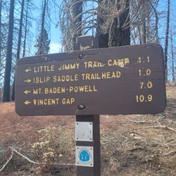
This is a strong 4 star hike...near Mount Baden-Powell and similar in many ways. Use the All Trails…read moreapp to get directions. Parking and the trailhead is on Hwy 2. We took the 210 to the 2 Hwy near La Canada Flintridge and it took us about 50 mins and 40 miles of twists and turns while sharing the road with motorcycles and high performance cars that are testing their cars handling. You will pass the parking area for Switzer Falls (see my review for that one) and you will pass the Red Box parking area you can use to do the Strawberry Peak hike (see my review haha) and still will need to continue on Angeles Crest Hwy for about 25 more minutes. If you want you can continue tpass the main parking area for the Islip saddle about one mile to the east and find some parking on the side of the highway that will allow you to take a shortcut trail that connects with the main trail but is about .4 miles shorter, so .8 miles RT...you can see the start of the trail near the metal barrier blocking any traffic on the access road. The first .6 miles is pretty steep and then you connect to the main trail and head left to the Little Jimmy Campground which is 1.1 miles and pretty flat. When you reach the campground it gets a bit confusing with intersecting trails. Don't stop here, continue on for about 1.5 miles to reach the Mt. Islip peak. The 3rd mile is the steepest and you will gain about 550 ft and pass the 8,000 ft elevation level and come to a fork in the trail that is well marked and you will make a right to go about .2 miles to the peak. It was 3.2 miles to the peak and 6.4 miles RT using the shortcut starting area that I mentioned in the first paragraph. At the top is the ruins of a small structure, some concrete squares, and a plastic and metal box with some notebooks. There is no sign with the name and elevation of the peak but it is about 8,250 ft. above sea level. There are some great views, not quite as great as Baden-Powell. This is a moderate hike, definitely not hard. We completed the hike in 2.5 hrs with no running. There are parts that are exposed to the sun, but equal amounts that have shade. I loved that we only came across 6 total people while hiking. I just hate that it takes so long to get here and especially the amount of driving the incredibly curvy Hwy 2.

Photos
Islip Saddle - Natural spring

Natural spring

Islip Saddle
Islip Saddle

See all

Blalock Wildlife Sanctuary - parks - Updated October 2026

Loading...
Loading...
Loading...