Bethany Historical Marker Photos


More like Bethany Historical Marker
Recommended Reviews - Bethany Historical Marker
Start your review...

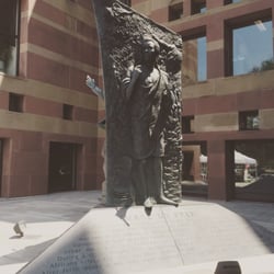
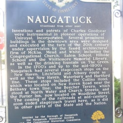
Know your Bible? OK, prove it. What City near Jerusalem was home to siblings Mary, Martha, and Lazarus? Need another hint- it was also home to Simon the Leper. The answer is Bethany, the namesake for this town of around 6,000 in Connecticut's New Haven County. In front of Town Hall is this 2-sided marker from the CT Historical Commission, in the familiar white lettering on a blue background. It has different inscriptions on both sides. The marker was dedicated in 1981 and is in very good condition. The blue background is fairly bright with no signs of fading or peeling. The full inscription reads: Bethany In 1738 Amity Parish in New Haven and Milford, including most of present-day Woodbridge and Bethany, was incorporated by the General Assembly of Connecticut Colony. The earliest schoolhouse was built in 1750 in the northern half of Amity Parish. It was located first at Rocky Corner, near the intersection of Meyer and Old Amity Roads. In 1762 the northern part of the Parish was made a distinct ecclesiastical society and was named Bethany for the Biblical village at the foot of the Mount of Olives near Jerusalem. In 1832, by act of the General Assembly, Bethany Parish was separated from Woodbridge and incorporated as the Town of Bethany. The Straitsville area was taken in 1844, together with parts of Oxford and Waterbury, to become Naugatuck. In 1871, also as a result of legislative action, the western area became part of Beacon Falls, incorporated as a town with portions added from Oxford, Naugatuck, and Seymour. Some notable examples of architecture dating from the period before incorporation of the town still stand in the vicinity and are attributed to David Hoadley (1774 - 1839) of Waterbury, a self-taught builder-architect who became a leading designer of church buildings in the first decades of the 19th century. His skill in domestic construction is displayed in the Beecher (or Hoadley) House of 1807 with very fine detail both on the exterior and in the central hall and rooms of the interior. Christ Church, Episcopal, dating from 1809, is also from the hand of Hoadley. During its construction, services were held in the upstairs ballroom of the Beecher House. The church is little changed on the outside, but the interior reflects extensive alterations made in accordance with changing taste over the last one hundred years. Regarded as the high point of Hoadley's achievement is United (North) Church of 1814 on the New Haven Green. Erected by the Town of Bethany and the Connecticut Historical Commission 1981 157 CT towns done, 13 to go read more


More info about Bethany Historical Marker


Bethany Historical Marker - landmarks - Updated May 2026
Best of Bethany
People found Bethany Historical Marker by searching for…
Things to Do in Bethany, Connecticut
Places to Take Pictures in Bethany, Connecticut
Scenic Overlook in Bethany, Connecticut
Photo Spots in Bethany, Connecticut
Public Services & Government in Bethany, Connecticut
View Points in Bethany, Connecticut
Birthday Party Venues in Bethany, Connecticut
Boardwalk in Bethany, Connecticut
Landmarks in Bethany, Connecticut
Religious Organizations in Bethany, Connecticut
Historical Sites in Bethany, Connecticut
Baby Shower Locations in Bethany, Connecticut
Field Trips in Bethany, Connecticut
Night View in Bethany, Connecticut
Places to Walk in Bethany, Connecticut
Browse Nearby
BEST of Bethany, Connecticut Restaurants near Bethany Historical Marker
BEST of Bethany, Connecticut Coffee near Bethany Historical Marker
BEST of Bethany, Connecticut Things to Do near Bethany Historical Marker
BEST of Bethany, Connecticut Shopping near Bethany Historical Marker
BEST of Bethany, Connecticut Breakfast near Bethany Historical Marker
BEST of Bethany, Connecticut Parks near Bethany Historical Marker
BEST of Bethany, Connecticut Hotels near Bethany Historical Marker