Bridgewater Historical Marker Photos


More like Bridgewater Historical Marker
Recommended Reviews - Bridgewater Historical Marker
Start your review...

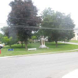
Located in front of the Bridgewater Historical Society, the Historical Marker is easily accessible with parking available behind the building. The parking entrance is closer to the library. There is also a nearby sign for a Blue Star Memorial put up by the Roxbury-Bridgewater Garden Club. The actual historical marker reads: In 1722 Samuel Clark, an original proprietor of New Milford, had a portion of his share of land surveyed in the southerly part of that town known as Shepaug Neck. Although this later became known as Bridgewater, it was not incorporated as a separate town until 1856. Among the earliest settlers was Joseph Treat, grandson of Robert Treat, a colonial governor of Connecticut. Others included the four sons of Jeremiah Canfield, Sr. Descendents of these families played a prominent roll in the early history of the area. The first school district was established in 1758. By the latter part of the 18th century petitions were made to New Milford for a separate ecclesiastical society, a request granted in 1803. A meeting house, the present Congregational church, was erected in 1807. Most early settlers were Congregationalists, but other faiths were represented as well. Until about 1800 a Baptist church stood on what is now called Christian Street. Episcopal worship began in private homes around 1810, and a church was built in 1836. Present St. Mark's church was erected in 1859. Early Bridgewater was divided into several districts, each having its own store, school, mills, blacksmith and woodworking shops. Sheep were raised and tobacco grown. Dairy farming developed in the 19th century. Hat making flourished 1823 to 1870, when Glover Sanford & Sons had a factory on Hat Shop Hill. For some years Bridgewater was the boyhood home of Captain William B Burnham, founder of the American Hawaiian Steamship Company. His generous bequests made possible the library and school on Main Street that bear his name. The town was also the birthplace and place of business of Charles B. Thompson, a leading pioneer in mail-order selling. Bridgewater today is largely residential. read more
More info about Bridgewater Historical Marker


Bridgewater Historical Marker - landmarks - Updated July 2026
Best of Bridgewater
People found Bridgewater Historical Marker by searching for…
24 Hour Library in Bridgewater, CT
Places to Take Pictures in Bridgewater, CT
Post Offices in Bridgewater, CT
Scenic Overlook in Bridgewater, CT
Scenic View in Bridgewater, CT
Things to Do in Bridgewater, CT
Library Open Late in Bridgewater, CT
Free Parking in Bridgewater, CT
Photo Spots in Bridgewater, CT
Field Trips in Bridgewater, CT
Religious Organizations in Bridgewater, CT
Public Services & Government in Bridgewater, CT
Attractions in Bridgewater, CT
Abandoned Places in Bridgewater, CT
Historical Sites in Bridgewater, CT
Browse Nearby
BEST of Bridgewater, Connecticut Restaurants near Bridgewater Historical Marker
BEST of Bridgewater, Connecticut Things to Do near Bridgewater Historical Marker
BEST of Bridgewater, Connecticut Coffee near Bridgewater Historical Marker
BEST of Bridgewater, Connecticut Hiking near Bridgewater Historical Marker
BEST of Bridgewater, Connecticut Breakfast near Bridgewater Historical Marker
BEST of Bridgewater, Connecticut Shopping near Bridgewater Historical Marker
BEST of Bridgewater, Connecticut Hotels near Bridgewater Historical Marker
Browse Brands
Browse Articles
People who viewed Bridgewater Historical Marker also viewed
Pierce Academy Historical Marker
1 review
Burlington World War II -Korean - Viet Nam Wars Memorial
1 review
Balanced Rock
6 reviews
Farmington Veterans Memorial
1 review
Plainville Veterans Memorial Park
1 review
Gunn Memorial Library
2 reviews
Wolcott Historical Marker
1 review
Hearthstone Castle
3 reviews
1902 Connecticut Constitutional Convention Pin Oak
1 review
Bethel Historical Marker
1 review